
To adapt to rising sea levels, coastal wetlands can migrate landward at the expense of adjacent freshwater wetlands and upland ecosystems, but migration can be hindered by natural and anthropogenic barriers. This photo shows marsh migration constrained by topographic and urban barriers in southern California.
Karen Thorne, Ph.D. (Former Employee)
Science and Products
Filter Total Items: 28

Assessing Genomic Diversity and Clonality in Tape Seagrass in Guam and Surrounding Pacific Islands to Inform Climate Resilient Restoration
Project Overview Seagrass meadows support island communities by sustaining fisheries and protecting shorelines. However, some species, such as tape grass, may lack the genetic variation needed to survive and adapt to warmer, saltier ocean waters. Researchers supported by this Pacific Islands CASC project will sequence the tape grass genome and assess genetic variation across Micronesia...

Habitat Vulnerability to Climate Change: Identifying Climate Change Induced Mass Mortality Events Across Large Landscapes of the United States
USGS researchers will characterize extreme climatic events across U.S. following a review of case studies of mass mortality events associated with climate extremes including drought, precipitation, freeze, heat waves, and storm events.

Coastal Wetland Vulnerability to Climate Change and Sea-Level Rise: Understanding Ecological Thresholds and Ecosystem Transformations
Eighteen USGS coastal scientists from all four coasts of the conterminous United States are working together to advance the understanding of climate change and sea-level rise impacts to coastal wetlands.
By
California Water Science Center, Chesapeake Bay Activities, Eastern Ecological Science Center, Florence Bascom Geoscience Center, Great Lakes Science Center, Pacific Coastal and Marine Science Center, St. Petersburg Coastal and Marine Science Center, Western Ecological Research Center (WERC), Western Geographic Science Center, Wetland and Aquatic Research Center , Woods Hole Coastal and Marine Science Center
Spread of invasive vegetation under climate change in the national parks of the Klamath Region
Project Overview: The Klamath Region of Oregon and California is a global hotspot of biodiversity, but invasive species, climate change, and severe fires threaten native biodiversity, even within national parks. Scientists supported by this Southwest CASC project will create early-warning maps of where invasive plants are most likely to spread, helping national park managers target their
Enhancing Community and Wildlife Resilience to Sea‐Level Rise and Infrastructure Development in the San Pablo Baylands
Project Overview: The San Pablo Baylands support critical wildlife habitat and major transportation infrastructure, but the combined effects of sea-level rise and planned highway redesigns on habitat and public access remain uncertain. Scientists supported by this Southwest CASC project will work with federal, state, and regional managers to fill key data gaps and model how sea-level...
Modeling vulnerability for San Francisco Bay estuary tidal marshes
Karen Thorne researches the effects of inundation and ecological processes within the San Francisco Bay-Delta estuary.

Developing a Pacific Mangrove Monitoring Network (PACMAN) in Response to Sea Level Rise
Continued sea-level rise from a changing climate is expected to result in the loss of many coastal mangrove trees, which, will strongly affect human populations on isolated Western Pacific islands as they rely heavily on mangrove forests for food (fish, shrimp, and crabs), building materials, and firewood. Mangroves also protect local communities from tsunamis and cyclones and are...

Wetland Carbon Working Group: Improving Methodologies and Estimates of Carbon and Greenhouse Gas Flux in Wetlands
WARC researchers are working to quantify the impacts of future climate and land use/land cover change on greenhouse gas emissions and reductions.

Sea-level Rise Vulnerability of Mangrove Forests in Micronesia and the Pacific
The USGS and partners are studying how mangrove forests in the Federated States of Micronesia may respond to sea-level rise over the coming century. Their projections will help Micronesian communities plan for the future.

The Response of Coastal Wetlands to Sea-level Rise: Understanding how Macroscale Drivers Influence Local Processes and Feedbacks
The purpose of this work is to advance our understanding of how coastal wetland responses to sea-level rise (SLR) within the conterminous United States are likely to vary as a function of local, regional, and macroscale drivers, including climate. Based on our interactions with managers and decision makers, as well as our knowledge of the current state of the science, we propose to: (a) conduct a...

The response of coastal wetlands to sea-level rise: Understanding how macroscale drivers influence local processes and feedbacks
The purpose of this work is to advance our understanding of how coastal wetland responses to SLR within the conterminous United States are likely to vary as a function of local, regional, and macroscale drivers, including climate. Based on our interactions with managers and decision makers, as well as our knowledge of the current state of the science, we propose to (a) conduct a national synoptic...

Science to Inform the Management of Mangrove Ecosystems Undergoing Sea Level Rise at Ding Darling National Wildlife Refuge, Sanibel Island, Florida
Mangroves are forested tidal wetlands that occur in tropical, sub-tropical, and warm temperate coastal regions around the world. Mangroves occupy a significant area of coastlines globally and provide important ecosystem services to humans and wildlife. These services include aesthetic value, storm protection, food provisioning, recreation, critical wildlife habitat, and biological carbon

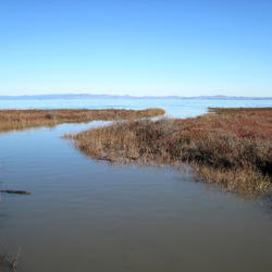
Marsh Migration Southern California
To adapt to rising sea levels, coastal wetlands can migrate landward at the expense of adjacent freshwater wetlands and upland ecosystems, but migration can be hindered by natural and anthropogenic barriers. This photo shows marsh migration constrained by topographic and urban barriers in southern California.

Sea-level Rise Scenario for San Francisco Bay Estuary - Arrowhead Marsh
Sea-level Rise Scenario for San Francisco Bay Estuary - Arrowhead MarshHow will sea level rise impact coastal ecosystems like salt marshes? Will plant species change and shift available habitat for local wildlife? Or will the marsh be completely inundated? USGS scientists are conducting extensive elevation and habitat surveys along the U.S. Pacific Coast, and using the data to model sea level rise impact for the next 100 years.

Sea-level Rise Scenario for San Francisco Bay Estuary - BlackJohn Marsh
Sea-level Rise Scenario for San Francisco Bay Estuary - BlackJohn MarshHow will sea level rise impact coastal ecosystems like salt marshes? Will plant species change and shift available habitat for local wildlife? Or will the marsh be completely inundated? USGS scientists are conducting extensive elevation and habitat surveys along the U.S. Pacific Coast, and using the data to model sea level rise impact for the next 100 years.

Sea-level Rise Scenario for San Francisco Bay Estuary - China Camp State Park
Sea-level Rise Scenario for San Francisco Bay Estuary - China Camp State ParkHow will sea level rise impact coastal ecosystems like salt marshes? Will plant species change and shift available habitat for local wildlife? Or will the marsh be completely inundated? USGS scientists are conducting extensive elevation and habitat surveys along the U.S. Pacific Coast, and using the data to model sea level rise impact for the next 100 years.

Sea-level Rise Scenario for San Francisco Bay Estuary - Fagan Marsh
Sea-level Rise Scenario for San Francisco Bay Estuary - Fagan MarshHow will sea level rise impact coastal ecosystems like salt marshes? Will plant species change and shift available habitat for local wildlife? Or will the marsh be completely inundated? USGS scientists are conducting extensive elevation and habitat surveys along the U.S. Pacific Coast, and using the data to model sea level rise impact for the next 100 years.

Sea-level Rise Scenario for San Francisco Bay Estuary - Cogswell Marsh
Sea-level Rise Scenario for San Francisco Bay Estuary - Cogswell MarshHow will sea level rise impact coastal ecosystems like salt marshes? Will plant species change and shift available habitat for local wildlife? Or will the marsh be completely inundated? USGS scientists are conducting extensive elevation and habitat surveys along the U.S. Pacific Coast, and using the data to model sea level rise impact for the next 100 years.

Sea-level Rise Scenario for San Francisco Bay Estuary - Petaluma Marsh
Sea-level Rise Scenario for San Francisco Bay Estuary - Petaluma MarshHow will sea level rise impact coastal ecosystems like salt marshes? Will plant species change and shift available habitat for local wildlife? Or will the marsh be completely inundated? USGS scientists are conducting extensive elevation and habitat surveys along the U.S. Pacific Coast, and using the data to model sea level rise impact for the next 100 years.

Sea-level Rise Scenario for San Francisco Bay Estuary - West San Pablo Bay Marsh
Sea-level Rise Scenario for San Francisco Bay Estuary - West San Pablo Bay MarshHow will sea level rise impact coastal ecosystems like salt marshes? Will plant species change and shift available habitat for local wildlife? Or will the marsh be completely inundated? USGS scientists are conducting extensive elevation and habitat surveys along the U.S. Pacific Coast, and using the data to model sea level rise impact for the next 100 years.

Sea-level Rise Scenario for San Francisco Bay Estuary - San Pablo Bay Strip Marsh
Sea-level Rise Scenario for San Francisco Bay Estuary - San Pablo Bay Strip MarshHow will sea level rise impact coastal ecosystems like salt marshes? Will plant species change and shift available habitat for local wildlife? Or will the marsh be completely inundated? USGS scientists are conducting extensive elevation and habitat surveys along the U.S. Pacific Coast, and using the data to model sea level rise impact for the next 100 years.

Sea-level Rise Scenario for San Francisco Bay Estuary - Corte Madera Marsh
Sea-level Rise Scenario for San Francisco Bay Estuary - Corte Madera MarshHow will sea level rise impact coastal ecosystems like salt marshes? Will plant species change and shift available habitat for local wildlife? Or will the marsh be completely inundated? USGS scientists are conducting extensive elevation and habitat surveys along the U.S. Pacific Coast, and using the data to model sea level rise impact for the next 100 years.

Sea-level Rise Scenario for San Francisco Bay Estuary - Gambinini Marsh
Sea-level Rise Scenario for San Francisco Bay Estuary - Gambinini MarshHow will sea level rise impact coastal ecosystems like salt marshes? Will plant species change and shift available habitat for local wildlife? Or will the marsh be completely inundated? USGS scientists are conducting extensive elevation and habitat surveys along the U.S. Pacific Coast, and using the data to model sea level rise impact for the next 100 years.

Sea-level Rise Scenario for San Francisco Bay Estuary - Laumeister Marsh
Sea-level Rise Scenario for San Francisco Bay Estuary - Laumeister MarshHow will sea level rise impact coastal ecosystems like salt marshes? Will plant species change and shift available habitat for local wildlife? Or will the marsh be completely inundated? USGS scientists are conducting extensive elevation and habitat surveys along the U.S. Pacific Coast, and using the data to model sea level rise impact for the next 100 years.

Sea-level Rise Scenario for San Francisco Bay Estuary - Coon Island
Sea-level Rise Scenario for San Francisco Bay Estuary - Coon IslandHow will sea level rise impact coastal ecosystems like salt marshes? Will plant species change and shift available habitat for local wildlife? Or will the marsh be completely inundated? USGS scientists are conducting extensive elevation and habitat surveys along the U.S. Pacific Coast, and using the data to model sea level rise impact for the next 100 years.
Science and Products
Filter Total Items: 28
Assessing Genomic Diversity and Clonality in Tape Seagrass in Guam and Surrounding Pacific Islands to Inform Climate Resilient Restoration
Project Overview Seagrass meadows support island communities by sustaining fisheries and protecting shorelines. However, some species, such as tape grass, may lack the genetic variation needed to survive and adapt to warmer, saltier ocean waters. Researchers supported by this Pacific Islands CASC project will sequence the tape grass genome and assess genetic variation across Micronesia...
Habitat Vulnerability to Climate Change: Identifying Climate Change Induced Mass Mortality Events Across Large Landscapes of the United States
USGS researchers will characterize extreme climatic events across U.S. following a review of case studies of mass mortality events associated with climate extremes including drought, precipitation, freeze, heat waves, and storm events.
Coastal Wetland Vulnerability to Climate Change and Sea-Level Rise: Understanding Ecological Thresholds and Ecosystem Transformations
Eighteen USGS coastal scientists from all four coasts of the conterminous United States are working together to advance the understanding of climate change and sea-level rise impacts to coastal wetlands.
By
California Water Science Center, Chesapeake Bay Activities, Eastern Ecological Science Center, Florence Bascom Geoscience Center, Great Lakes Science Center, Pacific Coastal and Marine Science Center, St. Petersburg Coastal and Marine Science Center, Western Ecological Research Center (WERC), Western Geographic Science Center, Wetland and Aquatic Research Center , Woods Hole Coastal and Marine Science Center
Spread of invasive vegetation under climate change in the national parks of the Klamath Region
Project Overview: The Klamath Region of Oregon and California is a global hotspot of biodiversity, but invasive species, climate change, and severe fires threaten native biodiversity, even within national parks. Scientists supported by this Southwest CASC project will create early-warning maps of where invasive plants are most likely to spread, helping national park managers target their
Enhancing Community and Wildlife Resilience to Sea‐Level Rise and Infrastructure Development in the San Pablo Baylands
Project Overview: The San Pablo Baylands support critical wildlife habitat and major transportation infrastructure, but the combined effects of sea-level rise and planned highway redesigns on habitat and public access remain uncertain. Scientists supported by this Southwest CASC project will work with federal, state, and regional managers to fill key data gaps and model how sea-level...
Modeling vulnerability for San Francisco Bay estuary tidal marshes
Karen Thorne researches the effects of inundation and ecological processes within the San Francisco Bay-Delta estuary.
Developing a Pacific Mangrove Monitoring Network (PACMAN) in Response to Sea Level Rise
Continued sea-level rise from a changing climate is expected to result in the loss of many coastal mangrove trees, which, will strongly affect human populations on isolated Western Pacific islands as they rely heavily on mangrove forests for food (fish, shrimp, and crabs), building materials, and firewood. Mangroves also protect local communities from tsunamis and cyclones and are...
Wetland Carbon Working Group: Improving Methodologies and Estimates of Carbon and Greenhouse Gas Flux in Wetlands
WARC researchers are working to quantify the impacts of future climate and land use/land cover change on greenhouse gas emissions and reductions.
Sea-level Rise Vulnerability of Mangrove Forests in Micronesia and the Pacific
The USGS and partners are studying how mangrove forests in the Federated States of Micronesia may respond to sea-level rise over the coming century. Their projections will help Micronesian communities plan for the future.
The Response of Coastal Wetlands to Sea-level Rise: Understanding how Macroscale Drivers Influence Local Processes and Feedbacks
The purpose of this work is to advance our understanding of how coastal wetland responses to sea-level rise (SLR) within the conterminous United States are likely to vary as a function of local, regional, and macroscale drivers, including climate. Based on our interactions with managers and decision makers, as well as our knowledge of the current state of the science, we propose to: (a) conduct a...
The response of coastal wetlands to sea-level rise: Understanding how macroscale drivers influence local processes and feedbacks
The purpose of this work is to advance our understanding of how coastal wetland responses to SLR within the conterminous United States are likely to vary as a function of local, regional, and macroscale drivers, including climate. Based on our interactions with managers and decision makers, as well as our knowledge of the current state of the science, we propose to (a) conduct a national synoptic...
Science to Inform the Management of Mangrove Ecosystems Undergoing Sea Level Rise at Ding Darling National Wildlife Refuge, Sanibel Island, Florida
Mangroves are forested tidal wetlands that occur in tropical, sub-tropical, and warm temperate coastal regions around the world. Mangroves occupy a significant area of coastlines globally and provide important ecosystem services to humans and wildlife. These services include aesthetic value, storm protection, food provisioning, recreation, critical wildlife habitat, and biological carbon
Marsh Migration Southern California
To adapt to rising sea levels, coastal wetlands can migrate landward at the expense of adjacent freshwater wetlands and upland ecosystems, but migration can be hindered by natural and anthropogenic barriers. This photo shows marsh migration constrained by topographic and urban barriers in southern California.
To adapt to rising sea levels, coastal wetlands can migrate landward at the expense of adjacent freshwater wetlands and upland ecosystems, but migration can be hindered by natural and anthropogenic barriers. This photo shows marsh migration constrained by topographic and urban barriers in southern California.
Sea-level Rise Scenario for San Francisco Bay Estuary - Arrowhead Marsh
Sea-level Rise Scenario for San Francisco Bay Estuary - Arrowhead MarshHow will sea level rise impact coastal ecosystems like salt marshes? Will plant species change and shift available habitat for local wildlife? Or will the marsh be completely inundated? USGS scientists are conducting extensive elevation and habitat surveys along the U.S. Pacific Coast, and using the data to model sea level rise impact for the next 100 years.
Sea-level Rise Scenario for San Francisco Bay Estuary - BlackJohn Marsh
Sea-level Rise Scenario for San Francisco Bay Estuary - BlackJohn MarshHow will sea level rise impact coastal ecosystems like salt marshes? Will plant species change and shift available habitat for local wildlife? Or will the marsh be completely inundated? USGS scientists are conducting extensive elevation and habitat surveys along the U.S. Pacific Coast, and using the data to model sea level rise impact for the next 100 years.
Sea-level Rise Scenario for San Francisco Bay Estuary - China Camp State Park
Sea-level Rise Scenario for San Francisco Bay Estuary - China Camp State ParkHow will sea level rise impact coastal ecosystems like salt marshes? Will plant species change and shift available habitat for local wildlife? Or will the marsh be completely inundated? USGS scientists are conducting extensive elevation and habitat surveys along the U.S. Pacific Coast, and using the data to model sea level rise impact for the next 100 years.
Sea-level Rise Scenario for San Francisco Bay Estuary - Fagan Marsh
Sea-level Rise Scenario for San Francisco Bay Estuary - Fagan MarshHow will sea level rise impact coastal ecosystems like salt marshes? Will plant species change and shift available habitat for local wildlife? Or will the marsh be completely inundated? USGS scientists are conducting extensive elevation and habitat surveys along the U.S. Pacific Coast, and using the data to model sea level rise impact for the next 100 years.
Sea-level Rise Scenario for San Francisco Bay Estuary - Cogswell Marsh
Sea-level Rise Scenario for San Francisco Bay Estuary - Cogswell MarshHow will sea level rise impact coastal ecosystems like salt marshes? Will plant species change and shift available habitat for local wildlife? Or will the marsh be completely inundated? USGS scientists are conducting extensive elevation and habitat surveys along the U.S. Pacific Coast, and using the data to model sea level rise impact for the next 100 years.
Sea-level Rise Scenario for San Francisco Bay Estuary - Petaluma Marsh
Sea-level Rise Scenario for San Francisco Bay Estuary - Petaluma MarshHow will sea level rise impact coastal ecosystems like salt marshes? Will plant species change and shift available habitat for local wildlife? Or will the marsh be completely inundated? USGS scientists are conducting extensive elevation and habitat surveys along the U.S. Pacific Coast, and using the data to model sea level rise impact for the next 100 years.
Sea-level Rise Scenario for San Francisco Bay Estuary - West San Pablo Bay Marsh
Sea-level Rise Scenario for San Francisco Bay Estuary - West San Pablo Bay MarshHow will sea level rise impact coastal ecosystems like salt marshes? Will plant species change and shift available habitat for local wildlife? Or will the marsh be completely inundated? USGS scientists are conducting extensive elevation and habitat surveys along the U.S. Pacific Coast, and using the data to model sea level rise impact for the next 100 years.
Sea-level Rise Scenario for San Francisco Bay Estuary - San Pablo Bay Strip Marsh
Sea-level Rise Scenario for San Francisco Bay Estuary - San Pablo Bay Strip MarshHow will sea level rise impact coastal ecosystems like salt marshes? Will plant species change and shift available habitat for local wildlife? Or will the marsh be completely inundated? USGS scientists are conducting extensive elevation and habitat surveys along the U.S. Pacific Coast, and using the data to model sea level rise impact for the next 100 years.
Sea-level Rise Scenario for San Francisco Bay Estuary - Corte Madera Marsh
Sea-level Rise Scenario for San Francisco Bay Estuary - Corte Madera MarshHow will sea level rise impact coastal ecosystems like salt marshes? Will plant species change and shift available habitat for local wildlife? Or will the marsh be completely inundated? USGS scientists are conducting extensive elevation and habitat surveys along the U.S. Pacific Coast, and using the data to model sea level rise impact for the next 100 years.
Sea-level Rise Scenario for San Francisco Bay Estuary - Gambinini Marsh
Sea-level Rise Scenario for San Francisco Bay Estuary - Gambinini MarshHow will sea level rise impact coastal ecosystems like salt marshes? Will plant species change and shift available habitat for local wildlife? Or will the marsh be completely inundated? USGS scientists are conducting extensive elevation and habitat surveys along the U.S. Pacific Coast, and using the data to model sea level rise impact for the next 100 years.
Sea-level Rise Scenario for San Francisco Bay Estuary - Laumeister Marsh
Sea-level Rise Scenario for San Francisco Bay Estuary - Laumeister MarshHow will sea level rise impact coastal ecosystems like salt marshes? Will plant species change and shift available habitat for local wildlife? Or will the marsh be completely inundated? USGS scientists are conducting extensive elevation and habitat surveys along the U.S. Pacific Coast, and using the data to model sea level rise impact for the next 100 years.
Sea-level Rise Scenario for San Francisco Bay Estuary - Coon Island
Sea-level Rise Scenario for San Francisco Bay Estuary - Coon IslandHow will sea level rise impact coastal ecosystems like salt marshes? Will plant species change and shift available habitat for local wildlife? Or will the marsh be completely inundated? USGS scientists are conducting extensive elevation and habitat surveys along the U.S. Pacific Coast, and using the data to model sea level rise impact for the next 100 years.
*Disclaimer: Listing outside positions with professional scientific organizations on this Staff Profile are for informational purposes only and do not constitute an endorsement of those professional scientific organizations or their activities by the USGS, Department of the Interior, or U.S. Government