An official website of the United States government
Here's how you know
Official websites use .gov
A .gov website belongs to an official government organization in the United States.
Secure .gov websites use HTTPS
A lock () or https:// means you’ve safely connected to the .gov website. Share sensitive information only on official, secure websites.
Science in Support of Natural Resource Sustainability, Economic Development and Good Governance.
The USGS has a long history of cooperative science with partners in Africa, most notably geologic mapping and mineral resources assessment programs in Libya (1954-1962), Liberia (1970s and 1980s), Morocco (1998-2005), Madagascar (2003-2006), and Mauritania (2006-2008, 2011-2013). The USGS also had a long-term science diplomacy partnership with UNESCO (1993-2019), the Reduction of Earthquake Loss in the Extended Mediterranean Region (RELEMR) program which brought Arab and Israeli seismologists and earthquake engineers together to better understand and mitigate earthquake hazards in the Middle East and North Africa region.
Currently, the USGS has cooperative agreements in-force with institutions in Algeria, Angola, Botswana, Cameroon, the Democratic Republic of the Congo, Djibouti, Ethiopia, Gabon, Mali, Morocco, Namibia, South Africa and Zambia, and have active projects in Angola, Kenya, Ethiopia and Niger.
This project, begun in 2016, uses satellite remote sensing and subsurface data to identify areas of increased potential for groundwater development in arid lands.
Energy and Mineral Resources
(Supporting Transparency, Good Governance, and Economic Development)
Angola Mineral Resource Assessment
The USGS established an MOU with the Angola Geological Institute (IGEO) in November 2023 and initiated a project to evaluate Angola’s critical mineral resources in October 2024. This project will compile, analyze, and interpret newly acquire geologic, geochemical and geophysical data and spectroscopic data to produce prospectivity maps for selected critical mineral deposit types.
Dr. Cliff Taylor (retired USGS) in field with colleagues of the Botswana Geoscience Institute, eastern Botswana.
Documenting Resource, Production and Impact of Conflict Minerals and ASM Activity
The USGS has had a long-standing engagement with US government interagency partners to document the nature and scope of conflict mineral production in Africa and the role that artisanal and small-scale mining plays in these activities. While initially focused on conflict diamonds in support of the Kimberly Process, this work now is being applied to other conflict and critical mineral commodities such as gold, tin, tantalum, tungsten, and cobalt.
Artisanal miners digging a mining pit using simple tools such as shovels, buckets and water pumps. This was taken in 2013 in Fourona in Côte d’Ivoire, Africa.
The USGS assesses potential for undiscovered conventional and unconventional oil and gas resources in priority geologic provinces throughout the World. In Africa, the most recent assessments include those for,
Mineral Commodity Information and Supply Chain Studies
The USGS National Minerals Information Center (NMIC) produces annual Mineral Industry Surveys for African countries that are designed to provide timely statistical data on mineral commodities in each country. These can be accessed from the Minerals Yearbook Volume III: Area Reports-International-Africa and the Middle East. Each report includes sections on government policies and programs, environmental issues, trade and production data, industry structure and ownership, commodity sector developments, infrastructure, and a summary outlook.
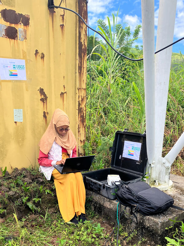
Technician from the Karthala Volcano Observatory downloading data from a seismic monitoring station, established by the USGS in Comoros.
Earthquake Hazard
The USGS Earthquake Hazards assistance Team (EDAT) responded to the September 2023 Morocco Earthquake by immediately sharing aftershock advisories and forecasts with Moroccan partners. EDAT also supported efforts to document the source characteristics of this significant damaging earthquake, to better understand how an enigmatic region of active surface faulting, and low seismicity produced significant damage and loss of life.
Formed in partnership among the USGS, the National Science Foundation (NSF) and EarthScope, the GSN provides near-uniform, worldwide monitoring of the Earth, with approximately 150 modern seismic stations distributed globally. GSN stations are operated by the USGS Albuquerque Seismological Laboratory, EarthScope, and other affiliate organizations.
Within Africa, GSN stations are located in Botswana, Cabo Verde, Côte d'Ivoire, Ethiopia, Kenya, Madagascar, Namibia, Seychelles, South Africa, Uganda, and Zambia.
USGS has had a long-term partnership with other US government agencies (NOAA, USDA, NASA) and NGOsto provide advance projections on drought and flood-related food shortages. The USGS provides expertise and training in satellite data acquisition, processing and interpretation with international partners in the Sahel and sub-Saharan regions of Africa.
The USGS FEWS NET Data Portal provides access to geo-spatial data, satellite image products, and derived data products in support of FEWS NET drought monitoring efforts throughout the world. This portal is provided by the USGS FEWS NET Project, part of the Early Warning Focus Area at the USGS Earth Resources Observation and Science (EROS) Center.
The USGS uses its 50+ years of Landsat satellite and other earth observation imagery to document changes on the landscape through time. In West Africa, the Sahel and Malawi, the USGS has worked with numerous international partner agencies to build local capacity to use and interpret this data. This work supports the monitoring of regional land use patterns and change, deforestation, desertification, and threats to biodiversity.
EROS in Action - Landscapes of West Africa
Gray Tappan and Francis Dwomoh discuss Landsat's contribution to the studies they have conducted regarding landscape changes in West Africa.
The USGS World Energy Project conducts geologic studies that provide an understanding of the quantity, quality, and geologic distribution of world oil and gas resources. Our geologic studies are conducted in an impartial manner and are performed in collaboration and partnership with energy experts within and outside government. Through synthesis and improved understanding of global oil and gas...
The USGS World Energy Project conducts geologic studies that provide an understanding of the quantity, quality, and geologic distribution of world oil and gas resources. Our geologic studies are conducted in an impartial manner and are performed in collaboration and partnership with energy experts within and outside government. Through synthesis and improved understanding of global oil and gas...
The purpose of the Program is to develop a sound understanding of the potential for development of potable groundwater supply in selected African countries and build local capacity to plan and conduct the hydrologic investigations and monitoring necessary to help ensure that groundwater resources are developed and managed efficiently and sustainably.
Africa Groundwater Exploration and Assessment Program
The purpose of the Program is to develop a sound understanding of the potential for development of potable groundwater supply in selected African countries and build local capacity to plan and conduct the hydrologic investigations and monitoring necessary to help ensure that groundwater resources are developed and managed efficiently and sustainably.
The US Geological Survey collaborated with Northern Arizona University and New Mexico State University in a project funded by the United States Agency for International Development-Kenya and East Africa Mission to investigate the use of satellite image data, along with hydrological and geological data sets, to research and develop maps of the potential of groundwater resources in southern Turkana...
Groundwater Exploration in Northwest Kenya, Turkana and Marsabit Counties: Groundwater Potential Mapping, Hydrogeology, Economic Assessment, and Capacity Building
The US Geological Survey collaborated with Northern Arizona University and New Mexico State University in a project funded by the United States Agency for International Development-Kenya and East Africa Mission to investigate the use of satellite image data, along with hydrological and geological data sets, to research and develop maps of the potential of groundwater resources in southern Turkana...
Landscapes of West Africa: A Window on a Changing World is an atlas and unique dataset that uses time-series satellite image data and field-based photography to tell the story of wide-ranging land change across 17 countries. EROS scientists selected the years 1975, 2000 and 2013 to characterize the landscapes and create the product, which represents the broadest effort to map the region in history...
Landscapes of West Africa: A Window on a Changing World
Landscapes of West Africa: A Window on a Changing World is an atlas and unique dataset that uses time-series satellite image data and field-based photography to tell the story of wide-ranging land change across 17 countries. EROS scientists selected the years 1975, 2000 and 2013 to characterize the landscapes and create the product, which represents the broadest effort to map the region in history...
This U.S. Geological Survey data release presents raster geospatial data of modeled estimates of average total annual evapotranspiration by groundwater (ETg) and recharge (RCH), in millimeters, for Kenya for 2000 through 2022. Estimates were calculated by differencing Climate Hazards Group InfraRed Precipitation with Stations (CHIRPS) 2.0 precipitation data and Moderate Resolution...
Ar/Ar data are for 12 samples that record the eruption age of tephra. The geochronology provides time constraints for the ages of tephra and interbedded sediments and fossils from Kenya and Ethiopia. Samples were collected by Erin Dimaggio (Pennsylvania State University), who brought them to the USGS Denver Argon Geochronology Laboratory for Ar/Ar analysis. Samples were analyzed in...
Cobalt, designated a critical mineral by the European Union and the United States, is a crucial component of the lithium-ion batteries found in cell phones, electric vehicles, and personal computing devices. Over half of the world’s cobalt supply is produced in the Democratic Republic of the Congo (DRC), where cobalt is mined in both large-scale and artisanal or small-scale operations...
This data release contains the boundaries of assessment units, assessment input data, and resulting fact sheet data tables for the assessment of undiscovered oil and gas resources in the offshore East Africa and Seychelles region. The Assessment Unit is the fundamental unit used in the National and Global Oil and Gas Assessment Project for the assessment of undiscovered oil and gas...
This data release catalogs the locations of small-scale diamond and gold mining dredges on the Kadéï (Sangha) River, Central African Republic from the years 2015 to 2019. The Kadéï river flows through the Nola prefecture in the CAR and is known to host placer diamond deposits. The dataset was developed through visual interpretation of 387 Synthetic Aperture Radar (SAR) scenes. The point...
USGS employees at a streamgage on the Limpopo River, Botswana
USGS employees John Lane (L) and Molly Wood (R) learning about field processes conducted at a streamgage on the Limpopo River near Mahalapye, Botswana.
USGS employees John Lane (L) and Molly Wood (R) learning about field processes conducted at a streamgage on the Limpopo River near Mahalapye, Botswana.
USGS employees visiting a managed aquifer recharge injection well in Botswana
USGS employees Molly Wood (L) and John Lane (R) visiting a managed aquifer recharge injection well pilot site operated by the Botswana Ministry of Land Management and Sanitation Services, Department of Water and Sanitation, Mahalapye, Botswana.
USGS employees Molly Wood (L) and John Lane (R) visiting a managed aquifer recharge injection well pilot site operated by the Botswana Ministry of Land Management and Sanitation Services, Department of Water and Sanitation, Mahalapye, Botswana.
Pull-up poster for USGS groundwater workshop in Nairobi, Kenya
Banner presenting the Tana and Athi River basin groundwater mapping project outside the Ministry of Water, Sanitation, and Irrigation (Maji House) in Nairobi, Kenya.
Banner presenting the Tana and Athi River basin groundwater mapping project outside the Ministry of Water, Sanitation, and Irrigation (Maji House) in Nairobi, Kenya.
USGS employees Molly Wood (3rd from left) and John Lane (3rd from right) with staff from the Namibia Ministry of Mines and Energy and the Ministry of Agriculture, Water, and Land Reform, after a workshop on geophysics data collection.
USGS employees Molly Wood (3rd from left) and John Lane (3rd from right) with staff from the Namibia Ministry of Mines and Energy and the Ministry of Agriculture, Water, and Land Reform, after a workshop on geophysics data collection.
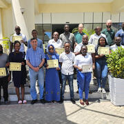
Trainees displaying their completion certificates from Capacity Building classes (Remote Sensing and Hydrogeology) at the Kenya School of Government, Mombasa, Kenya.
Trainees displaying their completion certificates from Capacity Building classes (Remote Sensing and Hydrogeology) at the Kenya School of Government, Mombasa, Kenya.
A well on the grounds of the Kenya School of Government in Mombasa
The hydrogeology training was held in August and September 2024 at the Kenya School of Government (KSG) in Mombasa. It covered the analysis of aquifer testing results and an introduction to groundwater and surface water field methods. The training consisted of a series of lectures and hands-on exercises.
The hydrogeology training was held in August and September 2024 at the Kenya School of Government (KSG) in Mombasa. It covered the analysis of aquifer testing results and an introduction to groundwater and surface water field methods. The training consisted of a series of lectures and hands-on exercises.
Trainees in the hydrogeology class in Mombasa, Kenya
The hydrogeology training was held in August and September 2024 at the Kenya School of Government (KSG) in Mombasa. It covered the analysis of aquifer testing results and an introduction to groundwater and surface water field methods. The training consisted of a series of lectures and hands-on exercises.
The hydrogeology training was held in August and September 2024 at the Kenya School of Government (KSG) in Mombasa. It covered the analysis of aquifer testing results and an introduction to groundwater and surface water field methods. The training consisted of a series of lectures and hands-on exercises.
The National University of Equatorial Guinea (UNGE) volcano monitoring team and collaborators
The UNGE team with a newly installed seismic station. Also pictured is Dr. Christine Sealing (Fulbright Specialist), top row second from left, and Aaron Rinehart (USAID-USGS VDAP) bottom row second from right.
The UNGE team with a newly installed seismic station. Also pictured is Dr. Christine Sealing (Fulbright Specialist), top row second from left, and Aaron Rinehart (USAID-USGS VDAP) bottom row second from right.
Introduction Africa is emerging as a leading source for minerals used in the manufacture of batteries for electric vehicles and in other renewable energy applications. New graphite, lithium, and rare-earth mines have or could be opened in African countries from 2017 through 2026. Estimates of production capacities for graphite, lithium, and rare-earth mines for 2023 and beyond are based...
Using a geology-based assessment methodology, the U.S. Geological Survey estimated undiscovered, technically recoverable mean resources of 5.1 billion barrels of oil and 79.1 trillion cubic feet of gas in offshore East Africa and the Seychelles.
Authors
Christopher J. Schenk, Tracey J. Mercier, Cheryl A. Woodall, Phuong A. Le, Andrea D. Cicero, Ronald M. Drake, Geoffrey S. Ellis, Thomas M. Finn, Michael H. Gardner, Sarah E. Gelman, Jane S. Hearon, Benjamin G. Johnson, Jenny H. Lagesse, Heidi M. Leathers-Miller, Kristen R. Marra, Kira K. Timm, Scott S. Young
Introduction In 2021, the U.S. Geological Survey's (USGS) National Minerals Information Center (NMIC) completed the project titled "Compilation of geospatial data for the mineral industries and related infrastructure of Africa." This project aimed to leverage the expertise and capabilities of the NMIC to collect, synthesize, and interpret geospatial data to inform on the extractive...
Authors
Elizabeth R. Neustaedter, Ryan F. Kemna, Abraham J. Padilla, Donya Otarod
Using a geology-based assessment methodology, the U.S. Geological Survey estimated undiscovered, technically recoverable mean conventional resources of 10.5 billion barrels of oil and 47.4 trillion cubic feet of gas in postsalt reservoirs within the West-Central Coastal Province of Africa.
Authors
Christopher J. Schenk, Tracey J. Mercier, Cheryl A. Woodall, Phuong A. Le, Andrea D. Cicero, Ronald M. Drake, Geoffrey S. Ellis, Thomas M. Finn, Michael H. Gardner, Sarah E. Gelman, Jane S. Hearon, Benjamin G. Johnson, Jenny H. Lagesse, Heidi M. Leathers-Miller, Kristen R. Marra, Kira K. Timm, Scott S. Young
Using a geology-based assessment methodology, the U.S. Geological Survey estimated undiscovered, technically recoverable mean conventional resources of 12.1 billion barrels of oil and 50 trillion cubic feet of gas in presalt reservoirs within the West-Central Coastal Province of Africa.
Authors
Christopher J. Schenk, Tracey J. Mercier, Cheryl A. Woodall, Phuong A. Le, Andrea D. Cicero, Ronald M. Drake, Geoffrey S. Ellis, Thomas M. Finn, Michael H. Gardner, Sarah E. Gelman, Jane S. Hearon, Benjamin G. Johnson, Jenny H. Lagesse, Heidi M. Leathers-Miller, Kristen R. Marra, Kira K. Timm, Scott S. Young
The U.S. Geological Survey (USGS) National Earthquake Information Center (NEIC) estimates source characteristics of significant damaging earthquakes, aiming to place events within their seismotectonic framework. Contextualizing the 8 September 2023, Mw 6.8 Al Haouz, Morocco, earthquake is challenging, because it occurred in an enigmatic region of active surface faulting, and low...
Authors
William L. Yeck, Alexandra Elise Hatem, Dara Elyse Goldberg, William D. Barnhart, Jessica Ann Thompson Jobe, David R. Shelly, Antonio Villasenor, Harley Benz, Paul S. Earle
The creation and expansion of protected areas, coupled with wildlife reintroductions, are increasingly used as conservation measures to combat wildlife declines worldwide. Although these types of restoration efforts are expected be beneficial to wildlife populations, variable species management and interactions among species within complex food webs have the potential to lead to...
Authors
Shannon K. Brewer, Lia Keener, Lourens H. Swanepoel, Craig Sholto-Douglas, Axel Hunnicutt, Goncalo Curveira-Santos
Using a geology-based assessment methodology, the U.S. Geological Survey estimated undiscovered, technically recoverable mean resources of 3.8 billion barrels of oil and 20.7 trillion cubic feet of gas offshore of Morocco.
Authors
Christopher J. Schenk, Tracey J. Mercier, Cheryl A. Woodall, Phuong A. Le, Andrea D. Cicero, Ronald M. Drake, Geoffrey S. Ellis, Thomas M. Finn, Michael H. Gardner, Sarah E. Gelman, Jane S. Hearon, Benjamin G. Johnson, Jenny H. Lagesse, Heidi M. Leathers-Miller, Kristen R. Marra, Kira K. Timm, Scott S. Young
From 2000 through 2020, demand for cobalt to manufacture batteries grew 26-fold. Eighty-two percent of this growth occurred in China and China’s cobalt refinery production increased 78-fold. Diminished industrial cobalt mine production in the early-to-mid 2000s led many Chinese companies to purchase ores from artisanal cobalt miners in the Democratic Republic of the Congo (DRC), many of...
Diamond and gold mining has been practiced by artisanal miners in the Central African Republic (CAR) for decades. The recent introduction of riverine dredges indicates a transition from artisanal/manual digging and sorting techniques to small-scale mining methods. This study implements a remote sensing analysis of Synthetic Aperture Radar (SAR) data to map gold and diamond dredges...
Authors
Marissa Ann Alessi, Peter G. Chirico, Sindhuja Sunder, Kelsey L. O’Pry
Ivory poaching continues to threaten African elephants. We (1) used criminology theory and literature evidence to generate hypotheses about factors that may drive, facilitate or motivate poaching, (2) identified datasets representing these factors, and (3) tested those factors with strong hypotheses and sufficient data quality for empirical associations with poaching. We advance on...
Authors
Timothy Kuiper, Res Altwegg, Colin Beale, Thea Carroll, Holy Dublin, Severin Hauenstein, Mrigesh Kshatriya, Carl Schwarz, Chris Thouless, Andy Royle, E.J. Milner-Gulland
Background Assemblages of mummified and preserved animals in necropoleis of Ptolemaic Period Egypt (ca. 332–30 BC) document some aspects of the ceremonial and religious practices of the ancient Egyptians, but study of these animal remains can also provide insight into the local environments in which the animals and humans lived.Results Excavations of the Sacred Falcon Necropolis at...
Tracking down commodity sources: The surprising role geoscience can play in assisting U.S. foreign policy
Since 2006, the USGS has collaborated with several international organizations working to track and monitor illegal mining and armed groups funded by...
Groundwater is a critical water resource for millions of people. This is particularly true in the arid and semi-arid regions of Kenya where rivers and...
Landsat Informing Better Wetland Management in Australia and Africa
Wetlands and mangroves are vital for climate change mitigation and adaptation, as they support flood control, pollution absorption, and carbon storage...
Landsat Helping to Address Food Security Challenges in Africa
Learning from the past and planning for the future. Using Earth observation products and tools in the fight to achieve global food security. This is...
Landsat Supporting Greater International Water Security
Looking to the past to protect the future: Landsat products and tools informing water security initiatives around the world. This is the second in a...
The USGS World Energy Project conducts geologic studies that provide an understanding of the quantity, quality, and geologic distribution of world oil and gas resources. Our geologic studies are conducted in an impartial manner and are performed in collaboration and partnership with energy experts within and outside government. Through synthesis and improved understanding of global oil and gas...
The USGS World Energy Project conducts geologic studies that provide an understanding of the quantity, quality, and geologic distribution of world oil and gas resources. Our geologic studies are conducted in an impartial manner and are performed in collaboration and partnership with energy experts within and outside government. Through synthesis and improved understanding of global oil and gas...
The purpose of the Program is to develop a sound understanding of the potential for development of potable groundwater supply in selected African countries and build local capacity to plan and conduct the hydrologic investigations and monitoring necessary to help ensure that groundwater resources are developed and managed efficiently and sustainably.
Africa Groundwater Exploration and Assessment Program
The purpose of the Program is to develop a sound understanding of the potential for development of potable groundwater supply in selected African countries and build local capacity to plan and conduct the hydrologic investigations and monitoring necessary to help ensure that groundwater resources are developed and managed efficiently and sustainably.
The US Geological Survey collaborated with Northern Arizona University and New Mexico State University in a project funded by the United States Agency for International Development-Kenya and East Africa Mission to investigate the use of satellite image data, along with hydrological and geological data sets, to research and develop maps of the potential of groundwater resources in southern Turkana...
Groundwater Exploration in Northwest Kenya, Turkana and Marsabit Counties: Groundwater Potential Mapping, Hydrogeology, Economic Assessment, and Capacity Building
The US Geological Survey collaborated with Northern Arizona University and New Mexico State University in a project funded by the United States Agency for International Development-Kenya and East Africa Mission to investigate the use of satellite image data, along with hydrological and geological data sets, to research and develop maps of the potential of groundwater resources in southern Turkana...
Landscapes of West Africa: A Window on a Changing World is an atlas and unique dataset that uses time-series satellite image data and field-based photography to tell the story of wide-ranging land change across 17 countries. EROS scientists selected the years 1975, 2000 and 2013 to characterize the landscapes and create the product, which represents the broadest effort to map the region in history...
Landscapes of West Africa: A Window on a Changing World
Landscapes of West Africa: A Window on a Changing World is an atlas and unique dataset that uses time-series satellite image data and field-based photography to tell the story of wide-ranging land change across 17 countries. EROS scientists selected the years 1975, 2000 and 2013 to characterize the landscapes and create the product, which represents the broadest effort to map the region in history...
This U.S. Geological Survey data release presents raster geospatial data of modeled estimates of average total annual evapotranspiration by groundwater (ETg) and recharge (RCH), in millimeters, for Kenya for 2000 through 2022. Estimates were calculated by differencing Climate Hazards Group InfraRed Precipitation with Stations (CHIRPS) 2.0 precipitation data and Moderate Resolution...
Ar/Ar data are for 12 samples that record the eruption age of tephra. The geochronology provides time constraints for the ages of tephra and interbedded sediments and fossils from Kenya and Ethiopia. Samples were collected by Erin Dimaggio (Pennsylvania State University), who brought them to the USGS Denver Argon Geochronology Laboratory for Ar/Ar analysis. Samples were analyzed in...
Cobalt, designated a critical mineral by the European Union and the United States, is a crucial component of the lithium-ion batteries found in cell phones, electric vehicles, and personal computing devices. Over half of the world’s cobalt supply is produced in the Democratic Republic of the Congo (DRC), where cobalt is mined in both large-scale and artisanal or small-scale operations...
This data release contains the boundaries of assessment units, assessment input data, and resulting fact sheet data tables for the assessment of undiscovered oil and gas resources in the offshore East Africa and Seychelles region. The Assessment Unit is the fundamental unit used in the National and Global Oil and Gas Assessment Project for the assessment of undiscovered oil and gas...
This data release catalogs the locations of small-scale diamond and gold mining dredges on the Kadéï (Sangha) River, Central African Republic from the years 2015 to 2019. The Kadéï river flows through the Nola prefecture in the CAR and is known to host placer diamond deposits. The dataset was developed through visual interpretation of 387 Synthetic Aperture Radar (SAR) scenes. The point...
USGS employees at a streamgage on the Limpopo River, Botswana
USGS employees John Lane (L) and Molly Wood (R) learning about field processes conducted at a streamgage on the Limpopo River near Mahalapye, Botswana.
USGS employees John Lane (L) and Molly Wood (R) learning about field processes conducted at a streamgage on the Limpopo River near Mahalapye, Botswana.
USGS employees visiting a managed aquifer recharge injection well in Botswana
USGS employees Molly Wood (L) and John Lane (R) visiting a managed aquifer recharge injection well pilot site operated by the Botswana Ministry of Land Management and Sanitation Services, Department of Water and Sanitation, Mahalapye, Botswana.
USGS employees Molly Wood (L) and John Lane (R) visiting a managed aquifer recharge injection well pilot site operated by the Botswana Ministry of Land Management and Sanitation Services, Department of Water and Sanitation, Mahalapye, Botswana.
Pull-up poster for USGS groundwater workshop in Nairobi, Kenya
Banner presenting the Tana and Athi River basin groundwater mapping project outside the Ministry of Water, Sanitation, and Irrigation (Maji House) in Nairobi, Kenya.
Banner presenting the Tana and Athi River basin groundwater mapping project outside the Ministry of Water, Sanitation, and Irrigation (Maji House) in Nairobi, Kenya.
USGS employees Molly Wood (3rd from left) and John Lane (3rd from right) with staff from the Namibia Ministry of Mines and Energy and the Ministry of Agriculture, Water, and Land Reform, after a workshop on geophysics data collection.
USGS employees Molly Wood (3rd from left) and John Lane (3rd from right) with staff from the Namibia Ministry of Mines and Energy and the Ministry of Agriculture, Water, and Land Reform, after a workshop on geophysics data collection.
Trainees displaying their completion certificates from Capacity Building classes (Remote Sensing and Hydrogeology) at the Kenya School of Government, Mombasa, Kenya.
Trainees displaying their completion certificates from Capacity Building classes (Remote Sensing and Hydrogeology) at the Kenya School of Government, Mombasa, Kenya.
A well on the grounds of the Kenya School of Government in Mombasa
The hydrogeology training was held in August and September 2024 at the Kenya School of Government (KSG) in Mombasa. It covered the analysis of aquifer testing results and an introduction to groundwater and surface water field methods. The training consisted of a series of lectures and hands-on exercises.
The hydrogeology training was held in August and September 2024 at the Kenya School of Government (KSG) in Mombasa. It covered the analysis of aquifer testing results and an introduction to groundwater and surface water field methods. The training consisted of a series of lectures and hands-on exercises.
Trainees in the hydrogeology class in Mombasa, Kenya
The hydrogeology training was held in August and September 2024 at the Kenya School of Government (KSG) in Mombasa. It covered the analysis of aquifer testing results and an introduction to groundwater and surface water field methods. The training consisted of a series of lectures and hands-on exercises.
The hydrogeology training was held in August and September 2024 at the Kenya School of Government (KSG) in Mombasa. It covered the analysis of aquifer testing results and an introduction to groundwater and surface water field methods. The training consisted of a series of lectures and hands-on exercises.
The National University of Equatorial Guinea (UNGE) volcano monitoring team and collaborators
The UNGE team with a newly installed seismic station. Also pictured is Dr. Christine Sealing (Fulbright Specialist), top row second from left, and Aaron Rinehart (USAID-USGS VDAP) bottom row second from right.
The UNGE team with a newly installed seismic station. Also pictured is Dr. Christine Sealing (Fulbright Specialist), top row second from left, and Aaron Rinehart (USAID-USGS VDAP) bottom row second from right.
Introduction Africa is emerging as a leading source for minerals used in the manufacture of batteries for electric vehicles and in other renewable energy applications. New graphite, lithium, and rare-earth mines have or could be opened in African countries from 2017 through 2026. Estimates of production capacities for graphite, lithium, and rare-earth mines for 2023 and beyond are based...
Using a geology-based assessment methodology, the U.S. Geological Survey estimated undiscovered, technically recoverable mean resources of 5.1 billion barrels of oil and 79.1 trillion cubic feet of gas in offshore East Africa and the Seychelles.
Authors
Christopher J. Schenk, Tracey J. Mercier, Cheryl A. Woodall, Phuong A. Le, Andrea D. Cicero, Ronald M. Drake, Geoffrey S. Ellis, Thomas M. Finn, Michael H. Gardner, Sarah E. Gelman, Jane S. Hearon, Benjamin G. Johnson, Jenny H. Lagesse, Heidi M. Leathers-Miller, Kristen R. Marra, Kira K. Timm, Scott S. Young
Introduction In 2021, the U.S. Geological Survey's (USGS) National Minerals Information Center (NMIC) completed the project titled "Compilation of geospatial data for the mineral industries and related infrastructure of Africa." This project aimed to leverage the expertise and capabilities of the NMIC to collect, synthesize, and interpret geospatial data to inform on the extractive...
Authors
Elizabeth R. Neustaedter, Ryan F. Kemna, Abraham J. Padilla, Donya Otarod
Using a geology-based assessment methodology, the U.S. Geological Survey estimated undiscovered, technically recoverable mean conventional resources of 10.5 billion barrels of oil and 47.4 trillion cubic feet of gas in postsalt reservoirs within the West-Central Coastal Province of Africa.
Authors
Christopher J. Schenk, Tracey J. Mercier, Cheryl A. Woodall, Phuong A. Le, Andrea D. Cicero, Ronald M. Drake, Geoffrey S. Ellis, Thomas M. Finn, Michael H. Gardner, Sarah E. Gelman, Jane S. Hearon, Benjamin G. Johnson, Jenny H. Lagesse, Heidi M. Leathers-Miller, Kristen R. Marra, Kira K. Timm, Scott S. Young
Using a geology-based assessment methodology, the U.S. Geological Survey estimated undiscovered, technically recoverable mean conventional resources of 12.1 billion barrels of oil and 50 trillion cubic feet of gas in presalt reservoirs within the West-Central Coastal Province of Africa.
Authors
Christopher J. Schenk, Tracey J. Mercier, Cheryl A. Woodall, Phuong A. Le, Andrea D. Cicero, Ronald M. Drake, Geoffrey S. Ellis, Thomas M. Finn, Michael H. Gardner, Sarah E. Gelman, Jane S. Hearon, Benjamin G. Johnson, Jenny H. Lagesse, Heidi M. Leathers-Miller, Kristen R. Marra, Kira K. Timm, Scott S. Young
The U.S. Geological Survey (USGS) National Earthquake Information Center (NEIC) estimates source characteristics of significant damaging earthquakes, aiming to place events within their seismotectonic framework. Contextualizing the 8 September 2023, Mw 6.8 Al Haouz, Morocco, earthquake is challenging, because it occurred in an enigmatic region of active surface faulting, and low...
Authors
William L. Yeck, Alexandra Elise Hatem, Dara Elyse Goldberg, William D. Barnhart, Jessica Ann Thompson Jobe, David R. Shelly, Antonio Villasenor, Harley Benz, Paul S. Earle
The creation and expansion of protected areas, coupled with wildlife reintroductions, are increasingly used as conservation measures to combat wildlife declines worldwide. Although these types of restoration efforts are expected be beneficial to wildlife populations, variable species management and interactions among species within complex food webs have the potential to lead to...
Authors
Shannon K. Brewer, Lia Keener, Lourens H. Swanepoel, Craig Sholto-Douglas, Axel Hunnicutt, Goncalo Curveira-Santos
Using a geology-based assessment methodology, the U.S. Geological Survey estimated undiscovered, technically recoverable mean resources of 3.8 billion barrels of oil and 20.7 trillion cubic feet of gas offshore of Morocco.
Authors
Christopher J. Schenk, Tracey J. Mercier, Cheryl A. Woodall, Phuong A. Le, Andrea D. Cicero, Ronald M. Drake, Geoffrey S. Ellis, Thomas M. Finn, Michael H. Gardner, Sarah E. Gelman, Jane S. Hearon, Benjamin G. Johnson, Jenny H. Lagesse, Heidi M. Leathers-Miller, Kristen R. Marra, Kira K. Timm, Scott S. Young
From 2000 through 2020, demand for cobalt to manufacture batteries grew 26-fold. Eighty-two percent of this growth occurred in China and China’s cobalt refinery production increased 78-fold. Diminished industrial cobalt mine production in the early-to-mid 2000s led many Chinese companies to purchase ores from artisanal cobalt miners in the Democratic Republic of the Congo (DRC), many of...
Diamond and gold mining has been practiced by artisanal miners in the Central African Republic (CAR) for decades. The recent introduction of riverine dredges indicates a transition from artisanal/manual digging and sorting techniques to small-scale mining methods. This study implements a remote sensing analysis of Synthetic Aperture Radar (SAR) data to map gold and diamond dredges...
Authors
Marissa Ann Alessi, Peter G. Chirico, Sindhuja Sunder, Kelsey L. O’Pry
Ivory poaching continues to threaten African elephants. We (1) used criminology theory and literature evidence to generate hypotheses about factors that may drive, facilitate or motivate poaching, (2) identified datasets representing these factors, and (3) tested those factors with strong hypotheses and sufficient data quality for empirical associations with poaching. We advance on...
Authors
Timothy Kuiper, Res Altwegg, Colin Beale, Thea Carroll, Holy Dublin, Severin Hauenstein, Mrigesh Kshatriya, Carl Schwarz, Chris Thouless, Andy Royle, E.J. Milner-Gulland
Background Assemblages of mummified and preserved animals in necropoleis of Ptolemaic Period Egypt (ca. 332–30 BC) document some aspects of the ceremonial and religious practices of the ancient Egyptians, but study of these animal remains can also provide insight into the local environments in which the animals and humans lived.Results Excavations of the Sacred Falcon Necropolis at...
Tracking down commodity sources: The surprising role geoscience can play in assisting U.S. foreign policy
Since 2006, the USGS has collaborated with several international organizations working to track and monitor illegal mining and armed groups funded by...
Groundwater is a critical water resource for millions of people. This is particularly true in the arid and semi-arid regions of Kenya where rivers and...
Landsat Informing Better Wetland Management in Australia and Africa
Wetlands and mangroves are vital for climate change mitigation and adaptation, as they support flood control, pollution absorption, and carbon storage...
Landsat Helping to Address Food Security Challenges in Africa
Learning from the past and planning for the future. Using Earth observation products and tools in the fight to achieve global food security. This is...
Landsat Supporting Greater International Water Security
Looking to the past to protect the future: Landsat products and tools informing water security initiatives around the world. This is the second in a...