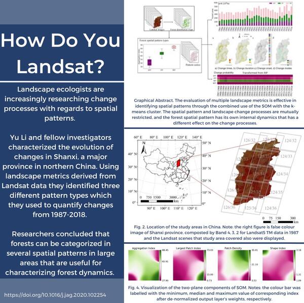
Landsat Updates are prepared periodically and distributed electronically to provide information about Landsat activities and related topics of interest.
Read more here: https://www.usgs.gov/landsat-missions/news/landsat-update-special-issue…
An official website of the United States government
Here's how you know
Official websites use .gov
A .gov website belongs to an official government organization in the United States.
Secure .gov websites use HTTPS
A lock () or https:// means you’ve safely connected to the .gov website. Share sensitive information only on official, secure websites.
Peruse our selection of remote sensing and Earth science imagery below.
Landsat Updates are prepared periodically and distributed electronically to provide information about Landsat activities and related topics of interest.
Read more here: https://www.usgs.gov/landsat-missions/news/landsat-update-special-issue…
Landsat Updates are prepared periodically and distributed electronically to provide information about Landsat activities and related topics of interest.
Read more here: https://www.usgs.gov/landsat-missions/news/landsat-update-special-issue…
The South American Savannas host several species, including ocelots and nutria rats. The soil is rich soil results in plantations of bananas, coffee, and other crops. Areas are cleared out for the fertile humus. The tropical Brazilian Cerrado is the largest savanna on the continent and the most threated biome from agricultural expansion.
With rapidly rising sea levels and drastically declining river discharge, the Changjiang Delta, near Shanghai, China, is continually evolving. Using Landsat imagery, researchers focused on tidal level fluctuations to help understand the changes to the largest uninhabited island in the estuary, Jiuduansha island.
The Operational Land Imager (OLI) onboard Landsat 8 captured this image of Lake Tahoe.
This map of the Cape Cod region is created with the National Land Cover Dataset (NLCD). The dataset classifies land cover into categories such as developed areas, forests, wetlands, and water bodies, providing a detailed view of the region's composition.
The Betsiboka River in Northern Madagascar is seen in this Landsat 9 natural color image from December 7, 2021. Extensive logging has left the land vulnerable, and iron rich soils are washed into the river, coloring it a reddish orange as it flows to the Betsiboka estuary delta.
Product ID LC09_L1TP_160071_20211207_20220120_02_T1
NASA and the USGS briefed the Landsat Science Team about Landsat 9 at their Fall Meeting held virtually on November 24, 2021.
Read the details here: https://www.usgs.gov/landsat-missions/news/landsat-science-team-virtual…
NASA and the USGS briefed the Landsat Science Team about Landsat 9 at their Fall Meeting held virtually on November 24, 2021.
Read the details here: https://www.usgs.gov/landsat-missions/news/landsat-science-team-virtual…
On Tuesday December 7, 2021, updates were made to all USGS webpages, including the Landsat Missions Web Site (LMWS).
Learn more here: https://www.usgs.gov/landsat-missions/news/landsat-mission-web-site-cha…
On Tuesday December 7, 2021, updates were made to all USGS webpages, including the Landsat Missions Web Site (LMWS).
Learn more here: https://www.usgs.gov/landsat-missions/news/landsat-mission-web-site-cha…
Deforestation can happen naturally, through infestation of native beetles and extreme weather. However, people can intentionally clear forests for timber and other industries. Difference between the two can be difficult to diagnose.
On November 23, 2021, the Landsat Archive added its ten millionth image. The Landsat 7 scene was acquired over the Dead Sea and is shown as a false color image using the short-wave infrared, near infrared and red bands (bands 5,4,3).
These images of an area in south central Queensland, Australia were acquired by the instruments onboard both Landsat 8 and Landsat 9 on November 15, 2021, as Landsat 9 flew beneath Landsat 8 as the satellite continued its climb to nominal orbital altitude.
Thick vegetation at a Guymon, Oklahoma, site required parking a quarter-mile away. The pickup is visible at the top center of the photo, which was taken on November 11, 2021, the first characterization day there. (Photo by Jeff Irwin, USGS)
Landsat 5 images of Zhuozhou, China, on September 7, 1999, showing top-of-atmosphere (TOA) reflectance; Level-2 surface reflectance (SR); and Level-2 surface temperature (ST), in Kelvin (K). View fact sheet at Landsat Collection 2 Level-2 Science Products (usgs.gov).
Landsat image of Window Rock, Arizona, acquired on November 3, 2021.
For more information about Landsat, please visit www.usgs.gov/Landsat
To download the data, visit earthexplorer.usgs.gov
Landsat image of Window Rock, Arizona, acquired on November 3, 2021.
For more information about Landsat, please visit www.usgs.gov/Landsat
To download the data, visit earthexplorer.usgs.gov
In the Western U.S., in places like the Navajo Nation as seen in this Landsat 9 image, Landsat and other satellite data help people monitor drought conditions and manage irrigation water. With only 85 rain gauges to cover more than 27,000 square miles, satellite data and climate models are filling the gaps to help the Navajo Nation monitor drought severity.
The city of Kathmandu, Nepal, seen at the bottom left of this Landsat 9 image, lies in a valley south of the Himalayan Mountainsbetween Nepal and China. Glaciers, and the lakes formed by glacial meltwater, are visible in the top middle of this image.
Sediments swirl in Lake Erie and Lake St. Clair in this Landsat 9 image of both Detroit, Michigan, and Windsor, Ontario, from Oct. 31, 2021. The Great Lakes serve as sources of freshwater, recreational activity, transport, and habitat for the upper-midwestern US, and water quality remains a high priority.
The EarthExplorer (EE) user interface is an online search, discovery, and ordering tool developed by the United States Geological Survey (USGS). EE supports the searching of satellite, aircraft, and other remote sensing inventories through interactive and textual-based query capabilities.
The Caldor Fire in California started on August 14, 2021 and quickly spread in high winds. The fire expanded toward the Lake Tahoe area as residents evacuated. Landsat image was captured on August 21, the 8th day. Landsat 8's near-infrared and shortwave infrared bands reveal active fire, burn scars, and smoke.