
A YSI Sontek M9 acoustic doppler current profiler (ADCP) measures the flow along the Sevenmile Canal. The Sevenmile Canal is a tributary to Upper Klamath Lake.
The USGS has been studying the Klamath Basin for decades. The USGS provides unbiased data to Tribal partners and resource managers to aid with complex management and conservation efforts.
The Klamath River Basin stretches from the mountains and valleys of south-central Oregon and northern California to the Pacific Ocean, spanning multiple climatic regions and a variety of ecosystems. Water quantity and quality are important topics in the basin. Water is a critical resource for farming and human needs, wildlife, aquatic ecosystems, and endangered species. USGS’s scientists and technicians study and monitor water resources in the basin to support Tribes, local and federal resource managers, and conservation needs.
The earliest studies on water resources by the USGS in the Klamath Basin go back to the early mid-twentieth century. The first stream gage in the area was installed in 1917 on the Williamson River, below Sprague River (11502500). USGS built upon these earlier efforts, with research and monitoring expanding rapidly since the 1990s. USGS research in the Klamath Basin spans many science topics related to surface-water quantity and quality, groundwater, sediment and nutrient transport, and geomorphology.
See the science tab for other related project web pages.
Below are science projects associated with the Klamath Basin.

Water Quality in Keno Reach of the Klamath River
The U.S. Geological Survey, U.S. Bureau of Reclamation, and Watercourse Engineering, Inc. are collaborating to develop knowledge and tools to better manage water quality in the Link-Keno reach of the Klamath River and the Lost River.

Nutrient and Sediment Loading to Upper Klamath Lake
The U.S. Geological Survey (USGS) computes time-series of total phosphorus (TP) and suspended-sediment concentrations (SSC) and loads entering Upper Klamath Lake using continuous turbidity sensor records, discrete TP and SSC data, and continuously computed streamflow.
Integrating water availability in the Klamath Basin: from drought to dam removal
The USGS Water Resources Mission Area is assessing how much water is available for human and ecological needs in the United States and identifying where and when the Nation may have challenges meeting its demand for water. This information helps decision makers manage and distribute water in ways that balance competing needs. Due to its complex and competing water demands, ecological significance...

Upper Klamath Basin Groundwater Studies
Since the late 1990s, USGS has worked to characterize the regional groundwater hydrology of the upper Klamath Basin. Research focuses on collecting data to evaluate the groundwater system and its response to external stresses, and to develop computer models that provide insights for water management. These efforts build on earlier USGS studies going back to the 1950s.

Klamath Dam Removal Studies
The USGS is collecting continuous and discrete monitoring data to document baseline conditions and physical responses in downstream river reaches before, during, and after dam removal. These monitoring data will be integral for post-removal assessments and collaborations with basin partners.

Vertical Hydraulic Gradient at the Sediment-Water Interface in Upper Klamath Lake
"The goal of this project is to characterize the vertical hydraulic gradient at the sediment-water interface in Upper Klamath Lake."

Upper Klamath River Basin Forecasts
"Determining water availability in the Upper Klamath Basin has always had a degree of uncertainty as a result of the complex hydrology and geology in the region and limited streamflow data."

Sediment Fingerprinting in the Upper Klamath Basin
Sediment fingerprinting has been used successfully to identify land uses that are the major sources of sediment. This study will apply these techniques in a predominantly rural, volcanic landscape.

Wood River Shoreline Management Tool
The Shoreline Management Tool is a geographic information system (GIS) based program developed to assist water- and land-resource managers in assessing the benefits and effects of changes in surface-water stage on water depth, inundated area, and water volume. Additionally, the Shoreline Management Tool can be used to identify aquatic or terrestrial habitat areas where conditions may be suitable...

Future Water Clarity and Dissolved Oxygen in Crater Lake
Warming air temperature may change water temperature and water column mixing in Oregon’s Crater Lake over the next several decades, potentially impacting the clarity and health of the iconic lake.

Geomorphology of the Sprague River Basin
The USGS documents historical and current channel and floodplain processes and conditions to assist management and regulatory agencies in evaluating restoration proposals and designing effective restoration and monitoring strategies for the Sprague River and its principle tributaries. The study involves multiple analyses, including assessments of historical channel change, riparian and floodplain...

Nutrient Loading to Lost River and Klamath River Subbasins
The USGS has characterized nutrient concentrations in the Klamath River and Lost River drainages over multiple years, identified spatial and temporal patterns in nutrient and organic carbon concentrations, and quantified surface water nutrient loads entering and exiting the Klamath Project.
Below are multimedia items associated with the Klamath Basin.

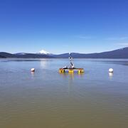
An ADCP measures the Sevenmile Canal
A YSI Sontek M9 acoustic doppler current profiler (ADCP) measures the flow along the Sevenmile Canal. The Sevenmile Canal is a tributary to Upper Klamath Lake.

Klamath Lake
View of Klamath Lake as seen by a USGS Hydrologic Technician in the field. Photo provided by Justin Willhite.
View of Klamath Lake as seen by a USGS Hydrologic Technician in the field. Photo provided by Justin Willhite.

Klamath River Basin Restoration
Dennis Lynch, USGS scientist and Department of Interior's Program Manager for the Klamath Basin Secretarial Determination, brings us up to speed on recent developments in the Klamath River Basin restoration.
Dennis Lynch, USGS scientist and Department of Interior's Program Manager for the Klamath Basin Secretarial Determination, brings us up to speed on recent developments in the Klamath River Basin restoration.
Below are news stories associated with the Klamath Basin.
A Warming Climate Could Alter the Ecology of the Deepest Lake in the United States A Warming Climate Could Alter the Ecology of the Deepest Lake in the United States
Warming air temperature is predicted to change water temperature and water column mixing in Oregon’s Crater Lake over the next several decades, potentially impacting the clarity and health of the iconic lake, according to a U.S. Geological Survey report released today.
Below are science projects associated with the Klamath Basin.
Water Quality in Keno Reach of the Klamath River
The U.S. Geological Survey, U.S. Bureau of Reclamation, and Watercourse Engineering, Inc. are collaborating to develop knowledge and tools to better manage water quality in the Link-Keno reach of the Klamath River and the Lost River.
Nutrient and Sediment Loading to Upper Klamath Lake
The U.S. Geological Survey (USGS) computes time-series of total phosphorus (TP) and suspended-sediment concentrations (SSC) and loads entering Upper Klamath Lake using continuous turbidity sensor records, discrete TP and SSC data, and continuously computed streamflow.
Integrating water availability in the Klamath Basin: from drought to dam removal
The USGS Water Resources Mission Area is assessing how much water is available for human and ecological needs in the United States and identifying where and when the Nation may have challenges meeting its demand for water. This information helps decision makers manage and distribute water in ways that balance competing needs. Due to its complex and competing water demands, ecological significance...
Upper Klamath Basin Groundwater Studies
Since the late 1990s, USGS has worked to characterize the regional groundwater hydrology of the upper Klamath Basin. Research focuses on collecting data to evaluate the groundwater system and its response to external stresses, and to develop computer models that provide insights for water management. These efforts build on earlier USGS studies going back to the 1950s.
Klamath Dam Removal Studies
The USGS is collecting continuous and discrete monitoring data to document baseline conditions and physical responses in downstream river reaches before, during, and after dam removal. These monitoring data will be integral for post-removal assessments and collaborations with basin partners.
Vertical Hydraulic Gradient at the Sediment-Water Interface in Upper Klamath Lake
"The goal of this project is to characterize the vertical hydraulic gradient at the sediment-water interface in Upper Klamath Lake."
Upper Klamath River Basin Forecasts
"Determining water availability in the Upper Klamath Basin has always had a degree of uncertainty as a result of the complex hydrology and geology in the region and limited streamflow data."
Sediment Fingerprinting in the Upper Klamath Basin
Sediment fingerprinting has been used successfully to identify land uses that are the major sources of sediment. This study will apply these techniques in a predominantly rural, volcanic landscape.
Wood River Shoreline Management Tool
The Shoreline Management Tool is a geographic information system (GIS) based program developed to assist water- and land-resource managers in assessing the benefits and effects of changes in surface-water stage on water depth, inundated area, and water volume. Additionally, the Shoreline Management Tool can be used to identify aquatic or terrestrial habitat areas where conditions may be suitable...
Future Water Clarity and Dissolved Oxygen in Crater Lake
Warming air temperature may change water temperature and water column mixing in Oregon’s Crater Lake over the next several decades, potentially impacting the clarity and health of the iconic lake.
Geomorphology of the Sprague River Basin
The USGS documents historical and current channel and floodplain processes and conditions to assist management and regulatory agencies in evaluating restoration proposals and designing effective restoration and monitoring strategies for the Sprague River and its principle tributaries. The study involves multiple analyses, including assessments of historical channel change, riparian and floodplain...
Nutrient Loading to Lost River and Klamath River Subbasins
The USGS has characterized nutrient concentrations in the Klamath River and Lost River drainages over multiple years, identified spatial and temporal patterns in nutrient and organic carbon concentrations, and quantified surface water nutrient loads entering and exiting the Klamath Project.
Below are multimedia items associated with the Klamath Basin.
An ADCP measures the Sevenmile Canal
A YSI Sontek M9 acoustic doppler current profiler (ADCP) measures the flow along the Sevenmile Canal. The Sevenmile Canal is a tributary to Upper Klamath Lake.
A YSI Sontek M9 acoustic doppler current profiler (ADCP) measures the flow along the Sevenmile Canal. The Sevenmile Canal is a tributary to Upper Klamath Lake.
Klamath Lake
View of Klamath Lake as seen by a USGS Hydrologic Technician in the field. Photo provided by Justin Willhite.
View of Klamath Lake as seen by a USGS Hydrologic Technician in the field. Photo provided by Justin Willhite.
Klamath River Basin Restoration
Dennis Lynch, USGS scientist and Department of Interior's Program Manager for the Klamath Basin Secretarial Determination, brings us up to speed on recent developments in the Klamath River Basin restoration.
Dennis Lynch, USGS scientist and Department of Interior's Program Manager for the Klamath Basin Secretarial Determination, brings us up to speed on recent developments in the Klamath River Basin restoration.
Below are news stories associated with the Klamath Basin.
A Warming Climate Could Alter the Ecology of the Deepest Lake in the United States A Warming Climate Could Alter the Ecology of the Deepest Lake in the United States
Warming air temperature is predicted to change water temperature and water column mixing in Oregon’s Crater Lake over the next several decades, potentially impacting the clarity and health of the iconic lake, according to a U.S. Geological Survey report released today.