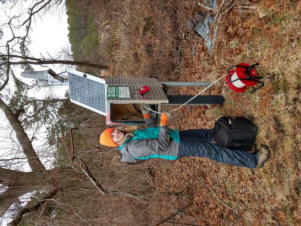
Scientists monitoring a shallow groundwater well in Los Planes watershed, Baja California Sur, Mexico. (Laura Norman, USGS)
How important is groundwater?
Groundwater, which is in aquifers below the surface of the Earth, is one of the Nation's most important natural resources. Groundwater is the source of about 37 percent of the water that county and city water departments supply to households and businesses (public supply). It provides drinking water for more than 90 percent of the rural population who do not get their water delivered to them from a county/city water department or private water company.
Even some major cities, such as San Antonio, Texas, rely solely on groundwater for all their needs. About 42 percent of the water used for irrigation comes from groundwater.
Withdrawals of groundwater are expected to rise as the population increases and available sites for surface reservoirs become more limited.
Learn more: Groundwater Use
Related
If the ground filters water, is groundwater always clean?
What is groundwater?
Where can I find detailed sampling methods for surface water and groundwater?
How frequently are volatile organic compounds (VOCs) detected in groundwater?
Where can I get my well water tested?
How can I find the depth to the water table in a specific location?
What is the Ground Water Atlas of the United States?
How much natural water is there?
How much water is used by people in the United States?

Scientists monitoring a shallow groundwater well in Los Planes watershed, Baja California Sur, Mexico. (Laura Norman, USGS)

Physical Scientist Shannon Fisher taking a water level measurement with a calibrated electric tape at the monthly discrete groundwater observation well located in Foster, Rhode Island
linkPhysical Scientist Shannon Fisher taking a water level measurement with a calibrated electric tape at the monthly discrete groundwater observation well located in Foster, Rhode Island. (Station ID#: 414420071422301 RI-FOW 40)
Winter 2024 Photo Contest: Sam Banas, Honorable Mention category

Conceptualization of the factors that affect groundwater recharge in oceanic islands.

A Geoscientist-in-the-Park Guest Scientist for the National Park Service services a USGS groundwater well located within the Mill Creek basin near the Herring River in Wellfleet, Massachusetts.
National Geodetic Survey vertical control bench mark W990 CADWR in Merced County, California. W 990 CADWR is on the Mariposa Bypass Bridge on Washington Rd. This is one of several bench mark locations used to help measure the largest recent subsidence in the area using repeat surveys.
National Geodetic Survey vertical control bench mark H1235 RESET in Merced County, California. H 1235 RESET is in the median of State Highway 15. This is one of several bench mark locations used to help measure the largest recent subsidence in the area using repeat surveys.

California's Central Valley Hydrologic Science
by Claudia Faunt, USGS Hydrologist
California's Central Valley Hydrologic Science
by Claudia Faunt, USGS Hydrologist

--issues facing current and future water supplies
by William Alley, USGS Office of Groundwater
--issues facing current and future water supplies
by William Alley, USGS Office of Groundwater
USGS employee sampling an urban groundwater well. Photo from USGS circular 1352 "Water quality in the Glacial Aquifer System, Northern United States, 1993 - 2009.

Irrigation water from a groundwater well on a rice crop field. Photo from USGS circular 1356 "Water Quality in the Mississippi Embayment-Texas Coastal Uplands Aquifer System and Mississippi River Valley Alluvial Aquifer, South-Central United States, 1994-2008."
Irrigation groundwater well. Photo from USGS circular 1356 "Water Quality in the Mississippi Embayment-Texas Coastal Uplands Aquifer System and Mississippi River Valley Alluvial Aquifer, South-Central United States, 1994-2008."
U.S. Geological Survey National Groundwater Climate Response Network
Availability of groundwater from the volcanic aquifers of the Hawaiian Islands
Estimated groundwater withdrawals from principal aquifers in the United States, 2015
Water priorities for the nation—The U.S. Geological Survey next generation water observing system
Estimated use of water in the United States in 2015
The quality of our Nation's waters: Water quality in principal aquifers of the United States, 1991-2010
Summary of estimated water use in the United States in 2010
Groundwater studies: principal aquifer surveys
Sustainability of ground-water resources
Ground water and surface water: A single resource
Ground water and the rural homeowner
Related
If the ground filters water, is groundwater always clean?
What is groundwater?
Where can I find detailed sampling methods for surface water and groundwater?
How frequently are volatile organic compounds (VOCs) detected in groundwater?
Where can I get my well water tested?
How can I find the depth to the water table in a specific location?
What is the Ground Water Atlas of the United States?
How much natural water is there?
How much water is used by people in the United States?

Scientists monitoring a shallow groundwater well in Los Planes watershed, Baja California Sur, Mexico. (Laura Norman, USGS)

Physical Scientist Shannon Fisher taking a water level measurement with a calibrated electric tape at the monthly discrete groundwater observation well located in Foster, Rhode Island
linkPhysical Scientist Shannon Fisher taking a water level measurement with a calibrated electric tape at the monthly discrete groundwater observation well located in Foster, Rhode Island. (Station ID#: 414420071422301 RI-FOW 40)
Winter 2024 Photo Contest: Sam Banas, Honorable Mention category
Physical Scientist Shannon Fisher taking a water level measurement with a calibrated electric tape at the monthly discrete groundwater observation well located in Foster, Rhode Island
linkPhysical Scientist Shannon Fisher taking a water level measurement with a calibrated electric tape at the monthly discrete groundwater observation well located in Foster, Rhode Island. (Station ID#: 414420071422301 RI-FOW 40)
Winter 2024 Photo Contest: Sam Banas, Honorable Mention category

Conceptualization of the factors that affect groundwater recharge in oceanic islands.

A Geoscientist-in-the-Park Guest Scientist for the National Park Service services a USGS groundwater well located within the Mill Creek basin near the Herring River in Wellfleet, Massachusetts.
National Geodetic Survey vertical control bench mark W990 CADWR in Merced County, California. W 990 CADWR is on the Mariposa Bypass Bridge on Washington Rd. This is one of several bench mark locations used to help measure the largest recent subsidence in the area using repeat surveys.
National Geodetic Survey vertical control bench mark H1235 RESET in Merced County, California. H 1235 RESET is in the median of State Highway 15. This is one of several bench mark locations used to help measure the largest recent subsidence in the area using repeat surveys.

California's Central Valley Hydrologic Science
by Claudia Faunt, USGS Hydrologist
California's Central Valley Hydrologic Science
by Claudia Faunt, USGS Hydrologist

--issues facing current and future water supplies
by William Alley, USGS Office of Groundwater
--issues facing current and future water supplies
by William Alley, USGS Office of Groundwater
USGS employee sampling an urban groundwater well. Photo from USGS circular 1352 "Water quality in the Glacial Aquifer System, Northern United States, 1993 - 2009.

Irrigation water from a groundwater well on a rice crop field. Photo from USGS circular 1356 "Water Quality in the Mississippi Embayment-Texas Coastal Uplands Aquifer System and Mississippi River Valley Alluvial Aquifer, South-Central United States, 1994-2008."
Irrigation groundwater well. Photo from USGS circular 1356 "Water Quality in the Mississippi Embayment-Texas Coastal Uplands Aquifer System and Mississippi River Valley Alluvial Aquifer, South-Central United States, 1994-2008."