U.S. flag

An official website of the United States government

Images

See our science through the images below.

Filter Total Items: 3512
Framework for critical mineral priorities
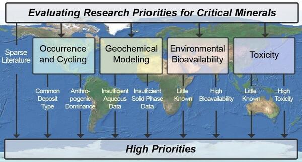
Framework for evaluating research priorities for critical minerals

Multidisciplinary Approach That Considers Occurrence, Geochemistry, Bioavailability, and Toxicity to Prioritize Critical Minerals for Environmental Research

Bison and elk feeding at the National Elk Refuge—Map inset
Bison and elk feeding at the National Elk Refuge with map inset showing land holdings of core elk range around refuge

Elk and bison being fed on the National Elk Refuge, Wyoming. Grand Teton and Grand Teton National Park are in the background. A map inset shows federal, state, and private land holdings of core winter elk range around the National Elk Refuge (labeled as the FWS unit). Map was generated by the USGS.

Map of winter elk range with labeled land holdings
Winter elk range land holdings around National Elk Refuge

Map showing federal, state, and private land holdings of core winter elk range around the National Elk Refuge (labeled as the FWS unit). Map was generated by the USGS. 

Map showing federal, state, and private land holdings of core winter elk range around the National Elk Refuge (labeled as the FWS unit). Map was generated by the USGS. 

Title slide for audio described version of EMA Friday's Findings webinar: Indigenous Knowledge - Insight into Climate Change
Friday's Findings: Indigenous Knowledge - Providing Insight into Climate Change (audio described) thumbnail

Ecosystems Mission Area Friday's Findings webinar; audio described version.  Indigenous Knowledge - Providing Insight into Climate Change.   Presented by Nicole Herman-Mercer, Southwest Climate Adaptation Science Center, on August 23, 2024.

Title slide for EMA Friday's Findings webinar: Indigenous Knowledge - Providing Insight into Climate Change
Friday's Findings: Indigenous Knowledge - Providing Insight into Climate Change thumbnail

Ecosystems Mission Area Friday's Findings webinar.   Indigenous Knowledge - Providing Insight into Climate Change.   Presented by Nicole Herman-Mercer, Southwest Climate Adaptation Science Center, on August 23, 2024.

A scientist wearing brown gloves holds a small bat while another scientist applies a vaccine to the bat with a small syringe.
Applying Vaccine to a Vampire Bat

USGS is developing and testing a safe rabies vaccine for vampire bats and conducting field studies for a practical delivery of this vaccine to wild populations of bats in the future. 

USGS is developing and testing a safe rabies vaccine for vampire bats and conducting field studies for a practical delivery of this vaccine to wild populations of bats in the future. 

Dark field microscope for microplastics
Dark field microscope image, microplastics

Dark field microscope from the manuscript, " a) A dark-field image of 1.5 µm PS LMMPs on a 0.4 μm PCTE membrane sensor. b) A Raman map of PS acquired by tracking its Raman band at 996 cm-1

Dark field microscope from the manuscript, " a) A dark-field image of 1.5 µm PS LMMPs on a 0.4 μm PCTE membrane sensor. b) A Raman map of PS acquired by tracking its Raman band at 996 cm-1

cryptozoologist coloring page
I Am A...Cryptozoologist (Coloring Page)

SPOOKY SCIENCE (and having some fun with a playful, silly, not real science career)

gif showing the contraction of the northern rubber boa's climate-niche
Northern rubber boa climate-niche shift

The northern rubber boa is an example of a species predicted to have a smaller climate-niche space by the end of the century. Under climate scenario RCP 8.5--which assumes carbon emissions stay near current levels--this species' range could be reduced from most of the northwestern U.S. to only a small portion of British Columbia.

The northern rubber boa is an example of a species predicted to have a smaller climate-niche space by the end of the century. Under climate scenario RCP 8.5--which assumes carbon emissions stay near current levels--this species' range could be reduced from most of the northwestern U.S. to only a small portion of British Columbia.

four people standing in a field of brown grass facing bare dirt hills, surrounded by equipment such as tarps and backpacks
Soil sampling in Colorado

A USGS field crew working on soil sampling, plant community monitoring, and soil water infiltration in the Colorado 'front range.'

A USGS field crew working on soil sampling, plant community monitoring, and soil water infiltration in the Colorado 'front range.'

a person crouches down in a field of brown grass and examines a blade of grass next to a white grid
Plant community monitoring in Colorado

A USGS scientist uses the grid-point intercept method to characterize plant communities in Larimer County, Colorado. The grid-point intercept method uses points along a grid to sample plant species or ground cover within a larger plot.

A USGS scientist uses the grid-point intercept method to characterize plant communities in Larimer County, Colorado. The grid-point intercept method uses points along a grid to sample plant species or ground cover within a larger plot.

a pile of soil on a blue tarp sitting next to a small hole marked by a red flag
Pit for sampling soil carbon

USGS scientists dig small ‘micro pits' to collect soil for testing. The team is careful to minimize the impact to the environment. Soil is stored on a tarp while sampling so it can be returned to the pit afterwards.

USGS scientists dig small ‘micro pits' to collect soil for testing. The team is careful to minimize the impact to the environment. Soil is stored on a tarp while sampling so it can be returned to the pit afterwards.

a person sitting in a field of brown grass holding a cylinder shaped device
Measuring soil water infiltration

A USGS scientist prepares a mini-disc infiltrometer to assess soil water infiltration. The degree to which water can infiltrate soil is closely tied to soil carbon content.

A USGS scientist prepares a mini-disc infiltrometer to assess soil water infiltration. The degree to which water can infiltrate soil is closely tied to soil carbon content.

a person kneels down in a field of brown grass and holds a blade of grass up to their face
Identifying grass species in Colorado

USGS scientists identifying plant community composition in Larimer County, Colorado. Information on plant community composition is critical for understanding differences in soil carbon-responses to exotic annual grass invasion between sites. 

USGS scientists identifying plant community composition in Larimer County, Colorado. Information on plant community composition is critical for understanding differences in soil carbon-responses to exotic annual grass invasion between sites. 

Was this page helpful?