
USGS Science Collaboration Portal for the Colorado River Basin
Collaboration platform that brings together science, data, and mapping and analytical tools from across the basin
Collaboration platform that brings together science, data, and mapping and analytical tools from across the basin
Colorado River Basin Actionable and Strategic Integrated Science and Technology (ASIST) Initiative
Fostering Innovative Interdisciplinary Science for Characterizing and Adapting to Long-term Drought
Fostering Innovative Interdisciplinary Science for Characterizing and Adapting to Long-term Drought
Colorado River Basin Drought and the 2023 Water Year
Geonarrative presentation comparing 2023 conditions to the long-term drought in the Colorado River Basin
Geonarrative presentation comparing 2023 conditions to the long-term drought in the Colorado River Basin
Great Salt Lake Data and Reports by the USGS
Learn about Water Quantity and Quality and Aquatic Ecology of this National Treasure
Learn about Water Quantity and Quality and Aquatic Ecology of this National Treasure
Colorado River Basin Studies in Utah
Learn about Surface Water, Groundwater Quantities and Quality and Artificial Recharge of Groundwater in the Colorado River Basin in Utah
Learn about Surface Water, Groundwater Quantities and Quality and Artificial Recharge of Groundwater in the Colorado River Basin in Utah
Streamflow in the Upper Rio Grande Basin
USGS Analyses of the Effects of Potential Future Climate Conditions on Streamflows in the Upper Rio Grande Basin
USGS Analyses of the Effects of Potential Future Climate Conditions on Streamflows in the Upper Rio Grande Basin
Next Generation Water Observing System (NGWOS) Study: Upper Colorado River Basin
The USGS NGWOS Program Provides Innovative, High-fidelity, Real-time Data and Insightful Analyses about Water Quantity, Quality, and Use in Selected Watersheds across the U.S.
The USGS NGWOS Program Provides Innovative, High-fidelity, Real-time Data and Insightful Analyses about Water Quantity, Quality, and Use in Selected Watersheds across the U.S.
Rocky Mountain Region
USGS Region 7 Staff support and advise USGS Science Centers that provide numerous stakeholders with vital information about spatial distribution and temporal trends in critical minerals, energy resources, geology, water resources, native plants and wildlife, and hazards posed by earthquakes and landslides in Colorado, New Mexico, Utah, Wyoming and beyond.
USGS Region 7: Upper Colorado Basin (Rocky Mountain)
USGS Region 7: Upper Colorado Basin (Rocky Mountain)

Map Showing USGS/DOI Unified Region 7 and adjoining Regions
Key USGS Region 7 Contacts
Key USGS Region 7 Contacts
Additional Information about USGS Region 7
Additional Information about USGS Region 7
News
New habitat suitability model to inform decision making and recover rare species in New Mexico
New habitat suitability model to inform decision making and recover rare species in New Mexico
2025 in Review: The Saline Lake Ecosystems Integrated Water Availability Assessment
2025 in Review: The Saline Lake Ecosystems Integrated Water Availability Assessment
Between a Rock and a Hard Place: Experiences of the Chronic Wasting Disease Management Community
Between a Rock and a Hard Place: Experiences of the Chronic Wasting Disease Management Community
Publications
Assessment of undiscovered conventional oil and gas resources in the Santos Basin, Campos Basin, and Espírito Santo Basin provinces of Brazil, 2024 Assessment of undiscovered conventional oil and gas resources in the Santos Basin, Campos Basin, and Espírito Santo Basin provinces of Brazil, 2024
Using a geology-based assessment methodology, the U.S. Geological Survey estimated undiscovered, technically recoverable mean conventional resources of 10.4 billion barrels of oil and 53.3 trillion cubic feet of gas in the Santos Basin, Campos Basin, and Espírito Santo Basin provinces of Brazil.
The petrogenesis of Þingmúli volcano, East Fjords; Iceland The petrogenesis of Þingmúli volcano, East Fjords; Iceland
In this work we revisit Þingmúli volcano (Þ = Th), a classic locality known as an example of a complete tholeiitic differentiation. Þingmúli is a ~ 9.5 Ma extinct central volcano located in the East Fjords of Iceland, in which the whole compositional spectrum from basalt to rhyolites have erupted. These volcanic products have been previously considered as petrogenetically related by an...
Out with the old: Empirical trends in U.S. land-based wind turbine decommissioning and repowering Out with the old: Empirical trends in U.S. land-based wind turbine decommissioning and repowering
A growing number of wind turbines (WTs) across the globe are now reaching or exceeding their expected service lifetime; WT decommissioning is on the rise. Accordingly, questions pertaining to WT end-of-life have risen in importance in policy and practice. Yet, research on the various factors relating to WT decommissioning is relatively sparse. Moreover, the key assumptions underpinning...
Science
AI-driven science synthesis tools for resource managers
The scientific literature is abundant on drought-related topics in the western United States, including areas of the Colorado River Basin and the sagebrush biome. Scientists, resource managers, and decision makers use this science to assess, predict, and respond to the effects of drought on people and the environment. However, it can be difficult to quickly synthesize large amounts of research. To...

USMIN Mineral Deposit Database
The USMIN Mineral Deposit Database Project develops national-scale geospatial databases that provide authoritative information on the most significant mines, mineral deposits, and mining districts in the United States. These resources advance the understanding of domestic mineral resources and are available through the output of digital data products, journal articles, presentations, and other...

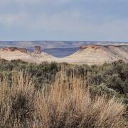
USGS Sagebrush Science: Supporting Public Safety and Economic Decision Making Across the West
The sagebrush biome is one of the largest ecosystems in North America. Encompassing nearly one-third of the continental U.S., it provides critical resources for millions of Americans and a home for hundreds of plants and animal species in the West. Natural resource management in sagebrush ecosystems can be complex, and science can support management decisions by providing knowledge and tools to...
By
Core Science Systems Mission Area, Ecosystems Mission Area, Biological Threats and Invasive Species Research Program, Climate Adaptation Science Centers, Cooperative Research Units, Land Change Science Program, Land Management Research Program, Species Management Research Program, Earth Resources Observation and Science (EROS) Center , Forest and Rangeland Ecosystem Science Center, Fort Collins Science Center, Northern Rocky Mountain Science Center, Southwest Biological Science Center, Western Ecological Research Center (WERC), Wildland Fire Science