This Landsat 8 image "Ice Vortex" is one of many beautiful images in the Earth as Art collections.
Visit https://eros.usgs.gov/media-gallery/earth-as-art to see more.

Official websites use .gov
A .gov website belongs to an official government organization in the United States.
Secure .gov websites use HTTPS
A lock () or https:// means you’ve safely connected to the .gov website. Share sensitive information only on official, secure websites.
Explore the images on this page to learn more about the Landsat sensors, satellites and missions.

This Landsat 8 image "Ice Vortex" is one of many beautiful images in the Earth as Art collections.
Visit https://eros.usgs.gov/media-gallery/earth-as-art to see more.
This Landsat 8 image "Ice Vortex" is one of many beautiful images in the Earth as Art collections.
Visit https://eros.usgs.gov/media-gallery/earth-as-art to see more.

This Landsat 8 image "Australian Iron Ore" is one of many beautiful images in the Earth as Art collections.
Visit https://eros.usgs.gov/media-gallery/earth-as-art to see more.
This Landsat 8 image "Australian Iron Ore" is one of many beautiful images in the Earth as Art collections.
Visit https://eros.usgs.gov/media-gallery/earth-as-art to see more.

Chesapeake Bay is the Nation's largest estuary and its restoration and protection is a priority. The USGS provides scientific information to help manage this vital ecosystem. As part of that role, staff at the USGS Earth Resources Observation and Science (EROS) Center created this true color composite image.
Chesapeake Bay is the Nation's largest estuary and its restoration and protection is a priority. The USGS provides scientific information to help manage this vital ecosystem. As part of that role, staff at the USGS Earth Resources Observation and Science (EROS) Center created this true color composite image.

Center pivot irrigation fields in the Arabian Desert are visible in this Landsat 8 image near Meegowa, Saudi Arabia. The image was acquired on Oct 10, 2018 and is shown in a color infrared band combination (Bands 5,4,3).
Center pivot irrigation fields in the Arabian Desert are visible in this Landsat 8 image near Meegowa, Saudi Arabia. The image was acquired on Oct 10, 2018 and is shown in a color infrared band combination (Bands 5,4,3).
Landsat 8 image - Earth as Art "Tapestry"
View the entire image at https://eros.usgs.gov/media-gallery/earth-as-art/5/tapestry
Landsat 8 image - Earth as Art "Tapestry"
View the entire image at https://eros.usgs.gov/media-gallery/earth-as-art/5/tapestry

This image titled "Bleeding Heart" is one of many contained in the 5th Earth as Art collection.
Visit https://eros.usgs.gov/media-gallery/earth-as-art to view the entire group of Earth as Art collections.
This image titled "Bleeding Heart" is one of many contained in the 5th Earth as Art collection.
Visit https://eros.usgs.gov/media-gallery/earth-as-art to view the entire group of Earth as Art collections.

Example of Landsat Provisional Surface Temperature over the Yellowstone Lake area. Landsat 5 image acquired on September 11, 2018.
Example of Landsat Provisional Surface Temperature over the Yellowstone Lake area. Landsat 5 image acquired on September 11, 2018.

Citation: Citation_Information: Originator: U.S.
Citation: Citation_Information: Originator: U.S.

Left: Landsat 8 Collection 1 Top of Atmosphere reflectance image (bands 4,3,2) and Right: Landsat 8 Collection 1 atmospherically corrected surface reflectance image for an area over Los Angeles, California, path 41 row 36 acquired on August 31, 2018.
Left: Landsat 8 Collection 1 Top of Atmosphere reflectance image (bands 4,3,2) and Right: Landsat 8 Collection 1 atmospherically corrected surface reflectance image for an area over Los Angeles, California, path 41 row 36 acquired on August 31, 2018.

Landsat Dynamic Surface Water Extent Science Product example from Northern Minnesota.
Landsat Dynamic Surface Water Extent Science Product example from Northern Minnesota.

Landsat 5 captured this image of the Tampa Bay, Florida area on March 22, 1991.
Bands 7,2,1
Image processed at Center for Coastal Geology, St. Petersburg, Florida.
Landsat 5 captured this image of the Tampa Bay, Florida area on March 22, 1991.
Bands 7,2,1
Image processed at Center for Coastal Geology, St. Petersburg, Florida.

Example of Landsat Provisional Actual Evapotranspiration (ETa) product near the Colorado/Nebraska border near the Platte River.
Example of Landsat Provisional Actual Evapotranspiration (ETa) product near the Colorado/Nebraska border near the Platte River.

Example of Landsat Provisional Actual Evapotranspiration for agricultural fields near Sterling, Colorado in the South Platte Basin, using data acquired by Landsat 8 (Path 32 Row 32) on July 31, 2018; Left: Natural Color Surface Reflectance Image, Right: Actual Evapotranspiration Image.
Example of Landsat Provisional Actual Evapotranspiration for agricultural fields near Sterling, Colorado in the South Platte Basin, using data acquired by Landsat 8 (Path 32 Row 32) on July 31, 2018; Left: Natural Color Surface Reflectance Image, Right: Actual Evapotranspiration Image.

The Landsat archive has added its 8 millionth scene. This stunning image was captured by Landsat 8 on July 28, 2018. It shows the coastline of Nordaustlandet, the second-largest island in Norway’s Svalbard archipelago.
The Landsat archive has added its 8 millionth scene. This stunning image was captured by Landsat 8 on July 28, 2018. It shows the coastline of Nordaustlandet, the second-largest island in Norway’s Svalbard archipelago.

This image showing the Black Hills and Badlands, South Dakota is a mosaic of multiple Landsat 8 scenes acquired in 2015 and 2016.
This image showing the Black Hills and Badlands, South Dakota is a mosaic of multiple Landsat 8 scenes acquired in 2015 and 2016.

The Lake Eyre Basin is one of the driest places in Australia. But this image features a rare green flush to this otherwise parched landscape. Streams and creeks that drain into the basin are usually dry, but storms in March 2018 delivered water to these braided channels. By April, the floodwater had receded and left a green expanse behind.
The Lake Eyre Basin is one of the driest places in Australia. But this image features a rare green flush to this otherwise parched landscape. Streams and creeks that drain into the basin are usually dry, but storms in March 2018 delivered water to these braided channels. By April, the floodwater had receded and left a green expanse behind.

Imagery collected over Antarctica by satellites like Landsat is typically marked by highly reflective snow and ice, but isolated pockets of wind-swept glacial ice glow with a distinct blue.
Imagery collected over Antarctica by satellites like Landsat is typically marked by highly reflective snow and ice, but isolated pockets of wind-swept glacial ice glow with a distinct blue.

Ivanpah Playa Radiometric Calibration Site
Learn more about this Test Site at https://calval.cr.usgs.gov/apps/ivanpah.
Ivanpah Playa Radiometric Calibration Site
Learn more about this Test Site at https://calval.cr.usgs.gov/apps/ivanpah.

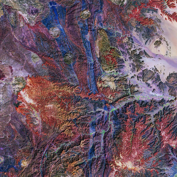
Soft colors contrast with harsh terrain in southwestern Saudi Arabia, near the border with Yemen. Calming blues and purples seem to collide with an angry orange in this rich tapestry of colors, which are the result of the region’s complex geology. The wild shapes in this busy landscape lie in a region known as the Asharah fault zone.
Soft colors contrast with harsh terrain in southwestern Saudi Arabia, near the border with Yemen. Calming blues and purples seem to collide with an angry orange in this rich tapestry of colors, which are the result of the region’s complex geology. The wild shapes in this busy landscape lie in a region known as the Asharah fault zone.

Artist's concept of Landsat 8 orbting the Earth.
Image Credit: NASA Goddard Space Flight Center
Artist's concept of Landsat 8 orbting the Earth.
Image Credit: NASA Goddard Space Flight Center

In September 2017, Landsat 8's Operational Land Imager (OLI) Landsat 8 captured this image of a large phytoplankton bloom in Lake Erie, near Toledo, Ohio.
In September 2017, Landsat 8's Operational Land Imager (OLI) Landsat 8 captured this image of a large phytoplankton bloom in Lake Erie, near Toledo, Ohio.