
This image of Michigan’s Upper Peninsula was captured by the Multispectral Scanner (MSS) instrument onboard the Landsat 5 satellite on January 7, 2013.
Images
Explore the images on this page to learn more about the Landsat sensors, satellites and missions.
Filter Total Items: 413

Landsat 5 MSS Image of Michigan’s Upper Peninsula
This image of Michigan’s Upper Peninsula was captured by the Multispectral Scanner (MSS) instrument onboard the Landsat 5 satellite on January 7, 2013.

Brown Marsh in Southeast Louisiana
Brown Marsh observed in southeastern Terrebonne Basin, La
Brown Marsh observed in southeastern Terrebonne Basin, La

Tile drain in intensive Corn Belt agriculture
A tile drain concentrates and transports irrigation water and the chemicals it contains to a stream.
A tile drain concentrates and transports irrigation water and the chemicals it contains to a stream.

Landsat 5 Captures MSS Data
The Multispectral Scanner (MSS) on board Landsat 5 satellite captured imagery of the southern Louisiana coastline on April 10, 2012, after the sensor was turned back on after being off for nearly a dozen years. This image is a portion of the scene from WRS-2 Path 23 Row 40. The MSS sensor collected nearly 15,000 scenes from 2012 to January 7, 2013.
The Multispectral Scanner (MSS) on board Landsat 5 satellite captured imagery of the southern Louisiana coastline on April 10, 2012, after the sensor was turned back on after being off for nearly a dozen years. This image is a portion of the scene from WRS-2 Path 23 Row 40. The MSS sensor collected nearly 15,000 scenes from 2012 to January 7, 2013.
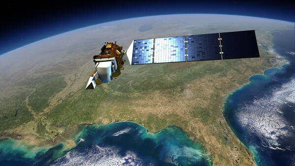
Image of Landsat 8 over the US
This illustration shows the Landsat 8 satellite in space over the southeastern United States.
This illustration shows the Landsat 8 satellite in space over the southeastern United States.

Tuscaloosa-Birmingham Tornado Scar, April 2011
The roughly west-east trail of destruction from the April 27, 2011, Tuscaloosa-Birmingham tornado is clearly visible in these Landsat images. This was one of 358 recorded tornadoes during the April 25-28, 2011, tornado outbreak, the most severe in U.S. history.
The roughly west-east trail of destruction from the April 27, 2011, Tuscaloosa-Birmingham tornado is clearly visible in these Landsat images. This was one of 358 recorded tornadoes during the April 25-28, 2011, tornado outbreak, the most severe in U.S. history.

Example of the Landsat Collection 2 Fractional Snow Covered Snow Science Product
Example of the Landsat Collection 2 Fractional Snow Covered Snow Science ProductExample of the Landsat Collection 2 Fractional Snow Covered Area (fSCA) Science Product showing an area in the Dixie National Forest in Utah on February 28, 2021 for tile h007V010. Left: Landsat Collection 2 U.S. Analysis Ready Data Surface Reflectance image, Middle: fSCA, and Right: Canopy Adjusted fSCA.

Landsat 5 image of Gascoyne, Australia
Landsat 5 image of Gascoyne, West Australia. The image was acquired on December 12, 2010.
Learn more about Landsat at www.usgs.gov/landsat
Landsat 5 image of Gascoyne, West Australia. The image was acquired on December 12, 2010.
Learn more about Landsat at www.usgs.gov/landsat

Example of Landsat Collection 2 Surface Temperature
Example of Landsat Collection 2 Surface TemperatureExample of Landsat Collection 2 Surface Temperature over the Tacoma, Washington area. Landsat 5 image aquired on October 6, 2010.
Example of Landsat Collection 2 Surface Temperature
Example of Landsat Collection 2 Surface TemperatureExample of Landsat Collection 2 Surface Temperature over the Tacoma, Washington area. Landsat 5 image aquired on October 6, 2010.

Landsat 5 image showing the Seattle, Washington area
Landsat 5 image showing the Seattle, Washington areaExample of the Landsat 4-5 TM Collection 2 level-1 product. This Landsat 5 image was acquired on October 6, 2010 near Seattle, Washington and is shown as a natural color composite using the red, green, and blue bands (bands 3,2,1).

Landsat Collection 2 Sample Data Example
Landsat 5 Thematic Mapper (TM) Collection 2 sample data example
Bands 5,4,3
Landsat 5 Thematic Mapper (TM) Collection 2 sample data example
Bands 5,4,3

Example of the Landsat Collection 2 Surface Reflectance product
Example of the Landsat Collection 2 Surface Reflectance productExample of the Landsat Collection 2 Level-2 Surface Reflectance science product over Seattle, Washington. Landsat 5 image acquired Oct 6, 2010 (bands 4,3,2)
Example of the Landsat Collection 2 Surface Reflectance product
Example of the Landsat Collection 2 Surface Reflectance productExample of the Landsat Collection 2 Level-2 Surface Reflectance science product over Seattle, Washington. Landsat 5 image acquired Oct 6, 2010 (bands 4,3,2)

Example of the Landsat 4-5 TM Collection 2 level-2 science products
Example of the Landsat 4-5 TM Collection 2 level-2 science productsExample of the Landsat 4-5 TM Collection 2 level-2 science products. Left: Landsat 5 level-2 surface reflectance image. Right: Landsat 5 level-2 surface temperature image. The data was acquired on October 6, 2010 (path 47 row 27).

Example of Landsat 5 Collection 2
Example of Landsat 5 Collection 2 data over Bremerton, WA. acquired on October 6, 2010. Left: Level 1 data, middle: Level-2 surface reflectance, right: Level-2 surface temperature.
Example of Landsat 5 Collection 2 data over Bremerton, WA. acquired on October 6, 2010. Left: Level 1 data, middle: Level-2 surface reflectance, right: Level-2 surface temperature.

Sheridan Glacier from the Air
Sheridan glacier and Sheridan river from the air, rich in fine glacial flour.
Sheridan glacier and Sheridan river from the air, rich in fine glacial flour.

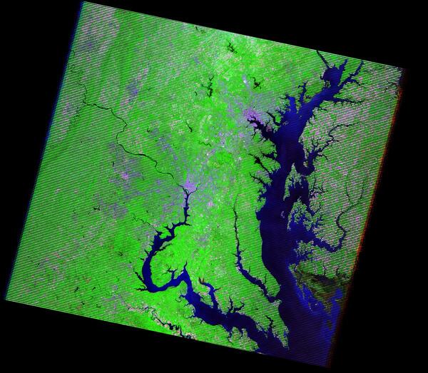
Landsat 7 Image of Washington DC and Baltimore area
Landsat 7 Image of Washington DC and Baltimore areaThis Landsat 7 image captures the Washington, D.C., and Baltimore, MD, areas. Washington, D.C., lies in the center of the image along the Potomac River. Baltimore, in the upper-right portion of the image, is located on the western shore of Chesapeake Bay.

Farmland near Hydetown, PA
Farmland near Hydetown, Pennsylvania, part of the Erie Drift Plain Ecoregion. This photo was taken during fieldwork for the USGS Land Cover Trends project. The project was focused on understanding the rates, trends, causes, and consequences of contemporary U.S.
Farmland near Hydetown, Pennsylvania, part of the Erie Drift Plain Ecoregion. This photo was taken during fieldwork for the USGS Land Cover Trends project. The project was focused on understanding the rates, trends, causes, and consequences of contemporary U.S.

Landsat 7 image showing the area near Ciudad Obregón, Mexico
Landsat 7 image showing the area near Ciudad Obregón, MexicoExample of the Landsat 7 ETM+ Collection 2 level-1 product. This Landsat 7 image was acquired on January 1, 2003 near Ciudad Obregón, Mexico and is shown as a natural color composite using the red, green, and blue bands (bands 3,2,1).
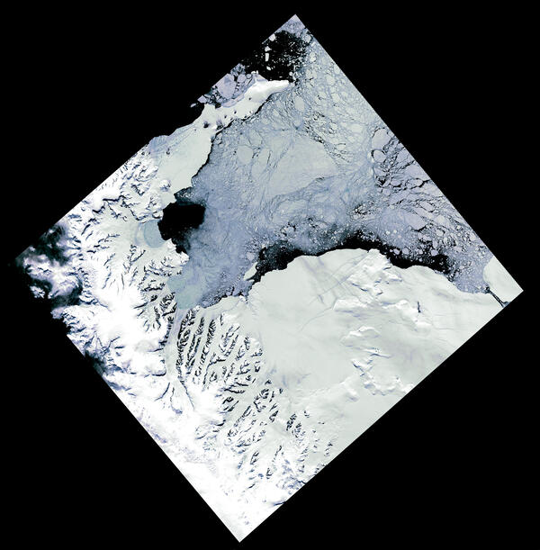
Landsat image of the Larsen B Ice Shelf after its collapse
Landsat image of the Larsen B Ice Shelf after its collapseThis natural color pan sharpened Landsat 7 image from December 18, 2002 shows the remnant or the Larsen B ice shelf after its collapse at the beginning of the year. Landsat’s detailed observations help scientists track changes in ice stability over time.

Comparison of Landsat 5 and Landsat 7 Thermal Resolution Near Alliance, Nebraska
Comparison of Landsat 5 and Landsat 7 Thermal Resolution Near Alliance, NebraskaThis graphic highlights the difference in thermal band resolution between Landsat 5 and Landsat 7, focusing on center pivot irrigation fields near Alliance, Nebraska. The Landsat 5 image (top), taken on July 3, 2002, has a coarser 120-meter resolution, while the Landsat 7 image (bottom), from July 2, 2002, offers greater detail with its 60-meter resolution.