
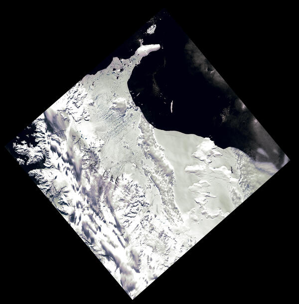
This natural-color, pan-sharpened Landsat image from December 31, 2001, shows the Larsen B Ice Shelf along the Antarctic Peninsula just a few months before its historic breakup. Blue meltwater pools can be seen on the shelf. Landsat’s detailed observations help scientists track changes in ice stability over time.
Images
Explore the images on this page to learn more about the Landsat sensors, satellites and missions.
Filter Total Items: 413
Landsat Image of Larsen B Ice Shelf
This natural-color, pan-sharpened Landsat image from December 31, 2001, shows the Larsen B Ice Shelf along the Antarctic Peninsula just a few months before its historic breakup. Blue meltwater pools can be seen on the shelf. Landsat’s detailed observations help scientists track changes in ice stability over time.

Landsat Image Mosaic of Antarctica (LIMA)
In stunning detail, the Landsat Image Mosaic of Antarctica (LIMA) brings Antarctica to life, both for the scientific community and the general public.
In stunning detail, the Landsat Image Mosaic of Antarctica (LIMA) brings Antarctica to life, both for the scientific community and the general public.

Center-pivot irrigation in Saudi Arabia captured by Landsat 7, 2000
Center-pivot irrigation in Saudi Arabia captured by Landsat 7, 2000Landsat 7 captured this image of center-pivot irrigation (green circles) in the Saudi Arabian desert in 2000. Images taken of the same location over several decades show the explosive increase of irrigated land over time, as hidden reserves of water have been tapped beneath desert sands to grow grains, fruits, and vegetables.
Landsat 7 Image of Eyjabakkajökull Glacier
This Landsat image displays the Eyjabakkajökull Glacier, an outlet glacier of the Vatnajökull ice cap in Iceland. (N64.6756, W15.5843)
Landsat 7 Path 216 Row 15
Acquired September 16, 2000
This Landsat image displays the Eyjabakkajökull Glacier, an outlet glacier of the Vatnajökull ice cap in Iceland. (N64.6756, W15.5843)
Landsat 7 Path 216 Row 15
Acquired September 16, 2000

Landsat Image Mosaic Of Antarctica (LIMA) Mosaic
Landsat 7 imagery was used to create a full continent mosaic of Antarctica.
Landsat 7 imagery was used to create a full continent mosaic of Antarctica.

1999 Landsat 7 Launch
Landsat 7 was successfully launched on April 15, 1999, from the Western Test Range of Vandenberg Air Force Base, California, on a Delta II expendable launch vehicle. EROS History Project
Landsat 7 was successfully launched on April 15, 1999, from the Western Test Range of Vandenberg Air Force Base, California, on a Delta II expendable launch vehicle. EROS History Project

Landsat 7 Sees Coral Reefs around Upolu Island Samoa
Landsat 7 Sees Coral Reefs around Upolu Island SamoaLandsat 7 captured this image of Upolu Island in Samoa in July of 1999. The coral reefs around Upolu and surrounding islands have been studied for longevity. Coral reefs around the island are virtually continuous, forming an extensive shallow reef flat. Landsat 7 July 6, 1999.
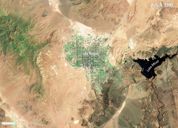
Las Vegas, 1999
This Landsat 7 image of the Las Vegas area, acquired on July 4, 1999, is the first image captured of this region by the satellite. The image prominently features the city of Las Vegas. It also shows Lake Mead, the largest reservoir in the United States, along with the surrounding desert landscape.
This Landsat 7 image of the Las Vegas area, acquired on July 4, 1999, is the first image captured of this region by the satellite. The image prominently features the city of Las Vegas. It also shows Lake Mead, the largest reservoir in the United States, along with the surrounding desert landscape.

Landsat 7 Underfly Image with Landsat 5
Landsat 7 underfly with Landsat 5 over the Niobrara River, Nebraska on June 2, 1999. The left image shows the Landsat 5 TM image and the right image is from Landsat 7 ETM+. Both images are shown as a false color image using the near infrared, red, and green bands (Bands 4|3|2).
Landsat 7 underfly with Landsat 5 over the Niobrara River, Nebraska on June 2, 1999. The left image shows the Landsat 5 TM image and the right image is from Landsat 7 ETM+. Both images are shown as a false color image using the near infrared, red, and green bands (Bands 4|3|2).

Lake Carnegie
Ephemeral Lake Carnegie, in Western Australia, fills with water only during periods of significant rainfall. In dry years, it is reduced to a muddy marsh.
Ephemeral Lake Carnegie, in Western Australia, fills with water only during periods of significant rainfall. In dry years, it is reduced to a muddy marsh.

First Landsat 7 image of Sioux Falls, South Dakota
First Landsat 7 image of Sioux Falls, South DakotaThis pan sharpened color infrared image of Sioux Falls, South Dakota is from the first scene acquired by Landsat 7's Enhanced Thematic Mapper Plus (ETM+) sensor on April 18, 1999. The image is shown using the near infrared, red, and green bands (Bands 4,3,2).

Landsat 5 Image of the Great Salt Lake in July, 1986
Landsat 5 Image of the Great Salt Lake in July, 1986Natural color Landsat 5 image of the Great Salt Lake acquired on July 1, 1986. In 1986, the lake was at a record high and covered approximately 2,300 square miles and contained 30 million acre-feet of water (an acre-foot is the amount of water necessary to cover 1 acre of land with water 1 foot in depth or about 326,000 gallons).

Landsat 5 Underfly with Landsat 4 over Huntsville, Alabama
Landsat 5 Underfly with Landsat 4 over Huntsville, AlabamaShowing images acquired over Huntsville, Alabama during the Landsat 5 underfly with Landsat 4. On the top is the Landsat 4 TM image, and on the bottom is the Landsat 5 TM image. Both image composites are shown as a natural color composite using the red, green, and blue bands (Bands 3|2|1)

Landsat 5 First Light Image of Lake Superior
One of the first clear Landsat 5 images shows an icy Lake Superior, northern Minnesota, and the Wisconsin's Apostle Islands. The Thematic Mapper (TM) image is shown as a false color composite using the near infrared, red and green bands (bands 4,3,2) and was acquired on March 6, 1984, just 5 days after the launch.
One of the first clear Landsat 5 images shows an icy Lake Superior, northern Minnesota, and the Wisconsin's Apostle Islands. The Thematic Mapper (TM) image is shown as a false color composite using the near infrared, red and green bands (bands 4,3,2) and was acquired on March 6, 1984, just 5 days after the launch.

Landsat 5 First Light Image over South Texas Gulf Coast
Landsat 5 First Light Image over South Texas Gulf CoastOne of the first Landsat 5 images in the archive shows Corpus Christi and Padre Island National Seashore. The image was acquired on March 6, 1984 and is shown as a false color composite using the near infrared, red, and green bands (bands 4,3,2).
Learn more about the mission on the Landsat 5 web page

Landsat 5 First Light Image of Corpus Christi, Texas
Landsat 5 First Light Image of Corpus Christi, TexasOn March 6, 1984, the Thematic Mapper (TM) on Landsat 5 captured this image of Corpus Christi. Texas. Located in South Texas on the Gulf of America, the city and its bay are protected by barrier islands.

Landsat 4 First Light Image over western Lake Erie
Landsat 4 First Light Image over western Lake ErieLandsat 4's first light image captured eastern Lake Erie, and the cities of Toledo, Detroit, and Windsor on July 25, 1982. Although the Landsat program had been collecting images of the Earth since 1972, this was the first time that the data could be depicted as a natural color image due to the new Thematic Mapper sensor onboard Landsat 4.

Landsat 4 First Light Image of Detroit
The first Landsat 4 image was acquired over western Lake Erie on July 25, 1982, just 9 days after launch. This image shows the Detroit River dividing the metropolitan areas of Detroit, Michigan and Windsor, Ontario while acting as a strait between Lake Erie and Lake St. Clair.
The first Landsat 4 image was acquired over western Lake Erie on July 25, 1982, just 9 days after launch. This image shows the Detroit River dividing the metropolitan areas of Detroit, Michigan and Windsor, Ontario while acting as a strait between Lake Erie and Lake St. Clair.

Landsat 3 First Light Image of San Jose
Landsat 3’s first image features a slice of Northern California on March 7, 1978.
Landsat 3’s first image features a slice of Northern California on March 7, 1978.

Landsat 3 First Light Image of Northern California
Landsat 3 First Light Image of Northern CaliforniaOne of Landsat 3’s first images, captured by the Multispectral Scanner (MSS) 4 days after launch, features a slice of Northern California on March 7, 1978. San Jose sits in Santa Clara Valley touching the southernmost portion of San Francisco. This image showcases the urbanization of the valley, which exploded in the 1970s as Silicon Valley grew.
Death Valley Through Landsat’s First Lens
Landsat 1 captured this false-color image of Death Valley on May 27, 1976. At the center lies Furnace Creek, a key landmark in one of the hottest and driest places on Earth. The bright whites in the valley floor represent salt flats, while red tones indicate sparse desert vegetation.
Landsat 1 captured this false-color image of Death Valley on May 27, 1976. At the center lies Furnace Creek, a key landmark in one of the hottest and driest places on Earth. The bright whites in the valley floor represent salt flats, while red tones indicate sparse desert vegetation.