Landsat Next
A new chapter in Earth Observation
Landsat Products and Services from the USGS
An Interactive Way to Learn About Landsat
LEAP: Landsat Extended Acquisitions of the Poles Imaging Plan
A special request data collection program for Earth's polar regions
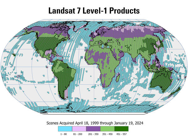
Landsat Level-2 and Level-3 Science Products
Created using Landsat 4-5 TM, Landsat 7 ETM+, and Landsat 8-9 OLI/TIRS data
Landsat U.S. Analysis Ready Data (ARD)
Landsat and the EROS Center
Data archive and distribution center celebrates 50 years in 2023
Landsat Missions
Since 1972, Landsat satellites have continuously acquired images of the Earth’s land surface, providing uninterrupted data to help land managers and policymakers make informed decisions about natural resources and the environment. Data acquired by Landsat satellites are distributed from the USGS Earth Resources Observation and Science (EROS) Center in Sioux Falls, South Dakota.
Landsat Collections

Landsat Collections are tiered management structures that ensure all Landsat Level-1 products are produced to create a consistent archive of known data quality
Science Products and U.S. Analysis Ready Data

Landsat Level-2 and Level-3 Science Products, along with U.S. Analysis Ready Data (ARD), contain higher-level data to allow scientists to better document changes to Earth's terrestrial environment.
Project Information

There is a wealth of technical information and statistics about the Landsat Project, Landsat data, and Landsat science products. Statistics about Landsat data availability, distribution and usage are updated quarterly.
News about Landsat
Find the latest news about Landsat missions, data products, data access, and related topics.
- Read all Landsat Mission Headlines.
- Subscribe to the Latest in Landsat Newsletter.
- Subscribe to Landsat Headlines RSS Feeds.
Landsat Products and Data Access
Landsat data products are continually being matured into the highest quality possible. These products allow scientists to provide improved and more useful results for land change and use analysis. Landsat data products held in the USGS archives can be searched and downloaded at no charge from a variety of data portals.

Useful Tools & Viewers
Various files, tools, converters, and information to better understand Landsat acquisition and how to search for Landsat data and products.
International Collaboration
Landsat has always been an important component of U.S. foreign policy, science, and technology policy. A longstanding network of International Cooperators operate numerous International Ground Stations allowing direct reception and downlink from Landsat satellites. In 2010, International Cooperators started the effort to consolidate Landsat data acquired at worldwide ground station to the USGS archive.
- Learn about the Landsat International Ground Station (IGS) Network.
- Learn about Landsat Global Archive (LGAC) efforts.
- Become an International Cooperator (IC).
Education and Outreach Resources
Landsat education and outreach resources can be used by students, teachers and the general public to further understand the fundamentals of remote sensing, Landsat technology, and how practical applications of Landsat data are helping specialists manage Earth's natural resources for a growing world population.
- View Frequently asked Questions (FAQs).
- Open Landsat Fact Sheets.
- Listen to Eyes on Earth episodes about Landsat.
- Explore Landsat Interactive Storymaps.
Join us on Social!