
Sample graphic of airborne lidar data acquisition. Target area is illuminated by pulsed laser light in the aircraft, Differences in laser return times and wavelengths are then used to make digital 3D representations of the selected ground sections.
Images
Core Science Systems images.
Filter Total Items: 667

3DEP, lidar acquisition
Sample graphic of airborne lidar data acquisition. Target area is illuminated by pulsed laser light in the aircraft, Differences in laser return times and wavelengths are then used to make digital 3D representations of the selected ground sections.

3DEP, lidar point cloud, Denver
A 3D Elevation Program lidar point cloud showing simulated flooding (in blue) of an area in Denver, Colorado
A 3D Elevation Program lidar point cloud showing simulated flooding (in blue) of an area in Denver, Colorado

Oso landslide, 3DEP
Aerial photo of the Oso, Washington landslide in 2014. The red arrows show the direction of material flow. The inset lidar image was derived from 3DEP data collected by the Washington Department of Transportation.
Aerial photo of the Oso, Washington landslide in 2014. The red arrows show the direction of material flow. The inset lidar image was derived from 3DEP data collected by the Washington Department of Transportation.

USGS scientists collecting surface water samples from Pine Creek
USGS scientists collecting surface water samples from Pine CreekUSGS scientists collecting surface water samples from Pine Creek
USGS scientists collecting surface water samples from Pine Creek
USGS scientists collecting surface water samples from Pine CreekUSGS scientists collecting surface water samples from Pine Creek
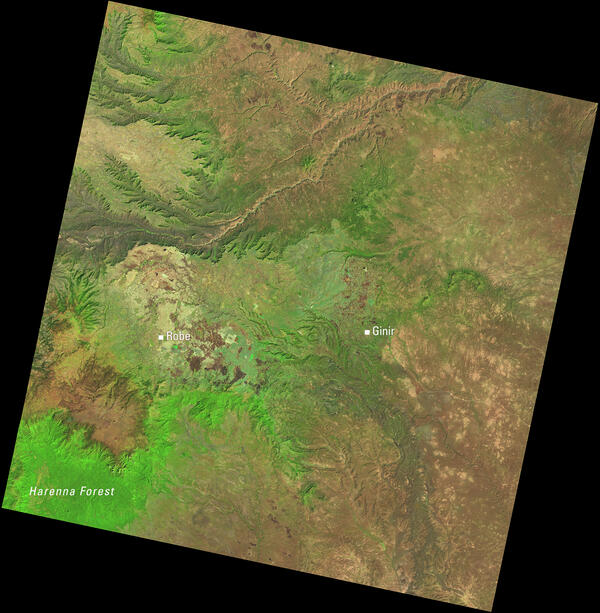
Landsat View of Ethiopia’s Highlands and the Harenna Forest
Landsat View of Ethiopia’s Highlands and the Harenna ForestThis Landsat 8 image of central Ethiopia, acquired January 1, 2014, uses the shortwave infrared, near infrared, and red spectral bands (bands 6,5,4) to emphasize vegetation and land cover. In this combination, healthy vegetation appears bright green.

3DEP, El Paso
3D elevation data for El Paso, Texas, in the form of a lidar point cloud. These data along with other products provide valuable productivity, safety, and cost-saving benefits to instrastructure improvement projects. I(mage provided by Jason Stoker - USGS).
3D elevation data for El Paso, Texas, in the form of a lidar point cloud. These data along with other products provide valuable productivity, safety, and cost-saving benefits to instrastructure improvement projects. I(mage provided by Jason Stoker - USGS).

Nevada Landsat State Mosaic
Nevada was the fastest growing state between 1990 and 2000, with a population growth rate of 66.3 percent. No other state topped 40 percent.
Capital Carson City
Image Source Landsat 8
Population 3,104,614
Number of Pixels 318,192,547
Nevada was the fastest growing state between 1990 and 2000, with a population growth rate of 66.3 percent. No other state topped 40 percent.
Capital Carson City
Image Source Landsat 8
Population 3,104,614
Number of Pixels 318,192,547
ASTER image of the Rio Grande River Valley
ASTER Surface Reflectance (AST_07) data can be used to view complex landscapes like the Rio Grande River Valley in southern New Mexico. This Terra ASTER surface reflectance natural color composite shows differences in reflectance over forested hills, irrigated agriculture, and arid regions.
ASTER Surface Reflectance (AST_07) data can be used to view complex landscapes like the Rio Grande River Valley in southern New Mexico. This Terra ASTER surface reflectance natural color composite shows differences in reflectance over forested hills, irrigated agriculture, and arid regions.

Erosion along Alaska’s Arctic coastline near the village of Kaktovik
Erosion along Alaska’s Arctic coastline near the village of KaktovikNeal Pastick – lead author of the study – investigating erosion along Alaska’s Arctic coastline near the village of Kaktovik. Permafrost-dominated coasts of Alaska have drastically changed as the result of coastal transgression and storm-surge flooding which can result in the loss of cultural sites and damage to infrastructure. Photo by M.

Example of the Landsat 8 Collection 2 products
Left: Landsat 8 Collection 2 level-1 top of atmosphere reflectance image, center: Landsat 8 Collection 2 level-2 atmospherically corrected surface reflectance image, and right: Landsat 8 Collection 2 level-2 surface temperature image for an area over the Sapta Koshi River in Bairawa, Nepal (path 140 row 41) acquired on
Left: Landsat 8 Collection 2 level-1 top of atmosphere reflectance image, center: Landsat 8 Collection 2 level-2 atmospherically corrected surface reflectance image, and right: Landsat 8 Collection 2 level-2 surface temperature image for an area over the Sapta Koshi River in Bairawa, Nepal (path 140 row 41) acquired on

Example of Landsat 8 OLI/TIRS Collection 2 level-2 science products
Example of Landsat 8 OLI/TIRS Collection 2 level-2 science productsExample of the Landsat 8 OLI/TIRS Collection 2 level-2 science products. Left: Landsat 8 level-2 surface reflectance image. Right: Landsat 8 level-2 surface temperature image. The data was acquired on May 3, 2013 (path 140 row 41).

Boulder, Colorado - Landsat 8
Landsat 8’s first image captured the area where the Great Plains and Rocky Mountains meet in Colorado in March 2013. The natural-color image shows the coniferous forest of the mountains coming down to the dormant plains. Boulder, Colorado, sits in the middle of the image.
Landsat 8’s first image captured the area where the Great Plains and Rocky Mountains meet in Colorado in March 2013. The natural-color image shows the coniferous forest of the mountains coming down to the dormant plains. Boulder, Colorado, sits in the middle of the image.

Collecting data at Ellis Island after Hurricane Sandy
Collecting data at Ellis Island after Hurricane SandyPhoto Contest Winner | Feb. 2020 | Where We Work
Collecting data at Ellis Island after Hurricane Sandy
Collecting data at Ellis Island after Hurricane Sandy
Collecting data at Ellis Island after Hurricane SandyPhoto Contest Winner | Feb. 2020 | Where We Work
Collecting data at Ellis Island after Hurricane Sandy

Collecting data at Ellis Island after Hurricane Sandy
Collecting data at Ellis Island after Hurricane SandyPhoto Contest Winner | Feb. 2020 | Honorable Mention 2
Collecting data at Ellis Island after Hurricane Sandy
Collecting data at Ellis Island after Hurricane Sandy
Collecting data at Ellis Island after Hurricane SandyPhoto Contest Winner | Feb. 2020 | Honorable Mention 2
Collecting data at Ellis Island after Hurricane Sandy

Box turtle
Photo Contest Winner | Feb. 2020 | Honorable Mention 1
Box turtle
Photo Contest Winner | Feb. 2020 | Honorable Mention 1
Box turtle

Kevin Gallagher speaks at Alaska Mapping Roundtable
Kevin Gallagher speaks at Alaska Mapping RoundtableKevin T. Gallagher, USGS Associate Director, Core Science Systems, address members
of the Alaska Mapping Roundtable on the issues and status of completing the mapping of Alaska.
Kevin Gallagher speaks at Alaska Mapping Roundtable
Kevin Gallagher speaks at Alaska Mapping RoundtableKevin T. Gallagher, USGS Associate Director, Core Science Systems, address members
of the Alaska Mapping Roundtable on the issues and status of completing the mapping of Alaska.

MRO-HIRISE-South-Pole-Ice-ESP_023464_0945.jpg
The image is from the Martian southern polar region. CO2 ice shown here is about 10 feet thick, and the semi-circular depressions are about 200 ft across.
The image is from the Martian southern polar region. CO2 ice shown here is about 10 feet thick, and the semi-circular depressions are about 200 ft across.
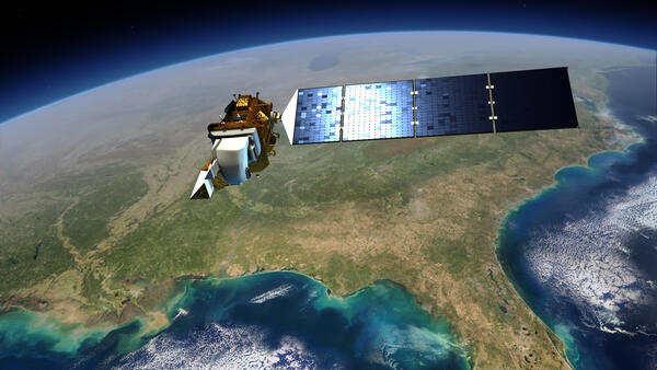
Image of Landsat 8 over the US
This illustration shows the Landsat 8 satellite in space over the southeastern United States.
This illustration shows the Landsat 8 satellite in space over the southeastern United States.

Tuscaloosa-Birmingham Tornado Scar, April 2011
The roughly west-east trail of destruction from the April 27, 2011, Tuscaloosa-Birmingham tornado is clearly visible in these Landsat images. This was one of 358 recorded tornadoes during the April 25-28, 2011, tornado outbreak, the most severe in U.S. history.
The roughly west-east trail of destruction from the April 27, 2011, Tuscaloosa-Birmingham tornado is clearly visible in these Landsat images. This was one of 358 recorded tornadoes during the April 25-28, 2011, tornado outbreak, the most severe in U.S. history.

Example of the Landsat Collection 2 Fractional Snow Covered Snow Science Product
Example of the Landsat Collection 2 Fractional Snow Covered Snow Science ProductExample of the Landsat Collection 2 Fractional Snow Covered Area (fSCA) Science Product showing an area in the Dixie National Forest in Utah on February 28, 2021 for tile h007V010. Left: Landsat Collection 2 U.S. Analysis Ready Data Surface Reflectance image, Middle: fSCA, and Right: Canopy Adjusted fSCA.

Landsat 5 image showing the Seattle, Washington area
Landsat 5 image showing the Seattle, Washington areaExample of the Landsat 4-5 TM Collection 2 level-1 product. This Landsat 5 image was acquired on October 6, 2010 near Seattle, Washington and is shown as a natural color composite using the red, green, and blue bands (bands 3,2,1).