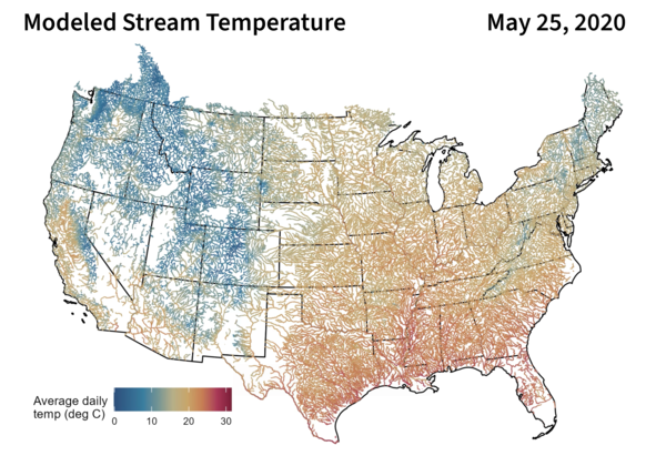
U.S. flag

An official website of the United States government

Multimedia

This multimedia gallery represents a collection of high-quality images, videos, webcams, posters, presentations, and documents produced by the Water Resources Mission Area.

Images

Image of man with water sample near a mobile lab in a open forest
Groundwater quality measurements at a mobile lab

Oklahoma-Texas Water Science Center Hydrologic Technician Dwight Sparks purges a monitoring well in Austin Texas to ensure stable field parameters before collecting a groundwater sample.

Oklahoma-Texas Water Science Center Hydrologic Technician Dwight Sparks purges a monitoring well in Austin Texas to ensure stable field parameters before collecting a groundwater sample.

USGS van and mobile groundwater sampling site
Mobile groundwater quality lab and USGS van

Oklahoma-Texas Water Science Center Hydrologic Technician Sam Matschek processes a groundwater sample at a monitoring well in Austin Texas. This groundwater sampling effort was to quantify geogenic contaminations in groundwater aquifers.

Oklahoma-Texas Water Science Center Hydrologic Technician Sam Matschek processes a groundwater sample at a monitoring well in Austin Texas. This groundwater sampling effort was to quantify geogenic contaminations in groundwater aquifers.

Image of man in hiviz gear taking measurements
Groundwater quality measurements in MN

USGS scientist takes measurements of groundwater quality from a monitoring well near Zimmerman, Minnesota.

Screenshot of the Water Data for the Nation homepage highlighting 6 core ways to interact with USGS water data
Water Data for the Nation (WDFN) homepage

Screenshot of the Water Data for the Nation (WDFN) homepage. WDFN is the home for USGS's modernization of public delivery of water data. USGS water data can be accessed in many ways:

Screenshot of the Water Data for the Nation (WDFN) homepage. WDFN is the home for USGS's modernization of public delivery of water data. USGS water data can be accessed in many ways:

Videos

Faint orange creek running through green brush. Faint orange creek running through green brush.
Rusting Rivers B-Roll: Anatok Creek, Alaska

This is B-roll video of Anatok Creek, Kobuk Valley National Park, Alaska from August 19, 2025.

WDFN Webinar title slide WDFN Webinar title slide
Water Data for the Nation - New Features and NWISWeb Decommissioning Webinar

This recording of a public webinar highlights new features of Water Data for the Nation (WDFN) and the NWISWeb decommissioning effort.

National water availability assessment data companion webinar opening slide National water availability assessment data companion webinar opening slide
New Modeled Water Data: Data Companion Release January 2026

This recorded webinar demonstrates how to access and use new modeled water data delivered through the National Water Availability Assessment Data Companion (NWDC). The NWDC is a centralized website providing USGS model-derived water availability, supply, and use information that underlies the National Water Availability Assessment Report.

This recorded webinar demonstrates how to access and use new modeled water data delivered through the National Water Availability Assessment Data Companion (NWDC). The NWDC is a centralized website providing USGS model-derived water availability, supply, and use information that underlies the National Water Availability Assessment Report.

U.S. River Conditions for Water Year 2025 U.S. River Conditions for Water Year 2025
U.S. River Conditions, Water Year 2025

This is an animation showing the changing conditions relative to the historic record of USGS streamgages from October 1, 2024 - September 30, 2025. The river conditions shown range from the driest condition seen at a gage (red open circles) to the wettest (blue closed circles). A purple outer ring around a gage indicates it is flooding.   

This is an animation showing the changing conditions relative to the historic record of USGS streamgages from October 1, 2024 - September 30, 2025. The river conditions shown range from the driest condition seen at a gage (red open circles) to the wettest (blue closed circles). A purple outer ring around a gage indicates it is flooding.   

Map of U.S. River Conditions, July to September 2025 Map of U.S. River Conditions, July to September 2025
U.S. River Conditions, July to September 2025

This is an animation showing the changing conditions relative to the historic record of USGS streamgages from July 1, 2025, to September 30, 2025. The river conditions shown range from the driest condition seen at a gage (red open circles) to the wettest (blue closed circles). A purple outer ring around a gage indicates it is flooding.   

This is an animation showing the changing conditions relative to the historic record of USGS streamgages from July 1, 2025, to September 30, 2025. The river conditions shown range from the driest condition seen at a gage (red open circles) to the wettest (blue closed circles). A purple outer ring around a gage indicates it is flooding.   

Audio

Color photo of Roy Sando with graphic for USGS EROS podcast Eyes on Earth
Eyes on Earth - U.S.-Canada Water Use
Eyes on Earth Episode 43 - U.S.-Canada Water Use
Color photo of Roy Sando with graphic for USGS EROS podcast Eyes on Earth
Eyes on Earth - U.S.-Canada Water Use
Eyes on Earth Episode 43 - U.S.-Canada Water Use

The St. Mary and Milk Rivers cross the U.S. and Canadian border and supply water to both countries. Managing that resource in the interest of both nations is a matter of international collaboration and cooperation, and Landsat data is helping offer objective information on water use.

The St. Mary and Milk Rivers cross the U.S. and Canadian border and supply water to both countries. Managing that resource in the interest of both nations is a matter of international collaboration and cooperation, and Landsat data is helping offer objective information on water use.

USGS
USGS Visual Identity - Black (TM)
Responding to Hurricanes, Floods and Droughts in North Carolina
USGS
USGS Visual Identity - Black (TM)
Responding to Hurricanes, Floods and Droughts in North Carolina

North Carolina, like many years before, is responding to flooding in the East and drought in the West. Holly Weyers, USGS North Carolina Water Science Center Director, discusses these extreme events.

North Carolina, like many years before, is responding to flooding in the East and drought in the West. Holly Weyers, USGS North Carolina Water Science Center Director, discusses these extreme events.

USGS CoreCast
USGS CoreCast Series
Groundwater Awareness Week is March 6-12
USGS CoreCast
USGS CoreCast Series
Groundwater Awareness Week is March 6-12

Groundwater is not a single vast pool of underground water; rather, it is contained within a variety of aquifer systems. Each of these aquifers has its own set of questions and challenges.

Groundwater is not a single vast pool of underground water; rather, it is contained within a variety of aquifer systems. Each of these aquifers has its own set of questions and challenges.

USGS
USGS Visual Identity - Black (TM)
USGS Hydrologic Data Collection Program in North Carolina
USGS
USGS Visual Identity - Black (TM)
USGS Hydrologic Data Collection Program in North Carolina

USGS North Carolina Data Chief, Jeanne Robbins, provides an overview on hydrologic data collection techniques for North Carolina.

USGS
USGS Visual Identity - Black (TM)
Marking the Milestone, The Triangle Area Water Supply Monitoring Proj
USGS
USGS Visual Identity - Black (TM)
Hurricane Floyd, and the Floods of 1999
USGS
USGS Visual Identity - Black (TM)
Hurricane Floyd, and the Floods of 1999

USGS North Carolina Water Science Center Director Jerad Bales discusses Hurricane Floyd and flood impacts on North Carolina in 1999.

USGS North Carolina Water Science Center Director Jerad Bales discusses Hurricane Floyd and flood impacts on North Carolina in 1999.

Webcams

Current view of the HIF construction project in Tuscaloosa, Alabama.
HIF Construction in Tuscaloosa, Alabama

The current view of construction progress at the new HIF facility in Tuscaloosa, Alabama.

Looking at river from side of the bridge.
Streamgage 01437500 Neversink River at Godeffroy, NY
Webcam image of the Delaware River looking at New Hope, PA
Streamgage 01462000 Delaware River at Lambertville, NJ
Most recent image of the Colorado River near Cameo, CO
Colorado River near Cameo, CO (09095500)

Webcam at USGS Streamgage 09095500 Colorado River near Cameo, CO.

Visit Water Data For the Nation to get current data for this site.

Most recent image of the Colorado River above Glenwood Springs
Colorado River above Glenwood Springs, CO (09071750)

Webcam at USGS Streamgage 09071750 Colorado River above Glenwood Springs, CO.

Visit Water Data For the Nation to get current data for this site.

Was this page helpful?