Installing new radar sensor and staff plate, Big Sandy River
Installing new radar sensor and staff plate, Big Sandy RiverInstalling new radar sensor and staff plate, Big Sandy River

Official websites use .gov
A .gov website belongs to an official government organization in the United States.
Secure .gov websites use HTTPS
A lock () or https:// means you’ve safely connected to the .gov website. Share sensitive information only on official, secure websites.
Explore our planet through photography and imagery, including climate change and water all the way back to the 1800s when the USGS was surveying the country by horse and buggy.

Installing new radar sensor and staff plate, Big Sandy River
Installing new radar sensor and staff plate, Big Sandy River

Tropical Storm Nate's predicted effect on Northern Gulf sandy shorelines, based on landfall as a Category 1 hurricane, is shown at three intensities. Outer band: Dune erosion. Middle band: Dune overwash. Inner band: Dune inundation, with potential flooding behind the dune. Credit: USGS Coastal Change Hazard Portal.
Tropical Storm Nate's predicted effect on Northern Gulf sandy shorelines, based on landfall as a Category 1 hurricane, is shown at three intensities. Outer band: Dune erosion. Middle band: Dune overwash. Inner band: Dune inundation, with potential flooding behind the dune. Credit: USGS Coastal Change Hazard Portal.

This view of Halema‘uma‘u as it appeared in the 1917 relief model by George Carroll Curtis shows fine details around the crater, including the first road for automobiles, which ended near the crater rim. The light-colored circular feature around Halema‘uma‘u is a nearly continuous escarpment along which subsidence occurred. Photo by Burr A. Church.
This view of Halema‘uma‘u as it appeared in the 1917 relief model by George Carroll Curtis shows fine details around the crater, including the first road for automobiles, which ended near the crater rim. The light-colored circular feature around Halema‘uma‘u is a nearly continuous escarpment along which subsidence occurred. Photo by Burr A. Church.

The 1917 Curtis relief model of Kīlauea Volcano's summit shows many well-known geologic features, including the summit caldera (large depression), Halema‘uma‘u (crater within the caldera), Kīlauea Iki (crater at far right), and elaborate drainage patterns (foreground). Photo by Burr A. Church.
The 1917 Curtis relief model of Kīlauea Volcano's summit shows many well-known geologic features, including the summit caldera (large depression), Halema‘uma‘u (crater within the caldera), Kīlauea Iki (crater at far right), and elaborate drainage patterns (foreground). Photo by Burr A. Church.

Kanakee River at Davis, IN - downstrean of bridge
Kanakee River at Davis, IN - downstrean of bridge

Kankakee River at Davis, IN - downstream from bridge
Kankakee River at Davis, IN - downstream from bridge

Yellow Creek at Knox, IN - downstream measurement

Yellow River at Knox, IN - control under bridge

Yellow River at Knox, IN - downstream of bridge

Grand River near Painesville, OH - bridge view

This old male tortoise was experimentally translocated to a site that had been previously burned in wildfire to understand how tortoise grow and survive in habitat that is disturbed by fires.
This old male tortoise was experimentally translocated to a site that had been previously burned in wildfire to understand how tortoise grow and survive in habitat that is disturbed by fires.

Monazite grains with rare earth elements lanthenum, cerium and neodinium are associated with zirconium, pyrite and potassium feldspar. Mineral identification performed by a combination of scanning of electron microscopy (SEM) and electron microprobe.
Monazite grains with rare earth elements lanthenum, cerium and neodinium are associated with zirconium, pyrite and potassium feldspar. Mineral identification performed by a combination of scanning of electron microscopy (SEM) and electron microprobe.

The iconic Sonoran Desert is home to many species of cactus, vascular plants, and wildlife, including the giant saguaro, cholla, and prickley pear cacti seen here. Plants and animals have adapted to living in such a harsh dry environment.
The iconic Sonoran Desert is home to many species of cactus, vascular plants, and wildlife, including the giant saguaro, cholla, and prickley pear cacti seen here. Plants and animals have adapted to living in such a harsh dry environment.

Sunset at Big Meadows in Shenandoah National Park, Virginia with tree silhouettes.
Sunset at Big Meadows in Shenandoah National Park, Virginia with tree silhouettes.

Drilling and core sampling on the Shinnecock Tribal Lands, Long Island, NY
Drilling and core sampling on the Shinnecock Tribal Lands, Long Island, NY
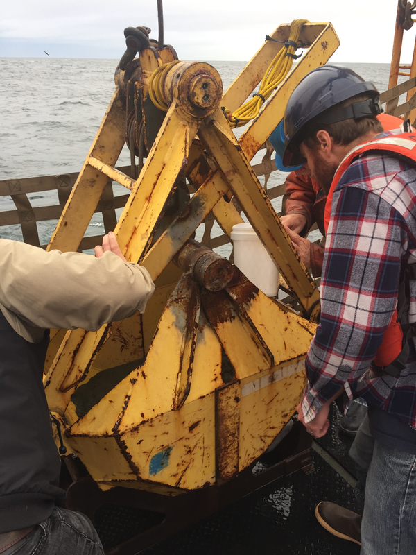
USGS research geophysicist Danny Brothers (right) and colleagues examine the surface of a sediment grab sample just pulled onto the deck of the Canadian Coast Guard Ship John P. Tully. The sample was collected from the top of a mud volcano north of the border between southeast Alaska and British Columbia.
USGS research geophysicist Danny Brothers (right) and colleagues examine the surface of a sediment grab sample just pulled onto the deck of the Canadian Coast Guard Ship John P. Tully. The sample was collected from the top of a mud volcano north of the border between southeast Alaska and British Columbia.

Aerial view of Spirit Lake (center) looking north from above the crater of Mount St. Helens. The lake's outlet to the west (left) was blocked by the 1980 landslide, which required a new engineered outlet to maintain the lake at a safe level. A tunnel was drilled through a bedrock ridge on west side of lake in 1984-1985. Glacier covered Mount Rainier in distance.
Aerial view of Spirit Lake (center) looking north from above the crater of Mount St. Helens. The lake's outlet to the west (left) was blocked by the 1980 landslide, which required a new engineered outlet to maintain the lake at a safe level. A tunnel was drilled through a bedrock ridge on west side of lake in 1984-1985. Glacier covered Mount Rainier in distance.

Pine Island Glacier in Antarctica has snapped off its share of icebergs in recent years. The frequency of noteworthy breaks is evidence that the ice shelf is becoming increasingly fragile. The latest iceberg cracked off the end of the Pine Island Glacier ice shelf around September 23, 2017.
Pine Island Glacier in Antarctica has snapped off its share of icebergs in recent years. The frequency of noteworthy breaks is evidence that the ice shelf is becoming increasingly fragile. The latest iceberg cracked off the end of the Pine Island Glacier ice shelf around September 23, 2017.

Scientists from the U.S. Geological Survey and Idaho Power Company collected water, sediment, and biological samples from Brownlee Reservoir as part of an ongoing, cooperative study of mercury cycling in the Hells Canyon complex of reservoirs along the Snake River bordering Idaho and Oregon.
Scientists from the U.S. Geological Survey and Idaho Power Company collected water, sediment, and biological samples from Brownlee Reservoir as part of an ongoing, cooperative study of mercury cycling in the Hells Canyon complex of reservoirs along the Snake River bordering Idaho and Oregon.

USGS WERC scientist Emily (Emma) Kelsey at False Klamath Rock doing seabird monitoring research.
USGS WERC scientist Emily (Emma) Kelsey at False Klamath Rock doing seabird monitoring research.

USGS WERC scientist Jonathan Felis on False Klamath Rock doing seabird monitoring research.
USGS WERC scientist Jonathan Felis on False Klamath Rock doing seabird monitoring research.