
This table shows the Landsat 8-9 Collection 2 Quality Assessment pixel (QA_PIXEL) Value Interpretations. QA_PIXEL Band file contains quality statistics gathered from the image data and cloud mask information for the scene.
Images
The National Land Imaging Program supports a variety of geospatial data programs and projects, including the USGS Landsat Program. Browse the images below to see some of the imagery produced using NLI-supported data sources.
Filter Total Items: 435
Collection 2 Landsat 8-9 Pixel Quality Assessment (QA_PIXEL) Value Interpretations
This table shows the Landsat 8-9 Collection 2 Quality Assessment pixel (QA_PIXEL) Value Interpretations. QA_PIXEL Band file contains quality statistics gathered from the image data and cloud mask information for the scene.

Landsat Missions Timeline
In a September 21, 1966 press release, Secretary of the Interior Stewart Udall announced that the DOI was launching "Project EROS (Earth Resources Observation Satellites)." Udall's vision was to observe the Earth for the benefit of all.
In a September 21, 1966 press release, Secretary of the Interior Stewart Udall announced that the DOI was launching "Project EROS (Earth Resources Observation Satellites)." Udall's vision was to observe the Earth for the benefit of all.

Landsat 8 Mosaic of Okavango Delta
The Okavango Delta in Botswana, one of the world’s great inland waterways, is an UNESCO World Heritage Site as well as one of the Seven Natural Wonders of Africa.
The Okavango Delta in Botswana, one of the world’s great inland waterways, is an UNESCO World Heritage Site as well as one of the Seven Natural Wonders of Africa.

Pecora Award 2024 Call for Nominations
Pecora award 2024 flyer announcing call for nominations, due May 15, 2024. This image details the procedure for nominations, eligibility, and privacy statement. Visit this USGS page for eligibility requirements and the nomination process.
Pecora award 2024 flyer announcing call for nominations, due May 15, 2024. This image details the procedure for nominations, eligibility, and privacy statement. Visit this USGS page for eligibility requirements and the nomination process.

The USGS Landsat International Cooperator Network met for the Landsat Technical Working Group (LTWG) #32 meeting
linkThe USGS Landsat International Cooperator Network met for the Landsat Technical Working Group (LTWG) #32 meeting in Orlando, Florida USA during the first week of February.
The USGS Landsat International Cooperator Network met for the Landsat Technical Working Group (LTWG) #32 meeting
linkThe USGS Landsat International Cooperator Network met for the Landsat Technical Working Group (LTWG) #32 meeting in Orlando, Florida USA during the first week of February.

Current Landsat Ground Network (LGN) Stations
Here is an illustration of the 14 receiving stations that make up the Landsat 8 and Landsat 9 USGS Ground Networks. Learn more about the International Ground Station (IGS) Network here.
Here is an illustration of the 14 receiving stations that make up the Landsat 8 and Landsat 9 USGS Ground Networks. Learn more about the International Ground Station (IGS) Network here.

The YellowScan Navigator Bathymetric Lidar Scanner awaits preflight checks near the South Platte River, Denver, CO.
linkThe YellowScan Navigator Bathymetric Lidar Scanner awaits preflight checks near the South Platte River, Denver, CO.
The YellowScan Navigator Bathymetric Lidar Scanner awaits preflight checks near the South Platte River, Denver, CO.
linkThe YellowScan Navigator Bathymetric Lidar Scanner awaits preflight checks near the South Platte River, Denver, CO.

Landsat 7 Image of the Southern Fringe of the Rub' al-Khali Sand Desert in Oman
Landsat 7 Image of the Southern Fringe of the Rub' al-Khali Sand Desert near Al-Hashman, Oman. This gap-filled image was captured on January 18, 2024 and is shown using the shortwave infrared, near infrared and red bands (Bands 5|4|3).
To learn more about the Landsat Program visit www.usgs.gov/landsat

Landsat 8 Image of Van Diemen Gulf
This image of the Van Diemen Gulf was acquired by the Operational Land Imager (OLI) onboard the Landsat 8 satellite on November 18, 2023.
This image of the Van Diemen Gulf was acquired by the Operational Land Imager (OLI) onboard the Landsat 8 satellite on November 18, 2023.
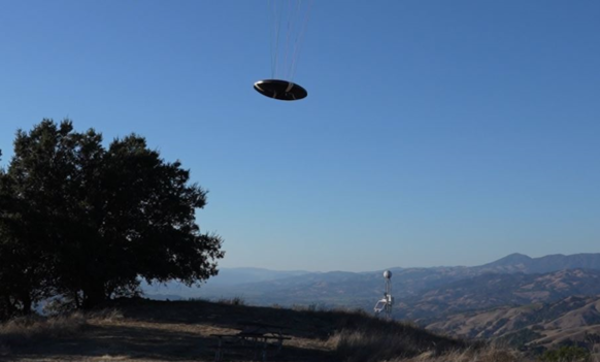
Flying Saucer Shark Deployed over the skies of California
USGS National Innovation Center UAS Research Center Saucer Shark Project, during flight tests, aeroshell. Saucer Shark on landing approach after completed mission. Just above the landing pad.
USGS National Innovation Center UAS Research Center Saucer Shark Project, during flight tests, aeroshell. Saucer Shark on landing approach after completed mission. Just above the landing pad.

Saucer Shark Drop Release during testing campaign
USGS National Innovation Center UAS Research Center Saucer Shark Project, during flight tests, drop release attached to USGS UAV. Aircraft sits on landing pad in-between test flights.
USGS National Innovation Center UAS Research Center Saucer Shark Project, during flight tests, drop release attached to USGS UAV. Aircraft sits on landing pad in-between test flights.

Saucer Shark Deployed Below UAV
USGS National Innovation Center UAS Research Center (UASRC) Saucer Shark Project, during flight tests, fully assembled. Sub assemblies from top down: Drop Release, Sling and Sling Brace, Payload Aeroshell and Payload.
USGS National Innovation Center UAS Research Center (UASRC) Saucer Shark Project, during flight tests, fully assembled. Sub assemblies from top down: Drop Release, Sling and Sling Brace, Payload Aeroshell and Payload.

The Landsat Flight Operations Team Monitoring Landsat 8 Maneuver
This image shows the Landsat Flight Operations Team monitoring the maneuver in real time.
This image shows the Landsat Flight Operations Team monitoring the maneuver in real time.

Landsat 9 image of Snæfellsjökull and Snæfellsnes Peninsula in west Iceland
Landsat 9 captured this image of Snæfellsjökull, a glacier-capped volcano that sits at the tip of the Snæfellsnes Peninsula in west Iceland on August 9, 2023.
WRS-2 Path 222 Row 214
Bands 6,5,4
To learn more about Landsat, visit https://www.usgs.gov/landsat-missions.
Landsat 9 captured this image of Snæfellsjökull, a glacier-capped volcano that sits at the tip of the Snæfellsnes Peninsula in west Iceland on August 9, 2023.
WRS-2 Path 222 Row 214
Bands 6,5,4
To learn more about Landsat, visit https://www.usgs.gov/landsat-missions.

Landsat 8 Image of the Mississippi River Delta
Landsat 8's Operational Land Imager (OLI) captured this image of the Mississippi River Delta on September 18, 2023.
Landsat 8
Path 21 Row
September 18, 2023
Bands 6,5,4
Landsat 8's Operational Land Imager (OLI) captured this image of the Mississippi River Delta on September 18, 2023.
Landsat 8
Path 21 Row
September 18, 2023
Bands 6,5,4

EROS 50th Anniversary Reception
The USGS Earth Resources Observation and Science (EROS) Center reception area fills with people for a 50th anniversary event August 19, 2023.
The USGS Earth Resources Observation and Science (EROS) Center reception area fills with people for a 50th anniversary event August 19, 2023.
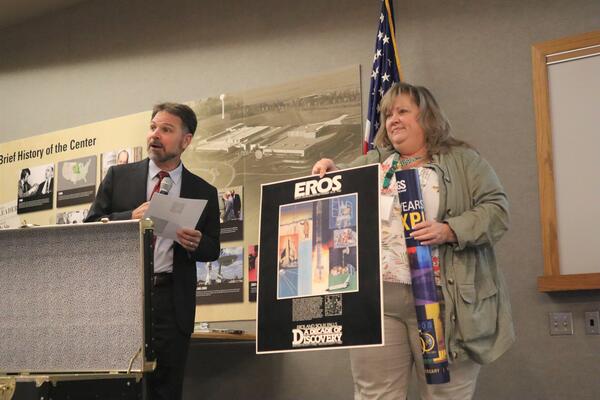
USGS EROS Center Director Pete Doucette and Branch Chief for New Missions Kristi Kline
While USGS Earth Resources Observation and Science (EROS) Center Director Pete Doucette tells the audience a little about the 10th anniversary festivities at EROS during the August 18, 2023, rededication ceremony, EROS Branch Chief for New Missions Kristi Kline holds up a 10th anniversary poster from the time capsule and prepares to add a 50
While USGS Earth Resources Observation and Science (EROS) Center Director Pete Doucette tells the audience a little about the 10th anniversary festivities at EROS during the August 18, 2023, rededication ceremony, EROS Branch Chief for New Missions Kristi Kline holds up a 10th anniversary poster from the time capsule and prepares to add a 50

Sioux Falls, South Dakota, Puzzle
Large floor puzzles of Sioux Falls and Denver help entertain guests during the 50th anniversary event August 19, 2023.
Large floor puzzles of Sioux Falls and Denver help entertain guests during the 50th anniversary event August 19, 2023.

USGS Director David Applegate and USGS EROS Center Director Pete Doucette plant a tree
On August 19, 2023, USGS Director David Applegate and USGS Earth Resources Observation and Science (EROS) Center Director Pete Doucette use golden shovels that have been used at other EROS dedication events to help dedicate a red oak tree, a long-living species, that will be planted at EROS as a symbolic gesture to its future beyond 50 years.
On August 19, 2023, USGS Director David Applegate and USGS Earth Resources Observation and Science (EROS) Center Director Pete Doucette use golden shovels that have been used at other EROS dedication events to help dedicate a red oak tree, a long-living species, that will be planted at EROS as a symbolic gesture to its future beyond 50 years.

Landsat View of Honolulu Area
This Landsat 8 image, acquired June 11, 2023, gives a view Hawaii's state capital Honolulu and the surrounding area along the eastern shoreline of O'ahu. Center in this image is the Daniel K.
This Landsat 8 image, acquired June 11, 2023, gives a view Hawaii's state capital Honolulu and the surrounding area along the eastern shoreline of O'ahu. Center in this image is the Daniel K.

EROS By the Numbers (1975)
Infographic highlighting EROS numbers in 1975. Text reads:
By the Numbers: EROS in 1975
Infographic highlighting EROS numbers in 1975. Text reads:
By the Numbers: EROS in 1975