
Surface Water
Surface Water
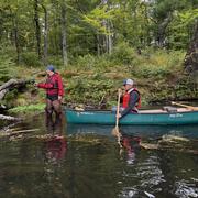
The New England Water Science Center has a long history of monitoring surface-water conditions throughout New England. Continuous and discrete measurements of streamflow and water levels of lakes, reservoirs, and coastal zones provide the foundation for hydrologic assessments, hydraulic and climate-change modeling, and reporting streamflow during floods and droughts.
Filter Total Items: 45
Thermal Imagery to Inform Brook Trout Habitat Suitability and Restoration Potential, Upper Namekagon River, Wisconsin
The U.S. Geological Survey (USGS), in cooperation with the National Park Service (NPS), is using thermal infrared technology to identify cold-water habitat for brook trout and other cold-water species in the upper Namekagon River in Wisconsin. The upper Namekagon River and its tributaries have long served as a stronghold for brook trout and other cold- and cool-water species; however, changing...

December 2023 Flood in Maine
The U.S. Geological Survey (USGS) New England Water Science Center, in cooperation with the Federal Emergency Management Agency (FEMA), is conducting a study to characterize the magnitude and extent of the December 18-21, 2023 Flood in various portions of the State of Maine.

July 2023 Flood in Vermont
From July 9 through July 12, 2023, 3 to 9 inches of rain fell within 48 hours across the state of Vermont, causing catastrophic flooding and millions of dollars in damage. The high amount of rain caused several rivers to peak at record levels, in some cases exceeding records set during Tropical Storm Irene in 2011.

Outlining High-Resolution Urban Drainage Systems for Stormwater Management in the Neponset River Watershed
The natural environment and manmade infrastructure must be considered when characterizing hydrology and water quality in urban watersheds. This requirement is critical in stormwater management, which considers water flowing above ground and below ground through stormwater networks. The U.S. Geological Survey (USGS), with support from the U.S. Environmental Protection Agency (EPA), is expanding its...

Water Cycle Center
The Water Cycle Center is a cooperation between U.S. Geological Survey and academic partners in the Northeast that studies complete water cycles and watersheds, from mountaintops to shorelines, concentrating on freshwater ecosystems. This research advances the understanding of processes that determine water availability and is needed to best address future water resource challenges.

USGS Assessment of Water Resources near Hanscom Air Force Base
The United States Geological Survey (USGS) New England Water Science Center is expanding its scientific investigation to better understand the water resources at, and in the vicinity of, Hanscom Air Force Base (AFB) and the potential impacts from historical base operations and other sources.

Stream Flood Vulnerability Assessment at Acadia National Park
The U.S. Geological Survey (USGS) New England Water Science Center, in cooperation with Acadia National Park, is assessing the vulnerability of the park’s streams, culverts, and bridges to flood damage and erosion using design flows for selected high streamflow recurrence intervals to inform management decisions on infrastructure upgrades.

Water Resources Inventory and Assessment at Katahdin Woods and Waters National Monument
The U.S. Geological Survey (USGS) New England Water Science Center, in cooperation with the National Park Service, is compiling and evaluating all known water resources, and documented infrastructure associated with these resources, within the Katahdin Woods and Waters National Monument and contributing associated watersheds.

A Statewide Hydraulic Modeling Tool for Stream Crossing Projects in Massachusetts
The U.S. Geological Survey (USGS) and the University of Massachusetts at Amherst (UMass Amherst), in cooperation with the Massachusetts Department of Environmental Protection (MassDEP), began a series of studies in 2019 to develop a GIS-based hydraulic modeling tool and to provide preliminary culvert designs for stream-crossing replacement projects in Massachusetts on USGS StreamStats.

Regional Regression Equations for Estimating Selected Low-flow Statistics at Ungaged Stream Sites in Massachusetts
The U.S. Geological Survey, in cooperation with the Massachusetts Department of Recreation and Conservation, Office of Water Resources, began a study in 2019 to update the regional regression equations for estimating selected low-flow statistics at ungaged sites in Massachusetts.

Water Quality Monitoring in the Cambridge Drinking-Water Source Area, Massachusetts
The Cambridge Water Department supplies approximately 13 million gallons per day of drinking water to more than 100,000 customers. Raw water is obtained from a serial system of three primary storage reservoirs—Cambridge Reservoir (also known as the Hobbs Brook Reservoir), Stony Brook Reservoir, and Fresh Pond Reservoir—in parts of Cambridge, Lexington, Lincoln, Waltham, and Weston, Massachusetts...

Evaluation of Lakes and Impoundments Drought Index for the Massachusetts Drought Management Plan
Lake and impoundment levels are used for calculating a drought severity index.