
Groundwater
Groundwater
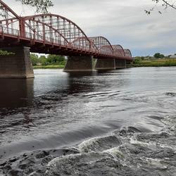
Groundwater provides essential water supplies and aquatic-ecosystem services in New England. The New England Water Science Center collects groundwater data and conducts multidisciplinary studies to improve understanding of the status and trends of groundwater availability, evaluate human stresses on groundwater and coupled groundwater/surface-water systems, and inform water-management decisions.
Filter Total Items: 41
New England Water Conditions Explorer
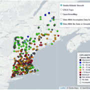
The New England Water Conditions Explorer provides interactive maps showing current surface water and groundwater conditions in the context of historical data.
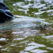
Thermal Imaging to Detect Cold-Water Habitat for Atlantic Salmon and Brook Trout at Katahdin Woods and Waters National Monument
The U.S. Geological Survey (USGS), in cooperation with the National Park Service (NPS), is using airborne thermal infrared remote sensing to characterize cold-water habitat for the federally designated endangered species Atlantic salmon ( Salmo salar) and wild brook trout ( Salvelinus fontinalis) in the East Branch of the Penobscot River system within Katahdin Woods and Waters National Monument...
Statewide Studies of PFAS in Connecticut
The U.S. Geological Survey (USGS) New England Water Science Center, in cooperation with the Connecticut Department of Economic and Community Development (CT DECD) and the Connecticut Department of Energy and Environmental Protection (CT DEEP), is investigating the occurrence of per- and polyfluoroalkyl substances (PFAS) in soils and shallow groundwater across the state of Connecticut. The studies...
Hydrologic Monitoring Branch
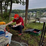
The Hydrologic Monitoring Branch (HMB) provides water data for all six New England states through an expansive network of monitoring locations. The HMB is responsible for a wide range of hydrologic monitoring activities, including collecting and analyzing streamflow, groundwater and coastal water levels, precipitation, and continuous water-quality information, such as water temperature and...

Applied Hydrology Branch
The Applied Hydrology Branch provides hydrologic data, research, and tools to water resource managers, stakeholders and policy makers that inform critical water management decisions throughout New England. This branch is divided into the Hydrology and Hydraulics Section, Water Quality Networks Section, Connecticut Water Quality Monitoring Section, and Massachusetts/Rhode Island Water Quality...
Hydrologic Interpretive Branch
The Hydrologic Interpretive Branch collaborates with stakeholders to design, execute, and publish scientific studies that address issues associated with water resources at local, regional, and national scales. This branch has three sections that focus on watershed and urban hydrology, integrated modeling of hydrologic systems, and the development of new statistical and geospatial tools.
Changes in Nitrogen Contributions from Groundwater to the Niantic River Before and After Sewering
Onsite residential septic systems can be a major nonpoint source of nitrogen contamination. The excess nitrogen entering Connecticut’s Niantic River estuary is associated with high nitrate concentrations in the groundwater of the river’s 28-square-mile watershed, creating unsuitable habitat for the growth and recovery of eelgrass (Zostera marina). In an attempt to improve the river’s water quality...

Estimating Nitrogen Loading from Groundwater and Potential Effects of Sea-Level Rise in Rhode Island's Salt Ponds Region
The U.S. Geological Survey (USGS), in cooperation with the Southeast New England Program of the U.S. Environmental Protection Agency, is estimating the magnitude, spatial distribution, and travel times of nitrogen-loading to ponds and streams in the Salt Ponds region of southern Rhode Island. This information can be used to guide conservation-management efforts aimed at reducing nitrogen inputs to...

Potential Effects of Reductions in Wastewater Return Flow on the Freshwater Flow System in Falmouth, Massachusetts
The U.S. Geological Survey (USGS), in cooperation with the Town of Falmouth, is simulating the potential effects of proposed changes to wastewater return flow on the freshwater system in Falmouth, Massachusetts, using an existing regional groundwater flow model.
Collaborations with EPA on Contaminated Site Hydrology
The U.S. Geological Survey (USGS), in cooperation with the U.S. Environmental Protection Agency (EPA), is developing tools and methods to help assess the fate and transport of anthropogenic and geologically sourced contaminants in the water cycle at waste sites throughout the nation.

Augmented Site Characterization of PFAS Manufacturing and Processing Facilities
The U.S. Geological Survey (USGS) is supporting the U.S. Environmental Protection Agency (EPA) in assessing facilities nationwide that have historically produced per- and polyfluoroalkyl substances (PFAS) or used them in chemical manufacturing processes. In collaboration with EPA subcontractors, USGS is providing subject-matter expertise in PFAS fate and transport in the vadose zone and...

Investigating Connections Between Socioeconomic Data and Populations Susceptible to Private Well-Water Concerns in New Hampshire
The U.S. Geological Survey (USGS) New England Water Science Center, in cooperation with the New Hampshire Department of Environmental Services, is investigating the presence of statistical associations between socioeconomic data (or proxy data) and the susceptibility of private wells to water quality or quantity concerns in New Hampshire.