



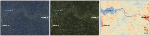
These Landsat 9 Level-1, Level-2 Surface Reflectance, and Level-2 Surface Temperature images show the Columbia River in the northwestern United States.
Multimedia
Explore the USGS Multimedia for access to images, videos, podcasts, and webcams. All items are considered public domain unless otherwise noted.
USGS EROS EarthShots
USGS EROS EarthShots

Earthshots provides examples of how Landsat data helps scientists worldwide understand more about how both people and nature are changing the landscape.
EROS Image Gallery
EROS Image Gallery

Here you can find a vast collection of our favorite images, including state mosaics and Earth as Art.
Images
Landsat Collection 2 Level-1 and Level-2 Images
These Landsat 9 Level-1, Level-2 Surface Reflectance, and Level-2 Surface Temperature images show the Columbia River in the northwestern United States.
Landsat 8 and Landsat 9 Ground Network
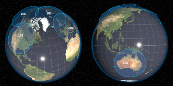
United States ground stations in South Dakota and Alaska, as well as international ground stations in Norway, Germany, and Australia, serve as the primary data capture and Telemetry, Tracking, and Control (TT&C) facilities for the USGS Landsat satellite missions.
United States ground stations in South Dakota and Alaska, as well as international ground stations in Norway, Germany, and Australia, serve as the primary data capture and Telemetry, Tracking, and Control (TT&C) facilities for the USGS Landsat satellite missions.
Landsat Satellite Dish Inside the USGS EROS Radome
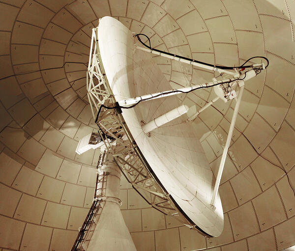
Landsat Satellite Dish Inside the USGS EROS RadomeThe Landsat satellite dish is housed in a protective radome on the USGS EROS grounds. The dish receives data from the Landsat 8 and Landsat 9 satellites each day.
Landsat Satellite Dish Inside the USGS EROS Radome
Landsat Satellite Dish Inside the USGS EROS RadomeThe Landsat satellite dish is housed in a protective radome on the USGS EROS grounds. The dish receives data from the Landsat 8 and Landsat 9 satellites each day.
Landsat View of the Grand Canyon
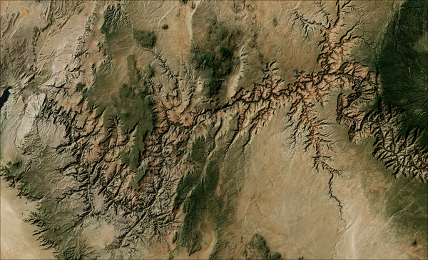
Landsat 8 and 9 imagery combined with National Elevation Dataset topography reveals a detailed mosaic of the Grand Canyon, highlighting its dramatic cliffs, deep tributaries, and rugged plateau terrain.
Landsat 8 and 9 imagery combined with National Elevation Dataset topography reveals a detailed mosaic of the Grand Canyon, highlighting its dramatic cliffs, deep tributaries, and rugged plateau terrain.
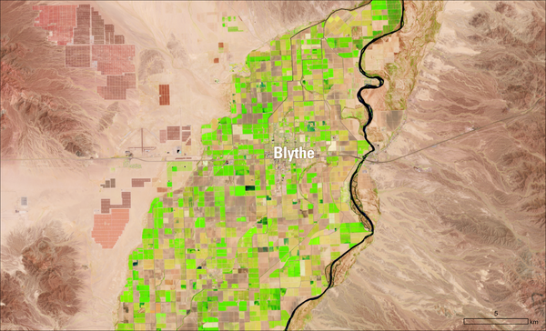
Landsat View of Blythe, California
This Landsat image from July 23, 2026, shows agricultural fields surrounding Blythe, California, along the Colorado River. The shortwave infrared, near-infrared, and red band combination (Bands 6,5,4) highlights actively growing vegetation in bright green.
This Landsat image from July 23, 2026, shows agricultural fields surrounding Blythe, California, along the Colorado River. The shortwave infrared, near-infrared, and red band combination (Bands 6,5,4) highlights actively growing vegetation in bright green.
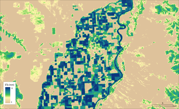
Evapotranspiration Near Blythe, California
This map shows the Landsat Actual Evapotranspiration (ETa) for the Blythe area on July 23, 2026. Darker blues represent higher amounts of water transferred from the land to the atmosphere through evaporation and plant transpiration, primarily in irrigated fields and along the Colorado River.
This map shows the Landsat Actual Evapotranspiration (ETa) for the Blythe area on July 23, 2026. Darker blues represent higher amounts of water transferred from the land to the atmosphere through evaporation and plant transpiration, primarily in irrigated fields and along the Colorado River.
Videos
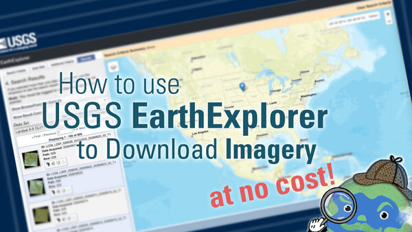
How to Use USGS EarthExplorer to Download Imagery
This video covers EarthExplorer, or EE, which allows users to search for satellite and aerial imagery, preview browse images, export metadata, and download earth science data from the archives of the U.S. Geological Survey (USGS) Earth Resources Observation and Science (EROS) center.
This video covers EarthExplorer, or EE, which allows users to search for satellite and aerial imagery, preview browse images, export metadata, and download earth science data from the archives of the U.S. Geological Survey (USGS) Earth Resources Observation and Science (EROS) center.

Landsat: Products & Services from the USGS - Webinar, September 2023
Landsat: Products & Services from the USGS - Webinar, September 2023The USGS Earth Resources Observation and Science (EROS) Center maintains the largest civilian collection of images of the Earth’s land surface. At EROS we study land change and produce land change data products used by researchers, resource managers, and policymakers across the nation and around the world.
Landsat: Products & Services from the USGS - Webinar, September 2023
Landsat: Products & Services from the USGS - Webinar, September 2023The USGS Earth Resources Observation and Science (EROS) Center maintains the largest civilian collection of images of the Earth’s land surface. At EROS we study land change and produce land change data products used by researchers, resource managers, and policymakers across the nation and around the world.

Landsat Records 50 Years of Growth in Dallas-Fort Worth
Landsat Records 50 Years of Growth in Dallas-Fort WorthLandsat 1 celebrated its 50th anniversary on July 23, 2022!
Landsat 1's first satellite image shared with the world was a view of Dallas-Fort Worth, Texas. Over the course of five decades, Landsat satellites have captured the Dallas-Fort Worth area 2033 times, compiled into individual scenes in the Landsat Archive.
Landsat Records 50 Years of Growth in Dallas-Fort Worth
Landsat Records 50 Years of Growth in Dallas-Fort WorthLandsat 1 celebrated its 50th anniversary on July 23, 2022!
Landsat 1's first satellite image shared with the world was a view of Dallas-Fort Worth, Texas. Over the course of five decades, Landsat satellites have captured the Dallas-Fort Worth area 2033 times, compiled into individual scenes in the Landsat Archive.

Landsat: Celebrating 50 Years
The Landsat program conceived of in the 1960s, has been running longer than any remote sensing program. The idea was simple: position a satellite in a nearly polar orbit fixed to the solar angle so that each daytime pass would cross the equator at roughly the same local time.
The Landsat program conceived of in the 1960s, has been running longer than any remote sensing program. The idea was simple: position a satellite in a nearly polar orbit fixed to the solar angle so that each daytime pass would cross the equator at roughly the same local time.

Image of the Week - Landsat's 10 Millionth Scene
Landsat 7 had the honor of acquiring the satellite program’s 10 millionth scene in November 2021.
The scene captures changes to the Dead Sea, located in Southwest Asia. The Dead Sea is mainly fed by the Jordan River, which enters from the north. However, the water level of the Dead Sea has been falling due to irrigation projects and water use upstream.
Landsat 7 had the honor of acquiring the satellite program’s 10 millionth scene in November 2021.
The scene captures changes to the Dead Sea, located in Southwest Asia. The Dead Sea is mainly fed by the Jordan River, which enters from the north. However, the water level of the Dead Sea has been falling due to irrigation projects and water use upstream.

10 Millionth Landsat Image
Since 1972, Landsat satellites have continually acquired data about the Earth’s land surface. On November 23, 2021, the Landsat Archive that stores this vital record added its ten millionth scene.
The history of the area on display in that milestone scene offers insight into the value of the Landsat Program’s longevity to the scientific community.
Since 1972, Landsat satellites have continually acquired data about the Earth’s land surface. On November 23, 2021, the Landsat Archive that stores this vital record added its ten millionth scene.
The history of the area on display in that milestone scene offers insight into the value of the Landsat Program’s longevity to the scientific community.
Audio

Eyes on Earth Episode 131 – Using AI in Geospatial Work
Eyes on Earth Episode 131 – Using AI in Geospatial WorkEyes on Earth tackles artificial intelligence (AI) in a 2-part episode. AI is quickly becoming a necessary part of geospatial work at EROS, helping us efficiently do science to better manage our world. In Part 1, EROS Director Pete Doucette discusses AI and its current and upcoming impact on our work at EROS.
Eyes on Earth Episode 131 – Using AI in Geospatial Work
Eyes on Earth Episode 131 – Using AI in Geospatial WorkEyes on Earth tackles artificial intelligence (AI) in a 2-part episode. AI is quickly becoming a necessary part of geospatial work at EROS, helping us efficiently do science to better manage our world. In Part 1, EROS Director Pete Doucette discusses AI and its current and upcoming impact on our work at EROS.

Eyes on Earth Episode 130 – NLCD Accuracy
Every pixel has a story. At least that’s how land remote sensing scientist Jo Horton sees it. The new Annual National Land Cover Database (NLCD) was just released in October 2024. NLCD is widely used for land cover and change research in the U.S.
Every pixel has a story. At least that’s how land remote sensing scientist Jo Horton sees it. The new Annual National Land Cover Database (NLCD) was just released in October 2024. NLCD is widely used for land cover and change research in the U.S.

Eyes on Earth Episode 129 – What Happens During a Landsat Pass?
Eyes on Earth Episode 129 – What Happens During a Landsat Pass?In this episode of Eyes on Earth, we talk to ground station technicians to find out how Landsat satellite data gets from the spacecraft to EROS and then to the archive. We see what it’s like in EROS’s Landsat operations room and what the technicians do before, during, and after a Landsat pass.
Eyes on Earth Episode 129 – What Happens During a Landsat Pass?
Eyes on Earth Episode 129 – What Happens During a Landsat Pass?In this episode of Eyes on Earth, we talk to ground station technicians to find out how Landsat satellite data gets from the spacecraft to EROS and then to the archive. We see what it’s like in EROS’s Landsat operations room and what the technicians do before, during, and after a Landsat pass.

Eyes on Earth Episode 127 – The Historic Landsat 7 Mission
Eyes on Earth Episode 127 – The Historic Landsat 7 MissionIn this episode of Eyes on Earth, we talk about the incredible career of Landsat 7, which collected science imagery of the Earth for nearly 25 years. The Flight Operations Team at NASA Goddard Space Flight Center and engineers at EROS work together to collect imagery, send commands to the satellite, and keep it healthy.
Eyes on Earth Episode 127 – The Historic Landsat 7 Mission
Eyes on Earth Episode 127 – The Historic Landsat 7 MissionIn this episode of Eyes on Earth, we talk about the incredible career of Landsat 7, which collected science imagery of the Earth for nearly 25 years. The Flight Operations Team at NASA Goddard Space Flight Center and engineers at EROS work together to collect imagery, send commands to the satellite, and keep it healthy.

Eyes on Earth Episode 124 – Mapping Fires in Utah
In this episode of Eyes on Earth, we talk to forest ecologist Jim Lutz about the effort to map fires in Utah. Fire research in the West is dominated by the study of large fires, but the forests in Utah are different. Utah typically does not have a lot of large fires as other western states do.
In this episode of Eyes on Earth, we talk to forest ecologist Jim Lutz about the effort to map fires in Utah. Fire research in the West is dominated by the study of large fires, but the forests in Utah are different. Utah typically does not have a lot of large fires as other western states do.

Eyes on Earth Episode 123 – Bathymetry Mapping
This Eyes on Earth episode is the third in our series on using Landsat for coastal studies. We talk to physical geographer Jeff Danielson about bathymetry and how it is critical for coastal modeling. Bathymetry captures the shape of underwater topography, and satellite-derived bathymetry helps fill in areas where there are data gaps.
This Eyes on Earth episode is the third in our series on using Landsat for coastal studies. We talk to physical geographer Jeff Danielson about bathymetry and how it is critical for coastal modeling. Bathymetry captures the shape of underwater topography, and satellite-derived bathymetry helps fill in areas where there are data gaps.