



Over the course of the four-hour eclipse, the TIRS sensors observed the intensity of infrared light radiating from the Moon’s surface. From those radiances, scientists calculated the temperatures required to generate them. This “brightness temperature” of the lunar surface changed as Earth’s shadow marched across the lunar landscape.
Images
Core Science Systems images.
Filter Total Items: 685

Brightness Temperature v. Time chart for TIRS
Over the course of the four-hour eclipse, the TIRS sensors observed the intensity of infrared light radiating from the Moon’s surface. From those radiances, scientists calculated the temperatures required to generate them. This “brightness temperature” of the lunar surface changed as Earth’s shadow marched across the lunar landscape.

First Experiences with the Collection 1 Landsat 8 Aquatic Reflectance Product
First Experiences with the Collection 1 Landsat 8 Aquatic Reflectance Product

Mapping of Flood Areas Using Landsat with Google Earth Engine Cloud Platform
Mapping of Flood Areas Using Landsat with Google Earth Engine Cloud PlatformUsing Google Earth Engine and Landsat, this team created a rapid and robust tool for mapping historical flood inundation areas. This enhances existing efforts towards flood mitigation, monitoring, and management.
Mapping of Flood Areas Using Landsat with Google Earth Engine Cloud Platform
Mapping of Flood Areas Using Landsat with Google Earth Engine Cloud PlatformUsing Google Earth Engine and Landsat, this team created a rapid and robust tool for mapping historical flood inundation areas. This enhances existing efforts towards flood mitigation, monitoring, and management.

Landsat Looks At The Moon
Two Earth-observing satellites turned to watch a lunar eclipse, revealing dramatic and uneven temperature changes across our closest celestial neighbor.
NASA Earth Image of the Day for July 5, 2022
Instruments:
Landsat 8 — TIRS
Landsat 9 — TIRS-2
Photograph
Two Earth-observing satellites turned to watch a lunar eclipse, revealing dramatic and uneven temperature changes across our closest celestial neighbor.
NASA Earth Image of the Day for July 5, 2022
Instruments:
Landsat 8 — TIRS
Landsat 9 — TIRS-2
Photograph
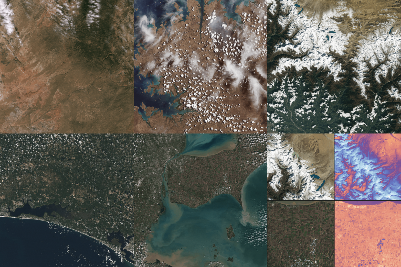
Landsat 9 First Light Images
Landsat 9 launched into space on September 27th, 2021. The "first light" images arrived on October 31st. On that day the satellite captured: algal blooms in Lake Erie, the glaciers of the Himalayas, bush fires in Australia's Eucalypt Woodlands, coastal communities on the Florida panhandle, and deserts, mountains and mesas across the Navajo Nation.
Landsat 9 launched into space on September 27th, 2021. The "first light" images arrived on October 31st. On that day the satellite captured: algal blooms in Lake Erie, the glaciers of the Himalayas, bush fires in Australia's Eucalypt Woodlands, coastal communities on the Florida panhandle, and deserts, mountains and mesas across the Navajo Nation.

Landsat Collections Screenshot
This screenshot shows what the Landsat Collections interactive looks like. This storymap collection combines all of the individual satellite storymaps into one location.
This screenshot shows what the Landsat Collections interactive looks like. This storymap collection combines all of the individual satellite storymaps into one location.

Installing natural infrastructure can impact the water and carbon budgets of dryland streams and watersheds
Installing natural infrastructure can impact the water and carbon budgets of dryland streams and watershedsAn illustration of a mountain with water flowing from the top down to a river with smaller rivers flowing off the sides. Multiple items appear along the various rivers including leaky weirs, one rock dams, log dams, gabions, check dams, trincheras, and earthen berms. Informational bubbles appear alongside these various item in the illustration.
Installing natural infrastructure can impact the water and carbon budgets of dryland streams and watersheds
Installing natural infrastructure can impact the water and carbon budgets of dryland streams and watershedsAn illustration of a mountain with water flowing from the top down to a river with smaller rivers flowing off the sides. Multiple items appear along the various rivers including leaky weirs, one rock dams, log dams, gabions, check dams, trincheras, and earthen berms. Informational bubbles appear alongside these various item in the illustration.

How Do You Landsat Overfly
An optimal opportunity for in-flight cross-calibration occurred when Landsat 9 flew underneath Landsat 8 while moving into its final orbit. Since the two satellites nearly identical imaging systems, the underfly event offered ideal cross-calibration conditions.
An optimal opportunity for in-flight cross-calibration occurred when Landsat 9 flew underneath Landsat 8 while moving into its final orbit. Since the two satellites nearly identical imaging systems, the underfly event offered ideal cross-calibration conditions.

Latest in Landsat June Newsletter
In this June 2022 issue read highlights from an international partner meeting, explore published Landsat articles, and dive into new interactive tools. Find the newsletter here: https://www.usgs.gov/latest-landsat-newsletter/latest-landsat-newslette…
In this June 2022 issue read highlights from an international partner meeting, explore published Landsat articles, and dive into new interactive tools. Find the newsletter here: https://www.usgs.gov/latest-landsat-newsletter/latest-landsat-newslette…

EoE - EMIT Mission homepage
Clockwise from lower left: Phil Brodrick, Raymond Kokaly, David Thompson of the EMIT Science Team, pictured with the logo for the USGS EROS Center podcast “Eyes on Earth.”
Clockwise from lower left: Phil Brodrick, Raymond Kokaly, David Thompson of the EMIT Science Team, pictured with the logo for the USGS EROS Center podcast “Eyes on Earth.”

Landsat: Celebrating 50 Years
Thumbnail for USGS Earth Resources Observation and Science (EROS) Center video "Landsat: Celebrating 50 Years."
Thumbnail for USGS Earth Resources Observation and Science (EROS) Center video "Landsat: Celebrating 50 Years."

TNMCorps Status Map: Volunteer Contributions through March 31, 2022
TNMCorps Status Map: Volunteer Contributions through March 31, 2022A map showing volunteer contributions from the inception of TNMCorps through March 31, 2022. Contributions are displayed by fiscal year with contributions during the current fiscal year displayed by quarter. Points are color-coded on a graduated gray-to-red scale; older points are gray and newer points are red.
TNMCorps Status Map: Volunteer Contributions through March 31, 2022
TNMCorps Status Map: Volunteer Contributions through March 31, 2022A map showing volunteer contributions from the inception of TNMCorps through March 31, 2022. Contributions are displayed by fiscal year with contributions during the current fiscal year displayed by quarter. Points are color-coded on a graduated gray-to-red scale; older points are gray and newer points are red.

TNMCorps Status Map: Standard Edited Points as of 05/02/2022
TNMCorps Status Map: Standard Edited Points as of 05/02/2022A map showing all the standard edited points as of May 2, 2022. These points need to be Peer Reviewed or checked by an Advanced Editor. They have a green border in the editor.
TNMCorps Status Map: Standard Edited Points as of 05/02/2022
TNMCorps Status Map: Standard Edited Points as of 05/02/2022A map showing all the standard edited points as of May 2, 2022. These points need to be Peer Reviewed or checked by an Advanced Editor. They have a green border in the editor.

TNMCorps Status Map: Finished Points as of 05/02/2022
TNMCorps Status Map: Finished Points as of 05/02/2022A map showing all the finished points as of May 2, 2022. These points do not need to be checked again at this time. They have a blue, purple, or yellow border in the editor.
TNMCorps Status Map: Finished Points as of 05/02/2022
TNMCorps Status Map: Finished Points as of 05/02/2022A map showing all the finished points as of May 2, 2022. These points do not need to be checked again at this time. They have a blue, purple, or yellow border in the editor.

TNMCorps Status Map: Unedited Points as of 05/02/2022
TNMCorps Status Map: Unedited Points as of 05/02/2022A map showing all the remaining unedited points as of May 2, 2022. These points need to be checked by a Standard Editor or an Advanced Editor. They have a red border in the editor.
TNMCorps Status Map: Unedited Points as of 05/02/2022
TNMCorps Status Map: Unedited Points as of 05/02/2022A map showing all the remaining unedited points as of May 2, 2022. These points need to be checked by a Standard Editor or an Advanced Editor. They have a red border in the editor.

Lidar Point Cloud of Old Faithful at Yellowstone National Park
Lidar Point Cloud of Old Faithful at Yellowstone National ParkLidar Point Cloud of Old Faithful at Yellowstone National Park with a blue to red color ramp symbology with blue representing low elevation, and red representing high elevation
Lidar Point Cloud of Old Faithful at Yellowstone National Park
Lidar Point Cloud of Old Faithful at Yellowstone National ParkLidar Point Cloud of Old Faithful at Yellowstone National Park with a blue to red color ramp symbology with blue representing low elevation, and red representing high elevation

Close Up Lidar Point Cloud of Old Faithful at Yellowstone National Park
Close Up Lidar Point Cloud of Old Faithful at Yellowstone National ParkLidar Point Cloud of Old Faithful at Yellowstone National Park with a blue to red color ramp symbology with blue representing low elevation, and red representing high elevation
Close Up Lidar Point Cloud of Old Faithful at Yellowstone National Park
Close Up Lidar Point Cloud of Old Faithful at Yellowstone National ParkLidar Point Cloud of Old Faithful at Yellowstone National Park with a blue to red color ramp symbology with blue representing low elevation, and red representing high elevation

Landsat 8 image of Karymsky volcano, April 20, 2022
Landsat 8 image of Karymsky volcano, April 20, 2022Karymsky volcano, one of the most active volcanoes of Kamchatka's eastern volcanic zone, erupted on April 20, 2022. This pan-sharpened Landsat 8 image captured the event. Overlaying the infrared data over the natural color image highlights the heat signature of the active flows.
Landsat ID: LC08_L1TP_098022_20220420_20220420_02_RT
Landsat 8 image of Karymsky volcano, April 20, 2022
Landsat 8 image of Karymsky volcano, April 20, 2022Karymsky volcano, one of the most active volcanoes of Kamchatka's eastern volcanic zone, erupted on April 20, 2022. This pan-sharpened Landsat 8 image captured the event. Overlaying the infrared data over the natural color image highlights the heat signature of the active flows.
Landsat ID: LC08_L1TP_098022_20220420_20220420_02_RT

HDYL Great Barrier Reef
The largest coral reef ecosystem in the world, the Great Barrier Reef (GBR), is threatened by many human-made impacts. Due to the size of the GBR and limited accessibility, mapping and monitoring has always been a challenging task. Remote Sensing is an effective technique that provides valuable information for the GBR ecosystem.
The largest coral reef ecosystem in the world, the Great Barrier Reef (GBR), is threatened by many human-made impacts. Due to the size of the GBR and limited accessibility, mapping and monitoring has always been a challenging task. Remote Sensing is an effective technique that provides valuable information for the GBR ecosystem.

HDYL Boreal Forest Biome
The boreal forest biome is projected to shift northward due to continued climate change over the coming century. Researchers evaluated early indicators of a boreal forest biome shift using four decades of Landsat observation datasets.
The boreal forest biome is projected to shift northward due to continued climate change over the coming century. Researchers evaluated early indicators of a boreal forest biome shift using four decades of Landsat observation datasets.

Review Queue Tab
Screenshot showing the review queue tab and window with list of points flagged for review.
Screenshot showing the review queue tab and window with list of points flagged for review.