
Image of numerous bottles of water used increasingly as an alternative drinking water source.
Images
See our science through the images below.
Filter Total Items: 3542

Image showing bottles of water.
Image of numerous bottles of water used increasingly as an alternative drinking water source.

NAS How it started vs. How it's going
A graphic created for the 2023 National Invasive Species Awareness Week social media campaign
A graphic created for the 2023 National Invasive Species Awareness Week social media campaign

Climate Connections: Avian Malaria & Hawaiian Forest Birds
Climate Connections: Avian Malaria & Hawaiian Forest BirdsAn overview of the effects of climate change on the spread of avian malaria and its subsequent impacts on Hawaiian forest birds.
Climate Connections: Avian Malaria & Hawaiian Forest Birds
Climate Connections: Avian Malaria & Hawaiian Forest BirdsAn overview of the effects of climate change on the spread of avian malaria and its subsequent impacts on Hawaiian forest birds.

Ecosystems Land Change Science Program Word Cloud 2023
Ecosystems Land Change Science Program Word Cloud 2023Word cloud of science keywords from the USGS Ecosystems Land Change Science Program. Larger words were submitted more often and from multiple projects whereas smaller words were submitted less frequently. Words in the word cloud, listed in order from largest (used most often) to smallest (used least often) and the number of times each were submitted are below:

Piping plover sitting on a nest.
A Piping Plover (Charadrius melodus) sitting on a nest. Piping Plovers breeding in the northern Great Plains, listed as Threatened since 1985, have been managed as a metapopulation consisting of four separate breeding groups with assumed infrequent movements among groups.
A Piping Plover (Charadrius melodus) sitting on a nest. Piping Plovers breeding in the northern Great Plains, listed as Threatened since 1985, have been managed as a metapopulation consisting of four separate breeding groups with assumed infrequent movements among groups.

PFAS in Select U.S. Tapwater Locations
This USGS map shows the number of PFAS detected in tap water samples from select sites across the nation. The findings are based on a USGS study of samples taken between 2016 and 2021 from private and public supplies at 716 locations. The map does not represent the only locations in the U.S. with PFAS.
This USGS map shows the number of PFAS detected in tap water samples from select sites across the nation. The findings are based on a USGS study of samples taken between 2016 and 2021 from private and public supplies at 716 locations. The map does not represent the only locations in the U.S. with PFAS.

Donovan Maude, University of Idaho graduate student, capturing white sturgeon
Donovan Maude, University of Idaho graduate student, capturing white sturgeonDonovan Maude, University of Idaho graduate student, capturing white sturgeon (Acipenser transmontanus), Snake River, Idaho. White Sturgeon is an important species, unfortunately, little is known about their population ecology and whether current monitoring metrics are adequate for evaluating management and conservation success. We are working with the U.S.

RestoreNet ConMod with flowers in the Sonoran Desert
RestoreNet ConMod with flowers in the Sonoran DesertDiverse plants growing in a connectivity modified (ConMod) treatment in the Sonoran Desert. Photo by Molly McCormick.
RestoreNet ConMod with flowers in the Sonoran Desert
RestoreNet ConMod with flowers in the Sonoran DesertDiverse plants growing in a connectivity modified (ConMod) treatment in the Sonoran Desert. Photo by Molly McCormick.

USGS scientist Mike Tate sets up the mass spectrometer to measure mercury
USGS scientist Mike Tate sets up the mass spectrometer to measure mercuryUSGS scientist Mike Tate sets up the mass spectrometer for mercury isotope measurements.
USGS scientist Mike Tate sets up the mass spectrometer to measure mercury
USGS scientist Mike Tate sets up the mass spectrometer to measure mercuryUSGS scientist Mike Tate sets up the mass spectrometer for mercury isotope measurements.
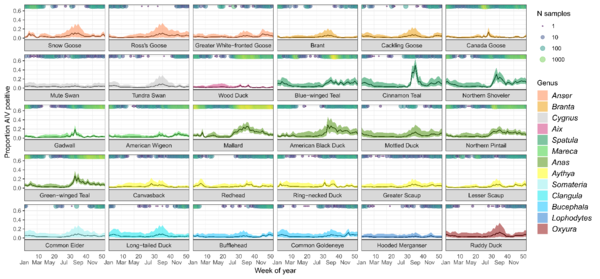
Predicted avian influenza (IAV) prevalence for 30 waterfowl species by week of year
Predicted avian influenza (IAV) prevalence for 30 waterfowl species by week of yearPercentage of individuals predicted to test positive for avian influenza virus (± 95% CI) for each species for each week ignoring spatial effects. Predictions are based on the overall prevalence values in the USDA dataset, which had a higher detection rate. Circles running along the x-axis indicate the number of samples for each species taken during that week.

"Carp"e Diem!
USGS scientist Andres Fritts holding a telemetered invasive bighead carp on the Mississippi River near Keokuk, Iowa.
USGS scientist Andres Fritts holding a telemetered invasive bighead carp on the Mississippi River near Keokuk, Iowa.

RestoreNet 2.0 restoration experiment sites with pits with seedballs on Northern Arizona rangelands
RestoreNet 2.0 restoration experiment sites with pits with seedballs on Northern Arizona rangelandsIn 2022, we piloted RestoreNet V2.0 testing soil inoculation from undegraded reference sites, seed balls (white balls in photo), and pitting treatments (small indentions). Soil inoculation with healthy soils is expected to increase beneficial microbes at the degraded restoration site. Soil microbes can help reduce water stress in plants. Photo by Hannah Farrell.

Invasive annual brome grasses filling in trail.
Invasion by annual brome grasses (cheatgrass and Japanese brome) on a trail across native prairie into National Park Service units in the Northern Great Plains.
Invasion by annual brome grasses (cheatgrass and Japanese brome) on a trail across native prairie into National Park Service units in the Northern Great Plains.

A rusty patched bumblebee visits a flower
What can you do to conserve the birds and the bees, even in the face of climate change? In some cases, small actions, such as maintaining a pollinator garden or avoiding pesticides can be important. Take the rusty patched bumble bee, once one of the most common pollinators in eastern North America.
What can you do to conserve the birds and the bees, even in the face of climate change? In some cases, small actions, such as maintaining a pollinator garden or avoiding pesticides can be important. Take the rusty patched bumble bee, once one of the most common pollinators in eastern North America.

Culex mosquito eggs
A group of controlled Culex mosquito eggs are viewed under a microscope in a California laboratory as part of an effort to mitigate avian malaria throughout the Hawaiian Islands. Image by Mia Takai
A group of controlled Culex mosquito eggs are viewed under a microscope in a California laboratory as part of an effort to mitigate avian malaria throughout the Hawaiian Islands. Image by Mia Takai
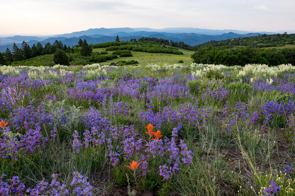
High Mesa Grassland Wilderness Study Area in Colorado
High Mesa Grassland Wilderness Study Area in ColoradoHigh Mesa Grassland Wilderness Study Area in Colorado with purple and orange wildflowers, Credit: Bob Wick, BLM.
High Mesa Grassland Wilderness Study Area in Colorado
High Mesa Grassland Wilderness Study Area in ColoradoHigh Mesa Grassland Wilderness Study Area in Colorado with purple and orange wildflowers, Credit: Bob Wick, BLM.
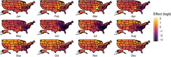
Spatial patterns in avian influenza virus (AIV) prevalence across the United States
Spatial patterns in avian influenza virus (AIV) prevalence across the United StatesMonthly realizations of the spatial random field for the continental United States, with brighter colors indicating locations within a month with relatively greater avian influenza virus prevalence. Originally published in Kent et al.
Mapping chronic wasting disease management: Identifying opportunities for intervention.
Mapping chronic wasting disease management: Identifying opportunities for intervention.This research effort is an interagency partnership between U.S. Geological Survey and U.S. Fish and Wildlife Service to model the social-ecological system that encompasses chronic wasting disease management in the United States.

Nine-banded armadillos
Nine-banded armadillos—the only armadillo species found in the United States—are distributed widely across southern states.
Nine-banded armadillos—the only armadillo species found in the United States—are distributed widely across southern states.

Polar bear walking along Beaufort Sea coast
A polar bear walking along the Beaufort Sea coast with storm waves breaking behind it, filmed during fieldwork at Barter Island, Alaska.
A polar bear walking along the Beaufort Sea coast with storm waves breaking behind it, filmed during fieldwork at Barter Island, Alaska.