



Types of Water
Types of Water
Water In Space: How Does Water Behave in Outer Space?
Glaciers: Things To Know
Rain and Precipitation
Find water science information and activities by type of water body.

Rivers, Streams, and Creeks
Rivers, Streams, and Creeks

Water quality data from state, federal, tribal, and local agencies
Filter Total Items: 168

Research Vessel David H. Peterson
The Research Vessel David H. Peterson begain service with the U.S. Geological Survey in 2015. Named after a founder of the Water Quality of San Francisco Bay Research and Monitoring Project, this vessel is a high-tech scientific platform for estuarine research. Learn more about how the R/V David H. Peterson makes our research possible.
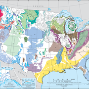
Principal Aquifers of the United States
This website compiles USGS resources and data related to principal aquifers including Aquifer Basics, principal aquifers maps and GIS data, and the National Aquifer Code Reference List.

National Aquifer Code Reference List
This list of national principal aquifer codes and names are fixed values assigned by the National Water Information System (NWIS). Aquifers are identified by a geohydrologic unit code - a three-digit number related to the age of the formation, followed by a 4 or 5 character abbreviation for the geologic unit or aquifer name.

Flood Frequency Reports
Flood-frequency analysis provides information about the magnitude and frequency of floods based on records of annual maximum instantaneous peak discharges. Accurate flood-frequency estimates, created using consistent and uniformly applied methods, are a key component of any effective flood risk and management program. This is a list of current USGS flood frequency reports published by state.

Powder River: Data for Cross-Channel Profiles at 22 Sites in Southeastern Montana, 1975 through 2019
Powder River rises in the Bighorn Mountains of Wyoming and flows northward through a semi-arid landscape in Wyoming and Montana to the Yellowstone River. The river drains an area of 34,700 square kilometers and has an average discharge of about 500 million cubic meters per year. Cross-channel profile data were collected at 22 sites on the river and its tributaries from 1975 through 2014.

USGS Blue Carbon Projects
Together with partner organizations, the USGS is involved in data collection, analysis, and synthesis to improve estimates of coastal wetland carbon fluxes. This research will help improve science and data availability across a wide range of topics.
Water Quality of San Francisco Bay Research and Monitoring Project
Since 1969, the U.S. Geological Survey has maintained a research project in the San Francisco Bay-Delta system to measure and understand how estuarine systems and tidal river deltas function and change in response to hydro-climatic variability and human activities.

Transboundary Assessments of Water Quality in the Pacific Northwest
In 2019, the USGS began studying the baseline water-quality of selected transboundary rivers in the Pacific Northwest. These studies are designed to characterize current water-quality conditions so as to facilitate future assessments of potential impacts related to upstream mining activities.

Atmospheric Warming, Loss of Snow Cover, and Declining Colorado River Flow
Declining snow cover is playing a key role in decreasing the flow of the Colorado River, “the lifeblood of the Southwest,” by enabling increased evaporation. As the warming continues, increasingly severe water shortages are expected.

International Water Resources Activities
USGS water-related projects of international interest.

SPARROW Mappers
SPARROW mappers are interactive tools that allow the user to explore river streamflow and nutrient and sediment loads and yields and the importance of different sources of contaminants in a particular river basin. Data can be visualized using maps and interactive graphs and tables, and rankings can be shown by state, major watershed, hydrologic unit (HUC), and catchment.

New Water-Quality Directions
As the USGS Water Resources Mission Area looks to the future, we are updating our water programs to meet 21st century water-resource challenges. As part of these updates, we are integrating the National Water Quality Assessment Project's water-resource monitoring, assessment, trends, modeling, and forecasting activities into new WMA programs.