
Isaac Anderson and Liz Hyde (National Innovation Center) bring in a drone for a landing, after flying a photogrammetry mission over landslide-prone terrain recently burned in the Mosquito fire (2022).
Images
The National Land Imaging Program supports a variety of geospatial data programs and projects, including the USGS Landsat Program. Browse the images below to see some of the imagery produced using NLI-supported data sources.
Filter Total Items: 501

Landing at Mosquito
Isaac Anderson and Liz Hyde (National Innovation Center) bring in a drone for a landing, after flying a photogrammetry mission over landslide-prone terrain recently burned in the Mosquito fire (2022).

Mosquito Ridge at Sunset
USGS researches and remote pilots coordinate their operations during a break in the action during a photogrammetry flight campaign in post-fire terrain in Tahoe National Forest.
USGS researches and remote pilots coordinate their operations during a break in the action during a photogrammetry flight campaign in post-fire terrain in Tahoe National Forest.

Landsat 9 Captures Mauna Loa and Kilauea Eruption
Rare spotting! Dueling volcanoes captured by Landsat 9 satellite. Mauna Loa's 11.3-mile-long lava flow illuminates the plume of ash in the atmosphere above. The small red spot in the lower right is Kilauea—it began erupting nine days ago. USGS Volcanoes says a dual eruption has not occurred in Hawaii since 1984, making this a rare event.
Rare spotting! Dueling volcanoes captured by Landsat 9 satellite. Mauna Loa's 11.3-mile-long lava flow illuminates the plume of ash in the atmosphere above. The small red spot in the lower right is Kilauea—it began erupting nine days ago. USGS Volcanoes says a dual eruption has not occurred in Hawaii since 1984, making this a rare event.

USGS scientist checking a UAS with a mounted lidar sensor at Vicksburg National Military Park
USGS scientist checking a UAS with a mounted lidar sensor at Vicksburg National Military ParkUSGS scientist Matt Burgess checking a UAS with a mounted lidar sensor at Vicksburg National Military Park
NUSO scientists, along with USGS landslide researchers, in December 2022 undertook a topographic analysis of slide-prone areas of the National Park Service Vicksburg National Military Park near Vicksburg, Mississippi.

Test Platform Sandy the Rover uses BisonCore-Vehicle Formation Programs to follow Engineer around.
Test Platform Sandy the Rover uses BisonCore-Vehicle Formation Programs to follow Engineer around.UAS Research Center BisonCore Project, using onboard autopilot systems, BisonCore on Sandy the Rover instructs the Autopilot to deviate course to follow the UAS Engineer around the parking lot. Acting like a ‘duckling’.

Eye of Hurricane Ian
On September 28, Landsat 8 passed over Hurricane Ian, capturing its eye just before landfall. The storm's center measured 42 kilometers (26 miles) wide.
On September 28, Landsat 8 passed over Hurricane Ian, capturing its eye just before landfall. The storm's center measured 42 kilometers (26 miles) wide.

Visualized plot of BisonCore’s Vehicle Formation Programs’ predictive path
Visualized plot of BisonCore’s Vehicle Formation Programs’ predictive pathUASRC BisonCore Project, using onboard systems inherent to commercial-off-the-shelf (COTS) Autopilots, BisonCore-Vehicle Formation Program predicts the path of the vehicle ahead.

Three Landsats in Space
For the first time in Landsat history, a trio of imaging satellites (Landsat 7, Landsat 8, and Landsat 9) have been recording thousands of images of the planet weekly. The trio has been working together since October 2021.
Learn more about the Landsat Program at www.usgs.gov/landsat
For the first time in Landsat history, a trio of imaging satellites (Landsat 7, Landsat 8, and Landsat 9) have been recording thousands of images of the planet weekly. The trio has been working together since October 2021.
Learn more about the Landsat Program at www.usgs.gov/landsat

Charlotte and Monroe, North Carolina
In 2022, President Joe Biden pardoned two turkeys, Chocolate and Chip. The two holiday birds hail from a ranch in Monroe, North Carolina.
In 2022, President Joe Biden pardoned two turkeys, Chocolate and Chip. The two holiday birds hail from a ranch in Monroe, North Carolina.

Saucer Shark project equipment identifying marker
Saucer Shark project equipment identifying markerUSGS NIC UASRC Saucer Shark equipment marker showing the Saucer flying over trees, with a ‘I WANT TO BELIEVE’ phrase below it.
Saucer Shark project equipment identifying marker
Saucer Shark project equipment identifying markerUSGS NIC UASRC Saucer Shark equipment marker showing the Saucer flying over trees, with a ‘I WANT TO BELIEVE’ phrase below it.

Landsat 7 Captures Hurricane Ian Aftermath
On October 2, 2022, this gap-filled Landsat 7 image captured brownish-black sediment runoff from rivers and streams on the southwest coast of Florida. These are the first Landsat images after Hurricane Ian devastated the area on Wednesday, September 28. Water runoff can carry away debris, fertilizers, metals, and other pollutants.
On October 2, 2022, this gap-filled Landsat 7 image captured brownish-black sediment runoff from rivers and streams on the southwest coast of Florida. These are the first Landsat images after Hurricane Ian devastated the area on Wednesday, September 28. Water runoff can carry away debris, fertilizers, metals, and other pollutants.

Landsat Aquatic Reflectance of Lake Erie
A Landsat 9 natural color image (left) and the corresponding Landsat Provisional Aquatic Reflectance product (right) display the properties of a massive algal bloom across the surface waters of Lake Erie on September 9, 2022.
A Landsat 9 natural color image (left) and the corresponding Landsat Provisional Aquatic Reflectance product (right) display the properties of a massive algal bloom across the surface waters of Lake Erie on September 9, 2022.

USGS and partner engineers with the NASA ER-2 aircraft
USGS and partner engineers with the NASA ER-2 aircraftLeft to Right: Trond Loke (Norsk Elektro Optikk), Isaac Anderson (USGS) and Liz Hyde (USGS) standing in front of the NASA ER-2 aircraft, during deployment to NASA Armstrong Flight Research Center, Palmdale, CA.

First natural color image from the high-altitude HySpex hyperspectral imaging sensor
First natural color image from the high-altitude HySpex hyperspectral imaging sensorNatural color image from the first flight of the high-altitude HySpex V-1240. Image is oriented with respect to true North, and is centered around Colombia, CA.

Collection 1 Datasets To Be Removed by End of 2022
Collection 1 Datasets To Be Removed by End of 2022By the end of December 2022, all Landsat Collection 1 data and science products will be removed from USGS data access platforms. This depreciation includes Level-1, Level-2, Level-3, and ESPA- related products. Collection 1 has not been updated with Landsat products since December 31, 2021.

HySpex hyperspectral imaging sensor
High-altitude version of the HySpex Mjolnir V-1240 hyperspectral imaging sensor installed in the nose of the ER-2. This assembly is specially focused for high-altitude imagery and has a lightweight housing design for use on High Altitude Long Endurance UAS.
High-altitude version of the HySpex Mjolnir V-1240 hyperspectral imaging sensor installed in the nose of the ER-2. This assembly is specially focused for high-altitude imagery and has a lightweight housing design for use on High Altitude Long Endurance UAS.
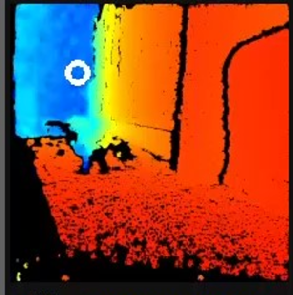
BisonCore Collision Avoidance/GPS Denied Navigation operating in hallway
BisonCore Collision Avoidance/GPS Denied Navigation operating in hallwayUSGS National Innovation Center UAS Research Center's BisonCore Project, augments an autonomous rover to navigate around obstacles through a hallway, in a GPS Denied Environment. Augmentation done through payload directed operations on data from stereo depth sensors. White circle depicts vehicle’s desired direction.

Dynamic surface water maps of Canada from 1984 to 2019 Landsat satellite imagery
Dynamic surface water maps of Canada from 1984 to 2019 Landsat satellite imageryThis paper presents dynamic surface water products over Canada from the first in a series of satellite sensors that will be used to develop a multi-sensor dynamic surface water monitoring system. The dataset uses 1984 to 2019 Landsat data to create annual water masks, inundation frequency and wetting/drying trends.

Special Issue: Landsat Update 50th Anniversary
Landsat Updates are prepared periodically and distributed electronically to provide information about Landsat activities and related topics of interest. Read this issue here.
Landsat Updates are prepared periodically and distributed electronically to provide information about Landsat activities and related topics of interest. Read this issue here.

Example of the Landsat Collection 2 Provisional Evapotranspiration science product
Example of the Landsat Collection 2 Provisional Evapotranspiration science productExample of the Landsat Collection 2 Provisional Evapotranspiration science product for agricultural fields on the Fucino plain near San Benedetto dei Marsi, Italy. Left: Landsat 9 Collection 2 Natural Color Surface Reflectance Image. Right: Landsat 9 Collection 2 Actual Evapotranspiration Image.

Landsat 9 image over Svalbard, Norway
Landsat 9 image over Svalbard, Norway. Acquired on July 8, 2022, Path 26 Row 240. For more information on Landsat data, visit the Landsat Mission Website.
Landsat 9 image over Svalbard, Norway. Acquired on July 8, 2022, Path 26 Row 240. For more information on Landsat data, visit the Landsat Mission Website.