
A Model to Predict Sediment Bulk Density in the San Francisco Estuary
Oceanographic Instrumentation Detects Layers of Plankton Migration off Puerto Rico
Comparing Nearly 40 years of Satellite-derived Shorelines with Traditional Shoreline Measurements
Coastal Observing Cameras at America's Northernmost Point Decommissioned Due to Coastal Erosion
Impact of warming and suspended land-based sediment on Hawaiian reef corals
Hawaiʻi Abyssal Nodules and Associated Ecosystems Expedition
Defining the Anthropocene via the transport of invasive species
Sediment contaminants in Puget Sound: Implications for ecosystem health and remediation
Seasonal erosion and accretion in a San Francisco Bay marsh
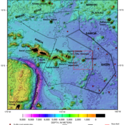
New seafloor mapping offshore Kodiak Island, Alaska, reveals extensive submarine landslides
Land-based nutrient flux to a fringing reef: insights from Ofu Island, American Samoa
Frequency and Intensity of Storm Surges Underestimated Nationally, Study Finds
Pacific Coastal and Marine Science Center
PCMSC is one of three centers serving the mission of the USGS Coastal and Marine Hazards and Resources Program—the primary Federal marine geology and physical science research program responsible for the Nation’s entire coastal and marine landscape.
What We Do: Coastal and Marine Science at USGS Santa Cruz
What We Do: Coastal and Marine Science at USGS Santa Cruz

Get an overview of the coastal and marine research conducted by the USGS in Santa Cruz, California in our downloadable booklet.
Research Projects
Research Projects

Read about our science projects, find out where we are working, and discover the reasons why our research matters.
News
USGS Releases Global 3D Archive of Coral Reef Cores to Support Climate and Coastal Research
USGS Releases Global 3D Archive of Coral Reef Cores to Support Climate and Coastal Research
Linking climate variability to shoreline change in the Pacific Northwest
Linking climate variability to shoreline change in the Pacific Northwest
Ozette Lake: A natural seismograph along the northern Cascadia Subduction Zone (Video)
Ozette Lake: A natural seismograph along the northern Cascadia Subduction Zone (Video)
Publications
Interplay between tectonics and submarine mass transport deposits in Cortes Basin: New high-resolution geophysics in the Outer California Borderland Interplay between tectonics and submarine mass transport deposits in Cortes Basin: New high-resolution geophysics in the Outer California Borderland
The Outer California Borderland (OCB) is an active transform plate boundary offshore Southern California, where the relationship between faulting and submarine mass transport deposits (MTDs) remains poorly understood. Onshore paleoseismic data provide high-resolution earthquake records, whereas marine geophysical data capture longer-term histories. Offshore fault systems pose hazards to
Frameworks for assessing tsunami hazard and risk Frameworks for assessing tsunami hazard and risk
Tsunamis are multiscale phenomena resulting from a water column displacement that may be induced by multiple sources, and range from local scale inundation processes to ocean-wide scale wave propagation. Different strategies may be required to model tsunami evolution at different scales and to characterize various intensity measures. Research in tsunami hazard and risk has focused mostly...
The biosphere in the Anthropocene The biosphere in the Anthropocene
Earth’s biosphere is in a period of rapid change, resulting from anthropogenic pressures such as climate change, habitat loss and species translocation and extinction. The extraordinary pace of change has led to the suggestion that we live in a new geological epoch of time called the Anthropocene. In this theme issue, we explore the major changes to the terrestrial and marine biospheres...
Science

Geologic Mapping for Landscape Resiliency in California, Oregon, and Washington
This project uses geologic and geomorphic mapping in the context of societally relevant problems in the Earth’s critical zone. Leveraging interdisciplinary research ties and interagency collaborations, it utilizes remote sensing data, corroborated with field observations, to determine i) the spatial distribution of geomorphic processes and ages of Quaternary deposits in the context of active...
By
Earthquake Hazards Program, Landslide Hazards Program, National Cooperative Geologic Mapping Program, Earthquake Science Center, Geologic Hazards Science Center, Geology, Minerals, Energy, and Geophysics Science Center, Geosciences and Environmental Change Science Center, Pacific Coastal and Marine Science Center, Big Sur Landslides
American Samoa Mapping Project
USGS scientists are leading a sampling effort to the Samoan Basin, offshore of American Samoa. This work is part of an interagency supported three-month hydrograph survey project led by NOAA and in partnership with BOEM.
Where Land Meets Sea: USGS Science for Resilient Coastal Habitats
USGS coastal science plays a critical role in supporting the effective, science-based management of coastal ecosystems, where the biodiversity of land and sea meet. It provides managers with the information they need to make sound decisions. Through cutting-edge research, predictive modeling, and decision-support tools, USGS empowers resource managers to make informed, science-based choices. From...
By
Ecosystems Mission Area, Land Management Research Program, California Water Science Center, Eastern Ecological Science Center, Forest and Rangeland Ecosystem Science Center, Lower Mississippi-Gulf Water Science Center, Pacific Coastal and Marine Science Center, Western Ecological Research Center (WERC), Western Fisheries Research Center, Western Geographic Science Center, Wetland and Aquatic Research Center