An official website of the United States government
Here's how you know
Official websites use .gov
A .gov website belongs to an official government organization in the United States.
Secure .gov websites use HTTPS
A lock () or https:// means you’ve safely connected to the .gov website. Share sensitive information only on official, secure websites.
Landsat 9 is a partnership between the U.S. Geological Survey (USGS) and the National Aeronautics and Space Administration (NASA) and continues the Landsat program’s critical role of repeat global observations for monitoring, understanding, and managing Earth’s natural resources.
Landsat 9 launched into space on September 27, 2021. The "first light" images arrived on October 31st. Click to learn more about these images.
Since 1972, Landsat data provide a unique resource for those who work in agriculture, geology, forestry, regional planning, education, mapping, and global change research. Landsat images also prove invaluable to the International Charter: Space and Major Disasters, supporting emergency response and disaster relief to save lives. With the addition of Landsat 9, the Landsat program’s record of land imaging extends to over half a century.
Landsat 9 captured five first light images: the Himalayas of Nepal, the Navajo Nation in the Western United States, the inlets of the Kimberly region of Western Australia, the Pensacola Beach on the Florida Panhandle, and the Lake Erie near Detroit, Michigan and Ontario, Canada.
Landsat 9 carries the Operational Land Imager(OLI), built by Ball Aerospace & Technologies Corporation, Boulder, Colorado, and the Thermal Infrared Sensor (TIRS), built at the NASA Goddard Space Flight Center, Greenbelt, Maryland. Northrop Grumman designed and fabricated the spacecraft and integrated the two instruments.
NASA was responsible for the space segment (the instruments and spacecraft/observatory), mission integration, launch, and on-orbit checkout. After the satellite reached orbit, an official checkout turned responsibility to the USGS, to manage the ground system, flight operations, data processing, data product archive and distribution.
Spacecraft and Launch Components
Spacecraft Provider: Northrop Grumman
Spacecraft Bus: Northrop Grumman Innovation Systems (formerly Orbital ATK)
Launch Vehicle: United Launch Alliance Atlas V 401
Spacecraft Speed: 16,760 miles/hr (26,972 km/hr)
Design Life: 5 years
Consumables: 10 years
Orbits the Earth in a sun-synchronous, near-polar orbit (98.2 degrees inclination)
Achieved an altitude of 705 km (438 mi)
Completes one Earth orbit every 99 minutes
Has a 16-day repeat cycle with an equatorial crossing time of 10:12 a.m. +/- 5 minutes
8-day offset with Landsat 8
Acquires about 750 scenes a day on the Worldwide Reference System-2 (WRS-2) path/row system, with a swath overlap (or sidelap) varying from 7 percent at the equator to a maximum of approximately 85 percent at extreme latitudes
The instruments onboard Landsat 9 are improved replicas of those collecting data onboard Landsat 8, which are already providing data that is radiometrically and geometrically superior than instruments on previous generation Landsat satellites.
The satellite carries two science instruments, the Operational Land Imager (OLI) and the Thermal Infrared Sensor (TIRS). The OLI captures observations of the Earth’s surface in visible, near-infrared, and shortwave-infrared bands, and TIRS measures thermal infrared radiation, or heat, emitted from the Earth’s surface. Both OLI and TIRS have a 5-year mission design life, although the spacecraft has 10+ years of consumables.
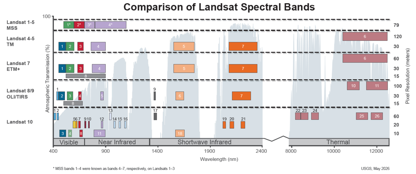
Landsat 9 improvements include higher radiometric resolution for OLI (14-bit quantization increased from 12-bits for Landsat 8) allowing sensors to detect more subtle differences, especially over darker areas such as water or dense forests. With the higher radiometric resolution, Landsat 9 can differentiate 16,384 shades of a given wavelength. In comparison, Landsat 8 provides 12-bit data and 4,096 shades, and Landsat 7 detects only 256 shades with its 8-bit resolution. In addition to the OLI improvement, TIRS has significantly reduced stray light compared to the Landsat 8 Thermal Infrared Sensor (TIRS) which enables improved atmospheric correction and more accurate surface temperature measurements..
Operational Land Imager (OLI)
Landsat 9's OLI is a copy of that on Landsat 8, and provides imagery consistent with previous Landsat spectral, spatial, radiometric and geometric qualities. OLI will provide data for nine spectral bands with a maximum ground sampling distance (GSD), both in-track and cross track, of 30-meters(m) (98 feet) for all bands except the panchromatic band, which has a 15-meter (49 feet) GSD. OLI provides both internal calibration sources to ensure radiometric accuracy and stability, as well as the ability to perform solar and lunar calibrations. OLI is designed by Ball Aerospace in Boulder, Colorado.
Nine spectral bands:
Band 1 Visible Coastal Aerosol (0.43 - 0.45 µm) 30-m
Band 2 Visible Blue (0.450 - 0.51 µm) 30-m
Band 3 Visible Green (0.53 - 0.59 µm) 30-m
Band 4 Red (0.64 - 0.67 µm) 30-m
Band 5 Near-Infrared (0.85 - 0.88 µm) 30-m
Band 6 SWIR 1(1.57 - 1.65 µm) 30-m
Band 7 SWIR 2 (2.11 - 2.29 µm) 30-m
Band 8 Panchromatic (PAN) (0.50 - 0.68 µm) 15-m
Band 9 Cirrus (1.36 - 1.38 µm) 30-m
Thermal Infrared Sensor (TIRS)
Landsat 9’s Thermal Infrared Sensor (TIRS) measures thermal radiance emitted from the land surface in two thermal infrared bands using the same technology that was used for TIRS on Landsat 8, however TIRS is an improved version of Landsat 8’s TIRS, both with regards to instrument risk class and design to minimize stray light. TIRS provides two spectral bands with a maximum ground sampling distance, both in-track and cross track, of 100 m (328 ft) for both bands. TIRS provides an internal blackbody calibration source as well as space view capabilities. TIRS is designed by NASA Goddard Space Flight Center in Greenbelt, Maryland.
This image shows the bandpass wavelengths for the Landsat 1-9 sensors. *Landsat MSS = the numbers shown are for Landsat 4 and Landsat 5; Landsat 1-3 band numbers are 4, 5, 6 and 7.
Landsat 9 Data Products
Data acquired by Landsat 9 is processed into the Landsat Collection 2 inventory structure in the Worldwide Reference System-2 (WRS-2) path/row system, with swath overlap (or sidelap) varying from 7 percent at the Equator to a maximum of approximately 85 percent at extreme latitudes.
Landsat 9 collects as many as 750 scenes per day, and with Landsat 8, the two satellites add nearly 1,500 new scenes a day to the USGS Landsat archive. Landsat 9 increases the volume of the USGS archive by imaging all global landmasses and nearshore coastal regions, including islands at solar elevation angles greater than 5 degrees that were not always routinely collected prior to Landsat 8.
All Landsat 9 data and products are available for download through the USGS Earth Resources Observation and Science (EROS) Center at no charge.
Papers about Landsat 9's Pre-launch, Commissioning, and Early On-Orbit Imaging Performance Published in Science Journal
A new Remote Sensing Special Issue contains information on the calibration and validation activities performed on Landsat 9 instruments to ensure the gold standard of geometric, radiometric, spatial, and spectral resolutions are upheld for delivering the expected data quality. Topics in the special issue include pre-launch characterization, testing, commissioning, and early on-orbit performance for the OLI and TIRS instrument and Landsat 9 spacecraft. Visit the Remote Sensing webpage to access the papers in this issue.
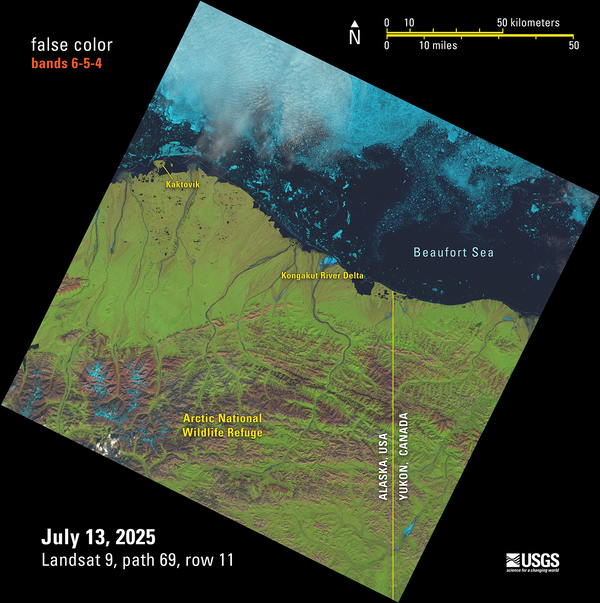
Landsat 9 False Color Image of the Beaufort Sea Shoreline
This Landsat 9 image showing the Beaufort Sea shoreline off of Alaska and Canada is just one of the scenes captured and processed on July 13, 2025— that day, the USGS EROS archive reached a milestone of one million Landsat 9 Level-1 products. This false color image was made with bands 6,5, and 4 from the Operational Land Imager.
This Landsat 9 image showing the Beaufort Sea shoreline off of Alaska and Canada is just one of the scenes captured and processed on July 13, 2025— that day, the USGS EROS archive reached a milestone of one million Landsat 9 Level-1 products. This false color image was made with bands 6,5, and 4 from the Operational Land Imager.
Landsat 9 Image of the Greater Los Angeles Fires - January 14, 2025 (During)
The tragic fires sweeping across the Greater Los Angeles area in January 2025 have burned more than 40,000 acres, destroyed more than 12,300 structures, and prompted evacuation orders and warnings for as many as 200,000 residents. Exceptionally dry conditions, coupled with strong Santa Ana winds, have fueled the fires.
The tragic fires sweeping across the Greater Los Angeles area in January 2025 have burned more than 40,000 acres, destroyed more than 12,300 structures, and prompted evacuation orders and warnings for as many as 200,000 residents. Exceptionally dry conditions, coupled with strong Santa Ana winds, have fueled the fires.
Landsat 9 Sees Diverse Landscapes of the Desert Southwest
The USGS EROS Landsat archive recently reached a milestone of 12 million Landsat Collection 2 Level-1 products. These are available for download at no charge. The image representing this milestone displays a sprawling desert landscape and contains a multitude of agricultural, geological, and urban features.
The USGS EROS Landsat archive recently reached a milestone of 12 million Landsat Collection 2 Level-1 products. These are available for download at no charge. The image representing this milestone displays a sprawling desert landscape and contains a multitude of agricultural, geological, and urban features.
Landsat 8 and Landsat 9 kicked off 2025 by acquiring over 1,400 scenes on the first of January. This Landsat 9 image of Emi Koussi in the Tibesti Range of Chad is a mosaic of two of the many scenes collected. Emi Koussi is an extinct shield volcano that rises to 11,204 feet (3,415 meters) above sea level, making it the highest summit in Chad and the Sahara Desert.
Landsat 8 and Landsat 9 kicked off 2025 by acquiring over 1,400 scenes on the first of January. This Landsat 9 image of Emi Koussi in the Tibesti Range of Chad is a mosaic of two of the many scenes collected. Emi Koussi is an extinct shield volcano that rises to 11,204 feet (3,415 meters) above sea level, making it the highest summit in Chad and the Sahara Desert.
Landsat 9 image of irrigated cropland in northeast Nebraska 2024
The green circles in this Landsat 9 image display irrigated cropland in northeast Nebraska during the 2024 growing season. This area is well known for corn and soybeans but also produces potatoes. (Ref: https://croplandcros.scinet.usda.gov/)
The green circles in this Landsat 9 image display irrigated cropland in northeast Nebraska during the 2024 growing season. This area is well known for corn and soybeans but also produces potatoes. (Ref: https://croplandcros.scinet.usda.gov/)
Landsat 9 image of eutrophication in Lake Thompson, South Dakota
A September 20, 2024, Landsat 9 satellite image of eutrophication in Lake Thompson, South Dakota. Eutrophication because of phosphate fertilizer use is probably one of the most notable impacts on the environment, society and the economy.
A September 20, 2024, Landsat 9 satellite image of eutrophication in Lake Thompson, South Dakota. Eutrophication because of phosphate fertilizer use is probably one of the most notable impacts on the environment, society and the economy.
The Park Fire north of Sacramento in California forced thousands of residents to evacuate in late July as it spread to over 370,000 acres. The fire started on July 24th. Landsat 8 captured an image of the fire two days later.
The Park Fire north of Sacramento in California forced thousands of residents to evacuate in late July as it spread to over 370,000 acres. The fire started on July 24th. Landsat 8 captured an image of the fire two days later.
The Phoenix, Arizona metropolitan area, also known as the Valley of the Sun, is comprised of more than 14,600 square miles and is considered the largest metropolitan area in the southwestern United States. The desert climate and abundant sunshine of the area are main factors in population growth and urban sprawl.
The Phoenix, Arizona metropolitan area, also known as the Valley of the Sun, is comprised of more than 14,600 square miles and is considered the largest metropolitan area in the southwestern United States. The desert climate and abundant sunshine of the area are main factors in population growth and urban sprawl.
The Railroad Valley Playa, located in east central Nevada, measures about 80 miles long and nearly 20 miles wide, and is a vast and wide-open landscape.
The Railroad Valley Playa, located in east central Nevada, measures about 80 miles long and nearly 20 miles wide, and is a vast and wide-open landscape.
This Landsat 9 image from June 13, 2024, shows the Beaufort Sea near Prudhoe Bay, Alaska, using the Shortwave Infrared, Near Infrared, and Reds (Band 6|5|4), and sharpened with the with Panchromatic band (Band 8). The cyan tones highlight sea ice and melt ponds, while the red areas represent land and vegetation.
This Landsat 9 image from June 13, 2024, shows the Beaufort Sea near Prudhoe Bay, Alaska, using the Shortwave Infrared, Near Infrared, and Reds (Band 6|5|4), and sharpened with the with Panchromatic band (Band 8). The cyan tones highlight sea ice and melt ponds, while the red areas represent land and vegetation.
In November 2023 the Svartsengi volcanic system awakened after almost 800 years with a series of earthquakes that opened large cracks in the on Iceland’s Reykjanes Peninsula. An eruption on December 18th spewed lava away from the nearby coastal town of Grindavik, but the January 14, 2024 eruption sent lava directly toward the town.
In November 2023 the Svartsengi volcanic system awakened after almost 800 years with a series of earthquakes that opened large cracks in the on Iceland’s Reykjanes Peninsula. An eruption on December 18th spewed lava away from the nearby coastal town of Grindavik, but the January 14, 2024 eruption sent lava directly toward the town.
In November 2023 the Svartsengi volcanic system awakened after almost 800 years with a series of earthquakes that opened large cracks in the on Iceland’s Reykjanes Peninsula. An eruption on December 18th spewed lava away from the nearby coastal town of Grindavik, but the January 14, 2024 eruption sent lava directly toward the town.
In November 2023 the Svartsengi volcanic system awakened after almost 800 years with a series of earthquakes that opened large cracks in the on Iceland’s Reykjanes Peninsula. An eruption on December 18th spewed lava away from the nearby coastal town of Grindavik, but the January 14, 2024 eruption sent lava directly toward the town.
Landsat 9 image of Snæfellsjökull and Snæfellsnes Peninsula in west Iceland
Landsat 9 captured this image of Snæfellsjökull, a glacier-capped volcano that sits at the tip of the Snæfellsnes Peninsula in west Iceland on August 9, 2023.
Landsat 9 captured this image of Snæfellsjökull, a glacier-capped volcano that sits at the tip of the Snæfellsnes Peninsula in west Iceland on August 9, 2023.
Landsat 9 image of Northeastern Queensland, Australia
This Landsat 9 image displaying the coastline of Northeastern Queensland, Australia and the Cumberland Islands was acquired on July 1, and reprocessed on July 12, 2023.
This Landsat 9 image displaying the coastline of Northeastern Queensland, Australia and the Cumberland Islands was acquired on July 1, and reprocessed on July 12, 2023.
During the early post-launch phase of the Landsat 9 mission, the Landsat 8 and 9 mission teams conducted a successful under-fly of Landsat 8 by Landsat 9, allowing for the near-simultaneous data collection of common Earth targets by the on-board sensors for cross-calibration. This effort, coordinated by the Landsat Calibration and Validation team, required contributions from various...
Authors
Edward Kaita, Brian Markham, Md Obaidul Haque, Donald Dichmann, Aaron Gerace, Lawrence Leigh, Susan Good, Michael Schmidt, Christopher J. Crawford
The Landsat program has a long history of providing remotely sensed data to the user community. This history is being extended with the addition of the Landsat 9 satellite, which closely mimics the Landsat 8 satellite and its instruments. These satellites contain two instruments, the Operational Land Imager (OLI) and the Thermal Infrared Sensor (TIRS). OLI is a push-broom sensor that...
Authors
Michael J. Choate, Rajagopalan Rengarajan, James C. Storey, Mark Lubke
Landsat 9 is in its final preparations for launch from Vandenberg Space Force Base on 16 September 2021. It has completed its environmental testing at Northrop Grumman Space (NGSP) in Gilbert, Arizona and has been transported to its California launch site. It will be launched into a 705 km orbit replacing Landsat 7 to provide 8-day Earth land mass coverage in concert with Landsat 8...
Authors
Brian Markham, Cody Anderson, Michael J. Choate, Christopher J. Crawford, Del Jenstrom, Jeff Masek, Jeffery Pedelty, Brian Sauer, Kurtis Thome
The history of Earth observation from space is well reflected through the Landsat program. With data collection beginning with Landsat-1 in 1972, the program has evolved technical capabilities while maintaining continuity of land observations. In so doing, Landsat has provided a critical reference for assessing long-term changes to Earth's land environment due to both natural and human...
Authors
Jeffery G. Masek, Michael A. Wulder, Brian Markham, Joel McCorkel, Christopher J. Crawford, James C. Storey, Del Jenstrom
Landsat 9 is a partnership between the National Aeronautics and Space Administration and the U.S. Geological Survey that will continue the Landsat program’s critical role of repeat global observations for monitoring, understanding, and managing Earth’s natural resources. Since 1972, Landsat data have provided a unique resource for those who work in agriculture, geology, forestry...
Landsat 9 launched September 27, 2021, to acquire images of Earth, extending Landsat's record of our planet to over half a century. Learn more about the mission.
Over the course of fifty years, eight Landsat satellites have observed the Earth's surface. This storymap collection allows users to view each satellite's heritage from Landsat 1 through Landsat 9 (Landsat 6 did not achieve orbit). See first light images, significant events, and unique science for each satellite.
Launched on September 27th, 2021, Landsat 9 is a partnership between NASA and the U.S. Geological Survey. Learn about the process of building Landsat 9 and how it will extend Landsat's unbroken record of our planet to over half a century.
All Landsat 9 Collection 2 Operational Land Imager (OLI) and Thermal Infrared Sensor (TIRS) data will be reprocessed at the end of 2022 to take advantage of calibration updates identified during the first year of operation.
The Operational Land Imager’s Band 9 1.360-1.390 µm on Landsat 8 and Landsat 9 detects thin, high-altitude clouds composed of ice crystals that might not be visible in other spectral bands. In Band 9, cirrus clouds appear bright while most land surfaces appear dark through an otherwise cloud-free atmosphere containing water vapor. Learn more: Landsat 8 Mission Landsat 9 Mission Landsat 8 & 9 bands...
How is the Landsat 8 and Landsat 9 Cirrus Band 9 used?
The Operational Land Imager’s Band 9 1.360-1.390 µm on Landsat 8 and Landsat 9 detects thin, high-altitude clouds composed of ice crystals that might not be visible in other spectral bands. In Band 9, cirrus clouds appear bright while most land surfaces appear dark through an otherwise cloud-free atmosphere containing water vapor. Learn more: Landsat 8 Mission Landsat 9 Mission Landsat 8 & 9 bands...
The Operational Land Imager Band 1 ( 0.433-0.453 µm) on Landsat 8 and Landsat 9 is useful for imaging shallow water and tracking fine atmospheric particles like dust and smoke. Band 1 reflects blues and violets, where light is scattered by dust, smoke, and water particles in the air. Collecting data with enough sensitivity at this spectrum is difficult. Since water absorbs and scatters light...
How is the Landsat 8 and Landsat 9 Coastal/Aerosol Band 1 used?
The Operational Land Imager Band 1 ( 0.433-0.453 µm) on Landsat 8 and Landsat 9 is useful for imaging shallow water and tracking fine atmospheric particles like dust and smoke. Band 1 reflects blues and violets, where light is scattered by dust, smoke, and water particles in the air. Collecting data with enough sensitivity at this spectrum is difficult. Since water absorbs and scatters light...
Landsat 9 carries the same instruments that are on the Landsat 8 satellite but with some improvements: Operational Land Imager (OLI) for reflective band data. Thermal Infrared Sensor (TIRS) for the thermal infrared bands. OLI has a slightly improved signal-to-noise ratio over Landsat 8's OLI. Landsat 9’s TIRS is a Class-B instrument with a five-year design life and a key improvement of stray light...
Landsat 9 carries the same instruments that are on the Landsat 8 satellite but with some improvements: Operational Land Imager (OLI) for reflective band data. Thermal Infrared Sensor (TIRS) for the thermal infrared bands. OLI has a slightly improved signal-to-noise ratio over Landsat 8's OLI. Landsat 9’s TIRS is a Class-B instrument with a five-year design life and a key improvement of stray light...
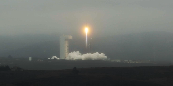
Landsat 9—a partnership between the USGS and NASA—was launched from Space Launch Complex 3E at Vandenberg Air Force Base in California upon a United Launch Alliance Atlas V 401 launch vehicle on September 27, 2021. Learn more: Landsat 9 Mission
Landsat 9—a partnership between the USGS and NASA—was launched from Space Launch Complex 3E at Vandenberg Air Force Base in California upon a United Launch Alliance Atlas V 401 launch vehicle on September 27, 2021. Learn more: Landsat 9 Mission
Landsat 9 False Color Image of the Beaufort Sea Shoreline
This Landsat 9 image showing the Beaufort Sea shoreline off of Alaska and Canada is just one of the scenes captured and processed on July 13, 2025— that day, the USGS EROS archive reached a milestone of one million Landsat 9 Level-1 products. This false color image was made with bands 6,5, and 4 from the Operational Land Imager.
This Landsat 9 image showing the Beaufort Sea shoreline off of Alaska and Canada is just one of the scenes captured and processed on July 13, 2025— that day, the USGS EROS archive reached a milestone of one million Landsat 9 Level-1 products. This false color image was made with bands 6,5, and 4 from the Operational Land Imager.
Landsat 9 Image of the Greater Los Angeles Fires - January 14, 2025 (During)
The tragic fires sweeping across the Greater Los Angeles area in January 2025 have burned more than 40,000 acres, destroyed more than 12,300 structures, and prompted evacuation orders and warnings for as many as 200,000 residents. Exceptionally dry conditions, coupled with strong Santa Ana winds, have fueled the fires.
The tragic fires sweeping across the Greater Los Angeles area in January 2025 have burned more than 40,000 acres, destroyed more than 12,300 structures, and prompted evacuation orders and warnings for as many as 200,000 residents. Exceptionally dry conditions, coupled with strong Santa Ana winds, have fueled the fires.
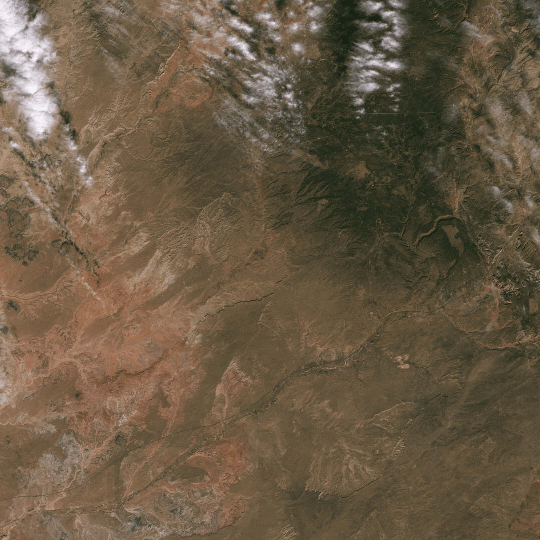
Landsat 9 Sees Diverse Landscapes of the Desert Southwest
The USGS EROS Landsat archive recently reached a milestone of 12 million Landsat Collection 2 Level-1 products. These are available for download at no charge. The image representing this milestone displays a sprawling desert landscape and contains a multitude of agricultural, geological, and urban features.
The USGS EROS Landsat archive recently reached a milestone of 12 million Landsat Collection 2 Level-1 products. These are available for download at no charge. The image representing this milestone displays a sprawling desert landscape and contains a multitude of agricultural, geological, and urban features.
Landsat 8 and Landsat 9 kicked off 2025 by acquiring over 1,400 scenes on the first of January. This Landsat 9 image of Emi Koussi in the Tibesti Range of Chad is a mosaic of two of the many scenes collected. Emi Koussi is an extinct shield volcano that rises to 11,204 feet (3,415 meters) above sea level, making it the highest summit in Chad and the Sahara Desert.
Landsat 8 and Landsat 9 kicked off 2025 by acquiring over 1,400 scenes on the first of January. This Landsat 9 image of Emi Koussi in the Tibesti Range of Chad is a mosaic of two of the many scenes collected. Emi Koussi is an extinct shield volcano that rises to 11,204 feet (3,415 meters) above sea level, making it the highest summit in Chad and the Sahara Desert.
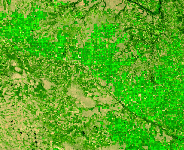
Landsat 9 image of irrigated cropland in northeast Nebraska 2024
The green circles in this Landsat 9 image display irrigated cropland in northeast Nebraska during the 2024 growing season. This area is well known for corn and soybeans but also produces potatoes. (Ref: https://croplandcros.scinet.usda.gov/)
The green circles in this Landsat 9 image display irrigated cropland in northeast Nebraska during the 2024 growing season. This area is well known for corn and soybeans but also produces potatoes. (Ref: https://croplandcros.scinet.usda.gov/)
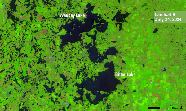
Landsat 9 image of eutrophication in Lake Thompson, South Dakota
A September 20, 2024, Landsat 9 satellite image of eutrophication in Lake Thompson, South Dakota. Eutrophication because of phosphate fertilizer use is probably one of the most notable impacts on the environment, society and the economy.
A September 20, 2024, Landsat 9 satellite image of eutrophication in Lake Thompson, South Dakota. Eutrophication because of phosphate fertilizer use is probably one of the most notable impacts on the environment, society and the economy.
The Park Fire north of Sacramento in California forced thousands of residents to evacuate in late July as it spread to over 370,000 acres. The fire started on July 24th. Landsat 8 captured an image of the fire two days later.
The Park Fire north of Sacramento in California forced thousands of residents to evacuate in late July as it spread to over 370,000 acres. The fire started on July 24th. Landsat 8 captured an image of the fire two days later.
The Phoenix, Arizona metropolitan area, also known as the Valley of the Sun, is comprised of more than 14,600 square miles and is considered the largest metropolitan area in the southwestern United States. The desert climate and abundant sunshine of the area are main factors in population growth and urban sprawl.
The Phoenix, Arizona metropolitan area, also known as the Valley of the Sun, is comprised of more than 14,600 square miles and is considered the largest metropolitan area in the southwestern United States. The desert climate and abundant sunshine of the area are main factors in population growth and urban sprawl.
The Railroad Valley Playa, located in east central Nevada, measures about 80 miles long and nearly 20 miles wide, and is a vast and wide-open landscape.
The Railroad Valley Playa, located in east central Nevada, measures about 80 miles long and nearly 20 miles wide, and is a vast and wide-open landscape.
This Landsat 9 image from June 13, 2024, shows the Beaufort Sea near Prudhoe Bay, Alaska, using the Shortwave Infrared, Near Infrared, and Reds (Band 6|5|4), and sharpened with the with Panchromatic band (Band 8). The cyan tones highlight sea ice and melt ponds, while the red areas represent land and vegetation.
This Landsat 9 image from June 13, 2024, shows the Beaufort Sea near Prudhoe Bay, Alaska, using the Shortwave Infrared, Near Infrared, and Reds (Band 6|5|4), and sharpened with the with Panchromatic band (Band 8). The cyan tones highlight sea ice and melt ponds, while the red areas represent land and vegetation.
In November 2023 the Svartsengi volcanic system awakened after almost 800 years with a series of earthquakes that opened large cracks in the on Iceland’s Reykjanes Peninsula. An eruption on December 18th spewed lava away from the nearby coastal town of Grindavik, but the January 14, 2024 eruption sent lava directly toward the town.
In November 2023 the Svartsengi volcanic system awakened after almost 800 years with a series of earthquakes that opened large cracks in the on Iceland’s Reykjanes Peninsula. An eruption on December 18th spewed lava away from the nearby coastal town of Grindavik, but the January 14, 2024 eruption sent lava directly toward the town.
In November 2023 the Svartsengi volcanic system awakened after almost 800 years with a series of earthquakes that opened large cracks in the on Iceland’s Reykjanes Peninsula. An eruption on December 18th spewed lava away from the nearby coastal town of Grindavik, but the January 14, 2024 eruption sent lava directly toward the town.
In November 2023 the Svartsengi volcanic system awakened after almost 800 years with a series of earthquakes that opened large cracks in the on Iceland’s Reykjanes Peninsula. An eruption on December 18th spewed lava away from the nearby coastal town of Grindavik, but the January 14, 2024 eruption sent lava directly toward the town.
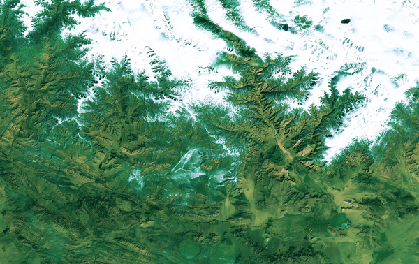
Landsat 9 image of Snæfellsjökull and Snæfellsnes Peninsula in west Iceland
Landsat 9 captured this image of Snæfellsjökull, a glacier-capped volcano that sits at the tip of the Snæfellsnes Peninsula in west Iceland on August 9, 2023.
Landsat 9 captured this image of Snæfellsjökull, a glacier-capped volcano that sits at the tip of the Snæfellsnes Peninsula in west Iceland on August 9, 2023.
Landsat 9 image of Northeastern Queensland, Australia
This Landsat 9 image displaying the coastline of Northeastern Queensland, Australia and the Cumberland Islands was acquired on July 1, and reprocessed on July 12, 2023.
This Landsat 9 image displaying the coastline of Northeastern Queensland, Australia and the Cumberland Islands was acquired on July 1, and reprocessed on July 12, 2023.
During the early post-launch phase of the Landsat 9 mission, the Landsat 8 and 9 mission teams conducted a successful under-fly of Landsat 8 by Landsat 9, allowing for the near-simultaneous data collection of common Earth targets by the on-board sensors for cross-calibration. This effort, coordinated by the Landsat Calibration and Validation team, required contributions from various...
Authors
Edward Kaita, Brian Markham, Md Obaidul Haque, Donald Dichmann, Aaron Gerace, Lawrence Leigh, Susan Good, Michael Schmidt, Christopher J. Crawford
The Landsat program has a long history of providing remotely sensed data to the user community. This history is being extended with the addition of the Landsat 9 satellite, which closely mimics the Landsat 8 satellite and its instruments. These satellites contain two instruments, the Operational Land Imager (OLI) and the Thermal Infrared Sensor (TIRS). OLI is a push-broom sensor that...
Authors
Michael J. Choate, Rajagopalan Rengarajan, James C. Storey, Mark Lubke
Landsat 9 is in its final preparations for launch from Vandenberg Space Force Base on 16 September 2021. It has completed its environmental testing at Northrop Grumman Space (NGSP) in Gilbert, Arizona and has been transported to its California launch site. It will be launched into a 705 km orbit replacing Landsat 7 to provide 8-day Earth land mass coverage in concert with Landsat 8...
Authors
Brian Markham, Cody Anderson, Michael J. Choate, Christopher J. Crawford, Del Jenstrom, Jeff Masek, Jeffery Pedelty, Brian Sauer, Kurtis Thome
The history of Earth observation from space is well reflected through the Landsat program. With data collection beginning with Landsat-1 in 1972, the program has evolved technical capabilities while maintaining continuity of land observations. In so doing, Landsat has provided a critical reference for assessing long-term changes to Earth's land environment due to both natural and human...
Authors
Jeffery G. Masek, Michael A. Wulder, Brian Markham, Joel McCorkel, Christopher J. Crawford, James C. Storey, Del Jenstrom
The history of Earth observation from space is well reflected through the Landsat program. With data collection beginning with Landsat-1 in 1972, the program has evolved technical capabilities while maintaining continuity of land observations. In so doing, Landsat has provided a critical reference for assessing long-term changes to Earth's land environment due to both natural and human...
Authors
Jeffery G. Masek, Michael A. Wulder, Brian Markham, Joel McCorkel, Christopher J. Crawford, James C. Storey, Del Jenstrom
Landsat 9 is a partnership between the National Aeronautics and Space Administration and the U.S. Geological Survey that will continue the Landsat program’s critical role of repeat global observations for monitoring, understanding, and managing Earth’s natural resources. Since 1972, Landsat data have provided a unique resource for those who work in agriculture, geology, forestry...
Landsat 9 launched September 27, 2021, to acquire images of Earth, extending Landsat's record of our planet to over half a century. Learn more about the mission.
Over the course of fifty years, eight Landsat satellites have observed the Earth's surface. This storymap collection allows users to view each satellite's heritage from Landsat 1 through Landsat 9 (Landsat 6 did not achieve orbit). See first light images, significant events, and unique science for each satellite.
Launched on September 27th, 2021, Landsat 9 is a partnership between NASA and the U.S. Geological Survey. Learn about the process of building Landsat 9 and how it will extend Landsat's unbroken record of our planet to over half a century.
All Landsat 9 Collection 2 Operational Land Imager (OLI) and Thermal Infrared Sensor (TIRS) data will be reprocessed at the end of 2022 to take advantage of calibration updates identified during the first year of operation.
The Operational Land Imager’s Band 9 1.360-1.390 µm on Landsat 8 and Landsat 9 detects thin, high-altitude clouds composed of ice crystals that might not be visible in other spectral bands. In Band 9, cirrus clouds appear bright while most land surfaces appear dark through an otherwise cloud-free atmosphere containing water vapor. Learn more: Landsat 8 Mission Landsat 9 Mission Landsat 8 & 9 bands...
How is the Landsat 8 and Landsat 9 Cirrus Band 9 used?
The Operational Land Imager’s Band 9 1.360-1.390 µm on Landsat 8 and Landsat 9 detects thin, high-altitude clouds composed of ice crystals that might not be visible in other spectral bands. In Band 9, cirrus clouds appear bright while most land surfaces appear dark through an otherwise cloud-free atmosphere containing water vapor. Learn more: Landsat 8 Mission Landsat 9 Mission Landsat 8 & 9 bands...
The Operational Land Imager Band 1 ( 0.433-0.453 µm) on Landsat 8 and Landsat 9 is useful for imaging shallow water and tracking fine atmospheric particles like dust and smoke. Band 1 reflects blues and violets, where light is scattered by dust, smoke, and water particles in the air. Collecting data with enough sensitivity at this spectrum is difficult. Since water absorbs and scatters light...
How is the Landsat 8 and Landsat 9 Coastal/Aerosol Band 1 used?
The Operational Land Imager Band 1 ( 0.433-0.453 µm) on Landsat 8 and Landsat 9 is useful for imaging shallow water and tracking fine atmospheric particles like dust and smoke. Band 1 reflects blues and violets, where light is scattered by dust, smoke, and water particles in the air. Collecting data with enough sensitivity at this spectrum is difficult. Since water absorbs and scatters light...
Landsat 9 carries the same instruments that are on the Landsat 8 satellite but with some improvements: Operational Land Imager (OLI) for reflective band data. Thermal Infrared Sensor (TIRS) for the thermal infrared bands. OLI has a slightly improved signal-to-noise ratio over Landsat 8's OLI. Landsat 9’s TIRS is a Class-B instrument with a five-year design life and a key improvement of stray light...
Landsat 9 carries the same instruments that are on the Landsat 8 satellite but with some improvements: Operational Land Imager (OLI) for reflective band data. Thermal Infrared Sensor (TIRS) for the thermal infrared bands. OLI has a slightly improved signal-to-noise ratio over Landsat 8's OLI. Landsat 9’s TIRS is a Class-B instrument with a five-year design life and a key improvement of stray light...
Landsat 9—a partnership between the USGS and NASA—was launched from Space Launch Complex 3E at Vandenberg Air Force Base in California upon a United Launch Alliance Atlas V 401 launch vehicle on September 27, 2021. Learn more: Landsat 9 Mission
Landsat 9—a partnership between the USGS and NASA—was launched from Space Launch Complex 3E at Vandenberg Air Force Base in California upon a United Launch Alliance Atlas V 401 launch vehicle on September 27, 2021. Learn more: Landsat 9 Mission