
Examples of different radiometric resolutions over Chicago, Illinois. The left image is 16-bit radiometric resolution (65,536 discrete shades of grey), the center image is an 8-bit radiometric resolution (256 discrete shades of grey), the right image is 4-bit radiometric resolution (16 discrete shades of grey).
Images
Explore the images on this page to learn more about the Landsat sensors, satellites and missions.
Filter Total Items: 413

Radiometric Resolution Example
Examples of different radiometric resolutions over Chicago, Illinois. The left image is 16-bit radiometric resolution (65,536 discrete shades of grey), the center image is an 8-bit radiometric resolution (256 discrete shades of grey), the right image is 4-bit radiometric resolution (16 discrete shades of grey).

Landsat 9 image of the Dallas - Fort Worth Area
This Landsat 9 image, showing the Dallas - Fort Worth area of Texas, was acquired on July 15, 2022. This false-color image vegetated land in shades of red, whereas grays and whites indicate urban or rocky surfaces.
This Landsat 9 image, showing the Dallas - Fort Worth area of Texas, was acquired on July 15, 2022. This false-color image vegetated land in shades of red, whereas grays and whites indicate urban or rocky surfaces.

Landsat 9 image over Svalbard, Norway
Landsat 9 image over Svalbard, Norway. Acquired on July 8, 2022, Path 26 Row 240. For more information on Landsat data, visit the Landsat Mission Website.
Landsat 9 image over Svalbard, Norway. Acquired on July 8, 2022, Path 26 Row 240. For more information on Landsat data, visit the Landsat Mission Website.

Landsat 8 Image of the Great Salt Lake in July, 2022
Landsat 8 Image of the Great Salt Lake in July, 2022Natural Color Landsat 8 image of the Great Salt Lake, acquired on July 3, 2022. On July 3, the level of Great Salt Lake dropped below the October 2021 historic low elevation.
Landsat 8 Image of the Great Salt Lake in July, 2022
Landsat 8 Image of the Great Salt Lake in July, 2022Natural Color Landsat 8 image of the Great Salt Lake, acquired on July 3, 2022. On July 3, the level of Great Salt Lake dropped below the October 2021 historic low elevation.

First Experiences with the Collection 1 Landsat 8 Aquatic Reflectance Product
First Experiences with the Collection 1 Landsat 8 Aquatic Reflectance Product

Landsat 9 Image of Prudhoe Bay, Alaska
In Alaska, the Sagavanirktok River flows North to empty in Beaufort Sea near Prudhoe Bay. Landsat 9 captured this false color image on July 1, 2022, using Bands 6|5|4.
In Alaska, the Sagavanirktok River flows North to empty in Beaufort Sea near Prudhoe Bay. Landsat 9 captured this false color image on July 1, 2022, using Bands 6|5|4.

Landsat Looks At The Moon
Two Earth-observing satellites turned to watch a lunar eclipse, revealing dramatic and uneven temperature changes across our closest celestial neighbor.
NASA Earth Image of the Day for July 5, 2022
Instruments:
Landsat 8 — TIRS
Landsat 9 — TIRS-2
Photograph
Two Earth-observing satellites turned to watch a lunar eclipse, revealing dramatic and uneven temperature changes across our closest celestial neighbor.
NASA Earth Image of the Day for July 5, 2022
Instruments:
Landsat 8 — TIRS
Landsat 9 — TIRS-2
Photograph

Brightness Temperature v. Time chart for TIRS
Over the course of the four-hour eclipse, the TIRS sensors observed the intensity of infrared light radiating from the Moon’s surface. From those radiances, scientists calculated the temperatures required to generate them. This “brightness temperature” of the lunar surface changed as Earth’s shadow marched across the lunar landscape.
Over the course of the four-hour eclipse, the TIRS sensors observed the intensity of infrared light radiating from the Moon’s surface. From those radiances, scientists calculated the temperatures required to generate them. This “brightness temperature” of the lunar surface changed as Earth’s shadow marched across the lunar landscape.

Mapping of Flood Areas Using Landsat with Google Earth Engine Cloud Platform
Mapping of Flood Areas Using Landsat with Google Earth Engine Cloud PlatformUsing Google Earth Engine and Landsat, this team created a rapid and robust tool for mapping historical flood inundation areas. This enhances existing efforts towards flood mitigation, monitoring, and management.

Landsat 9 image over Norway
Landsat 9 image acquired on June 27, 2022 (Path 198 Row 11) over Norway. For more information on Landsat data, visit the Landsat Mission Website.
Landsat 9 image acquired on June 27, 2022 (Path 198 Row 11) over Norway. For more information on Landsat data, visit the Landsat Mission Website.

Landsat Collections Screenshot
This screenshot shows what the Landsat Collections interactive looks like. This storymap collection combines all of the individual satellite storymaps into one location.
This screenshot shows what the Landsat Collections interactive looks like. This storymap collection combines all of the individual satellite storymaps into one location.
Landsat 9 First Light Images
Landsat 9 launched into space on September 27th, 2021. The "first light" images arrived on October 31st. On that day the satellite captured: algal blooms in Lake Erie, the glaciers of the Himalayas, bush fires in Australia's Eucalypt Woodlands, coastal communities on the Florida panhandle, and deserts, mountains and mesas across the Navajo Nation.
Landsat 9 launched into space on September 27th, 2021. The "first light" images arrived on October 31st. On that day the satellite captured: algal blooms in Lake Erie, the glaciers of the Himalayas, bush fires in Australia's Eucalypt Woodlands, coastal communities on the Florida panhandle, and deserts, mountains and mesas across the Navajo Nation.

Landsat 8 Thermal Infrared Sensor Image near Ogallala, Nebraska
Landsat 8 Thermal Infrared Sensor Image near Ogallala, NebraskaLandsat 8 thermal infrared (Band 10) image near Ogallala, Nebraska, showing fields with center pivot irrigation. The Thermal Infrared Sensor (TIRS) on Landsat 8-9 measures energy radiated by the earth of the surface with two spectral bands that can be used to derive surface temperature.
The image was acquired on August 17, 2021 from Path 31 Row 32.

How Do You Landsat Overfly
An optimal opportunity for in-flight cross-calibration occurred when Landsat 9 flew underneath Landsat 8 while moving into its final orbit. Since the two satellites nearly identical imaging systems, the underfly event offered ideal cross-calibration conditions.
An optimal opportunity for in-flight cross-calibration occurred when Landsat 9 flew underneath Landsat 8 while moving into its final orbit. Since the two satellites nearly identical imaging systems, the underfly event offered ideal cross-calibration conditions.

Latest in Landsat June Newsletter
In this June 2022 issue read highlights from an international partner meeting, explore published Landsat articles, and dive into new interactive tools. Find the newsletter here: https://www.usgs.gov/latest-landsat-newsletter/latest-landsat-newslette…
In this June 2022 issue read highlights from an international partner meeting, explore published Landsat articles, and dive into new interactive tools. Find the newsletter here: https://www.usgs.gov/latest-landsat-newsletter/latest-landsat-newslette…

Attendees of the Landsat Ground Station Operators Working Group (LGSOWG) #50 meeting
Attendees of the Landsat Ground Station Operators Working Group (LGSOWG) #50 meetingAttendees of the Landsat Ground Station Operators Working Group (LGSOWG) #50 meeting. The meeting was held in Pretoria, South Africa during the first week of May, 2022.
For more information on the Landsat International Cooperator Network, visit https://landsat.usgs.gov/igs-network/

Landsat 9 Image of Amsterdam
Extending from the North Sea to Amsterdam, the North Sea Canal cuts across the landscape in this natural color Landsat 9 image from April 24, 2022. Amsterdam, located on the east end of the canal, is known for its intricate canal system dividing the city into 90 islands. The body of water on the right is part of Markermer Lake.
Extending from the North Sea to Amsterdam, the North Sea Canal cuts across the landscape in this natural color Landsat 9 image from April 24, 2022. Amsterdam, located on the east end of the canal, is known for its intricate canal system dividing the city into 90 islands. The body of water on the right is part of Markermer Lake.

Earthshots Image
Image featuring Earthshot cards that are used for outreach purposes. Earthshots can be viewed digitally here: https://eros.usgs.gov/image-gallery/earthshots.
Image featuring Earthshot cards that are used for outreach purposes. Earthshots can be viewed digitally here: https://eros.usgs.gov/image-gallery/earthshots.

Landsat 8 image of Karymsky volcano, April 20, 2022
Landsat 8 image of Karymsky volcano, April 20, 2022Karymsky volcano, one of the most active volcanoes of Kamchatka's eastern volcanic zone, erupted on April 20, 2022. This pan-sharpened Landsat 8 image captured the event. Overlaying the infrared data over the natural color image highlights the heat signature of the active flows.
Landsat ID: LC08_L1TP_098022_20220420_20220420_02_RT

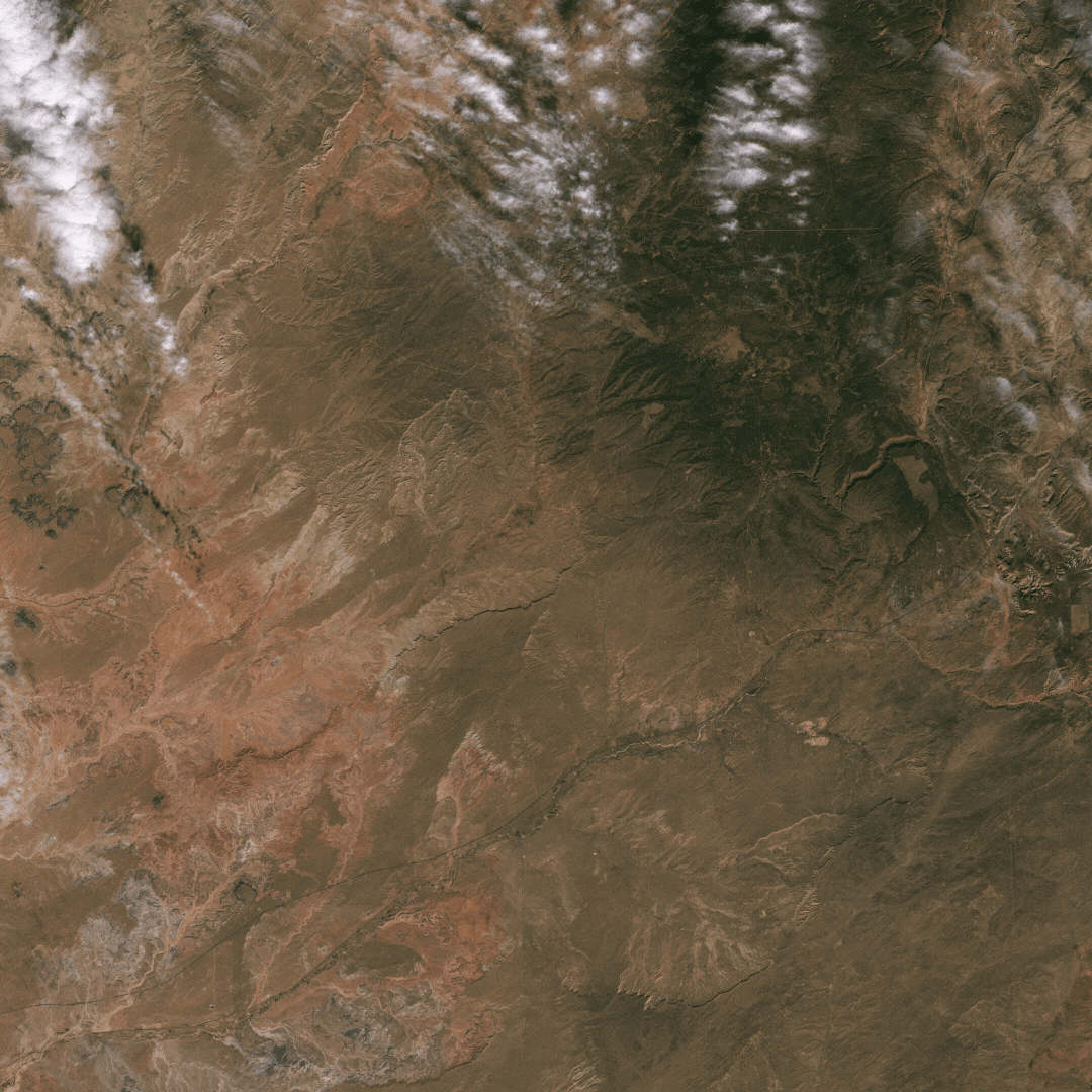
Landsat 9 image of the SANSA Ground Station
Landsat 9 image of the South African National Space Agency's (SANSA) Hartebeesthoek ground station in Pretoria, South Africa. Part of the The USGS Landsat International Cooperator Network, the ground station celebrated its 50th anniversary in 2022.
Landsat 9 image of the South African National Space Agency's (SANSA) Hartebeesthoek ground station in Pretoria, South Africa. Part of the The USGS Landsat International Cooperator Network, the ground station celebrated its 50th anniversary in 2022.

Landsat 9 Image of Ramas Bridge
This Landsat 9 image displays Rama's Bridge (also known as Rama Setu, or Adam's Bridge), a 48 kilometer chain of limestone shoals & sand bars between Pamban Island, off the south-eastern coast of India, and Mannar Island, off the north-western coast of Sri Lanka.
This Landsat 9 image displays Rama's Bridge (also known as Rama Setu, or Adam's Bridge), a 48 kilometer chain of limestone shoals & sand bars between Pamban Island, off the south-eastern coast of India, and Mannar Island, off the north-western coast of Sri Lanka.