
Salt deposits along the Paria River, UT. USGS scientists are studying salinity in the Upper Colorado Basin.
Images
Explore water-related photography, imagery, and illustrations.
Filter Total Items: 2553

Salt deposits along the Paria River, UT
Salt deposits along the Paria River, UT. USGS scientists are studying salinity in the Upper Colorado Basin.

Dolores River, CO
The Dolores River, CO, a tributary of the Colorado River. USGS scientists are studying salinity in the Upper Colorado Basin.
The Dolores River, CO, a tributary of the Colorado River. USGS scientists are studying salinity in the Upper Colorado Basin.

HIVIS camera along the San Antonio River
A Hydrologic Imagery Visualization and Information System (HIVIS) camera along the San Antonio River in San Antonio, Texas. The camera is used to verify the position of a gate that is operated by the City of San Antonio. Check out the camera here.
A Hydrologic Imagery Visualization and Information System (HIVIS) camera along the San Antonio River in San Antonio, Texas. The camera is used to verify the position of a gate that is operated by the City of San Antonio. Check out the camera here.

Tarah Balden, scientist, Yurok Tribe looking at data logger
Tarah Balden, scientist, Yurok Tribe looking at data loggerA soil moisture data logger buried in the ground is a specialized instrument designed to measure and record the moisture content of soil over time. Here's how it generally functions:
Logo for Pywatershed
The image is the logo for pywatershed created by James L. Mccreight. jmccreight@usgs.gov
The image is the logo for pywatershed created by James L. Mccreight. jmccreight@usgs.gov

Makamaka'ole_Stream_Maui_portrait.JPG
Photo of a lush green forested area around Makamaka‘ole Stream near Kānoa Ridge, Maui.
Photo of a lush green forested area around Makamaka‘ole Stream near Kānoa Ridge, Maui.

Makamaka'ole_Stream_Maui_landscape.JPG
Photo of lush green forested area around Makamaka‘ole Stream near Kānoa Ridge, Maui.
Photo of lush green forested area around Makamaka‘ole Stream near Kānoa Ridge, Maui.

Nakula_cloud_forest_Maui.JPG
Cloud covered forest landscape in Nakula, Maui with outlines of trees in the distance.
Cloud covered forest landscape in Nakula, Maui with outlines of trees in the distance.

Le cycle de l’eau - The Water Cycle, French (Canadian) (PNG)
Le cycle de l’eau - The Water Cycle, French (Canadian) (PNG)*English is the official language and authoritative version of all federal information
Le cycle de l’eau - The Water Cycle, French (Canadian) (PNG)
Le cycle de l’eau - The Water Cycle, French (Canadian) (PNG)*English is the official language and authoritative version of all federal information

Su döngüsü - The Water Cycle, Turkish (PNG)
This diagram, released in English and Spanish in 2022, depicts the global water cycle. It shows how human water use affects where water is stored, how it moves, and how clean it is. This diagram is also available in other languages available on our Downloadable Products page.
This diagram, released in English and Spanish in 2022, depicts the global water cycle. It shows how human water use affects where water is stored, how it moves, and how clean it is. This diagram is also available in other languages available on our Downloadable Products page.

USGS HABs Cooperarative Matching Funds Projects
The USGS National Water Quality Program (NWQP) is funding 24 projects in 15 geographic areas that advance real-time monitoring, remote sensing, and use of molecular techniques in identifying and predicting the occurrence of HABs and the toxins they produce.
The USGS National Water Quality Program (NWQP) is funding 24 projects in 15 geographic areas that advance real-time monitoring, remote sensing, and use of molecular techniques in identifying and predicting the occurrence of HABs and the toxins they produce.

Upper Colorado River Basin streamflow, March-August 2023
Upper Colorado River Basin streamflow, March-August 2023March-August daily average streamflow for the last 30 years (1991-2022) (dark gray lines) compared to 2023, showing the periods where 2023 streamflow was above (blue) and below (orange) the historical average. Individual years of the relevant historical streamflow period are shown in light gray.

Integrated Water Science: Willamette River Basin, Oregon
Integrated Water Science: Willamette River Basin, OregonMap of the Integrated Water Science study area for the Willamette River Basin, Oregon.
Integrated Water Science: Willamette River Basin, Oregon
Integrated Water Science: Willamette River Basin, OregonMap of the Integrated Water Science study area for the Willamette River Basin, Oregon.
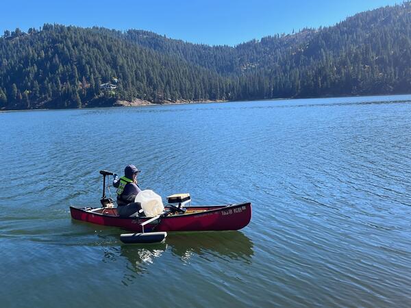
Field sampling by boat in Lake Fernan, Idaho
Collecting field samples to validate satellite remote sensing of water quality on Fernan Lake, Idaho.
Collecting field samples to validate satellite remote sensing of water quality on Fernan Lake, Idaho.

USGS Michigan Bacteriological Research Laboratory
Photo of the USGS UMID Michigan Bacteriological Research Laboratory at the Upper Midwest Water Science Center
Photo of the USGS UMID Michigan Bacteriological Research Laboratory at the Upper Midwest Water Science Center
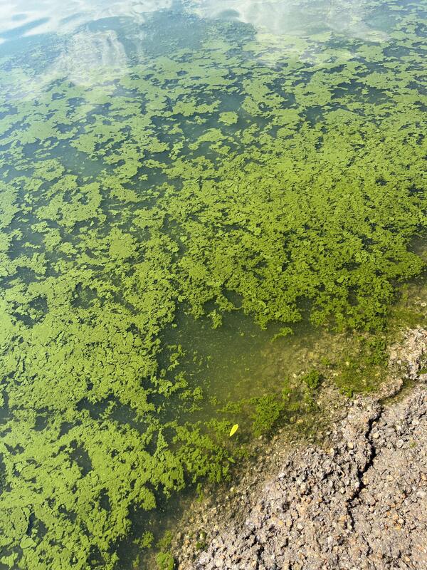
Cyanobacteria algae near the shore of Lake Lowell, Idaho
Cyanobacteria algae near the shore of Lake Lowell, IdahoCyanobacteria (a form of algae) accumulated near the shore of Lake Lowell, Idaho. Field samples from this site visit are used to validate satellite remote sensing of water quality.
Cyanobacteria algae near the shore of Lake Lowell, Idaho
Cyanobacteria algae near the shore of Lake Lowell, IdahoCyanobacteria (a form of algae) accumulated near the shore of Lake Lowell, Idaho. Field samples from this site visit are used to validate satellite remote sensing of water quality.
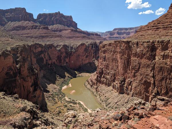
Grand_Canyon_20230908_Brennan.jpg
Photograph of the Colorado River in the Grand Canyon, Arizona, USA. Photo taken on September 8, 2023.
By
Core Science Systems Mission Area, Natural Hazards Mission Area, Water Resources Mission Area, Mineral Resources Program, National Cooperative Geologic Mapping Program, National Water Quality Program, Toxic Substances Hydrology, Geology, Geophysics, and Geochemistry Science Center, Geology, Minerals, Energy, and Geophysics Science Center, Geosciences and Environmental Change Science Center, New Mexico Water Science Center, Southwest Biological Science Center, Denver Radiogenic Isotope Lab, National Water Quality Laboratory, New Mexico Water Science Center Sediment Laboratory, Organic Geochemistry Laboratory, Geological Materials Repository, Geology and Ecology of National Parks, Colorado River Basin: Actionable and Strategic Integrated Science and Technology
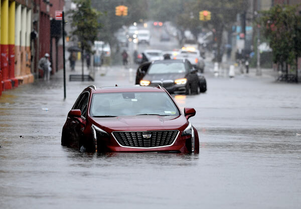
Abandoned cars on a flooded street in Brooklyn, NY.
Abandoned cars on a flooded street in Brooklyn, NY.Abandoned cars on a flooded street in the Gowanus neighborhood of Brooklyn, NY during a storm in 2023.
Abandoned cars on a flooded street in Brooklyn, NY.
Abandoned cars on a flooded street in Brooklyn, NY.Abandoned cars on a flooded street in the Gowanus neighborhood of Brooklyn, NY during a storm in 2023.
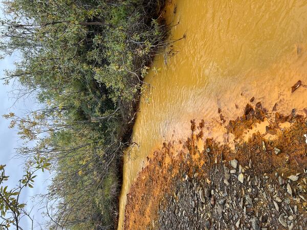
An orange tributary of the Kugururok River, Noatak National Preserve, Alaska
An orange tributary of the Kugururok River, Noatak National Preserve, AlaskaOrange streams are increasingly common in the Brooks Range of northern Alaska. The orange stream color reflects oxidized iron, but also often indicates elevated heavy metal concentrations. Our ongoing study aims to document these occurrences and the timing of their onset.

MuddyCreekChannel.jpg
Vegetation growth is assisting the Muddy Creek channel in becoming deeper and narrower (Carbon County, Wyoming). Photo by Patrick Anderson (USGS)
Vegetation growth is assisting the Muddy Creek channel in becoming deeper and narrower (Carbon County, Wyoming). Photo by Patrick Anderson (USGS)

Rising glacial lake in Alaska
This is a screenshot taken from a timelapse video of a rising glacial lake from May through August 2023. The video was captured by a USGS Hydrologic Imagery Visualization and Information System (HIVIS) camera. The water level in the lake gradually rises throughout the video and then the water level dramatically decreases towards the end of the video.
This is a screenshot taken from a timelapse video of a rising glacial lake from May through August 2023. The video was captured by a USGS Hydrologic Imagery Visualization and Information System (HIVIS) camera. The water level in the lake gradually rises throughout the video and then the water level dramatically decreases towards the end of the video.