
Cryosphere: Earth’s Snow, Ice, and Permafrost
Cryosphere: Earth’s Snow, Ice, and Permafrost
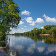
The Arctic and frozen lands are experiencing rapid changes and play large roles in infrastructure, natural resources, and regulation of global climate. The Ecosystems Land Change Science Program conducts research to improve our understanding of avalanches, permafrost, glaciers, and sea ice, and their response to changing climates in the past, present, and future.
Filter Total Items: 18

Glaciers and Landscape Change
Mountain glaciers are dynamic reservoirs of frozen water, deeply interconnected with their surrounding ecosystems. Glacier change in North America has major societal impacts, including to water resources, natural hazard risk, tourism disruption, fisheries, and global sea level change. Understanding and quantifying precise connections between changing glaciers, the surrounding landscape and climate...

Video: Inside the Decades-Long Partnership Keeping Iconic Glacier National Park Road Safe
As the most popular attraction in Glacier National Park, Going-to-the-Sun Road (GTSR) traverses scenic alpine zones and crosses the Continental Divide. The park closes a section of GTSR each winter due to inclement weather, heavy snowfall, and avalanche hazards. Since 2003, efforts to open the road each spring rely on a USGS-National Park Service partnership based on the expertise of USGS...
How Science Helps Manage Changing Water Availability and Quality: Droughts, Floods, Avalanches and More
Droughts, floods, and avalanches are extreme events in the water cycle that can have catastrophic and lasting impacts on ecosystems and society. In addition to these extreme events, human changes to the landscape (including land use changes) can have substantial impacts on freshwater resources as well. Science from the USGS Ecosystems Land Change Science Program helps managers and decision-makers...
By
Ecosystems Land Change Science Program, Alaska Science Center, Earth Resources Observation and Science (EROS) Center, Geosciences and Environmental Change Science Center, New England Water Science Center, Northern Rocky Mountain Science Center, Southwest Biological Science Center, Wetland and Aquatic Research Center
Research Enhancing Park Recreation and Tourism
Scientists from the USGS Ecosystems Land Change Science Program work hand-in-hand with park managers to support abundant and enduring outdoor recreation and tourism opportunities in the Nation’s national parks.
Going-to-the-Sun Road Avalanche Forecasting Program
As the most popular attraction in Glacier National Park, Going-to-the-Sun Road (GTSR) traverses scenic alpine zones and crosses the Continental Divide. The Park closes a section of GTSR each winter due to inclement weather, heavy snowfall, and avalanche hazards. Annual spring opening of GTSR is a highly anticipated event for visitors, and the regional economy is strongly tied to the road’s...

Did we start the fire? Drought, Fire and Humans
The past decade encompasses some of the most extensive fire activity in recorded history. An area the size of Vermont (~24,000 km2) burned in a single Siberian fire in the summer of 2019 (Kehrwald et al., 2020 and references therein) while Australia, Indonesia and the Amazon have all experienced their most intense fires in recorded history (van Wees et al, 2021 and references therein). As more...

Wet Snow Avalanche Research
Wet snow avalanches, including both wet slab and glide avalanches, are dangerous and can be particularly difficult to predict because they are relatively poorly understood compared to dry snow avalanches. They pose significant risk to human life and infrastructure in mountainous areas throughout the world. Wet snow avalanches are caused by weakening in the strength of the snowpack, often triggered...

Remote Sensing Tools Advance Avalanche Research
The USGS Snow and Avalanche Project (SNAP) uses remotely sensed technologies to understand snowpack changes that influence water storage, recreation, avalanche hazard and acts as a driver of landscape change. Satellites, uninhabited aerial systems (UAS), and structure-from-motion (SfM) photogrammetry are some of the tools scientists use to collect high resolution imagery that supports ongoing snow...

Arctic Biogeochemical Response to Permafrost Thaw (ABRUPT)
Warming and thawing of permafrost soils in the Arctic is expected to become widespread over the coming decades. Permafrost thaw changes ecosystem structure and function, affects resource availability for wildlife and society, and decreases ground stability which affects human infrastructure. Since permafrost soils contain about half of the global soil carbon (C) pool, the magnitude of C losses...
USGS Snow and Avalanche Project
Snow avalanches are a widespread natural hazard to humans and infrastructure as well as an important landscape disturbance affecting mountain ecosystems. Forecasting avalanche frequency is challenging on various spatial and temporal scales, and this project aims to fill a gap in snow science by focusing on reconstructing avalanche history on the continental mountain range scale - throughout the...

Past Perspectives of Water in the West
In the intermountain west, seasonal precipitation extremes, combined with population growth, are creating new challenges for the management of water resources, ecosystems, and geologic hazards. This research contributes a comprehensive long-term context for a deeper understanding of past hydrologic variability, including the magnitude and frequency of drought and flood extremes and ecosystem...

Wetlands in the Quaternary
Wetlands accumulate organic-rich sediment or peat stratigraphically, making them great archives of past environmental change. Wetlands also act as hydrologic buffers on the landscape and are important to global biogeochemical cycling. This project uses wetland archives from a range of environments to better understand how vegetation, hydrology, and hydroclimate has changed on decadal to multi...