
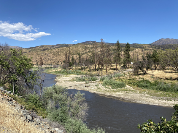
The photo shows the Klamath River following the 2022 McKinney Fire, with burned areas visible along the distant ridgeline and a debris fan in the foreground near the confluence of Little Humbug Creek and the Klamath River. The photo documents sediment and debris deposited from burned landscapes into the river corridor following wildfire and storm runoff.
Images
Images described and linked on this webpage come from a wide variety of USGS science activities and presentations performed by USGS Science Center staff members in the Region 10: California-Great Basin. A search tool is provided to narrow the number of image files shown.
Filter Total Items: 115
Post-Fire Landscape
The photo shows the Klamath River following the 2022 McKinney Fire, with burned areas visible along the distant ridgeline and a debris fan in the foreground near the confluence of Little Humbug Creek and the Klamath River. The photo documents sediment and debris deposited from burned landscapes into the river corridor following wildfire and storm runoff.

Mendenhall Fellows Sabine Loos and Max Schneider
In June 2022, Mendenhall Fellow Sabine Loos (Research Civil Engineer in the Geological Hazards Science Center) presented a seminar to USGS's Earthquake Science Center at Moffett Field, CA, where Max Schneider (Research Statistician) works as a Mendenhall Fellow.
In June 2022, Mendenhall Fellow Sabine Loos (Research Civil Engineer in the Geological Hazards Science Center) presented a seminar to USGS's Earthquake Science Center at Moffett Field, CA, where Max Schneider (Research Statistician) works as a Mendenhall Fellow.

Partners in Science trip participants cool down under a small waterfall on a hot day
Partners in Science trip participants cool down under a small waterfall on a hot dayGrand Canyon Youth/Partners in Science trip participants cool down under a small waterfall on a hot day
Partners in Science trip participants cool down under a small waterfall on a hot day
Partners in Science trip participants cool down under a small waterfall on a hot dayGrand Canyon Youth/Partners in Science trip participants cool down under a small waterfall on a hot day

Drought Intensity Map, April 19, 2022
Drought Intensity Map compiled by the U.S. Drought Monitor for the area of NOAA's Colorado River Basin River Forecast Center, which includes part of the Great Basin drainage area in western Utah, for April 19, 2024.
Drought Intensity Map compiled by the U.S. Drought Monitor for the area of NOAA's Colorado River Basin River Forecast Center, which includes part of the Great Basin drainage area in western Utah, for April 19, 2024.

Airborne Geophysical Survey Helicopter with Cow
A helicopter rigged with an airborne geophysical survey collecting equipment. Information collected during these surveys can help with studying critical mineral resources, natural hazards and groundwater potential. A cow is here too.
A helicopter rigged with an airborne geophysical survey collecting equipment. Information collected during these surveys can help with studying critical mineral resources, natural hazards and groundwater potential. A cow is here too.

Airborne Geophysical Survey Helicopter in Nevada
A low-flying helicopter towing a geophysical device collects scientific data on groundwater and geology. Information collected during these surveys can help with studying critical mineral resources, natural hazards and groundwater potential.
A low-flying helicopter towing a geophysical device collects scientific data on groundwater and geology. Information collected during these surveys can help with studying critical mineral resources, natural hazards and groundwater potential.

RestoreNet restoration teatments in the Sonoran Desert
RestoreNet restoration teatments in the Sonoran DesertRestoreNet treatments include soil pits and connectivity modifiers (ConMods), seen here at a RestoreNet site in the Sonoran Desert.
RestoreNet restoration teatments in the Sonoran Desert
RestoreNet restoration teatments in the Sonoran DesertRestoreNet treatments include soil pits and connectivity modifiers (ConMods), seen here at a RestoreNet site in the Sonoran Desert.

Ruby Lake National Wildlife Reserve
Ruby Lake National Wildlife Refuge lies at the southern end of Ruby Valley in northeast Nevada. For more information visit the Ruby Lake NWR website.
By
Ecosystems Mission Area, Water Resources Mission Area, Land Management Research Program, Water Availability and Use Science Program, Climate Adaptation Science Centers, Forest and Rangeland Ecosystem Science Center, Fort Collins Science Center, Nevada Water Science Center, Oregon Water Science Center, Utah Water Science Center, Western Ecological Research Center (WERC), Saline Lakes Ecosystems Integrated Water Availability Assessment

Autonomous Augmentation System Test Platform – Sandy the rover with BisonCore installed
Autonomous Augmentation System Test Platform – Sandy the rover with BisonCore installedUAS Research Center's BisonCore Project, Autonomous Rover Sandy is equipped with a single board companion computer (with BisonCore installed), and various sensors useful for augmentation testing and development.

Joanne Chan - Seismic Survey
Joanne Chan conducting a seismic survey in San Carlos, California, looking for traces of the Serra Fault.
Joanne Chan conducting a seismic survey in San Carlos, California, looking for traces of the Serra Fault.
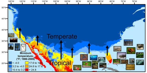
U.S. regions in the tropical-to-temperate transition
U.S. regions in the tropical-to-temperate transitionA map showing North America's tropical-to-temperate transition zone. Red, orange, and yellow depict the more tropical zones, and blues depict the more temperate zones, based on to the coldest recorded temperature for each area between 1980 and 2009.

BisonCore’s Collision Detection Avoidance Algorithms safely keep the vehicle from running into obstacles
BisonCore’s Collision Detection Avoidance Algorithms safely keep the vehicle from running into obstaclesUAS Research Center's BisonCore Project, augments an autonomous rover to avoid running into obstacles. Shown in picture; user set waypoint (2) that runs over a curb/barrier. CDA engaged and navigated south avoiding, and seeking a path around, the curb.
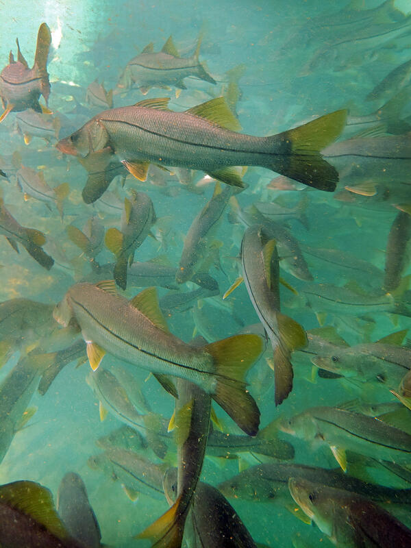
Subtropical snook gather at a warm Florida springhead in winter
Subtropical snook gather at a warm Florida springhead in winterWinter temperature extremes control the distributions of subtropical fishes. Common snook (Centropomus undecimalis), aggregate at a spring in northern Florida during winter. Snook are warm saltwater game fish, common in Florida, that have been moving further northward as extreme cold spells become less frequent and less intense.

Burned, denuded hillside in the CZU Lightning Complex
Burned, denuded hillside in the CZU Lightning ComplexThe USGS landslide team monitors and continues to update the hazard map models based on data collected in burn areas. This information improves future models and provides better hazard assessments used by officials for emergency response and decision making. Many of the steep hillsides burned and denuded in California fires repel water rather than soak it in.

EnviSense with stage sensor at USGS streamgage at Beale Air Force Base near Marysville CA
EnviSense with stage sensor at USGS streamgage at Beale Air Force Base near Marysville CAEnviSense data-logger/transmitter developed by Carnegie Mellon University actively deployed with stage sensor at USGS streamgage at Beale Air Force Base near Marysville, California.

Adult Lahontan cutthroat trout
Lahontan cutthroat trout (Oncorhynchus clarkii henshawi) is a federally listed threatened species. Ninety-seven percent of their range are small headwater streams in the Great Basin of North America.
Lahontan cutthroat trout (Oncorhynchus clarkii henshawi) is a federally listed threatened species. Ninety-seven percent of their range are small headwater streams in the Great Basin of North America.
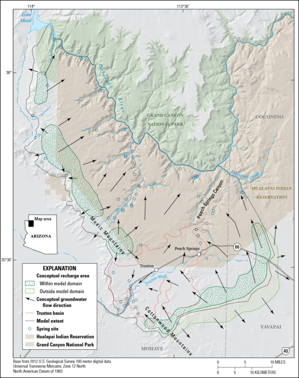
Image showing a conceptual model of the Truxton Basin and Hualapai Plateau groundwater-flow system in northwestern Arizona
Image showing a conceptual model of the Truxton Basin and Hualapai Plateau groundwater-flow system in northwestern ArizonaThis report includes five chapters. Chapter A (Mason, Knight, and others, 2020) is a summary of this multichapter volume and briefly describes the study area. Chapter B (Mason, Bills, and Macy, 2020) describes the geology and hydrology of the Truxton basin and Hualapai Plateau.

BisonCore project equipment identifying marker
USGS National Innovation Center's UAS Research Center BisonCore Project Equipment Identifying Marker
USGS National Innovation Center's UAS Research Center BisonCore Project Equipment Identifying Marker

Wind turbines in California
Wind turbines at the San Gorgonio Pass Wind Resource Area north of Palm Springs in California.
Wind turbines at the San Gorgonio Pass Wind Resource Area north of Palm Springs in California.

Dragonfly Mercury Project specimen collection in Glacier NP
Dragonfly Mercury Project specimen collection in Glacier NPResearchers instruct volunteers on how to collect dragonfly larvae in Glacier NP as a part of the Dragonfly Mercury Project.
Dragonfly Mercury Project specimen collection in Glacier NP
Dragonfly Mercury Project specimen collection in Glacier NPResearchers instruct volunteers on how to collect dragonfly larvae in Glacier NP as a part of the Dragonfly Mercury Project.

Home damaged by post-wildfire debris flow in Montecito, CA.
Home damaged by post-wildfire debris flow in Montecito, CA.Damage from a major post-wildfire landslide that occurred on 9 January 2018 near Montecito, Santa Barbara County as a result of the 2017 Thomas Fire.
Home damaged by post-wildfire debris flow in Montecito, CA.
Home damaged by post-wildfire debris flow in Montecito, CA.Damage from a major post-wildfire landslide that occurred on 9 January 2018 near Montecito, Santa Barbara County as a result of the 2017 Thomas Fire.