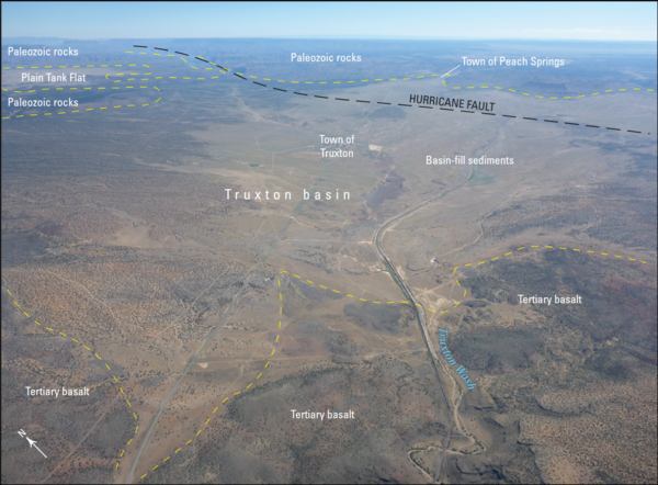
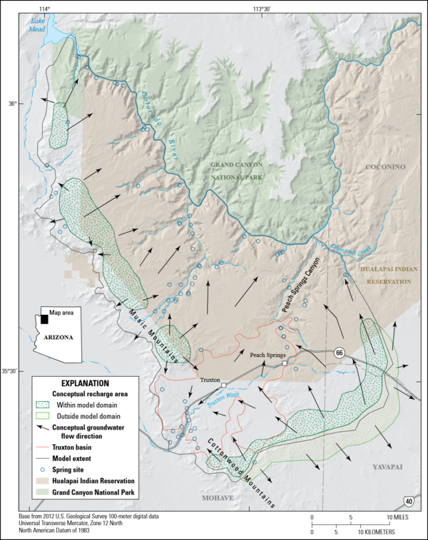
Scientists collect carcasses at a wind energy facility to estimate total wildlife mortality at a site.
Images
Images described and linked on this webpage come from a wide variety of USGS science activities and presentations performed by USGS Science Center staff members in the Region 10: California-Great Basin. A search tool is provided to narrow the number of image files shown.
Scientists collect carcasses at a wind energy facility to estimate total wildlife mortality at a site.
Burned, hollowed out base of a sequoia tree in Sequoia National Park
Burned, hollowed out base of a sequoia tree in Sequoia National ParkBurned, hollowed out base of a sequoia tree in Sequoia National Park
Burned, hollowed out base of a sequoia tree in Sequoia National Park
Burned, hollowed out base of a sequoia tree in Sequoia National ParkBurned, hollowed out base of a sequoia tree in Sequoia National Park
RestoreNet outplanted seedlings (left) v. direct seeding with soil surface treatments (right)
RestoreNet outplanted seedlings (left) v. direct seeding with soil surface treatments (right)Left: RestoreNet outplant trials with greenhouse-grown seedlings planted into the field, Right: RestoreNet direct seeding trials with seeds combined with soil surface modifications including ConMod artificial nurse plants, mulch, and soil pits. Photos by Katie Laushman (USGS).
Montecito home damaged by post-wildfire debrisflow.
Montecito home damaged by post-wildfire debrisflow.Damage from a major post-wildfire landslide that occurred on 9 January 2018 near Montecito, Santa Barbara County as a result of the 2017 Thomas Fire.
Montecito home damaged by post-wildfire debrisflow.
Montecito home damaged by post-wildfire debrisflow.Damage from a major post-wildfire landslide that occurred on 9 January 2018 near Montecito, Santa Barbara County as a result of the 2017 Thomas Fire.
Photograph of Freeport McMoRan-Safford Copper Mine in Arizona. Photograph taken by Thomas J. Porter (USGS) on September 19, 2016, Latitude 32.85992 deg N, Longitude -109.622
Christie Hegermiller geared up for beach elevation survey
Christie Hegermiller geared up for beach elevation surveyChristie gears up to survey beach elevation in Santa Cruz, CA with a precise and accurate GPS unit mounted to her backpack. The GPS unit on her backpack communicates with a nearby "base station" to minimize errors in location.
Aerial photograph of the Truxton Basin, northwestern Arizona, showing boundaries and geologic features
Aerial photograph of the Truxton Basin, northwestern Arizona, showing boundaries and geologic featuresAerial photograph of the Truxton basin, Arizona (view to northeast). Yellow dashed lines are approximate boundaries between labeled geologic features and units. From figure 2 in chapter B of Mason 2020
USGS photo of Ray Copper Mine in Pinal County, Arizona. Taken by Mark Coker on September 1, 2007. Revised for brightness and contrast for use as a webpage Carousel image.