
Marine Geohazards
Volcano Eruption- Hunga Tonga-Hunga Ha‘apai, Tonga
2022
Submarine Landslide- Resurrection Bay, Alaska
1964
Tsunami Damage- Natori, Japan
2011
Earthquake Damage- Fourth Avenue, Anchorage, Alaska
1964
Deepwater Horizon Oil Spill, Gulf of Mexico
2016
Viscous Lava- Kīlauea, Hawai‘i
2018
Geologic activity in the ocean can cause dangerous or catastrophic events that threaten lives and critical infrastructure both at sea and on land. The USGS studies these geological events beneath the sea floor, known as marine geohazards, to provide decision makers with the information needed to mitigate risks to human communities, infrastructure, and the environment.
What are marine geohazards?
Marine geohazards, or ‘dangers in the deep’ include earthquakes, volcanic eruptions, submarine landslides, and tsunamis, as well as dissociation of gas hydrates—which can cause seafloor collapse—and oil spills or toxic seeps that affect deep sea life or change the physical characteristics of ocean environments.


Science to Address Hazards
Earthquakes, Landslides, and Tsunamis

Underwater earthquakes and landslides can generate tsunamis that cause hazards for coastal communities. USGS scientists study the subduction zone and the recent history of marine hazards and evaluate the future potential and probable impacts of such events on a regional basis. Quantifying these various hazards (e.g., earthquakes, landslides, tsunamis, and volcanoes) using geological and geophysical data, interpretations, and models improves understanding of the underlying processes of marine geohazards to assess the threats they pose. The USGS develops reliable deterministic and probabilistic estimates of the hazards that are used by engineers and policymakers to help reduce risk.
One barrier to measuring seismic risk has been the scarcity of high-resolution maps of the ocean floor. To fill these gaps, USGS scientists conduct high-resolution mapping offshore, especially near urban regions such as Southern California and the Pacific Northwest that are particularly at risk from seismic hazards. Creating three-dimensional views of the seafloor has given scientists remarkable ways to examine how a fault works, or how fluids may follow underground paths and potentially trigger submarine landslides. These landslides threaten offshore structures such as seafloor pipelines, cables, and equipment for oil and gas exploration. They can also trigger tsunamis that endanger coastal communities worldwide.
To discover a fault’s structure, scientists go to sea to collect streams of data that they turn into comprehensive underwater maps. This type of imaging, along with knowing the age of the sediment along faults and measuring other factors such as magnetics and density, can help tell the story of when the fault last ruptured or how fast it is moving. USGS incorporates these data, which have historically been challenging to collect, into earthquake models to estimate their actual hazard risk. Using high-resolution mapping and seismic technology to gather detailed seafloor data can directly impact human life and cities by improving earthquake and tsunami forecasts.
Research results are used in evaluations of earthquake risk zoning, public disaster education and preparedness, and engineering and building codes. Additionally, reassessing the threat of earthquake, tsunami, and landslide hazards to ports and nuclear power plants can directly impact facility management, emergency-management planning, and plant re-licensing.
The Atlantic and Gulf of Mexico margins are heavily urbanized, support extensive port and industrial/resource facilities, and host 10 nuclear power plants. The USGS completed quantitative assessments of submarine landslides for the U.S. Atlantic coast from Maine to Florida and throughout the Gulf of Mexico to better comprehend the risk of potential submarine landslides and tsunamis to these areas and associated infrastructure.


Gas Hydrates and Seafloor Collapse

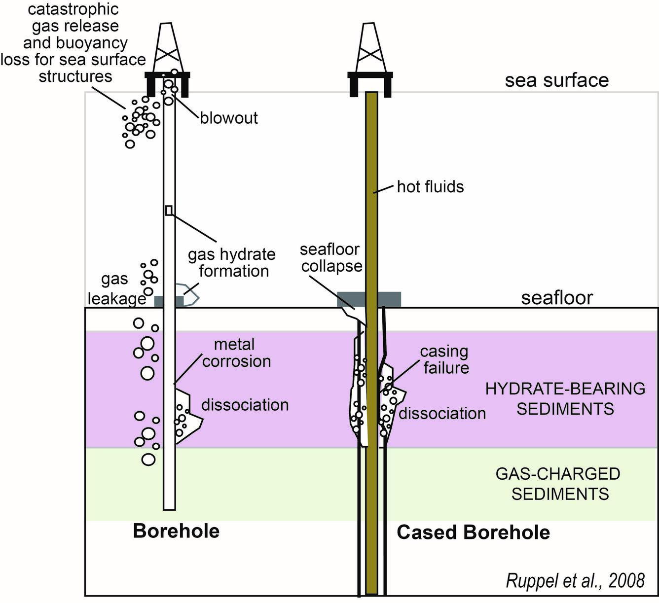
Naturally occurring gas hydrates are ice-like combinations of water and (usually methane) gas that form in sediment below the sea floor and in areas of continuous permafrost when pressure and temperature conditions are appropriate.
In deep water marine settings where warm fluids are pumped from great depths below the seafloor for extraction of conventional oil and gas, heating of sediments near a well could lead to breakdown of gas hydrates and release gas and water. Intact gas hydrates generally strengthen marine sediments, and dissociation of gas hydrates could lead to subsidence or collapse of the seafloor near the well. Features associated with natural failure of the seafloor (landslides) have also been linked to gas hydrates in some cases. USGS scientists support submarine geohazards research through field-based surveys that refine understanding of the hydrates-slope failure association and through geotechnical studies that evaluate the response of sediments to dissociation or dissolution of gas hydrates.
Science

Cascadia Subduction Zone Marine Geohazards

California Seafloor Mapping Program

Seafloor Faults off Southern California

Hazards: EXPRESS

Coastal and Marine Geohazards of the U.S. West Coast and Alaska
Multimedia


Science crew from the USGS Pacific Coastal and Marine Science Center work on deployment of seismic streamer on deck of R/V Robert Gordon Sproul. Green cable is the hydrophone streamer and a "bird" is being attached to control depth in the water.
Science crew from the USGS Pacific Coastal and Marine Science Center work on deployment of seismic streamer on deck of R/V Robert Gordon Sproul. Green cable is the hydrophone streamer and a "bird" is being attached to control depth in the water.

Looking across the back deck/stern of the R/V Robert Gordon Sproul. The wire going through the block in the A-frame leads to the CHIRP sonar fish towed in the water. Oil platforms are shown in the distance.
Looking across the back deck/stern of the R/V Robert Gordon Sproul. The wire going through the block in the A-frame leads to the CHIRP sonar fish towed in the water. Oil platforms are shown in the distance.

On December 26th, 2004, a massive 9.1 magnitude earthquake struck off the west coast of northern Sumatra, Indonesia. The third largest earthquake ever recorded lifted the sea floor several meters, causing tsunami waves to ripple out in all directions and race across the ocean. Banda Aceh bore the brunt of the waves just 15 to 20 minutes after the earthquake.
On December 26th, 2004, a massive 9.1 magnitude earthquake struck off the west coast of northern Sumatra, Indonesia. The third largest earthquake ever recorded lifted the sea floor several meters, causing tsunami waves to ripple out in all directions and race across the ocean. Banda Aceh bore the brunt of the waves just 15 to 20 minutes after the earthquake.

Dr. Nora Nieminski is a research geologist and Mendenhall Fellow at the USGS Pacific Coastal and Marine Science Center in Santa Cruz, California. She is pictured here, on board Marine Vessel Bold Horizon, with a piston core sample collected from the southern Cascadia subduction zone offshore of northern California/southern Oregon.
Dr. Nora Nieminski is a research geologist and Mendenhall Fellow at the USGS Pacific Coastal and Marine Science Center in Santa Cruz, California. She is pictured here, on board Marine Vessel Bold Horizon, with a piston core sample collected from the southern Cascadia subduction zone offshore of northern California/southern Oregon.

Jumbo piston corer

Multichannel seismic-reflection profile across the Queen Charlotte-Fairweather fault, acquired aboard the R/V Norseman in August 2016. Dashed red line in enlarged section at lower right is the Queen Charlotte-Fairweather fault. m, meter; km, kilometer; ms, millisecond.
Multichannel seismic-reflection profile across the Queen Charlotte-Fairweather fault, acquired aboard the R/V Norseman in August 2016. Dashed red line in enlarged section at lower right is the Queen Charlotte-Fairweather fault. m, meter; km, kilometer; ms, millisecond.

Dan Ebuna (University of California, Santa Cruz; left) and Jackson Currie (USGS) work on the R/V Norseman amid thick fog on Resurrection Bay. They are preparing to test equipment that will image sediment layers beneath the seafloor.
Dan Ebuna (University of California, Santa Cruz; left) and Jackson Currie (USGS) work on the R/V Norseman amid thick fog on Resurrection Bay. They are preparing to test equipment that will image sediment layers beneath the seafloor.

Mary McGann (left, USGS) and Rachel Lauer (University of Calgary) sample pore fluids from sediment cores collected aboard the Canadian Coast Guard Ship John P.
Mary McGann (left, USGS) and Rachel Lauer (University of Calgary) sample pore fluids from sediment cores collected aboard the Canadian Coast Guard Ship John P.

Improved earthquake and tsunami monitoring in the Caribbean. The map shows the seismicity and tectonic setting of the region as well as planned USGS and NOAA monitoring stations. The planned seismic stations will be affiliated with the Global Seismographic Network (GSN), which is funded jointly by the National Science Foundation and the USGS.
Improved earthquake and tsunami monitoring in the Caribbean. The map shows the seismicity and tectonic setting of the region as well as planned USGS and NOAA monitoring stations. The planned seismic stations will be affiliated with the Global Seismographic Network (GSN), which is funded jointly by the National Science Foundation and the USGS.

Marine technicians from the USGS Pacific Coastal and Marine Science Center Marine Facility (MarFac) guide the jumbo piston corer into position for deployment off the ship.
Marine technicians from the USGS Pacific Coastal and Marine Science Center Marine Facility (MarFac) guide the jumbo piston corer into position for deployment off the ship.
Geologic activity in the ocean can cause dangerous or catastrophic events that threaten lives and critical infrastructure both at sea and on land. The USGS studies these geological events beneath the sea floor, known as marine geohazards, to provide decision makers with the information needed to mitigate risks to human communities, infrastructure, and the environment.
What are marine geohazards?
Marine geohazards, or ‘dangers in the deep’ include earthquakes, volcanic eruptions, submarine landslides, and tsunamis, as well as dissociation of gas hydrates—which can cause seafloor collapse—and oil spills or toxic seeps that affect deep sea life or change the physical characteristics of ocean environments.
Science to Address Hazards
Earthquakes, Landslides, and Tsunamis
Underwater earthquakes and landslides can generate tsunamis that cause hazards for coastal communities. USGS scientists study the subduction zone and the recent history of marine hazards and evaluate the future potential and probable impacts of such events on a regional basis. Quantifying these various hazards (e.g., earthquakes, landslides, tsunamis, and volcanoes) using geological and geophysical data, interpretations, and models improves understanding of the underlying processes of marine geohazards to assess the threats they pose. The USGS develops reliable deterministic and probabilistic estimates of the hazards that are used by engineers and policymakers to help reduce risk.
One barrier to measuring seismic risk has been the scarcity of high-resolution maps of the ocean floor. To fill these gaps, USGS scientists conduct high-resolution mapping offshore, especially near urban regions such as Southern California and the Pacific Northwest that are particularly at risk from seismic hazards. Creating three-dimensional views of the seafloor has given scientists remarkable ways to examine how a fault works, or how fluids may follow underground paths and potentially trigger submarine landslides. These landslides threaten offshore structures such as seafloor pipelines, cables, and equipment for oil and gas exploration. They can also trigger tsunamis that endanger coastal communities worldwide.
To discover a fault’s structure, scientists go to sea to collect streams of data that they turn into comprehensive underwater maps. This type of imaging, along with knowing the age of the sediment along faults and measuring other factors such as magnetics and density, can help tell the story of when the fault last ruptured or how fast it is moving. USGS incorporates these data, which have historically been challenging to collect, into earthquake models to estimate their actual hazard risk. Using high-resolution mapping and seismic technology to gather detailed seafloor data can directly impact human life and cities by improving earthquake and tsunami forecasts.
Research results are used in evaluations of earthquake risk zoning, public disaster education and preparedness, and engineering and building codes. Additionally, reassessing the threat of earthquake, tsunami, and landslide hazards to ports and nuclear power plants can directly impact facility management, emergency-management planning, and plant re-licensing.
The Atlantic and Gulf of Mexico margins are heavily urbanized, support extensive port and industrial/resource facilities, and host 10 nuclear power plants. The USGS completed quantitative assessments of submarine landslides for the U.S. Atlantic coast from Maine to Florida and throughout the Gulf of Mexico to better comprehend the risk of potential submarine landslides and tsunamis to these areas and associated infrastructure.
Gas Hydrates and Seafloor Collapse
Naturally occurring gas hydrates are ice-like combinations of water and (usually methane) gas that form in sediment below the sea floor and in areas of continuous permafrost when pressure and temperature conditions are appropriate.
In deep water marine settings where warm fluids are pumped from great depths below the seafloor for extraction of conventional oil and gas, heating of sediments near a well could lead to breakdown of gas hydrates and release gas and water. Intact gas hydrates generally strengthen marine sediments, and dissociation of gas hydrates could lead to subsidence or collapse of the seafloor near the well. Features associated with natural failure of the seafloor (landslides) have also been linked to gas hydrates in some cases. USGS scientists support submarine geohazards research through field-based surveys that refine understanding of the hydrates-slope failure association and through geotechnical studies that evaluate the response of sediments to dissociation or dissolution of gas hydrates.
Science
Cascadia Subduction Zone Marine Geohazards
California Seafloor Mapping Program
Seafloor Faults off Southern California
Hazards: EXPRESS
Coastal and Marine Geohazards of the U.S. West Coast and Alaska
Multimedia
Science crew from the USGS Pacific Coastal and Marine Science Center work on deployment of seismic streamer on deck of R/V Robert Gordon Sproul. Green cable is the hydrophone streamer and a "bird" is being attached to control depth in the water.
Science crew from the USGS Pacific Coastal and Marine Science Center work on deployment of seismic streamer on deck of R/V Robert Gordon Sproul. Green cable is the hydrophone streamer and a "bird" is being attached to control depth in the water.
Looking across the back deck/stern of the R/V Robert Gordon Sproul. The wire going through the block in the A-frame leads to the CHIRP sonar fish towed in the water. Oil platforms are shown in the distance.
Looking across the back deck/stern of the R/V Robert Gordon Sproul. The wire going through the block in the A-frame leads to the CHIRP sonar fish towed in the water. Oil platforms are shown in the distance.
On December 26th, 2004, a massive 9.1 magnitude earthquake struck off the west coast of northern Sumatra, Indonesia. The third largest earthquake ever recorded lifted the sea floor several meters, causing tsunami waves to ripple out in all directions and race across the ocean. Banda Aceh bore the brunt of the waves just 15 to 20 minutes after the earthquake.
On December 26th, 2004, a massive 9.1 magnitude earthquake struck off the west coast of northern Sumatra, Indonesia. The third largest earthquake ever recorded lifted the sea floor several meters, causing tsunami waves to ripple out in all directions and race across the ocean. Banda Aceh bore the brunt of the waves just 15 to 20 minutes after the earthquake.
Dr. Nora Nieminski is a research geologist and Mendenhall Fellow at the USGS Pacific Coastal and Marine Science Center in Santa Cruz, California. She is pictured here, on board Marine Vessel Bold Horizon, with a piston core sample collected from the southern Cascadia subduction zone offshore of northern California/southern Oregon.
Dr. Nora Nieminski is a research geologist and Mendenhall Fellow at the USGS Pacific Coastal and Marine Science Center in Santa Cruz, California. She is pictured here, on board Marine Vessel Bold Horizon, with a piston core sample collected from the southern Cascadia subduction zone offshore of northern California/southern Oregon.
Jumbo piston corer
Multichannel seismic-reflection profile across the Queen Charlotte-Fairweather fault, acquired aboard the R/V Norseman in August 2016. Dashed red line in enlarged section at lower right is the Queen Charlotte-Fairweather fault. m, meter; km, kilometer; ms, millisecond.
Multichannel seismic-reflection profile across the Queen Charlotte-Fairweather fault, acquired aboard the R/V Norseman in August 2016. Dashed red line in enlarged section at lower right is the Queen Charlotte-Fairweather fault. m, meter; km, kilometer; ms, millisecond.
Dan Ebuna (University of California, Santa Cruz; left) and Jackson Currie (USGS) work on the R/V Norseman amid thick fog on Resurrection Bay. They are preparing to test equipment that will image sediment layers beneath the seafloor.
Dan Ebuna (University of California, Santa Cruz; left) and Jackson Currie (USGS) work on the R/V Norseman amid thick fog on Resurrection Bay. They are preparing to test equipment that will image sediment layers beneath the seafloor.
Mary McGann (left, USGS) and Rachel Lauer (University of Calgary) sample pore fluids from sediment cores collected aboard the Canadian Coast Guard Ship John P.
Mary McGann (left, USGS) and Rachel Lauer (University of Calgary) sample pore fluids from sediment cores collected aboard the Canadian Coast Guard Ship John P.
Improved earthquake and tsunami monitoring in the Caribbean. The map shows the seismicity and tectonic setting of the region as well as planned USGS and NOAA monitoring stations. The planned seismic stations will be affiliated with the Global Seismographic Network (GSN), which is funded jointly by the National Science Foundation and the USGS.
Improved earthquake and tsunami monitoring in the Caribbean. The map shows the seismicity and tectonic setting of the region as well as planned USGS and NOAA monitoring stations. The planned seismic stations will be affiliated with the Global Seismographic Network (GSN), which is funded jointly by the National Science Foundation and the USGS.
Marine technicians from the USGS Pacific Coastal and Marine Science Center Marine Facility (MarFac) guide the jumbo piston corer into position for deployment off the ship.
Marine technicians from the USGS Pacific Coastal and Marine Science Center Marine Facility (MarFac) guide the jumbo piston corer into position for deployment off the ship.