
Zachary H Bowen, Ph.D.
Zachary is currently the Acting Deputy Associate Director for the Ecosystems Mission Area.
Science and Products
Filter Total Items: 17
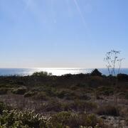
Where Land Meets Sea: USGS Science for Resilient Coastal Habitats
USGS coastal science plays a critical role in supporting the effective, science-based management of coastal ecosystems, where the biodiversity of land and sea meet. It provides managers with the information they need to make sound decisions. Through cutting-edge research, predictive modeling, and decision-support tools, USGS empowers resource managers to make informed, science-based choices. From...
By
Ecosystems Mission Area, Land Management Research Program, California Water Science Center, Eastern Ecological Science Center, Forest and Rangeland Ecosystem Science Center, Lower Mississippi-Gulf Water Science Center, Pacific Coastal and Marine Science Center, Western Ecological Research Center (WERC), Western Fisheries Research Center, Western Geographic Science Center, Wetland and Aquatic Research Center

USGS Sagebrush Science: Supporting Public Safety and Economic Decision Making Across the West
The sagebrush biome is one of the largest ecosystems in North America. Encompassing nearly one-third of the continental U.S., it provides critical resources for millions of Americans and a home for hundreds of plants and animal species in the West. Natural resource management in sagebrush ecosystems can be complex, and science can support management decisions by providing knowledge and tools to...
By
Core Science Systems Mission Area, Ecosystems Mission Area, Biological Threats and Invasive Species Research Program, Climate Adaptation Science Centers, Cooperative Research Units, Land Management Research Program, Species Management Research Program, Earth Resources Observation and Science (EROS) Center , Forest and Rangeland Ecosystem Science Center, Fort Collins Science Center, Northern Rocky Mountain Science Center, Southwest Biological Science Center, Western Ecological Research Center (WERC), Wildland Fire Science

A Matter of Scales: USGS Science to Reduce Invasive Snake Impacts
The U.S. Geological Survey Ecosystem Mission Area plays a major role in invasive snake science across the country and the globe, ranging from research on improving snake detection to projects that enhance eradication. Our extensive science ultimately scales up to benefiting public health, energy transmission, tourism, and other key aspects of American prosperity.

Powering Progress: How Science Can Fuel the Energy Resources Life Cycle
Energy is essential to modern life, and accessing it involves a complex lifecycle, from resource discovery to extraction, use, and eventual remediation and reclamation. The USGS Ecosystems Mission Area supports this process by conducting research and providing scientific insights to guide decision-making at each stage. By collaborating with resource management agencies and stakeholders, we analyze...

USGS Ecosystems Science for Food and Water Security
USGS science developed by the Ecosystems Mission Area helps ensure safe and abundant domestic food and water supplies, ensuring all Americans access to livelihoods and traditions that connect generations with each other and the outdoors and strengthen America’s self-reliance. USGS science is used by decision makers at all levels to understand how the quality of America’s food supply is directly...

USGS Ecosystems Science in Support of Economic Growth
Science provided by the USGS Ecosystems Mission Area helps boost America’s economy by providing practical tools to implement cost-effective management and development strategies that supports the Nation’s economic growth and protects our natural heritage.
Science and Products
Filter Total Items: 17
Where Land Meets Sea: USGS Science for Resilient Coastal Habitats
USGS coastal science plays a critical role in supporting the effective, science-based management of coastal ecosystems, where the biodiversity of land and sea meet. It provides managers with the information they need to make sound decisions. Through cutting-edge research, predictive modeling, and decision-support tools, USGS empowers resource managers to make informed, science-based choices. From...
By
Ecosystems Mission Area, Land Management Research Program, California Water Science Center, Eastern Ecological Science Center, Forest and Rangeland Ecosystem Science Center, Lower Mississippi-Gulf Water Science Center, Pacific Coastal and Marine Science Center, Western Ecological Research Center (WERC), Western Fisheries Research Center, Western Geographic Science Center, Wetland and Aquatic Research Center
USGS Sagebrush Science: Supporting Public Safety and Economic Decision Making Across the West
The sagebrush biome is one of the largest ecosystems in North America. Encompassing nearly one-third of the continental U.S., it provides critical resources for millions of Americans and a home for hundreds of plants and animal species in the West. Natural resource management in sagebrush ecosystems can be complex, and science can support management decisions by providing knowledge and tools to...
By
Core Science Systems Mission Area, Ecosystems Mission Area, Biological Threats and Invasive Species Research Program, Climate Adaptation Science Centers, Cooperative Research Units, Land Management Research Program, Species Management Research Program, Earth Resources Observation and Science (EROS) Center , Forest and Rangeland Ecosystem Science Center, Fort Collins Science Center, Northern Rocky Mountain Science Center, Southwest Biological Science Center, Western Ecological Research Center (WERC), Wildland Fire Science
A Matter of Scales: USGS Science to Reduce Invasive Snake Impacts
The U.S. Geological Survey Ecosystem Mission Area plays a major role in invasive snake science across the country and the globe, ranging from research on improving snake detection to projects that enhance eradication. Our extensive science ultimately scales up to benefiting public health, energy transmission, tourism, and other key aspects of American prosperity.
Powering Progress: How Science Can Fuel the Energy Resources Life Cycle
Energy is essential to modern life, and accessing it involves a complex lifecycle, from resource discovery to extraction, use, and eventual remediation and reclamation. The USGS Ecosystems Mission Area supports this process by conducting research and providing scientific insights to guide decision-making at each stage. By collaborating with resource management agencies and stakeholders, we analyze...
USGS Ecosystems Science for Food and Water Security
USGS science developed by the Ecosystems Mission Area helps ensure safe and abundant domestic food and water supplies, ensuring all Americans access to livelihoods and traditions that connect generations with each other and the outdoors and strengthen America’s self-reliance. USGS science is used by decision makers at all levels to understand how the quality of America’s food supply is directly...
USGS Ecosystems Science in Support of Economic Growth
Science provided by the USGS Ecosystems Mission Area helps boost America’s economy by providing practical tools to implement cost-effective management and development strategies that supports the Nation’s economic growth and protects our natural heritage.