
EROS Legacy
EROS 50th Anniversary Video
EROS History Project
Find documents by decade, photos and videos related to the history of EROS.
For 50 years, the EROS Center has been archiving and distributing satellite, aerial and mapping data amid farmland north of Sioux Falls, South Dakota.
Explore the history and cutting-edge science and research performed at EROS every day. For decades, EROS staff have used satellite imagery and other types of pictures taken from afar to help make the Earth a better place to live, work and play.
We have gathered together here significant themes and details from throughout the history of EROS to acquaint you with the nature and breadth of our mission.
Click these topics to go directly to them, or scroll down:
EROS History | Landsat Satellite Program | Science for a Changing World | Archive & Data |
Disaster Response & Preparedness | International Ties | Timeline of EROS History
Links to specific decades in the timeline:
1960s | 1970s | 1980s | 1990s | 2000s | 2010s | 2020s
Below, enjoy stories, videos and more to enlighten you about the first half-century of EROS.

"We'll give the land."
That strategic offer from a business leader sealed the deal: Sioux Falls, South Dakota, would be the site of USGS EROS, where Landsat data would one day be stored, studied and shared via the cloud with researchers around the globe.
Select the stories below to learn how South Dakota farmland was transformed first into a sophisticated film processing center and ultimately into a digital archive with millions of images of the Earth’s surface. EROS’ history is filled with challenges and triumphs along the way.

1966–1979: EROS Origins
As America entered the space age, aiming for the moon, innovators at the USGS dreamed of the benefits of aiming a satellite camera back at Earth. Once the proposal gained ground, an oval in the center of the U.S. became a battleground of sorts, with cities vying to host a facility to archive and analyze the data.
Sioux Falls business leaders rolled up their sleeves and headed to Washington to drum up support for bringing USGS EROS to South Dakota. Wielding political pressure and inventing clever funding proposals, the community burst above the crowd to win the bid—and the benefits that would result from scientific discoveries.
Click below to read more about “How Sioux Falls Ingenuity Secured the Center.”

1980–1999: Middle Years
From physical film to digital imagery. From being an archive to also being a ground station. From concerns about losing funding to actually expanding the center—at EROS, the ’80s and ’90s were decades of change.
Dramatic before and after photos of historic events such as the Mount St. Helens eruption, the Chernobyl nuclear plant disaster and the Yellowstone fires captured the public’s imagination. But more importantly, EROS scientists found ways to use satellite data to help prevent famine and to improve analysis of land cover in general.
Read on to see how after several successful satellite launches, dozens of new science projects and one devastating hailstorm, EROS was thriving by the end of the 1990s and poised for new opportunities.

2000–2023: Data and Science Surge
Sometimes, one decision changes everything.
For EROS, that moment came in 2008, when Landsat satellite data were made available at no cost to users. The demand for satellite imagery skyrocketed and remote sensing science efforts soared worldwide. Images are now counted in millions of downloads.
But EROS is known today not just for the quantity of data but for quality. Scientists at the center carefully calibrate and validate data—and in the cloud, the data are easier than ever to access.
At 50, EROS is set for the future, with many science projects and Landsat satellites 8 and 9 beaming down top-notch data. Click below to read more about our most recent years at EROS.

Every Day is Earth Day at EROS
EROS nailed the concept of “reduce, reuse, recycle” even before it gained popularity in the late 1970s. Environmentally unfriendly photo chemicals? Dig a pond system to filter them. Need lots of hot water for developing film? How about a solar array to heat the water! Gas shortage? Start a van pool.
Today, EROS still conserves energy through efficient cooling systems for its supercomputers and by reusing the heat they emit to keep employees warm during cold South Dakota winters.
Check out this story and podcast about EROS' conservation efforts to get the full picture.

Library: 50 Years of Science Support
Five decades ago, Don Lee Kulow's widow donated his remote sensing collection to EROS. The center's library is his legacy.
Those books and others still are available to check out via cards. Outdated? Anything but! The library is now a modern marvel, diving deep online with powerful search indexes and conducting sophisticated tracking of the reach of EROS scientists' research.
Read the story or listen to our podcast to learn more about Kulow and the library's science support mission.

Simply put, there would be no EROS Center without Landsat.
The two programs’ destinies have been intertwined for more than 50 years. NASA built the satellites, inspired by the USGS idea to monitor Earth, then sent the Landsat data to EROS for film processing, analysis, storage, and distribution.
Scroll down to discover more about EROS’ role in the ever-evolving Landsat satellite program and their shared remote sensing history.

Planetary Partners
Surveying Earth from space—the whole idea that captured the imagination of the USGS and the Department of the Interior came true because NASA could build the satellites.
USGS and NASA have worked together ever since, deepening the relationship in unexpected ways. Other partners have participated, too.
Radome Video
How much do you know about the radome that covers the Landsat antenna at EROS? How many bolts hold it together? Does the water tower interfere with reception? How deep is its foundation?
Learn the answers to these questions and more.

Ground Station
At EROS, we download Landsat data daily! But that wasn't always true. It's a mystery: Sioux Falls was picked to host the data center because it's smack-dab in the middle of the United States, perfect for satellite reception. So why weren't a ground station and antenna installed until the end of the 1990s?
Landsat Trivia
You think you know Landsat? Here are some highlights about each mission that might enlighten even long-time satellite enthusiasts!

Landsat Island
An island was discovered in 1973 by Betty Fleming, a researcher using satellite data from Landsat 1 (then called ERTS-1) to help map Canada’s coast. Fleming was hunting for small islands and finding mostly icebergs when she noticed that one—about the size of a baseball diamond infield—didn't move. Originally called ERTS Island, the island is located 20 kilometers off the coast of Labrador. Three years later a Canadian hydrologist verified the existence of the island.
In 1979 the island was officially renamed Landsat Island—after the satellite data that was used to identify it.

A Complete Record
The launch of Landsat 2, then ERTS-2, on January 22, 1975, represented a commitment to a civilian remote sensing program beyond what some had considered just an experiment. With two satellites in orbit, a complete image of Earth was recorded every 9 days, and indeed, from this point on, having multiple Earth-observing satellites in orbit at once was the rule rather than the exception, to the point where Landsat Next will start out by launching three identical satellites in 2030.

Whites of the Eyes
On June 11, 1980, Landsat 3 captured an image containing the outline of a 1.5-mile-wide white eye in the Mojave Desert. The eye was created with a series of precisely placed mirrors intended to reflect sunlight for the satellite overpass. The effort was led by artist Tom Van Sant, who soon afterward traveled to EROS to view the image and see if the experiment had worked—which it did, except that the eye lacked a pupil because a rabbit had jumped on the key central mirror and broken it before the overpass.

Ready for Launch
Landsats 4 and 5, already in orbit, were affected by the January 28, 1986, explosion of the Challenger space shuttle just 73 seconds into its launch. All 7 astronauts on board were killed. The shuttle carried and would have launched a second Tracking and Data Relay Satellite (TDRS) that, with its twin already in orbit, would have sent continuous worldwide data from Landsat satellites directly to a ground station situated in White Sands, New Mexico.
Those images ultimately would have been sent to and processed at EROS, speeding turnaround time for imagery production. In addition, Landsats 4 and 5 were designed as Multimission Modular Spacecraft, able to be picked up by a space shuttle. The mission to retrieve a Landsat satellite was canceled along with all shuttle missions. The space shuttle fleet was grounded for two years and eight months. A second TDRS was not launched until 1988 on the Discovery, the first return-to-spaceflight mission.

Satellite World Record
Landsat 5 launched on March 1, 1984. Designed to last three years, Landsat 5 remained in operation for nearly 29 years before being decommissioned June 5, 2013. In that time, it orbited Earth over 150,000 times and transmitted 2.5 million images. The satellite’s longevity was due in part to an extra fuel tank added in hopes that it could navigate to meet up with a planned space shuttle repair and refuel mission that never came to fruition.
Landsat 5 was recognized in 2013 by the Guinness Book of World Records as the longest-operating Earth observation satellite.
A Missed Opportunity
Landsat 6 failed to achieve orbit after its October 5, 1993, launch from Vandenberg Air Force Base in California, the only satellite in the program to do so. Although the satellite separated correctly from the Titan II rocket, an explosion in its liquid fuel system upon separation doomed the mission, which included a new instrument, the Enhanced Thematic Mapper.
However, the story of Landsat 6 carried a tantalizing “what if”: EOSAT, the company in charge of Landsat at the time, had planned to send the new satellite into space in the cargo bay of a space shuttle. After the 1986 Challenger explosion, all commercial satellite launches via shuttle were canceled, delaying Landsat 6’s launch and raising the question of whether the satellite might have survived under different circumstances.

A Direct Connection
Landsat 7 launched from Vandenberg Air Force Base in California on April 15, 1999, marking the beginning of an era. EROS began receiving Landsat satellite data directly from the satellite 26 years after the center opened in a location for its expected optimal satellite data reception. Landsat 7 carried the Enhanced Thematic Mapper Plus instrument, which provided improvements for monitoring land cover and surface temperature. On April 18, EROS processed the first signals from Landsat 7, including imagery of southeastern South Dakota.

Keep the Heat
Landsat 8 launched from Vandenberg Air Force Base in California, on February 11, 2013, with some EROS employees watching in person. Staff back at EROS watched the event on television screens throughout the facility. The satellite carried both the improved Operational Land Imager (OLI) and the Thermal Infrared Sensor (TIRS).
The thermal instrument almost didn’t make the journey—in 2006, it was almost eliminated due to budget concerns. But governments and groups with an interest in the western United States began sending letters urging the federal government to fund a thermal instrument on Landsat 8 to maintain continuity for projects like water use in agriculture. Ultimately, the NASA Authorization Act of 2008 included a mandate for a plan to ensure the continuity of Landsat thermal data and a budget plan for it.
Underfly
Landsat 9, very similar in design to Landsat 8, was launched from Vandenberg Space Force Base (formerly Vandenburg Air Force Base) in California on September 27, 2021. In November of that year, scientists performed a cross-calibration maneuver, flying Landsat 9 beneath Landsat 8 to help ensure consistency in the data the twin satellites were collecting before placing Landsat 9 in its intended orbit. This continues a trend that began with Landsat 5’s underfly of Landsat 4 in 1984. Landsat 7 flew under Landsat 5 in 1999, and Landsat 8 cross-calibrated with Landsat 7 in 2013.

Science is like the sizzle on the steak when it comes to Landsat data.
The raw images require research to create digestible information that benefits both people and the planet.
The USGS innovators who envisioned EROS predicted that the data archived at the center could be used to discover natural resources, observe vegetation, monitor water and view land change. And their forecast bore fruit: In the earliest Landsat images, researchers spotted remote wildfires, glaciers and mineral deposits. Scientists could examine crop and forest conditions and eventually water quality and land surface temperatures.
Scroll down to see how the EROS science projects are outpacing expectations.

Benefiting the World
What do Landsat satellite data show? EROS scientists ask and answer that question daily.
EROS also takes it one step further: How does the research help?
In truth, science developed from remote sensing data has implications for nearly every field when it comes to land management, mapping, vegetation, and knowledge about how the Earth is changing.

Covering the Land
Land cover is a superstar science project at EROS, touching every pixel in Landsat’s view.
Learn about identifying change to the Earth’s surface over time in agriculture, deserts, fires, forests, mountains, rangelands, urban growth, volcanoes and more.

Computing Power
Crunching big data calls for big computers. EROS’ high-tech computing started with an IBM 360-30 that had only 60 kilobytes of memory. (Okay, for the early 1970s, that was big!)
Learn more about our journey from a secondhand computer to today’s mighty Hovenweep, which performs 660 trillion floating operations per second.

University Ties
To produce top science, you need top minds.
From the beginning, EROS tapped the brain power at universities near and far, collaborating on research projects, encouraging remote sensing programs at institutions, and recruiting interns and employees. AmericaView is another project that spreads knowledge about remote sensing sciences at all levels of education.
Learn more about the role university collaborations played in EROS’ 50-year success story.
Just the Facts
At EROS, we frequently answer questions about how society and the natural world benefit from our mapping and science projects. Scroll down to see the practical ways our research helps you. Personalize the info even more by checking out how Landsat benefits your home state!
Water Resources
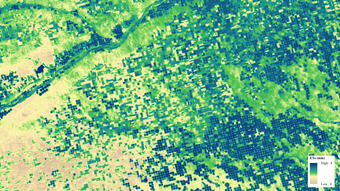
EROS scientists use Landsat satellite data to refine a technique called evapotranspiration mapping. It measures how much water crops are using across landscapes and through time.
These water-use maps are created using a computer model that integrates Landsat and weather data.

Agriculture
The United Nations’ Department of Economic and Social Affairs predicts 9.7 billion people will sit down every day to the global dinner table by 2050. If this prediction is correct, the world is going to need more crops, more livestock, and more efficient and sustainable agricultural practices.
Landsat data are already vital to domestic and international food production. Farmers use satellite data to analyze crop health and stress.

Food Security
Satellites are valuable assets for nations where food insecurities exist. Federal agencies provide timely, accurate data to participating countries to assist with the early detection of agricultural drought and to mitigate famine. Today, Landsat satellites are poised to take an even greater role in that mission.
Satellite imagery is a crucial component of the Famine Early Warning Systems Network (FEWS NET) project started in 1985 by the U.S. Agency for International Development (USAID).

Forest Health
Mountain pine beetles continue to ravage thousands of acres of forested lands in western North America. Landsat satellites bear witness to the onslaught in a way that neither humans nor most other satellites can see.
From the ground, the extent of forest land damage is simply too large for field observers to quantify. But 438 miles above the Earth, Landsat satellites pass over every forest in the country dozens of times a year—every year—creating a historical archive of clear, composite images that tells important stories of life and death in our Nation’s forests.

Wildfire
A wildfire’s devastation of forest and rangeland seldom ends when the last embers die. In the western United States, rain on a scorched mountainside can turn ash into mudslides. Debris flows unleashed by rainstorms can put nearby homes into harm’s way and send people scrambling for safety.
The infrared capabilities of Landsat satellite imagery provide vital information about potential dangers after a wildfire.

Industrialization
In his 1963 book, “The Quiet Crisis,” former Interior Secretary Stewart Udall lamented what he called the decline of natural resources in the United States under the advancements of industrialization and urbanization.
The planet seemed increasingly finite to Secretary Udall and others in the environmental movement. They argued that the United States needed to start managing its resources better. Udall eventually advocated to turn US remote-sensing technology toward Earth to better understand and document the consequences of the spread of humanity. In fact, over 60 years later, Landsat satellites do exactly that.

If you want to keep data safe, EROS is the place.
When the center started, digital wasn’t even a thing—all Landsat and aerial imagery was stored on film.
And it’s still in our lower level, shelves and shelves of film canisters in climate-controlled comfort, along with copies of every map ever created by the U.S. Geological Survey.
Now the ever-growing EROS archive stores over 74 petabytes of digital data, much of it available on the cloud. Not all of it comes from Landsat, though.
To learn more about where the rest of the data comes from, why it’s all now available at no cost to the public, and what type of data NASA keeps at EROS, read on!
Open Data Policy
There’s no such thing as time travel … yet.
But when the EROS archive was opened at no cost to researchers everywhere in 2008, we came pretty close. Suddenly, fire mappers had sufficient material to accurately trace the outlines of blazes over time. No longer constrained by budget limits, scientists had all the data they needed to focus on anything from agriculture to coastlines to urban areas.
Requests for imagery exploded, with 1 million scenes downloaded in Fiscal Year 2009 alone!
Click below to see full impact of the open data policy at EROS.

LP DAAC
In 1989, NASA launched its Mission to Planet Earth program.
But where to house the data from even more Earth-observing satellites? For one solution, NASA looked to its long-time Landsat partner, USGS, to jointly build an addition at EROS to have enough room to house the Land Processes Distributed Active Archive Center (LP DAAC). The addition opened its new front entrance doors in 1996.
Read the story to see how the addition doubled EROS’ footprint and LP DAAC contributed more to our knowledge about our planet.


For many, their first introduction to the power of Landsat imagery is of disastrous events.
Mount St. Helens. Chernobyl. The Yellowstone fires of 1988. The World Trade Center attacks. Glaciers breaking off and floating in the Antarctic Ocean.
Before and after shots capture the dramatic changes—and Landsat keeps looking long after the event to observe recovery and further changes.
Today, as part of the International Charter Space and Major Disasters, EROS provides data to the world wherever needed to help in disaster response.

Soaring high above Earth, Landsat satellites naturally have an international point of view.
EROS adopted that outlook, too, hosting its first International Workshop in June 1973—two months before the center’s grand opening!
Scientists were ambassadors of sorts, both at home in the United States and traveling abroad to teach others how to use Landsat and other imagery to benefit their countries.
Scroll down to see how these international partnerships developed into full-fledged programs.

International Training
While it’s not quite true that the world beat a path to EROS, the center’s doors have been open to thousands of international visitors and scientists over the years.
In fact, when they started up in 1973, EROS’ International Remote Sensing Workshops were practically the only way for foreign researchers to understand the value of Landsat data and study it themselves.
Take a look at the full story to learn about the cultural and scientific exchange between EROS staff and visitors from other countries.

When did EROS begin? Well, scroll through our timeline, and you’ll see the center opened August 7, 1973. But USGS scientists started thinking about it much earlier. Learn more here about the who, where, what and why—and above all the how of what EROS came to be.
To visit a certain decade directly, click the links here:
1960s | 1970s | 1980s | 1990s | 2000s | 2010s | 2020s


1966 - Proposing a Satellite: USGS scientists William Fischer, one of the country’s first photo-geologists involved in interpreting geologic features from aerial photography, and hydrologist Charles Robinove propose a remote sensing satellite program to William T. Pecora, USGS Director. The three then pitch the idea to Secretary of the Interior Stewart Udall.
September 21, 1966 - Project EROS Announced: Secretary of the Interior Stewart Udall announces "Project EROS (Earth Resources Observation Satellites)” in a press release.

1968 - The Sweet Spot: Southeast South Dakota is in the “sweet spot” to be the home of the data center for Project EROS — an area in the center of the country that would be best suited to receive transmissions from any part of the conterminous United States. Ironically, EROS does not become a ground station receiving data directly from space until 1987, when the Advanced Very High Resolution Radiometer (AVHRR) antenna on the roof is connected to National Oceanic and Atmospheric Administration (NOAA) satellites.
1968 - Political Heavyweights: South Dakota politicians have an edge in vying to house Project EROS: Senator Karl E. Mundt, a close friend of President Richard Nixon, and Representative Ben Reifel are each the ranking Republicans on their respective Interior Appropriations Committees.
1969 - "We'll Give the Land": Mundt and Reifel, with the help of South Dakota lobbyist Merlyn Veren, urge Sioux Falls business leaders to promote the city as the location for EROS. Al Schock, Russ Pohl, and Dave Stenseth, among others, form an EROS committee within the Sioux Falls Development Foundation. Delegation members travel to Washington, D.C., to lobby dozens of times. On one of those trips, Schock makes an inspired offer off the top of his head: “Well, we’ll give the land.”
March 1970 - Sioux Falls Is Picked: While Schock’s offer tipped the odds in favor of Sioux Falls, some political pressure still is needed. Mundt, who had suffered a stroke in 1969, sends a letter in March 1970 to his friend Richard “Dick” Nixon, to secure the EROS site for Sioux Falls and release the funding. On March 30,1970, a Mundt press release announces Sioux Falls has been chosen.

August 14, 1970 - A 20-Year Lease: After securing options to buy 318 acres from the Froseth and Hegge farms north of Sioux Falls, the Development Foundation offers to donate the land and to build the EROS Data Center under a 20-year lease/purchase agreement.
September 28, 1971 - The Downtown Office: Fewer than 20 employees begin work for EROS in the former Soo Hudson Building at the corner of Dakota Avenue and 10th Street (132 S. Dakota Avenue) in downtown Sioux Falls. Glenn Landis is the first EROS director.
April 14, 1972 - Groundbreaking: Pecora (now Undersecretary of the Department of the Interior) attends the groundbreaking ceremony for the new EROS facility. The groundbreaking is done by a mule-drawn plow. At this point, EROS employs 29 people.
July 23, 1972 - ERTS-1 Launches: ERTS-1 (later renamed Landsat 1) is launched at Vandenberg Air Force Base, California; a delegation from South Dakota attends. The number of EROS employees has grown to 58.
July 25, 1972 - First Images: Two days after the launch, Landsat 1 begins transmitting images to the NASA Goddard Space Flight Center in Greenbelt, Maryland. These images are then flown to Sioux Falls. Initial processing efforts are stymied because the negatives prove to be opaque and need a lot of work to be usable. Landsat 1 carried two sensors: the Multispectral Scanner (MSS) and the Return Beam Vidicon (RBV) camera. MSS images are found to be superior to RBV. Scientists and the general public begin to order photos.

January 11, 1973 - Early Discoveries: Discoveries continue to roll in as EROS workers develop film and review images. On January 11, 1973, “galloping glaciers” are observed on Mount McKinley; on January 23, volcanoes and glaciers in Iceland; in March and April, previously undetected faults are discovered in Tennessee and South Carolina. And on May 15, a press release notes what might be the first remote sensing land change observation: a comparison of the Mississippi River from October 1972, at normal flow, with the same territory flooded in March 1973.
June 1973 - International Training: The first international training course welcomes 33 scientists and engineers from a dozen countries. Eventually, a pattern for the workshops emerges: “We’d have a week or two of lectures and exercises, an academic approach. Then there would be a field trip. South Dakota is tailor-made for that because if you go from here to Deadwood, you hit it all: agricultural land, range land, an arid environment – the Badlands – and a mountainous forest area – the Black Hills,” according to former ERPS scientist Ron Beck. In the last week of the course, the international students would use Landsat images to help address real-world problems in their home countries. The international training courses were held biannually through the late 1980s and annually thereafter for many years.
August 7, 1973 - Building Dedication: 2,000 gather for the official dedication of the $6 million Karl E. Mundt Federal Building. Secretary of the Interior Rogers C. B. Morton gives the main address. Now 70 people are employed by EROS.

September 1973 - First Director: Al Watkins, the deputy program manager for NASA’s Earth Resources Program, is hired to be the chief of the EROS Data Center, allowing Glenn Landis to focus on the massive tasks of data production and distribution. Administration and data production move to the new facility; there are now 124 employees. A process that started in June results in Technicolor, Inc., being named as the first contractor at EROS, hired to oversee the onsite technical support staff. Other contractors soon followed.
1974 - Operational Facility: The new facility goes operational with 210 employees.
February 4, 1974 - Skylab & EROS: Science pilot Ed Gibson and two other astronauts return to Earth in an Apollo capsule after living for 84 days on Skylab during the third and longest manned mission of the space station, which was launched on May 14, 1973. Gibson and his crew members conducted 90 experiments before splashdown. Gibson later brings his expertise to EROS—where Skylab imagery is archived—as SAIC’s manager of technical services.
1975 - Work with South Dakota: EROS and the state of South Dakota work together to develop a program to provide land cover and natural resource information to assist land managers and policy makers. The first area chosen was eastern South Dakota.
January 10, 1975 - The Blizzard: A blizzard hits the area and traps 30 employees at EROS on Friday, January 10. Employees wait out the storm by eating at the cafeteria, creating playing cards from computer data cards, and watching the Super Bowl. The roads were cleared on Sunday, January 12, and thereafter, the administration stocked the center with blankets and other emergency supplies.

January 14, 1975 - ERTS Becomes Landsat: The ERTS program is renamed Landsat, a decision made unilaterally by NASA leading up to the launch of Landsat 2.
January 22, 1975 - Landsat 2 Launches: Landsat 2, essentially a twin to Landsat 1, launches. The satellite, originally planned to last one year, provides images for seven years.
April 16, 1975 - Snapshot of EROS: Staff now exceeds 300, per an April 16 Argus Leader newspaper supplement on Sioux Falls progress. Two new microfilm processors (B&W and color) will be supplemented by a new microfilm camera. Canada and Brazil already have ground stations, and Zaire, Iran, and Italy have signed agreements to do so. Researchers include “scientists in mineral resources and civil works survey, land use and mapping, forest and rangeland management and agriculture and soils inventory, with plans to acquire a water resources specialist.” Projects include flood and flood-plain analyses; an inventory of shelterbelts in the Plains states; an environmental evaluation of strip mines; and assistance for the Algerian Ministry of Hydraulics to establish remote sensing planning. Work on a 15,000 square-foot shop and warehouse is scheduled to start November 1.
April 16, 1975 - EROS to Distribute Data: Agreement with NASA is finalized that ensures EROS will distribute data rather than NASA's Goddard Space Flight Center.
1976 - Alaska, Arizona Studies: Major studies at this time involving field validation include Bureau of Land Management (BLM) vegetation classification of 2.5 million acres in Mount McKinley National Park (now Denali National Park) in Alaska, and the Arizona Vegetation Research Inventory (AVRI). The AVRI study includes identifying the best possible habitat for a potential transplant of big horn sheep into Arizona.

1976 - Digital Images: About this time, the I²S scanning system allows staff to scan Landsat film chips into a computer; the resulting images can then be used to make color composites. It will be followed by the Image 100, which reads images off magnetic tapes and enables spectral signature classification. Scientists could then group ground features by spectral characteristics, classifying bare ground, grassland, forest, and water.
1977 - Training Other Agencies: During this era, the training and assistance section’s effort to train staff from other federal agencies intensifies. The idea is to educate ecologists, geologists, hydrologists, planners and resource managers on the best way to incorporate and interpret remotely sensed data to be used in their work. “To sell ourselves, we would do a little bit of their project on our own, with our own money, and take it to them and say ‘Now look at this – if you did this and this, or if we helped you to continue with this, here are some of the benefits you’d get from it.’ They would see it firsthand, and … we’d hook ’em!” Jim Sturdevant.
February 1977 - INORAC Developed: In February, the INORAC (Inquiry, Order, and Accounting) system is implemented. Developed in-house to track repeat customers, standing accounts, orders and payments, it is also used to create orders for the photo lab as well as shipping labels.
August 1977 - Mapping Fires: The ability of Landsat image analysis to help with fire management is demonstrated when a dry summer in Alaska results in more than 500 forest fires; by August 1977, the total acreage burned is estimated at 2 million acres. Because Bueara of Land Management (BLM) had previously used Landsat imagery to create a reindeer range inventory of northwest Alaska, the agency knows which rangeland to protect and which areas should be left to burn. The EROS Application Assistance Facility personnel in Alaska provide current imagery of fires in progress to users and make a standing request for imagery of all fire areas.
March 5, 1978 - Landsat 3 Launches: Landsat 3 is launched; together with Landsat 2, it provides an entire map of Earth every 9 days. The MSS on Landsat 3 provides an additional spectral band. The RBV camera on board produces four images.
March 30, 1978 - Training a University: Nine faculty members and graduate students from the Geology Department of Texas A&M attend an introductory training course in geological remote sensing techniques at EROS.

June 19, 1978 - Working with Universities: EROS works with the University of Michigan School of Natural Resources to host an open enrollment Vegetation Remote Sensing Workshop in northern Michigan. That same week, the Graduate School of Harvard University holds a basic remote sensing workshop on “Terrain Analysis,” the first-ever workshop at EROS conducted by an outside group.
1979 - Vanpooling Association: In response to the energy crisis, the EDC (EROS Data Center) Employee Association successfully applies for a ride-share grant and starts the EROS Vanpooling Association. The nonprofit corporation eventually owns seven vans that serve the Sioux Falls metro area, with more than 90 participants who pay \$35 a month for door-to-door service to and from the center. The EROS program wins a federal carpooling award in 1984 and is noted as being the only employee-owned program in the U.S. government. The program continues until the COVID pandemic on March 17, 2020. The last EROS vans are sold in the summer of 2021.
January 25, 1979 - Domsat Brings Digital Data: The Domsat antenna is installed to receive Landsat 3 MSS data directly from NASA’s Goddard Space Flight Center in Maryland. It will become operational in May after testing, ending the era of receiving film and computer tape via mail or commercial aircraft and greatly improving data processing time.
November 1979 - Commercialization Begins: President Jimmy Carter issues a directive transferring Landsat operations to National Oceanic and Atmospheric Administration (NOAA, part of the Department of Commerce), and that EROS might have to transfer responsibility for archiving, processing, and distribution of Landsat data to NASA Goddard Space Flight Center (GFSC) by 1983-1984. The directive also recommends that the operation of satellites and data distribution be turned over to the private sector over a 10-year period. During the next decade, acquisitions of data were made only when paid requests are submitted to NOAA, meaning the continuity of data acquisitions was lessened dramatically.
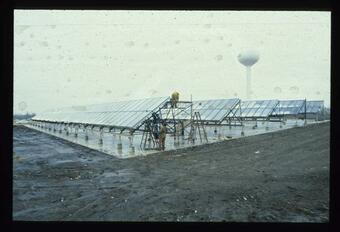
1980 - Solar Water Heating: The solar energy water system at EROS becomes operational. Construction started two years earlier after a \$646,600 contract was approved by the Sioux Falls Development Foundation. Estimates predict that the system will contribute 58.5% of the energy required to preheat the daily 20,000 gallons of water used in the photographic processes and will have an economic pay-back in 10 years. A federal grant of \$500,000 helped fund the 10,000 square feet of solar panels, one of the largest in the United States.
May 18, 1980 - Mount St. Helens: Mount St. Helens erupts, and Landsat images reveal the extent of the ash months after the cataclysmic event. The volcano has remained active over time. In 2017, geologist Angie Diefenbacher looks to the expertise of EROS archivists to accurately preserve 18,917 frames of aerial footage from the 1980 eruption that she had found in a file cabinet.
1981 - Computer Compatible Tapes: EROS helps set the standard for computer compatible tapes (CCTs) that will be used worldwide.
July 16, 1982 - Landsat 4 Launches: Landsat 4 is designed to be retrievable from space by the shuttle program and is the first civilian aircraft with a GPS receiver, although only 4 of 24 GPS satellites were in orbit at its launch. Its major advance over previous Landsats, though, is the Thematic Mapper (TM), an improved version of the Multispectral Scanner (MSS).
February 1983 - EOSAT Tapped: President Ronald Reagan signs a decision memorandum authorizing a formal Landsat commercialization effort. A Source Evaluation Board for Civil Space Remote Sensing (SEB/CSRS) launches a competitive process to find a company to run the program. The selection is narrowed down to Eastman Kodak and EOSAT by 1984, and when Kodak drops out of the process in August of that year, EOSAT, a joint venture between Hughes Aircraft and RCA (one source says GE), is the only contender remaining.

1984 - Pressler Advocates for EROS: South Dakota Senator Larry Pressler hands President Reagan an image of EROS. Pressler proves to be a staunch advocate for EROS both as a congressman and a senator.
March 1, 1984 - Landsat 5 Launches: Landsat 5 is launched. Designed to last three years, Landsat 5 will remain in operation for more than 29 years before being decommissioned June 5, 2013. In that time, it orbits Earth over 150,000 times and transmits 2.5 million images. The satellite’s longevity is due in part to an extra fuel tank added in hopes that it could navigate to meet up with the planned space shuttle repair and refuel mission that never came to fruition. Landsat 5 is recognized by the Guinness Book of World Records as the longest-operating Earth observation satellite.
June 1984 - Land Remote Sensing Act: The Land Remote Sensing Act of 1984 launches the commercialization of Landsat data and stirs up uncertainty for EROS employees; an Office of Landsat Commercialization is even set up. But a Memorandum of Agreement between NOAA and USGS in response to the act outlines parameters that ultimately ensure the future of EROS. Most importantly, EROS is designated to be THE sole archive for all remotely sensed data.
1985 - Fishing at EROS: Bass and bluegill are stocked in Lake EROS, the largest pond at the center, which contains water that has gone through the effluent process and is tested to ensure it doesn’t contain extra chemicals from photo processing. The 15 acre, 21-foot-deep pond becomes a popular fishing hole for employees and their children.
April 16, 1985 - US-China Cooperation: The United States and China sign a protocol to promote cooperation in remote sensing, cartography, geographic information systems (GIS), and other areas. Two scientists from EROS travel to the Ningxiang area in Hunan Province; the following year, Chinese scientists visit the Black Hills in South Dakota and spend time at EROS. The exchange continues through 1989 and results in several published papers and an overview of the project published in 1992.

May 1986 - Chernobyl: EROS director Al Watkins is interviewed by Dan Rather on CBS Evening News, explaining how scientists used Landsat imagery to assess damage from the Chernobyl Nuclear Power Plant in Ukraine, which was then part of the Soviet Union. EROS confirms that the USSR’s reporting of what happened is correct. EROS follows up in 1987 by assessing radiation damage to pine trees in the area.
1987 - EROS Joins FEWS: The U.S. Agency for International Development (USAID) asks EROS to review the Famine Early Warning System (FEWS) that had been established in 1985 in some sub-Saharan countries. EROS today continues to provide USAID support with the FEWS Network, which is the longest-running continuous project in EROS history.
1987 - The EROS International Program: The EROS International Program is introduced. Since 1987, the program has had many impacts in the world, especially in Africa; these include the extensive training conducted in many countries in 3 different languages; technology transfer of remote sensing and geospatial technology, some of that done through our Niger field office, and through cooperative projects; long–term presence and partnerships in West Africa (1987 to present), reverse technology transfer of tools and experience back to the United States; informing US economic development policy at several USAID Missions in Africa; bringing awareness of environmental and land use change to heads of state and cabinet levels in West Africa; and documenting and publishing case studies that are major success stories, among numerous other projects.
May 1987 - AVHRR Antenna: EROS assumes satellite ground station status as NOAA’s Advanced Very High Resolution Radiometer (AVHRR) antenna is installed on the roof and begins acquiring data directly from NOAA 9 and 10. EROS engineers design and install ADAPS, the AVHRR Data Acquisition and Processing System, collecting scenes that open doors to science projects that become the hallmarks of EROS such as NDVI, support the FEWS Network, and various drought-mapping efforts. Data is received through the AVHRR antenna until it ceases working in 2017. It is removed in 2019.

July 1988 - Yellowstone National Park Fires: Landsat imagery showing Yellowstone National Park Fires help scientists monitor the forested areas.
1989 - South Dakota Centennial: The South Dakota Centennial Wagon Train stops at EROS during its tour of the state during its 100th year anniversary.
March 1, 1989 - Quayle Backs EROS: Shortly after President George H.W. Bush takes office, Vice President Dan Quayle is put in charge of the National Space Council. When NOAA gives the order on March 1 to shut down Landsats 4 and 5 in 30 days, 100 members of Congress send Quayle a letter calling to preserve it. Later that month, Quayle announces that NASA, the Department of Defense, and other agencies will pay most of the money needed for the program if EOSAT provides the rest. In June, thanks to a unanimous recommendation from the Space Council to provide funding through 1990, the Bush administration announces a civil remote sensing policy will be retained.
August 28, 1990 - LP DAAC Starts: The USGS and NASA announce, in a NASA flag raising at EROS, that as part of NASA’s “Mission to Planet Earth” program, EROS will host the NASA Land Processes Digital Active Archive Center (LP DAAC), which would require an addition to the existing EROS building and additional staffing.
1991 - The Global Resource Information Database: EROS becomes the North American location for the United Nations’ Environment Programme’s Global Resource Information Database (UNEP/GRID) whose task was to bring data, experience, and knowledge to applications of remote sensing and geospatial science to the globe. A series of environmental atlases was one of the high profile research outputs from UNEP/GRID while at EROS.
1991 - MRLC Acquires Imagery: The Multi-Resolution Land Characteristics (MRLC) Consortium is initiated to help pool agency resources to acquire Landsat imagery for a national land cover dataset. Founding members were the USGS, NOAA and the EPA.
October 1992 - Repeal of Commercialization: Congress passed the Land Remote Sensing Policy Act of 1992, introduced by South Dakota Senator Larry Pressler, to repeal the commercialization of Landsat, extend the life of the program beyond 2000, and designate EROS as the National Satellite Land Remote Sensing Data Archive. As a result, EROS would be asked to process, distribute, and archive data from the planned Landsat 7 satellite, in addition to installing an antenna and serving as the primary ground station for Landsat 7 data.

May 31, 1994 - Groundbreaking for Addition: A groundbreaking is held at EROS for the 65,000-square-foot building addition that’s necessary to house LP DAAC and the Landsat 7 archive. It features the same horse-drawn plow used for the 1972 groundbreaking for the original building. Festivities also include a ceremonial burning of EROS’ 20-year mortgage. The current employee count stands at 343. There are 3 million satellite images and 8 million aerial photos in the archive.
1996 - Declassified Satellite Imagery: EROS receives images collected by the CORONA, ARGON, and LANYARD intelligence satellite systems, now declassified, and makes the data available to the public via one of the first online search and discover portals, the Global Land Information System (GLIS).
August 19, 1996 - Dedication Ceremony for Addition: EROS holds a dedication ceremony to formally open the new addition, hosted by USGS Director Gordon Eaton.
1997 - Global Land Cover: The first detailed Global Land Cover Data Set is completed using 1 km AVHRR data.
June 6, 1997 - Finally a Ground Station: A new 10-meter antenna is set in placed. It fulfills EROS’s long-intended purpose of being a Landsat ground station, specifically for the planned Landsat 7 satellite.

July 13, 1997 - Horrendous Hailstorm: A brief but destructive storm with hail up to the size of softballs renders the new Landsat antenna unusable, destroys the solar array behind the building and vehicles, and cracks atrium roof panels, among other damage. The damage totals more than $1 million.
1998 - Elevation Accomplishment: EROS completes the first version of the National Elevation Database (NED). NED served as the flagship elevation product for the USGS from 1999 to 2014.
January 1998 - New Emergency Response Program: EROS establishes the Emergency Response Program, which will involve improving the mechanisms of data delivery and developing partnerships with emergency response agencies.
1998 - Pilot AmericaView Program: OhioView (precursor to AmericaView) begins as a pilot program with a group of Ohio universities called the OhioView Consortium. The goal of the pilot is to promote the distribution and application of government data for public use, which would also help overcome the cost and data access problems historically faced by the research community interested in using remote sensing data. EROS was to initiate a pilot project with the consortium to providing a copy of remote sensing data—including upcoming Landsat 7 data—that could be shared by users in the consortium. To provide access to high-volume data and products, EROS had to enhance its networking, information access and delivery and product generation infrastructure.
September 19, 1998 - 10,000 Celebrate EROS's 25th Anniversary: EROS hosts an open house for 10,285 guests to celebrate its 25th anniversary with the theme, “Exploring a Changing Planet.” Special guest and speaker was former NASA astronaut Mary Cleave; 350 employees served as volunteers. Activities included competitive and fun runs, activity booths, clowns, musicians, Native American dancers and food vendors. Related events included a juried art show with entries from across the nation, staff visits to 6th- and 7th-grade classrooms and the publication of the commemorative book “What It Took: A History of the U.S. Geological Survey’s EROS Data Center” by Rebecca Johnson.

April 15, 1999 - Launch of Landsat 7: Landsat 7 launches from Vandenberg Air Force Base in California, marking the beginning of an era in which EROS finally achieves direct reception with a Landsat satellite, 26 years after it opened in an optimal location for doing so. Landsat 7 carried the Enhanced Thematic Mapper Plus instrument, with improvements for monitoring land cover and surface temperature. On April 18, EROS processes the first signals from Landsat 7, including imagery of southeastern South Dakota.
December 18, 1999 - Launch of Terra: NASA launches the Terra satellite in the Earth Observing System series containing MODIS and ASTER instruments. Data from the instruments is stored at and distributed from the LP DAAC, and EROS scientists will use the data in a variety of projects.
2000 - NLCD Debuts First Dataset: The first National Land Cover Dataset (NLCD), based on Landsat 5 data, is completed and available for distribution.
March 23, 2000 - EarthExplorer Is Born: EarthExplorer becomes operational, containing Landsat MSS, TM and ETM+ data and eventually National Aerial Photography Program imagery, National High Altitude Photography, USGS paper maps, digital raster graphics, digital orthophoto quadrangles, Corona declassified satellite photography and the Digital Elevation Model datasets.
2001 - USGS Runs Landsat 7: The USGS assumes flight operations responsibility from NASA for Landsat 7 at EROS and NASA Goddard Space Flight Center.
2001 - Mapping Wildfires for BAER: EROS begins working with the U.S. Forest Service to map significant wildfires on the Department of Interior (DOI) and Forest Service lands for Burned Area Emergency Response (BAER) teams using satellite imagery.

September 11, 2001 - 9-11 Effects on EROS: EROS is affected by the 9-11 terrorist attacks in many ways. U.S. government facilities were shut down as a precaution, so employees on-site drove back home that morning. Representatives from firms considering bidding on the upcoming Landsat 8 mission had flown in to tour and learn more about EROS that day; meeting space was secured at Augustana instead. A research-focused symposium was moved from the EROS auditorium to the Holiday Inn City Centre that day. The airline shutdown across the United States left traveling EROS employees struggling to return home and EROS visitors trying to figure out how to leave Sioux Falls. In the aftermath of the attacks, EROS provided support for different federal and state agencies’ requests, processing and providing access to satellite, aerial and lidar imagery. Landsat 7 captured the smoke still rising above Ground Zero in a September 12 image.
November 9, 2001 - Earth as Art Debuts: The first Earth As Art exhibit of Landsat imagery debuts at the Washington Pavilion in Sioux Falls, the result of USGS contractors Jon Christopherson, Pat Scaramuzza and Ron Hayes keeping a collection of interesting Landsat 7 images at their desks. The first Earth As Art collection earns a USGS Shoemaker Award for Communication Product Excellence.
2003 - AmericaView Officially Forms: AmericaView becomes an incorporated nonprofit, expanding OhioView’s intent to the national level with 10 founding members: Arkansas, Georgia, Kansas, Mississippi, Nebraska, Ohio, South Dakota, Texas, West Virginia, and Wyoming. The USGS had begun implementing AmericaView nationwide in 2000, with EROS providing infrastructure activities.
May 31, 2003 - Landsat 7 Letdown: The Scan Line Corrector fails on Landsat 7’s Enhanced Thematic Mapper Plus (ETM+) sensor, resulting in data gaps. EROS worked to identify mitigation strategies to fill in missing data. Ultimately, the price per Landsat scene was reduced to compensate, from \$600 to \$250. Demand and revenue for Landsat 7 data decreased, affecting the EROS workforce.

2004 - LANDFIRE Charter: The Landscape Fire and Resource Management Planning Tools (LANDFIRE) program hosted at EROS is chartered by the Wildland Fire Leadership Council after a prototype began in 2002.
January-September 2005 - Photo Lab Closes: The Photo Lab at EROS is closed, ending a 32-year era in the EROS building and 33 years of photographic processing. The Photographic Laboratory equipment and supplies are removed.
2006 - MTBS Maps Wildfire Severity: EROS and the U.S. Forest Service begin the initial Monitoring Trends in Burn Severity project to map and assess the burn severity of all large fires in the United States between 1984 and 2010 using Landsat scenes. This initial effort was completed in 2012, with 14,900 fires mapped, but updates continue today.
2006 - Evaporation Model Begins: An evapotranspiration model is developed at EROS, published in 2007 as the Simplified Surface Energy Balance approach and improved in 2013 to the Operational Simplified Surface Energy Balance (SSEBop) approach. It went on to be used in a variety of ways, including the USGS Water Census program for the 2010 WaterSMART initiative and the OpenET collaborative model that debuted in 2021.
2006 - FORE-SCE Effort Forecasts Future: The FORE-SCE (FOREcasting SCEnarios of land-use change) model is developed at EROS using land cover data and analysis to model future effects of land use. Projections at 250m for the conterminous United States from 1992-2100 are published in 2014.
April 21, 2008 - Open Data Policy Begins: The USGS sends out a technical announcement about the timeline for opening the Landsat Archive for internet distribution of Landsat data at no charge. This followed the January signing of the new Landsat Data Distribution Policy by Barb Ryan of the USGS and Mark Freilich of NASA. Distribution of Landsat data spiked after the open data policy, with more than a million Landsat scenes downloaded in FY 2009, compared to 25,000 scenes delivered in FY 2001, the most in one year before the 2008 announcement. EROS also works to deliver the rest of its remote sensing data at no charge over the internet.
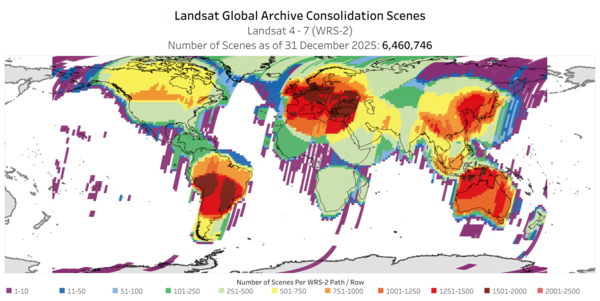
2010 - Uniting Landsat Data: The Landsat Global Archive Consolidation (LGAC) initiative begins, with the intention of gathering at EROS far-flung Landsat data stored at ground station outposts and adding the data to the archive to fill gaps. Millions of scenes have been added, most unique to the archive.
2010 - Carbon Research: The USGS releases a methodology for a national assessment of biologic carbon sequestration called LandCarbon. The program, mandated by the Energy Independence and Security Act of 2007, included numerous research studies at EROS.
November 2012 - End of Landsat 5: The legendary Landsat 5 satellite experiences its final setback when a gyroscope fails. In December 2012, the USGS announces that Landsat 5 will be decommissioned. The satellite transmits its last image January 6, 2013. The USGS completes the satellite decommissioning by issuing the last command—to shut down the transmitter—on June 5, 2013. On February 10, 2013, Landsat 5 is recognized by the Guinness Book of World Records as the “Longest-operating Earth Observation Satellite,” for 28 years and 10 months of service.
February 11, 2013 - Launch of Landsat 8: Landsat 8 launches from Vandenberg Air Force Base with much improved instruments that collect imagery in new and improved spectral bands: the Operational Land Imager (OLI) and the Thermal Infrared Sensor (TIRS).
2014 - LCMAP Begins: EROS begins the development of Land Change Monitoring, Assessment, and Projection (LCMAP) to provide users with ready-to-use Landsat-based land change and land use data on a continuous schedule.
2016 - Collection 1 Released: Landsat Collection 1 is released, consisting of Level-1 data dating from 1972. The implementation of Collections represents a significant change in the management of the USGS Landsat Archive by ensuring consistent quality through time and across instruments, along with additional changes like metadata and file names.
May 2017 - Calibration Center Forms: The EROS Calibration Center of Excellence (ECCOE) becomes formally organized and initiated, with the aspiration of being the leading organization for improving the accuracy, precision and efficiency of optical satellite and sensor calibration, characterization, and cross-calibration.
February 2019 - Level 3 Products Released: Landsat Level-3 burned area, dynamic surface water extent, and fractional snow and ice cover science products become available to the public.
2020 - LCMAP Releases First Product: The USGS Land Change Monitoring, Assessment and Projection (LCMAP) initiative releases its Collection 1 product suite, putting 33 years of satellite-based land change data for the U.S. into the public domain.
2021 - Landsat Collection 2, Commercial Cloud Access: Landsat data becomes available in the commercial cloud after the processing of Collection 2, which took just five weeks using the cloud.
September 27, 2021 - Launch of Landsat 9: Landsat 9 is launched from Vandenberg Space Force Base in California, very similar in design to Landsat 8.
February 10, 2022 - Landsat 9 Data Debuts: Landsat 9 data first becomes available through EROS.
December 2022 - Landsat Next Details Announced: Landsat Next, a trio of satellites that will continue the program’s remote sensing legacy, is announced. Launching three satellites will create the opportunity for a full mapping of Earth every six days with additional multispectral bands.