
The quality of the water we drink can potentially impact our health. The USGS has several programs and cooperative projects that characterize the quality of selected rivers and aquifers used as sources of drinking water to community water systems in the United States.
Images
Explore water-related photography, imagery, and illustrations.
Filter Total Items: 2560

Drinking water from tap
The quality of the water we drink can potentially impact our health. The USGS has several programs and cooperative projects that characterize the quality of selected rivers and aquifers used as sources of drinking water to community water systems in the United States.

Scientist working to retrieve sampling gear from groundwater well.
Scientist working to retrieve sampling gear from groundwater well.JJ Thordsen (USGS) and a wireline operator retrieving downhole vacuum sampler from a characterization well near a CO2 injection well at Citronelle oil field, Alabama.
Scientist working to retrieve sampling gear from groundwater well.
Scientist working to retrieve sampling gear from groundwater well.JJ Thordsen (USGS) and a wireline operator retrieving downhole vacuum sampler from a characterization well near a CO2 injection well at Citronelle oil field, Alabama.

Iron Reducing Bacteria
Iron Reducing Bacteria
FeRB isolated using a roll bottle technique from the former Uranium Mine near Ronneburg, Germany, Photo credit: Denise Akob, USGS
Iron Reducing Bacteria
FeRB isolated using a roll bottle technique from the former Uranium Mine near Ronneburg, Germany, Photo credit: Denise Akob, USGS

Ocoee River, Tennessee
Ocoee River, Tennessee

Bath Creek, Bath County, VA
Bath Creek, upstream of Blowing Springs Campground, George Washington National Forest, Bath County, VA.
Bath Creek, upstream of Blowing Springs Campground, George Washington National Forest, Bath County, VA.

Stormflow through a Culvert in Hampton Roads, Virginia
Stormflow through a Culvert in Hampton Roads, VirginiaThe Storm Drain at Rivers Ridge Circle near Newport News, VA during a hihg flow event triggered by a rainstorm. This site is a part of the Hampton Roads Regional Water Quality Monitoring Network.

Snow dapples the banks on Brodhead Creek
Snow dapples the banks on Brodhead Creek near Analomink, PA. This stream reach, and reaches on other streams were surveyed as part of a geomorphic dataset to determine channel dimensions and allow new estimates of bankfull discharge and channel dimensions at U.S.
Snow dapples the banks on Brodhead Creek near Analomink, PA. This stream reach, and reaches on other streams were surveyed as part of a geomorphic dataset to determine channel dimensions and allow new estimates of bankfull discharge and channel dimensions at U.S.

Rio Chama above Abiquiu Dam
Snowy road on the way to Rio Chama above Abiquiu Dam (08286500)
Snowy road on the way to Rio Chama above Abiquiu Dam (08286500)

USGS streamgage 13210810, Fifteen Mile Creek near Middleton, Idaho.
USGS streamgage 13210810, Fifteen Mile Creek near Middleton, Idaho.USGS streamgage 13210810, Fifteen Mile Creek near Middleton, Idaho, is one of 10 streamgages the USGS has installed on Treasure Valley drains in cooperation with the Idaho Department of Water Resources. Data from these streamgages will be incorporated into a groundwater-flow model of the Treasure Valley aquifer system.

Aerial view of the Mississippi River near Vicksburg, Mississippi
Aerial view of the Mississippi River near Vicksburg, MississippiDCIM\100MEDIA\DJI_0049.JPG

Streamgage in Connecticut
A beautiful capture of a streamgage at Bunnell Brook near Burlington, CT.

Rio Brazos near Tierra Amarilla, NM
Hydrologic technician Lindsay Hastings took this photo of the Rio Brazos near Tierra Amarilla, New Mexico during her first field trip as a streamgager with the New Mexico Water Science Center. Did you know that New Mexico was the birth place of streamgaging?
Hydrologic technician Lindsay Hastings took this photo of the Rio Brazos near Tierra Amarilla, New Mexico during her first field trip as a streamgager with the New Mexico Water Science Center. Did you know that New Mexico was the birth place of streamgaging?

Paragnetina immarginata, Dawson County, GA
The USGS national invertebrate reference collection serves as an evaluation tool for verification of invertebrate identifications. Invertebrate example, Paragnetina immarginata from Dawson County, Georgia.
The USGS national invertebrate reference collection serves as an evaluation tool for verification of invertebrate identifications. Invertebrate example, Paragnetina immarginata from Dawson County, Georgia.

Installing a rapid deployment gauge to track Hurricane Matthew impacts
Installing a rapid deployment gauge to track Hurricane Matthew impactsUSGS hydrologic technician Jym Chapman (above) installs a rapid deployment gauge to measure water-surface elevation and other data in Myrtle Beach, South Carolina, prior to Hurricane Matthew’s approach in October 2016. Hydrologist Tim Pojunas (below) measures an elevation reference point used to calibrate the newly installed RDG.

Making a discharge measurement with a flowtracker
USGS hydrologist Amy Simonson making a discharge measurement with a flowtracker in a Long Island stream.
USGS hydrologist Amy Simonson making a discharge measurement with a flowtracker in a Long Island stream.

Kansas River at De Soto
A look at the Kansas River from its side. On the other side ofthe river trees and power lines can be seen as well as a bridge crossing the river.
A look at the Kansas River from its side. On the other side ofthe river trees and power lines can be seen as well as a bridge crossing the river.
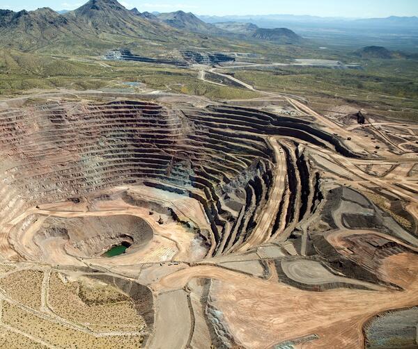
Freeport_McMoRan-Safford_Mine_photo.jpg
Photograph of Freeport McMoRan-Safford Copper Mine in Arizona. Photograph taken by Thomas J. Porter (USGS) on September 19, 2016, Latitude 32.85992 deg N, Longitude -109.622
Photograph of Freeport McMoRan-Safford Copper Mine in Arizona. Photograph taken by Thomas J. Porter (USGS) on September 19, 2016, Latitude 32.85992 deg N, Longitude -109.622

Looking Down From the Top of Detroit Dam
North Santiam River Valley downstream of Detroit Dam, as viewed from the top of Detroit Dam.
North Santiam River Valley downstream of Detroit Dam, as viewed from the top of Detroit Dam.

GPR and Broadband Electromagnetic Induction
USGS scientists conduct field work in the foothills of the Brooks Range in Alaska. Hydrologist Eric White (left) is collecting ground-penetrating radar (GPR). Research Hydrologist Martin Briggs (right) is collecting broadband electromagnetic induction data. The flowing water visible in the background is groundwater discharging at a spring. (October 2016)
USGS scientists conduct field work in the foothills of the Brooks Range in Alaska. Hydrologist Eric White (left) is collecting ground-penetrating radar (GPR). Research Hydrologist Martin Briggs (right) is collecting broadband electromagnetic induction data. The flowing water visible in the background is groundwater discharging at a spring. (October 2016)

Measuring streamflow
Neil Yobbi, U.S. Geological Survey hydrologic technician, uses an Acoustic Doppler Velocimeter to measure stream flow on Curlew Creek in Tampa, Florida. While Hurricane Hermine might have made landfall almost 200 miles away in St.
Neil Yobbi, U.S. Geological Survey hydrologic technician, uses an Acoustic Doppler Velocimeter to measure stream flow on Curlew Creek in Tampa, Florida. While Hurricane Hermine might have made landfall almost 200 miles away in St.

Rain Gage
Rain gage on Long Island