Threat Forecasting
Threat Forecasting
Filter Total Items: 20
Preparing for Potential Emergence of New World Screwworm in the U.S.
The USGS National Wildlife Health Center (NWHC) is supporting the Department of the Interior’s (DOI) preparedness planning for New World screwworm (NWS), a re-emerging parasitic disease that is spreading north from Central America.
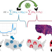
Advancing Risk Modeling for Highly Pathogenic Avian Influenza
Ongoing global outbreaks demonstrate the capacity of highly pathogenic avian influenza virus (HPAIV) to impact poultry, wild birds, and even human health. USGS research is advancing the understanding of the spatial and temporal interface between wild and domestic bird populations from which these viruses emerge to aid biosecurity planning and outbreak response.
Battling Invaders: Invasive Species Detection with eDNA
Early detection equals stronger protection. DNA in the environment is the front line against invasive species.
By
Ecosystems Mission Area, Biological Threats and Invasive Species Research Program, Species Management Research Program, Alaska Science Center, Columbia Environmental Research Center, Eastern Ecological Science Center, Forest and Rangeland Ecosystem Science Center, Fort Collins Science Center, Great Lakes Science Center, National Wildlife Health Center, Northern Prairie Wildlife Research Center, Northern Rocky Mountain Science Center, Pacific Island Ecosystems Research Center, Southwest Biological Science Center, Upper Midwest Environmental Sciences Center, Western Ecological Research Center (WERC), Western Fisheries Research Center, Wetland and Aquatic Research Center
Key Values of a Century of EESC Science
The USGS Eastern Ecological Science Center (EESC) is rooted in a proud tradition of service to the nation—advancing science that informs the conservation and management of fish, wildlife, and habitats across the eastern United States and beyond. Our mission is clear: deliver reliable, partner-driven science that supports natural resource decisions today, while ensuring these resources remain...
From Water, Soil, and Air: Building USGS Leadership in Environmental DNA (eDNA)
The USGS is a pioneer in environmental DNA (eDNA) science, applying cutting-edge molecular tools to identify, detect, or track species, monitor ecosystems, and safeguard biodiversity.
By
Ecosystems Mission Area, Biological Threats and Invasive Species Research Program, Environmental Health Program, Species Management Research Program, Alaska Science Center, Columbia Environmental Research Center, Eastern Ecological Science Center, Forest and Rangeland Ecosystem Science Center, Fort Collins Science Center, Great Lakes Science Center, National Wildlife Health Center, Northern Prairie Wildlife Research Center, Northern Rocky Mountain Science Center, Pacific Island Ecosystems Research Center, Southwest Biological Science Center, Upper Midwest Environmental Sciences Center, Western Ecological Research Center (WERC), Western Fisheries Research Center, Wetland and Aquatic Research Center , Pacific Northwest Environmental DNA Laboratory
Using Global Telemetry to Understand Avian Movement and Migration
USGS researchers are collaborating with partners around the globe to leverage new and existing telemetry data to answer broad scale questions about factors influencing avian movement and migration.
Deriving Spatial and Temporal Waterfowl Inputs for Disease Risk Modeling
USGS is creating spatially and temporally explicit inputs to improve avian influenza transmission risk modeling. This project places special emphasis on wild bird distribution and abundance models as well as avian influenza prevalence models.
Developing Waterfowl Distribution and Abundance Models to Inform Avian Influenza Transmission Risk
USGS researchers are developing novel methods to improve our understanding of waterfowl distributions and abundance across the United States to inform a variety of ongoing disease studies. Understanding the distribution of wild waterfowl is a critical component to assessing avian influenza transmission risks across the landscape.
North American Bat Monitoring Program (NABat)
Bats are essential contributing members of healthy, functioning ecosystems. They perform numerous ecosystem services like insect pest control and plant pollination, and provide enormous economic benefits through ecotourism, medical research, and novel biotechnologies. North American bats face unprecedented threats including habitat loss and fragmentation, white-nose syndrome, and wind energy...
Using Telemetry to Understand Overlap in Habitat Use Between Waterfowl and Agricultural Birds in North America
USGS researchers are using telemetry to improve our understanding of how wild birds move throughout their environments and the potential implications for disease transmission within and to domestic poultry.
INHABIT: A web tool for invasive plant management across the contiguous United States
INHABIT is a desktop-optimized web application and decision support tool with mapped and tabular summaries of habitat suitability models for over two hundred fifty terrestrial invasive plant species of management concern across the contiguous United States. It is the product of a scientist-practitioner partnership and is designed to facilitate enhanced invasive species management actions...
Assessing the Proliferation, Connectivity, and Consequences of Invasive Fine Fuels on the Sagebrush Biome
Invasive annual grasses can replace native vegetation and alter fire behavior, impacting a range of habitats and species. A team of researchers from the U.S. Geological Survey, Colorado State University, the Bureau of Land Management, and the U.S. Fish and Wildlife Service are working to identify factors that influence changes in the distribution and abundance of invasive annual grasses (IAGs)...


