
Early detection, risk assessment, and integrated control technologies
Invasive Carp
Invasive Carp
Great Lakes Water Quality
HABs
HABs
Toxic Substances and Areas of Concern
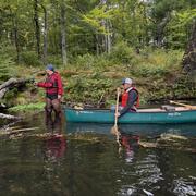
Tree Swallows
Tree Swallows
Deep Water Fisheries Research
Large Vessels
Large Vessels
This is just some of the great work being done in Region 3
Great Lakes
Great Lakes
Midcontinent Region
The Midcontinent Region covers activities in the geographic area of Illinois, Indiana, Kansas, Kentucky, Michigan, Minnesota, Montana, Nebraska, North Dakota, Ohio, South Dakota, Wisconsin, and Wyoming. We conduct science to inform resource managers on issues such as aquatic invasive species, water quality and availability, wildlife disease, and restoration of fish/wildlife and their habitat
Great Lakes Restoration Initiative
Great Lakes Restoration Initiative

For more information on the Great Lakes and work being done, check out the Great Lakes Restoration Initiative website here!
USGS Science Centers in the Midcontinent Region - DOI Region 3 Great Lakes
USGS Science Centers in the Midcontinent Region - DOI Region 3 Great Lakes
For more information on what each center is doing, please follow the links below!
USGS Science Centers in the Midcontinent Region - DOI Region 5 Missouri Basin
USGS Science Centers in the Midcontinent Region - DOI Region 5 Missouri Basin
For more information on what each center is doing, please follow the links below!
News
AquaDePTH: Merging Aquatic Disease Surveillance Data into One Useful Tool
AquaDePTH: Merging Aquatic Disease Surveillance Data into One Useful Tool
Low-level helicopter flights to image geology over Michigan and Wisconsin
Low-level helicopter flights to image geology over Michigan and Wisconsin
USGS invests $3.8 million in Bipartisan Infrastructure Law funding to map critical minerals across the Ozark Plateau
USGS invests $3.8 million in Bipartisan Infrastructure Law funding to map critical minerals across the Ozark Plateau
Publications
Microbial source tracking and land use associations for antibiotic resistance genes in private wells influenced by human and livestock fecal sources Microbial source tracking and land use associations for antibiotic resistance genes in private wells influenced by human and livestock fecal sources
Antimicrobial resistance is a growing public health problem that requires an integrated approach among human, agricultural, and environmental sectors. However, few studies address all three components simultaneously. We investigated the occurrence of five antibiotic resistance genes (ARGs) and the class 1 integron gene (intI1) in private wells drawing water from a vulnerable aquifer...
USGS National Water Quality Monitoring Network USGS National Water Quality Monitoring Network
What is the U.S. Geological Survey National Water Quality Monitoring Network? Understanding the water quality of U.S. streams and rivers requires consistent data collection and analysis over decades. The U.S. Geological Survey’s (USGS) National Water Quality Network (NWQN) was established to facilitate national-scale understanding of surface-water quality conditions through the...
Geochemical data for Illinois Basin coal samples, 2015–2018 Geochemical data for Illinois Basin coal samples, 2015–2018
Researchers at the U.S. Geological Survey (USGS) and their collaborators conducted a study of the geochemical properties of coals currently produced for electric power generation in the Illinois Basin in Illinois and Indiana. The study follows from recommendations by an expert panel for the USGS to investigate the distribution and controls of trace constituents such as mercury (Hg) in...
Science

USGS Sagebrush Science: Supporting Public Safety and Economic Decision Making Across the West
The sagebrush biome is one of the largest ecosystems in North America. Encompassing nearly one-third of the continental U.S., it provides critical resources for millions of Americans and a home for hundreds of plants and animal species in the West. Natural resource management in sagebrush ecosystems can be complex, and science can support management decisions by providing knowledge and tools to...
By
Core Science Systems Mission Area, Ecosystems Mission Area, Biological Threats and Invasive Species Research Program, Climate Adaptation Science Centers, Cooperative Research Units, Land Change Science Program, Land Management Research Program, Species Management Research Program, Earth Resources Observation and Science (EROS) Center , Forest and Rangeland Ecosystem Science Center, Fort Collins Science Center, Northern Rocky Mountain Science Center, Southwest Biological Science Center, Western Ecological Research Center (WERC), Wildland Fire Science
Thermal Imagery to Inform Brook Trout Habitat Suitability and Restoration Potential, Upper Namekagon River, Wisconsin
The U.S. Geological Survey (USGS), in cooperation with the National Park Service (NPS), is using thermal infrared technology to identify cold-water habitat for brook trout and other cold-water species in the upper Namekagon River in Wisconsin. The upper Namekagon River and its tributaries have long served as a stronghold for brook trout and other cold- and cool-water species; however, changing...

Bad River Watershed Assessments
The Bad River has one of the highest sediment loads of all Lake Superior tributaries and is an important resource for lake sturgeon and the Bad River Tribe. This study monitors the effects of streamflow variability on sediment-related problems, including understanding the influence of land cover on hydrology, habitat, erosion and sedimentation rates, and water quality of the Bad River.