
Seafloor features such as sulfide mounds and chimneys are prominent evidence of hydrothermal activity. These features, whether active or dormant, are just the tip of the iceberg, so to speak; much of the “plumbing” of hydrothermal systems exists beneath the seafloor surface.
Marine Minerals and Offshore Energy
USGS Leads Research Expedition to Deep-sea Escanaba Trough
Watch short videos about the expedition, and read deep-dive stories about hydrothermal systems, marine geology, and critical minerals.
Watch short videos about the expedition, and read deep-dive stories about hydrothermal systems, marine geology, and critical minerals.
Offshore areas hold enormous potential for energy and mineral resources, including oil and gas, wind and wave power, and marine mineral occurrences. The USGS and partners discover, map and assess how these resources can be harnessed sustainably. USGS expertise is also applied to minimize or restore impacts from extraction and spills for the good of the nation.
Each of our nation’s offshore regions host different—yet potentially vast—energy and mineral resources. These resources range from deep-sea minerals, which include elements that are critical to industry and technological applications, to oil, gas, and gas hydrates. Developing offshore resources safely and wisely requires detailed information for each area of interest.
Deep sea minerals
Media

Sources/Usage: Public Domain. View Media Details
Like minerals on land, deep-sea minerals occur in a wide variety of settings related to Earth’s geologic framework and history. Unlike minerals on land, however, deep-sea minerals are less accessible and sometimes poorly understood. USGS is part of a global effort to shed light on the characterization and distribution of these potentially valuable minerals.
Some deep-sea minerals are of potential economic interest due to their composition, which can include critical minerals such as the rare earth elements needed for manufacturing by the technology sector and beyond. USGS investigates how and where these minerals form, what conditions contribute to their growth, how long it takes for them to accumulate, and identify where other similar minerals might occur.
For example, massive sulfide occurrences, which include many important metallic elements, occur in specific regions of the seafloor, including offshore of northern California and Oregon. These mineral mounds and chimneys form when hot water from beneath the ocean floor vents and mixes with cold seawater, creating precipitates that may have high concentrations of copper, zinc, iron, gold, and silver. Sulfide occurrences are characteristic geologic features of volcanic arcs, back arcs, and spreading centers. Volcanic arcs form as a result of subduction zones, where one tectonic plate slides beneath another under great temperatures and pressures. Learn more about Marine Geology.
Understanding these geothermal and geochemical processes allows scientists to determine where deep sea minerals occur and at what rates they accumulate. By characterizing the benthic environment through tectonic fault mapping, seafloor mapping, and habitat classification, USGS assists in evaluating the structural integrity of proposed energy projects and the environmental impacts to seafloor habitats.
The USGS works with multiple partners responsible for decisions about extracting mineral resources from the seabed and provides the science needed to evaluate these resources and activities related to extracting them safely and sustainably.


Sources/Usage: Public Domain. View Media Details
Offshore Energy Development
Media

Sources/Usage: Public Domain. View Media Details
With growing state and national interest in offshore renewable energy development, USGS provides reliable science to inform environmentally sound decisions about managing energy activities, developing mitigation measures, and assessing the potential direct, indirect and cumulative impacts of offshore development on the human, coastal, and marine environments.
There is a critical need for seismic fault mapping, seafloor mapping, understanding of sediment dynamics, and site-characterization information to evaluate the structural integrity of proposed energy projects and the environmental impacts to seafloor habitats. USGS assists other Federal agencies and partners to understand the geology and structure of the seafloor in order to safely install infrastructure to harness offshore energy resources including wind, waves, and oil and gas.
In order to make environmentally sound decisions about managing energy activities and developing mitigation measures, the potential direct, indirect and cumulative impacts of offshore development on the human, coastal, and marine environments must be evaluated. USGS biologists and ecologists work with partners to provide information on potential impacts of offshore energy development on migratory birds, marine mammals, and other offshore species.
Media

Sources/Usage: Public Domain. View Media Details
Science

About the 2025 List of Critical Minerals
This page contains information about the 2025 List of Critical Minerals, including Frequently Asked Questions, related publications and more.

Seafloor Benthic Mapping and Characterization: Enhancing our Understanding of Aleutian Islands’ Hazards, Potential Seabed Minerals and Deep Corals
A USGS-led expedition in the Aleutian Arc off Alaska will provide critical information on energy resources, underwater earthquakes and other hazards, seafloor habitats, and biological resources, including key fisheries, as well as potential seabed minerals.
By
Ecosystems Mission Area, Natural Hazards Mission Area, Coastal and Marine Hazards and Resources Program, Land Management Research Program, Species Management Research Program, Eastern Ecological Science Center, Pacific Coastal and Marine Science Center, St. Petersburg Coastal and Marine Science Center, Wetland and Aquatic Research Center , Woods Hole Coastal and Marine Science Center, Hawaiian Volcano Observatory, Deep Sea Exploration, Mapping and Characterization

Global Seabed Mineral Resources
The Global Marine Mineral Resources project studies deep ocean minerals that occur within the U.S. Exclusive Economic Zone and areas beyond national jurisdictions. Our research concerns the setting, genesis, and metal enrichment processes of mineral occurrences, the relationship between marine minerals and deep-sea biota, and the potential geochemical footprint of any seafloor mining. We aim to...

Marine Geomorphology, Evolution, and Habitats
Seafloor resource managers and modelers need seafloor maps that can be combined in GIS, modeling, and statistical analysis environments and related successfully to biologic and oceanographic data. The Marine Geomorphology, Evolution, and Habitats Project encompasses mapping activities and the development of new mapping systems and methodologies. The emphasis is on the role of geologic processes in...

Resources: EXPRESS
Along the U.S. west coast, the Pacific Ocean, ocean floor, and winds above contain potentially vast energy and mineral resources. Developing these resources safely and wisely requires detailed information for each area of interest. One goal of EXPRESS is to inform ocean energy and mineral resource decisions.
Multimedia

Escanaba Trough Expedition: Gravity Coring
Seafloor features such as sulfide mounds and chimneys are prominent evidence of hydrothermal activity. These features, whether active or dormant, are just the tip of the iceberg, so to speak; much of the “plumbing” of hydrothermal systems exists beneath the seafloor surface.

Escanaba Trough Expedition: Part 2
Critical to scientific operations aboard the Escanaba Trough expedition is the submersible robots Sentry and Jason. Owned and operated by the Woods Hole Oceanographic Institute (WHOI), these robots allow researchers to observe seafloor features and collect data from depths seldom visited by humans.
Critical to scientific operations aboard the Escanaba Trough expedition is the submersible robots Sentry and Jason. Owned and operated by the Woods Hole Oceanographic Institute (WHOI), these robots allow researchers to observe seafloor features and collect data from depths seldom visited by humans.

Escanaba Trough Expedition: Part 3
For scientists aboard the Escanaba Trough expedition, obtaining sediment cores or deep-sea biological and geological samples after a Jason dive is only the beginning.
For scientists aboard the Escanaba Trough expedition, obtaining sediment cores or deep-sea biological and geological samples after a Jason dive is only the beginning.

Escanaba Trough Expedition: Introduction
Embarking on a three-week deep-sea research expedition requires a lot of preparation. For this expedition to Escanaba Trough, U.S. Geological Survey scientists and partners spend the first few days in port, building their laboratory space aboard the research vessel Thomas G. Thompson.
Embarking on a three-week deep-sea research expedition requires a lot of preparation. For this expedition to Escanaba Trough, U.S. Geological Survey scientists and partners spend the first few days in port, building their laboratory space aboard the research vessel Thomas G. Thompson.

Climate Science Champions, Season 2: Kira Mizell, Research Oceanographer
Climate Science Champions, Season 2: Kira Mizell, Research OceanographerResearch Oceanographer Kira Mizell studies change in ocean chemistry by collecting marine minerals, looking for insights into past climate conditions and geologic history.

Ferromanganese Nodules—2021 North Atlantic Stepping Stones Expedition
Ferromanganese Nodules—2021 North Atlantic Stepping Stones ExpeditionDuring a recent dive on the New England Seamount chain off the North Atlantic coast, researchers aboard the NOAA Ocean Exploration Expedition, North Atlantic Stepping Stones, discovered a marine geological feature known as a ferromanganese (Fe-Mn) nodule field in the saddle between two peaks of Gosnold Seamount.

NOAA-USGS Stepping Stones 2021 Expedition
Join USGS researchers Jason Chaytor and Kira Mizell as they virtually participate in a NOAA Ocean Exploration expedition to the depths of the North Atlantic.
Join USGS researchers Jason Chaytor and Kira Mizell as they virtually participate in a NOAA Ocean Exploration expedition to the depths of the North Atlantic.

Offshore oil drilling
Offshore Drilling

Necker Ridge ferromanganese crust
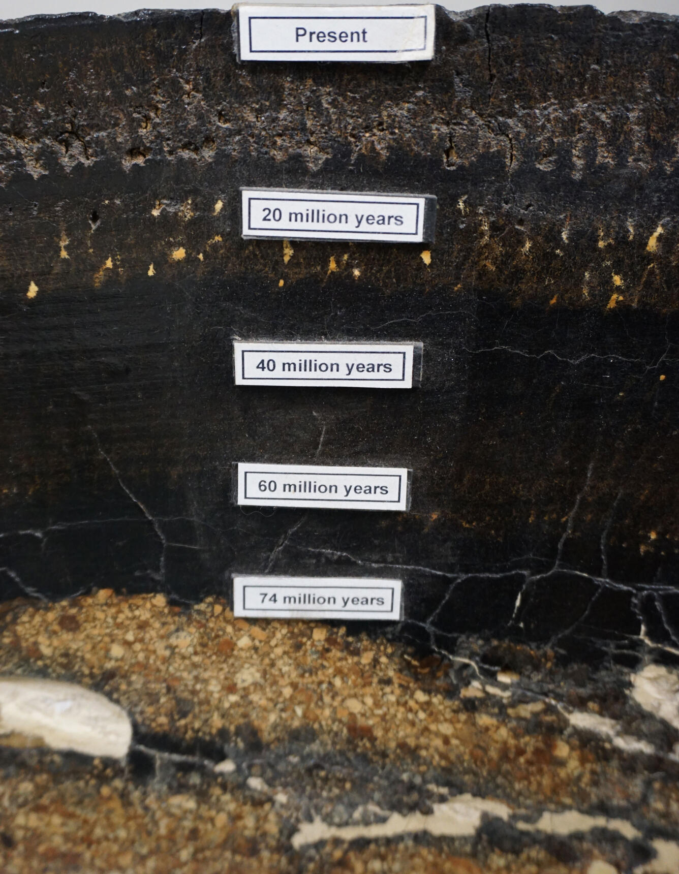
Top of a ferromanganese crust sample collected from 1,896 meters water depth at Necker Ridge in the central north Pacific. The surface of this crust was in contact with ocean water and grew just 2 millimeters per million years.
Top of a ferromanganese crust sample collected from 1,896 meters water depth at Necker Ridge in the central north Pacific. The surface of this crust was in contact with ocean water and grew just 2 millimeters per million years.
About the 2025 List of Critical Minerals
This page contains information about the 2025 List of Critical Minerals, including Frequently Asked Questions, related publications and more.
Seafloor Benthic Mapping and Characterization: Enhancing our Understanding of Aleutian Islands’ Hazards, Potential Seabed Minerals and Deep Corals
A USGS-led expedition in the Aleutian Arc off Alaska will provide critical information on energy resources, underwater earthquakes and other hazards, seafloor habitats, and biological resources, including key fisheries, as well as potential seabed minerals.
By
Ecosystems Mission Area, Natural Hazards Mission Area, Coastal and Marine Hazards and Resources Program, Land Management Research Program, Species Management Research Program, Eastern Ecological Science Center, Pacific Coastal and Marine Science Center, St. Petersburg Coastal and Marine Science Center, Wetland and Aquatic Research Center , Woods Hole Coastal and Marine Science Center, Hawaiian Volcano Observatory, Deep Sea Exploration, Mapping and Characterization
Global Seabed Mineral Resources
The Global Marine Mineral Resources project studies deep ocean minerals that occur within the U.S. Exclusive Economic Zone and areas beyond national jurisdictions. Our research concerns the setting, genesis, and metal enrichment processes of mineral occurrences, the relationship between marine minerals and deep-sea biota, and the potential geochemical footprint of any seafloor mining. We aim to...
Marine Geomorphology, Evolution, and Habitats
Seafloor resource managers and modelers need seafloor maps that can be combined in GIS, modeling, and statistical analysis environments and related successfully to biologic and oceanographic data. The Marine Geomorphology, Evolution, and Habitats Project encompasses mapping activities and the development of new mapping systems and methodologies. The emphasis is on the role of geologic processes in...
Resources: EXPRESS
Along the U.S. west coast, the Pacific Ocean, ocean floor, and winds above contain potentially vast energy and mineral resources. Developing these resources safely and wisely requires detailed information for each area of interest. One goal of EXPRESS is to inform ocean energy and mineral resource decisions.

EXPRESS: Expanding Pacific Research and Exploration of Submerged Systems
EXPRESS is a multi-year, multi-institution cooperative research campaign in deep sea areas of California, Oregon, and Washington, including the continental shelf and slope. EXPRESS data and information are intended to guide wise use of living marine resources and habitats, inform ocean energy and mineral resource decisions, and improve offshore hazard assessments.

California Sand Resource Assessment Project
The USGS is working in partnership with the Bureau of Ocean Energy Management (BOEM) and the State of California Ocean Protection Council (OPC) to evaluate sand and gravel resources in Federal and State waters for potential use in future beach nourishment projects. Prior to the leasing and development of outer continental shelf (OCS) sand resources for use in beach restoration or coastal...

Seabird Vulnerability Assessment for Renewable Energy Projects
In 2017, the Western Ecological Research Center's seabird studies team developed a framework for quantifying seabird species vulnerability to offshore wind energy infrastructure in the Pacific Outer Continental Shelf portion of the California Current region. This tool supports marine resource-use planning by identifying sites where seabirds are most vulnerable and predicts how different species...

Critical Mineral Resources in Heavy Mineral Sands of the U.S. Atlantic Coastal Plain
In many parts of the southeastern U.S., dark-colored sands can be seen at beaches or beneath soil. These sands contain titanium, zirconium, and rare earth elements, which are considered critical mineral resources. Such sands are present in areas from the coast to a hundred miles or more inland beneath soil within the Atlantic Coastal Plain Province. In some locales they are concentrated enough to...

Large Oil Spills
Oil spills, such as the 2010 Deepwater Horizon Oil Spill, are impactful environmental disasters that have long lasting effects to the landscape, native species, and inhabitants who depend on the area. The USGS explores the adverse effect that large-scale oil spills have on the environment and helps responders prepare for environmental recovery and rehabilitation.

U.S. Geological Survey Gas Hydrates Project
The USGS Gas Hydrates Project has been making contributions to advance understanding of US and international gas hydrates science for at least three decades. The research group working on gas hydrates at the USGS is among the largest in the US and has expertise in all the major geoscience disciplines, as well as in the physics and chemistry of gas hydrates, the geotechnical properties of hydrate...

Gulf Coast Geologic Energy Assessments
One of the main goals of the Gulf Coast Geologic Energy Assessments and Research (GEAR) project is to conduct assessments of undiscovered, technically recoverable petroleum resources of the U.S. Gulf Coast region. This goal is in accordance with the Energy Policy and Conservation Act (EPCA) and is performed in collaboration with the USGS National Oil and Gas Assessment project. These high-quality...
Escanaba Trough Expedition: Gravity Coring
Seafloor features such as sulfide mounds and chimneys are prominent evidence of hydrothermal activity. These features, whether active or dormant, are just the tip of the iceberg, so to speak; much of the “plumbing” of hydrothermal systems exists beneath the seafloor surface.
Seafloor features such as sulfide mounds and chimneys are prominent evidence of hydrothermal activity. These features, whether active or dormant, are just the tip of the iceberg, so to speak; much of the “plumbing” of hydrothermal systems exists beneath the seafloor surface.
Escanaba Trough Expedition: Part 2
Critical to scientific operations aboard the Escanaba Trough expedition is the submersible robots Sentry and Jason. Owned and operated by the Woods Hole Oceanographic Institute (WHOI), these robots allow researchers to observe seafloor features and collect data from depths seldom visited by humans.
Critical to scientific operations aboard the Escanaba Trough expedition is the submersible robots Sentry and Jason. Owned and operated by the Woods Hole Oceanographic Institute (WHOI), these robots allow researchers to observe seafloor features and collect data from depths seldom visited by humans.
Escanaba Trough Expedition: Part 3
For scientists aboard the Escanaba Trough expedition, obtaining sediment cores or deep-sea biological and geological samples after a Jason dive is only the beginning.
For scientists aboard the Escanaba Trough expedition, obtaining sediment cores or deep-sea biological and geological samples after a Jason dive is only the beginning.
Escanaba Trough Expedition: Introduction
Embarking on a three-week deep-sea research expedition requires a lot of preparation. For this expedition to Escanaba Trough, U.S. Geological Survey scientists and partners spend the first few days in port, building their laboratory space aboard the research vessel Thomas G. Thompson.
Embarking on a three-week deep-sea research expedition requires a lot of preparation. For this expedition to Escanaba Trough, U.S. Geological Survey scientists and partners spend the first few days in port, building their laboratory space aboard the research vessel Thomas G. Thompson.
Climate Science Champions, Season 2: Kira Mizell, Research Oceanographer
Climate Science Champions, Season 2: Kira Mizell, Research OceanographerResearch Oceanographer Kira Mizell studies change in ocean chemistry by collecting marine minerals, looking for insights into past climate conditions and geologic history.
Ferromanganese Nodules—2021 North Atlantic Stepping Stones Expedition
Ferromanganese Nodules—2021 North Atlantic Stepping Stones ExpeditionDuring a recent dive on the New England Seamount chain off the North Atlantic coast, researchers aboard the NOAA Ocean Exploration Expedition, North Atlantic Stepping Stones, discovered a marine geological feature known as a ferromanganese (Fe-Mn) nodule field in the saddle between two peaks of Gosnold Seamount.
NOAA-USGS Stepping Stones 2021 Expedition
Join USGS researchers Jason Chaytor and Kira Mizell as they virtually participate in a NOAA Ocean Exploration expedition to the depths of the North Atlantic.
Join USGS researchers Jason Chaytor and Kira Mizell as they virtually participate in a NOAA Ocean Exploration expedition to the depths of the North Atlantic.
Offshore oil drilling
Offshore Drilling
Necker Ridge ferromanganese crust
Top of a ferromanganese crust sample collected from 1,896 meters water depth at Necker Ridge in the central north Pacific. The surface of this crust was in contact with ocean water and grew just 2 millimeters per million years.
Top of a ferromanganese crust sample collected from 1,896 meters water depth at Necker Ridge in the central north Pacific. The surface of this crust was in contact with ocean water and grew just 2 millimeters per million years.

Seafloor crust, Marshall Islands
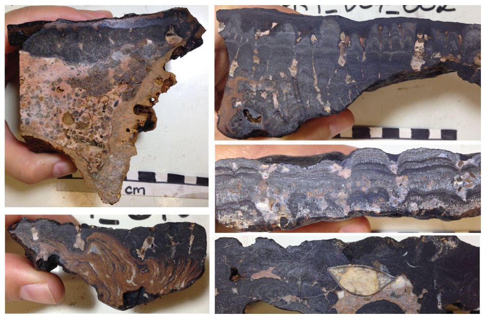
Cross section of a seafloor crust (AKA, ferromanganese or cobalt-rich crusts) from the Marshall Islands collected at almost 2,000 meters depth.
Cross section of a seafloor crust (AKA, ferromanganese or cobalt-rich crusts) from the Marshall Islands collected at almost 2,000 meters depth.

Phosphorite rock
Phosphorite rock formed on the seafloor in Southern California.
Phosphorite rock formed on the seafloor in Southern California.

Bathymetry of the Arctic Ocean, with black outline of study area
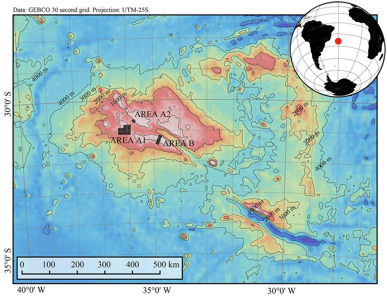
Bathymetry of the Arctic Ocean, with black outline of study areaBathymetry of the Arctic Ocean, with black rectangle delineating the study area. White star marks site where sample in photograph was collected. Its cut surfaces show layers in Fe-Mn crust. Each square in scale beneath sample is 1 centimeter (cm).
Bathymetry of the Arctic Ocean, with black outline of study area
Bathymetry of the Arctic Ocean, with black outline of study areaBathymetry of the Arctic Ocean, with black rectangle delineating the study area. White star marks site where sample in photograph was collected. Its cut surfaces show layers in Fe-Mn crust. Each square in scale beneath sample is 1 centimeter (cm).

Cross section of a hydrothermal vent chimney
Cross section of a hydrothermal vent chimney from East Diamante Caldera in the Mariana volcanic arc, west Pacific Ocean, collected during a 2010 research cruise. Most of the sample is zinc sulfide.
Cross section of a hydrothermal vent chimney from East Diamante Caldera in the Mariana volcanic arc, west Pacific Ocean, collected during a 2010 research cruise. Most of the sample is zinc sulfide.

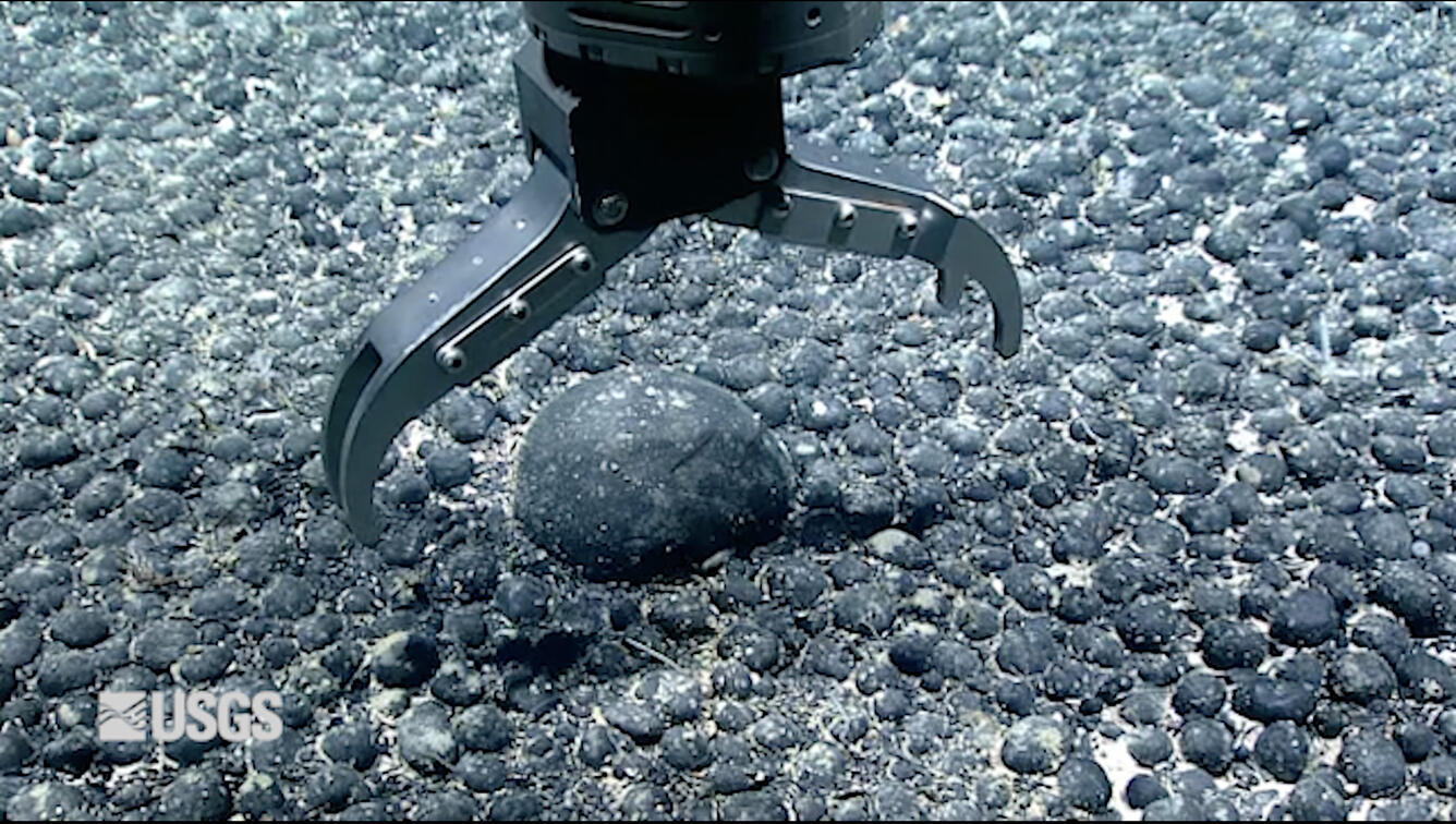
Cook Islands manganese nodules
A bed of manganese nodules from deep offshore of the Cook Islands; photo sourced from Hein et al., 2015, taken during a Japanese research cruise in the year 2000. Nodules range from about 2 to 10 centimeters across.
A bed of manganese nodules from deep offshore of the Cook Islands; photo sourced from Hein et al., 2015, taken during a Japanese research cruise in the year 2000. Nodules range from about 2 to 10 centimeters across.

Manganese nodule
A manganese nodule from the Cook Islands EEZ from Hein et al., 2015.
A manganese nodule from the Cook Islands EEZ from Hein et al., 2015.

Manganese nodules from the Cook Islands EEZ
Manganese nodules from the Cook Islands EEZ, from Hein et al., 2015. Pictured scale bars for A, B, C, D, F, J, K, and L are in cm, and the grid dimensions for E, G, H, and I are 5 × 5 mm;
Manganese nodules from the Cook Islands EEZ, from Hein et al., 2015. Pictured scale bars for A, B, C, D, F, J, K, and L are in cm, and the grid dimensions for E, G, H, and I are 5 × 5 mm;

What is methane and why is it a safety concern? What is methane and why is it a safety concern?
Methane (a gas composed of carbon and hydrogen) is produced two ways: Through biologic decomposition of organic matter at shallow depths. Swamps, landfills, and even shallow bedrock are some settings where this occurs. Methane can also be derived over millions of years by high pressure and high temperature processes that produce fossil fuels deep underground. Examples include coal deposits and oil...

How do the USGS and Bureau of Ocean Energy Management (BOEM) divide up which areas to be assessed for Oil and Gas Resources? How do the USGS and Bureau of Ocean Energy Management (BOEM) divide up which areas to be assessed for Oil and Gas Resources?
The USGS is responsible for oil and gas assessments onshore and in state waters (up to 3 miles offshore), while the Bureau of Ocean Energy Management (BOEM) assesses energy resources in the Federal offshore waters and the outer continental shelf. Learn more: USGS Energy Assessments
Offshore areas hold enormous potential for energy and mineral resources, including oil and gas, wind and wave power, and marine mineral occurrences. The USGS and partners discover, map and assess how these resources can be harnessed sustainably. USGS expertise is also applied to minimize or restore impacts from extraction and spills for the good of the nation.
Each of our nation’s offshore regions host different—yet potentially vast—energy and mineral resources. These resources range from deep-sea minerals, which include elements that are critical to industry and technological applications, to oil, gas, and gas hydrates. Developing offshore resources safely and wisely requires detailed information for each area of interest.
Deep sea minerals
Media
Sources/Usage: Public Domain. View Media Details
Like minerals on land, deep-sea minerals occur in a wide variety of settings related to Earth’s geologic framework and history. Unlike minerals on land, however, deep-sea minerals are less accessible and sometimes poorly understood. USGS is part of a global effort to shed light on the characterization and distribution of these potentially valuable minerals.
Some deep-sea minerals are of potential economic interest due to their composition, which can include critical minerals such as the rare earth elements needed for manufacturing by the technology sector and beyond. USGS investigates how and where these minerals form, what conditions contribute to their growth, how long it takes for them to accumulate, and identify where other similar minerals might occur.
For example, massive sulfide occurrences, which include many important metallic elements, occur in specific regions of the seafloor, including offshore of northern California and Oregon. These mineral mounds and chimneys form when hot water from beneath the ocean floor vents and mixes with cold seawater, creating precipitates that may have high concentrations of copper, zinc, iron, gold, and silver. Sulfide occurrences are characteristic geologic features of volcanic arcs, back arcs, and spreading centers. Volcanic arcs form as a result of subduction zones, where one tectonic plate slides beneath another under great temperatures and pressures. Learn more about Marine Geology.
Understanding these geothermal and geochemical processes allows scientists to determine where deep sea minerals occur and at what rates they accumulate. By characterizing the benthic environment through tectonic fault mapping, seafloor mapping, and habitat classification, USGS assists in evaluating the structural integrity of proposed energy projects and the environmental impacts to seafloor habitats.
The USGS works with multiple partners responsible for decisions about extracting mineral resources from the seabed and provides the science needed to evaluate these resources and activities related to extracting them safely and sustainably.
Sources/Usage: Public Domain. View Media Details
Offshore Energy Development
Media
Sources/Usage: Public Domain. View Media Details
With growing state and national interest in offshore renewable energy development, USGS provides reliable science to inform environmentally sound decisions about managing energy activities, developing mitigation measures, and assessing the potential direct, indirect and cumulative impacts of offshore development on the human, coastal, and marine environments.
There is a critical need for seismic fault mapping, seafloor mapping, understanding of sediment dynamics, and site-characterization information to evaluate the structural integrity of proposed energy projects and the environmental impacts to seafloor habitats. USGS assists other Federal agencies and partners to understand the geology and structure of the seafloor in order to safely install infrastructure to harness offshore energy resources including wind, waves, and oil and gas.
In order to make environmentally sound decisions about managing energy activities and developing mitigation measures, the potential direct, indirect and cumulative impacts of offshore development on the human, coastal, and marine environments must be evaluated. USGS biologists and ecologists work with partners to provide information on potential impacts of offshore energy development on migratory birds, marine mammals, and other offshore species.
Media
Sources/Usage: Public Domain. View Media Details
Science
About the 2025 List of Critical Minerals
This page contains information about the 2025 List of Critical Minerals, including Frequently Asked Questions, related publications and more.
Seafloor Benthic Mapping and Characterization: Enhancing our Understanding of Aleutian Islands’ Hazards, Potential Seabed Minerals and Deep Corals
A USGS-led expedition in the Aleutian Arc off Alaska will provide critical information on energy resources, underwater earthquakes and other hazards, seafloor habitats, and biological resources, including key fisheries, as well as potential seabed minerals.
By
Ecosystems Mission Area, Natural Hazards Mission Area, Coastal and Marine Hazards and Resources Program, Land Management Research Program, Species Management Research Program, Eastern Ecological Science Center, Pacific Coastal and Marine Science Center, St. Petersburg Coastal and Marine Science Center, Wetland and Aquatic Research Center , Woods Hole Coastal and Marine Science Center, Hawaiian Volcano Observatory, Deep Sea Exploration, Mapping and Characterization
Global Seabed Mineral Resources
The Global Marine Mineral Resources project studies deep ocean minerals that occur within the U.S. Exclusive Economic Zone and areas beyond national jurisdictions. Our research concerns the setting, genesis, and metal enrichment processes of mineral occurrences, the relationship between marine minerals and deep-sea biota, and the potential geochemical footprint of any seafloor mining. We aim to...
Marine Geomorphology, Evolution, and Habitats
Seafloor resource managers and modelers need seafloor maps that can be combined in GIS, modeling, and statistical analysis environments and related successfully to biologic and oceanographic data. The Marine Geomorphology, Evolution, and Habitats Project encompasses mapping activities and the development of new mapping systems and methodologies. The emphasis is on the role of geologic processes in...
Resources: EXPRESS
Along the U.S. west coast, the Pacific Ocean, ocean floor, and winds above contain potentially vast energy and mineral resources. Developing these resources safely and wisely requires detailed information for each area of interest. One goal of EXPRESS is to inform ocean energy and mineral resource decisions.
Multimedia
Escanaba Trough Expedition: Gravity Coring
Seafloor features such as sulfide mounds and chimneys are prominent evidence of hydrothermal activity. These features, whether active or dormant, are just the tip of the iceberg, so to speak; much of the “plumbing” of hydrothermal systems exists beneath the seafloor surface.
Seafloor features such as sulfide mounds and chimneys are prominent evidence of hydrothermal activity. These features, whether active or dormant, are just the tip of the iceberg, so to speak; much of the “plumbing” of hydrothermal systems exists beneath the seafloor surface.
Escanaba Trough Expedition: Part 2
Critical to scientific operations aboard the Escanaba Trough expedition is the submersible robots Sentry and Jason. Owned and operated by the Woods Hole Oceanographic Institute (WHOI), these robots allow researchers to observe seafloor features and collect data from depths seldom visited by humans.
Critical to scientific operations aboard the Escanaba Trough expedition is the submersible robots Sentry and Jason. Owned and operated by the Woods Hole Oceanographic Institute (WHOI), these robots allow researchers to observe seafloor features and collect data from depths seldom visited by humans.
Escanaba Trough Expedition: Part 3
For scientists aboard the Escanaba Trough expedition, obtaining sediment cores or deep-sea biological and geological samples after a Jason dive is only the beginning.
For scientists aboard the Escanaba Trough expedition, obtaining sediment cores or deep-sea biological and geological samples after a Jason dive is only the beginning.
Escanaba Trough Expedition: Introduction
Embarking on a three-week deep-sea research expedition requires a lot of preparation. For this expedition to Escanaba Trough, U.S. Geological Survey scientists and partners spend the first few days in port, building their laboratory space aboard the research vessel Thomas G. Thompson.
Embarking on a three-week deep-sea research expedition requires a lot of preparation. For this expedition to Escanaba Trough, U.S. Geological Survey scientists and partners spend the first few days in port, building their laboratory space aboard the research vessel Thomas G. Thompson.
Climate Science Champions, Season 2: Kira Mizell, Research Oceanographer
Climate Science Champions, Season 2: Kira Mizell, Research OceanographerResearch Oceanographer Kira Mizell studies change in ocean chemistry by collecting marine minerals, looking for insights into past climate conditions and geologic history.
Climate Science Champions, Season 2: Kira Mizell, Research Oceanographer
Climate Science Champions, Season 2: Kira Mizell, Research OceanographerResearch Oceanographer Kira Mizell studies change in ocean chemistry by collecting marine minerals, looking for insights into past climate conditions and geologic history.
Ferromanganese Nodules—2021 North Atlantic Stepping Stones Expedition
Ferromanganese Nodules—2021 North Atlantic Stepping Stones ExpeditionDuring a recent dive on the New England Seamount chain off the North Atlantic coast, researchers aboard the NOAA Ocean Exploration Expedition, North Atlantic Stepping Stones, discovered a marine geological feature known as a ferromanganese (Fe-Mn) nodule field in the saddle between two peaks of Gosnold Seamount.
Ferromanganese Nodules—2021 North Atlantic Stepping Stones Expedition
Ferromanganese Nodules—2021 North Atlantic Stepping Stones ExpeditionDuring a recent dive on the New England Seamount chain off the North Atlantic coast, researchers aboard the NOAA Ocean Exploration Expedition, North Atlantic Stepping Stones, discovered a marine geological feature known as a ferromanganese (Fe-Mn) nodule field in the saddle between two peaks of Gosnold Seamount.
NOAA-USGS Stepping Stones 2021 Expedition
Join USGS researchers Jason Chaytor and Kira Mizell as they virtually participate in a NOAA Ocean Exploration expedition to the depths of the North Atlantic.
Join USGS researchers Jason Chaytor and Kira Mizell as they virtually participate in a NOAA Ocean Exploration expedition to the depths of the North Atlantic.
Offshore oil drilling
Offshore Drilling
Necker Ridge ferromanganese crust
Top of a ferromanganese crust sample collected from 1,896 meters water depth at Necker Ridge in the central north Pacific. The surface of this crust was in contact with ocean water and grew just 2 millimeters per million years.
Top of a ferromanganese crust sample collected from 1,896 meters water depth at Necker Ridge in the central north Pacific. The surface of this crust was in contact with ocean water and grew just 2 millimeters per million years.
About the 2025 List of Critical Minerals
This page contains information about the 2025 List of Critical Minerals, including Frequently Asked Questions, related publications and more.
Seafloor Benthic Mapping and Characterization: Enhancing our Understanding of Aleutian Islands’ Hazards, Potential Seabed Minerals and Deep Corals
A USGS-led expedition in the Aleutian Arc off Alaska will provide critical information on energy resources, underwater earthquakes and other hazards, seafloor habitats, and biological resources, including key fisheries, as well as potential seabed minerals.
By
Ecosystems Mission Area, Natural Hazards Mission Area, Coastal and Marine Hazards and Resources Program, Land Management Research Program, Species Management Research Program, Eastern Ecological Science Center, Pacific Coastal and Marine Science Center, St. Petersburg Coastal and Marine Science Center, Wetland and Aquatic Research Center , Woods Hole Coastal and Marine Science Center, Hawaiian Volcano Observatory, Deep Sea Exploration, Mapping and Characterization
Global Seabed Mineral Resources
The Global Marine Mineral Resources project studies deep ocean minerals that occur within the U.S. Exclusive Economic Zone and areas beyond national jurisdictions. Our research concerns the setting, genesis, and metal enrichment processes of mineral occurrences, the relationship between marine minerals and deep-sea biota, and the potential geochemical footprint of any seafloor mining. We aim to...
Marine Geomorphology, Evolution, and Habitats
Seafloor resource managers and modelers need seafloor maps that can be combined in GIS, modeling, and statistical analysis environments and related successfully to biologic and oceanographic data. The Marine Geomorphology, Evolution, and Habitats Project encompasses mapping activities and the development of new mapping systems and methodologies. The emphasis is on the role of geologic processes in...
Resources: EXPRESS
Along the U.S. west coast, the Pacific Ocean, ocean floor, and winds above contain potentially vast energy and mineral resources. Developing these resources safely and wisely requires detailed information for each area of interest. One goal of EXPRESS is to inform ocean energy and mineral resource decisions.
EXPRESS: Expanding Pacific Research and Exploration of Submerged Systems
EXPRESS is a multi-year, multi-institution cooperative research campaign in deep sea areas of California, Oregon, and Washington, including the continental shelf and slope. EXPRESS data and information are intended to guide wise use of living marine resources and habitats, inform ocean energy and mineral resource decisions, and improve offshore hazard assessments.
California Sand Resource Assessment Project
The USGS is working in partnership with the Bureau of Ocean Energy Management (BOEM) and the State of California Ocean Protection Council (OPC) to evaluate sand and gravel resources in Federal and State waters for potential use in future beach nourishment projects. Prior to the leasing and development of outer continental shelf (OCS) sand resources for use in beach restoration or coastal...
Seabird Vulnerability Assessment for Renewable Energy Projects
In 2017, the Western Ecological Research Center's seabird studies team developed a framework for quantifying seabird species vulnerability to offshore wind energy infrastructure in the Pacific Outer Continental Shelf portion of the California Current region. This tool supports marine resource-use planning by identifying sites where seabirds are most vulnerable and predicts how different species...
Critical Mineral Resources in Heavy Mineral Sands of the U.S. Atlantic Coastal Plain
In many parts of the southeastern U.S., dark-colored sands can be seen at beaches or beneath soil. These sands contain titanium, zirconium, and rare earth elements, which are considered critical mineral resources. Such sands are present in areas from the coast to a hundred miles or more inland beneath soil within the Atlantic Coastal Plain Province. In some locales they are concentrated enough to...
Large Oil Spills
Oil spills, such as the 2010 Deepwater Horizon Oil Spill, are impactful environmental disasters that have long lasting effects to the landscape, native species, and inhabitants who depend on the area. The USGS explores the adverse effect that large-scale oil spills have on the environment and helps responders prepare for environmental recovery and rehabilitation.
U.S. Geological Survey Gas Hydrates Project
The USGS Gas Hydrates Project has been making contributions to advance understanding of US and international gas hydrates science for at least three decades. The research group working on gas hydrates at the USGS is among the largest in the US and has expertise in all the major geoscience disciplines, as well as in the physics and chemistry of gas hydrates, the geotechnical properties of hydrate...
Gulf Coast Geologic Energy Assessments
One of the main goals of the Gulf Coast Geologic Energy Assessments and Research (GEAR) project is to conduct assessments of undiscovered, technically recoverable petroleum resources of the U.S. Gulf Coast region. This goal is in accordance with the Energy Policy and Conservation Act (EPCA) and is performed in collaboration with the USGS National Oil and Gas Assessment project. These high-quality...
Escanaba Trough Expedition: Gravity Coring
Seafloor features such as sulfide mounds and chimneys are prominent evidence of hydrothermal activity. These features, whether active or dormant, are just the tip of the iceberg, so to speak; much of the “plumbing” of hydrothermal systems exists beneath the seafloor surface.
Seafloor features such as sulfide mounds and chimneys are prominent evidence of hydrothermal activity. These features, whether active or dormant, are just the tip of the iceberg, so to speak; much of the “plumbing” of hydrothermal systems exists beneath the seafloor surface.
Escanaba Trough Expedition: Part 2
Critical to scientific operations aboard the Escanaba Trough expedition is the submersible robots Sentry and Jason. Owned and operated by the Woods Hole Oceanographic Institute (WHOI), these robots allow researchers to observe seafloor features and collect data from depths seldom visited by humans.
Critical to scientific operations aboard the Escanaba Trough expedition is the submersible robots Sentry and Jason. Owned and operated by the Woods Hole Oceanographic Institute (WHOI), these robots allow researchers to observe seafloor features and collect data from depths seldom visited by humans.
Escanaba Trough Expedition: Part 3
For scientists aboard the Escanaba Trough expedition, obtaining sediment cores or deep-sea biological and geological samples after a Jason dive is only the beginning.
For scientists aboard the Escanaba Trough expedition, obtaining sediment cores or deep-sea biological and geological samples after a Jason dive is only the beginning.
Escanaba Trough Expedition: Introduction
Embarking on a three-week deep-sea research expedition requires a lot of preparation. For this expedition to Escanaba Trough, U.S. Geological Survey scientists and partners spend the first few days in port, building their laboratory space aboard the research vessel Thomas G. Thompson.
Embarking on a three-week deep-sea research expedition requires a lot of preparation. For this expedition to Escanaba Trough, U.S. Geological Survey scientists and partners spend the first few days in port, building their laboratory space aboard the research vessel Thomas G. Thompson.
Climate Science Champions, Season 2: Kira Mizell, Research Oceanographer
Climate Science Champions, Season 2: Kira Mizell, Research OceanographerResearch Oceanographer Kira Mizell studies change in ocean chemistry by collecting marine minerals, looking for insights into past climate conditions and geologic history.
Climate Science Champions, Season 2: Kira Mizell, Research Oceanographer
Climate Science Champions, Season 2: Kira Mizell, Research OceanographerResearch Oceanographer Kira Mizell studies change in ocean chemistry by collecting marine minerals, looking for insights into past climate conditions and geologic history.
Ferromanganese Nodules—2021 North Atlantic Stepping Stones Expedition
Ferromanganese Nodules—2021 North Atlantic Stepping Stones ExpeditionDuring a recent dive on the New England Seamount chain off the North Atlantic coast, researchers aboard the NOAA Ocean Exploration Expedition, North Atlantic Stepping Stones, discovered a marine geological feature known as a ferromanganese (Fe-Mn) nodule field in the saddle between two peaks of Gosnold Seamount.
Ferromanganese Nodules—2021 North Atlantic Stepping Stones Expedition
Ferromanganese Nodules—2021 North Atlantic Stepping Stones ExpeditionDuring a recent dive on the New England Seamount chain off the North Atlantic coast, researchers aboard the NOAA Ocean Exploration Expedition, North Atlantic Stepping Stones, discovered a marine geological feature known as a ferromanganese (Fe-Mn) nodule field in the saddle between two peaks of Gosnold Seamount.
NOAA-USGS Stepping Stones 2021 Expedition
Join USGS researchers Jason Chaytor and Kira Mizell as they virtually participate in a NOAA Ocean Exploration expedition to the depths of the North Atlantic.
Join USGS researchers Jason Chaytor and Kira Mizell as they virtually participate in a NOAA Ocean Exploration expedition to the depths of the North Atlantic.
Offshore oil drilling
Offshore Drilling
Necker Ridge ferromanganese crust
Top of a ferromanganese crust sample collected from 1,896 meters water depth at Necker Ridge in the central north Pacific. The surface of this crust was in contact with ocean water and grew just 2 millimeters per million years.
Top of a ferromanganese crust sample collected from 1,896 meters water depth at Necker Ridge in the central north Pacific. The surface of this crust was in contact with ocean water and grew just 2 millimeters per million years.
Seafloor crust, Marshall Islands
Cross section of a seafloor crust (AKA, ferromanganese or cobalt-rich crusts) from the Marshall Islands collected at almost 2,000 meters depth.
Cross section of a seafloor crust (AKA, ferromanganese or cobalt-rich crusts) from the Marshall Islands collected at almost 2,000 meters depth.
Phosphorite rock
Phosphorite rock formed on the seafloor in Southern California.
Phosphorite rock formed on the seafloor in Southern California.
Bathymetry of the Arctic Ocean, with black outline of study area
Bathymetry of the Arctic Ocean, with black outline of study areaBathymetry of the Arctic Ocean, with black rectangle delineating the study area. White star marks site where sample in photograph was collected. Its cut surfaces show layers in Fe-Mn crust. Each square in scale beneath sample is 1 centimeter (cm).
Cross section of a hydrothermal vent chimney
Cross section of a hydrothermal vent chimney from East Diamante Caldera in the Mariana volcanic arc, west Pacific Ocean, collected during a 2010 research cruise. Most of the sample is zinc sulfide.
Cross section of a hydrothermal vent chimney from East Diamante Caldera in the Mariana volcanic arc, west Pacific Ocean, collected during a 2010 research cruise. Most of the sample is zinc sulfide.
Cook Islands manganese nodules
A bed of manganese nodules from deep offshore of the Cook Islands; photo sourced from Hein et al., 2015, taken during a Japanese research cruise in the year 2000. Nodules range from about 2 to 10 centimeters across.
A bed of manganese nodules from deep offshore of the Cook Islands; photo sourced from Hein et al., 2015, taken during a Japanese research cruise in the year 2000. Nodules range from about 2 to 10 centimeters across.
Manganese nodule
A manganese nodule from the Cook Islands EEZ from Hein et al., 2015.
A manganese nodule from the Cook Islands EEZ from Hein et al., 2015.
Manganese nodules from the Cook Islands EEZ
Manganese nodules from the Cook Islands EEZ, from Hein et al., 2015. Pictured scale bars for A, B, C, D, F, J, K, and L are in cm, and the grid dimensions for E, G, H, and I are 5 × 5 mm;
Manganese nodules from the Cook Islands EEZ, from Hein et al., 2015. Pictured scale bars for A, B, C, D, F, J, K, and L are in cm, and the grid dimensions for E, G, H, and I are 5 × 5 mm;
What is methane and why is it a safety concern? What is methane and why is it a safety concern?
Methane (a gas composed of carbon and hydrogen) is produced two ways: Through biologic decomposition of organic matter at shallow depths. Swamps, landfills, and even shallow bedrock are some settings where this occurs. Methane can also be derived over millions of years by high pressure and high temperature processes that produce fossil fuels deep underground. Examples include coal deposits and oil...
How do the USGS and Bureau of Ocean Energy Management (BOEM) divide up which areas to be assessed for Oil and Gas Resources? How do the USGS and Bureau of Ocean Energy Management (BOEM) divide up which areas to be assessed for Oil and Gas Resources?
The USGS is responsible for oil and gas assessments onshore and in state waters (up to 3 miles offshore), while the Bureau of Ocean Energy Management (BOEM) assesses energy resources in the Federal offshore waters and the outer continental shelf. Learn more: USGS Energy Assessments