



U.S. Geological Survey and National Park Service personnel stand with drone technologies used for mapping the Abó Ruins at Salinas Pueblo Missions National Monument in Mountainair, New Mexico.
New Article: Drone-based radiometric surveys provide high-resolution mine waste characterization
New research article: evaluating radiometric calibration and data quality of spectral UAS sensors
Using uncrewed aircraft systems to assess landslide damage after Hurricane Helene
UAS 3D Model of Marsh-Felch Quarry in Colorado
UAS Hyperspectral Imaging during the Missouri River Dye-Trace Study
UAS 3D Scan of the Perry’s Victory and International Peace Memorial
The U.S. Geological Survey (USGS) National Uncrewed Systems Office (NUSO) leads the research activities needed to make Uncrewed Aircraft Systems (UAS) data collection an efficient, safe, and cost-effective remote sensing tool for Department of the Interior (DOI) and USGS scientists.
Technology Research
Technology Research
Research Missions
Research Missions
New and Noteworthy
November 1, 2025
Drone-based radiometric surveys provide high-resolution mine waste characterization
What We Do
Media

Sources/Usage: Public Domain. View Media Details
We focus on the evaluation of new platforms, integration of new UAS-compatible sensors, development of data specifications and processing techniques, recommendations of UAS data acquisition best-practices, and operational support for new and existing DOI remote pilots.
Who We Are
Media

Sources/Usage: Public Domain. View Media Details
We are a team of platform and UAS-compatible sensor subject matter experts that, in addition to research, provide operational support to DOI remote pilots and outreach to federal, public, and international audiences. Our office, established on May 8th, 2008, operates as part of the National Land Imaging Program, and contributes to its goal to provide the Federal Government and the public with the remotely sensed data and applications needed to support our Nation’s economic security and environmental vitality.
Filter Total Items: 125
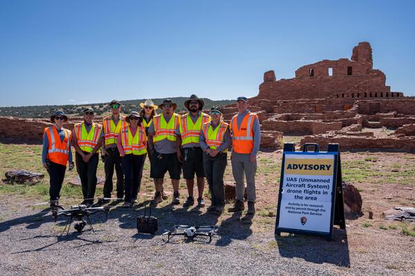
Mapping the Abó Ruins
U.S. Geological Survey and National Park Service personnel stand with drone technologies used for mapping the Abó Ruins at Salinas Pueblo Missions National Monument in Mountainair, New Mexico.
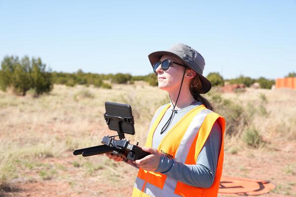
Uncrewed aircraft system (UAS) remote pilot Victoria Scholl
Uncrewed aircraft system (UAS) remote pilot Victoria SchollU.S. Geological Survey remote pilot Victoria Scholl flies a drone with camera payload to capture natural color images for photogrammetric mapping of the Abó Ruins at Salinas Pueblo Missions National Monument in Mountainair, New Mexico.
Uncrewed aircraft system (UAS) remote pilot Victoria Scholl
Uncrewed aircraft system (UAS) remote pilot Victoria SchollU.S. Geological Survey remote pilot Victoria Scholl flies a drone with camera payload to capture natural color images for photogrammetric mapping of the Abó Ruins at Salinas Pueblo Missions National Monument in Mountainair, New Mexico.
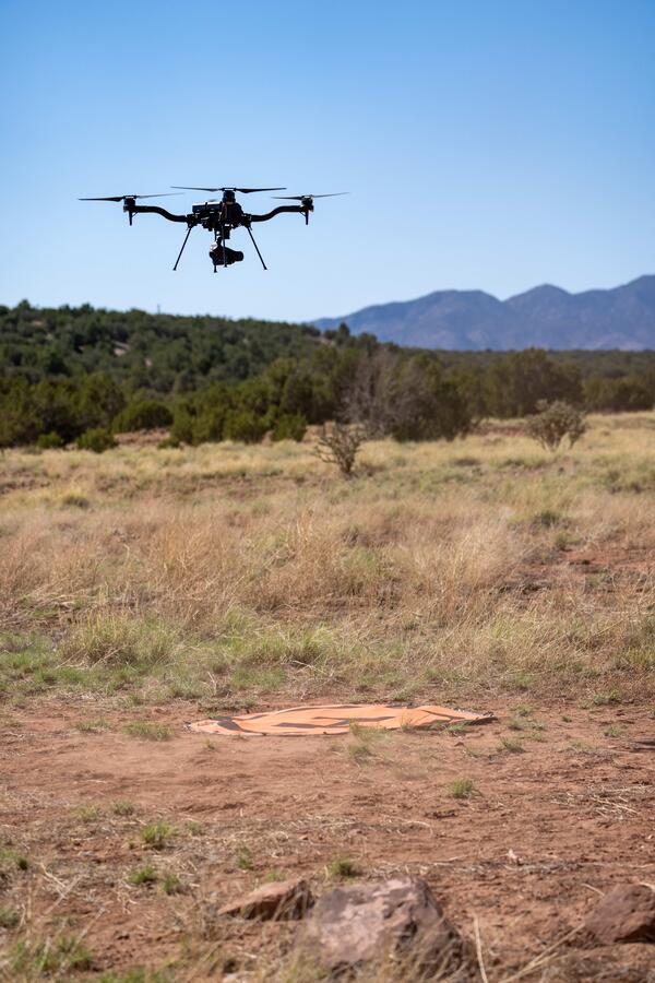
Using uncrewed aircraft systems (UAS) to map Abó Ruins
Using uncrewed aircraft systems (UAS) to map Abó RuinsThe U.S. Geological Survey National Uncrewed Systems Office flew uncrewed aircraft systems (UAS) to map the Abó Ruins at Salinas Pueblo Missions National Monument in Mountainair, New Mexico.
Using uncrewed aircraft systems (UAS) to map Abó Ruins
Using uncrewed aircraft systems (UAS) to map Abó RuinsThe U.S. Geological Survey National Uncrewed Systems Office flew uncrewed aircraft systems (UAS) to map the Abó Ruins at Salinas Pueblo Missions National Monument in Mountainair, New Mexico.
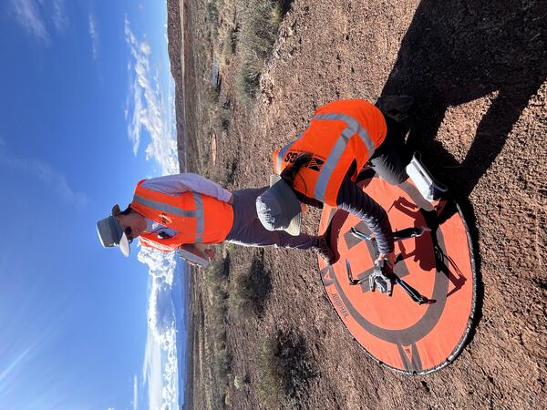
Setting up equipment for drone mapping flight near Moab, Utah
Setting up equipment for drone mapping flight near Moab, UtahUSGS remote pilots Matt Burgess and Victoria Scholl prepare to conduct a drone mapping flight to collect thermal imagery over a dryland study site near Moab, Utah.
Setting up equipment for drone mapping flight near Moab, Utah
Setting up equipment for drone mapping flight near Moab, UtahUSGS remote pilots Matt Burgess and Victoria Scholl prepare to conduct a drone mapping flight to collect thermal imagery over a dryland study site near Moab, Utah.
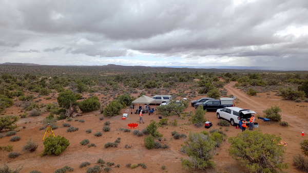
Uncrewed Aircraft Systems fieldwork site in Moab, Utah
Uncrewed Aircraft Systems fieldwork site in Moab, UtahDrone operations near Moab, Utah to collect spectral remote sensing imagery during a collaborative USGS field campaign in May 2025.
Uncrewed Aircraft Systems fieldwork site in Moab, Utah
Uncrewed Aircraft Systems fieldwork site in Moab, UtahDrone operations near Moab, Utah to collect spectral remote sensing imagery during a collaborative USGS field campaign in May 2025.

Lidar point cloud both with and without vegetation-classified points
Lidar point cloud both with and without vegetation-classified pointsIn 2024, the U.S. Geological Survey (USGS) National Uncrewed Systems Office (NUSO) provided technical support to the National Park Service in assessing road damage and landslide hazards along the Blue Ridge Parkway following Hurricane Helene.
Lidar point cloud both with and without vegetation-classified points
Lidar point cloud both with and without vegetation-classified pointsIn 2024, the U.S. Geological Survey (USGS) National Uncrewed Systems Office (NUSO) provided technical support to the National Park Service in assessing road damage and landslide hazards along the Blue Ridge Parkway following Hurricane Helene.

Bare-earth digital terrain model of landslide damaged road
Bare-earth digital terrain model of landslide damaged roadIn 2024, the U.S. Geological Survey (USGS) National Uncrewed Systems Office (NUSO) provided technical support to the National Park Service in assessing road damage and landslide hazards along the Blue Ridge Parkway following Hurricane Helene.
Bare-earth digital terrain model of landslide damaged road
Bare-earth digital terrain model of landslide damaged roadIn 2024, the U.S. Geological Survey (USGS) National Uncrewed Systems Office (NUSO) provided technical support to the National Park Service in assessing road damage and landslide hazards along the Blue Ridge Parkway following Hurricane Helene.

Bare-earth digital terrain model of road damaged by landslide
Bare-earth digital terrain model of road damaged by landslideIn 2024, the U.S. Geological Survey (USGS) National Uncrewed Systems Office (NUSO) provided technical support for the National Park Service in assessing road damage and landslide hazards along the Blue Ridge Parkway following Hurricane Helene.
Bare-earth digital terrain model of road damaged by landslide
Bare-earth digital terrain model of road damaged by landslideIn 2024, the U.S. Geological Survey (USGS) National Uncrewed Systems Office (NUSO) provided technical support for the National Park Service in assessing road damage and landslide hazards along the Blue Ridge Parkway following Hurricane Helene.

Point cloud image of landslide
In 2024, the U.S. Geological Survey (USGS) National Uncrewed Systems Office (NUSO) provided technical support for the National Park Service to assess road damage and landslide hazards after Hurricane Helene along the Blue Ridge Parkway.
In 2024, the U.S. Geological Survey (USGS) National Uncrewed Systems Office (NUSO) provided technical support for the National Park Service to assess road damage and landslide hazards after Hurricane Helene along the Blue Ridge Parkway.
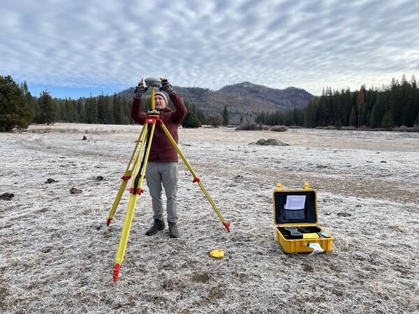
Setting up Global Navigation Satellite System (GNSS) base station in Yosemite
Setting up Global Navigation Satellite System (GNSS) base station in YosemiteUSGS geographer and remote pilot Mark Bauer sets up a Global Navigation Satellite System (GNSS) base station, which will be used to correct uncrewed aircraft system (UAS) lidar data during post-processing. It's early during the field day and a layer of frost covers the ground.
Setting up Global Navigation Satellite System (GNSS) base station in Yosemite
Setting up Global Navigation Satellite System (GNSS) base station in YosemiteUSGS geographer and remote pilot Mark Bauer sets up a Global Navigation Satellite System (GNSS) base station, which will be used to correct uncrewed aircraft system (UAS) lidar data during post-processing. It's early during the field day and a layer of frost covers the ground.

Assessing road damage caused by Hurricane Helene
The U.S. Geological Survey (USGS) employs a range of drone technologies for data collection in science, mapping, and monitoring.
The U.S. Geological Survey (USGS) employs a range of drone technologies for data collection in science, mapping, and monitoring.

Uncrewed aircraft pilots at the Tanbark Ridge Overlook
Uncrewed aircraft pilots at the Tanbark Ridge OverlookU.S. Geological Survey (USGS) remote pilots Joe Adams and Matthew Burgess prepare to conduct drone flights at the Tanbark Ridge Overlook along the Blue Ridge Parkway in North Carolina.
Uncrewed aircraft pilots at the Tanbark Ridge Overlook
Uncrewed aircraft pilots at the Tanbark Ridge OverlookU.S. Geological Survey (USGS) remote pilots Joe Adams and Matthew Burgess prepare to conduct drone flights at the Tanbark Ridge Overlook along the Blue Ridge Parkway in North Carolina.

Using uncrewed aircraft in landslide assessment
The Blue Ridge Parkway is renowned for its winding path through the rugged Appalachian Mountains. The steep terrain and dense forests make for scenic views but also create a challenging environment for drone operations. U.S. Geological Survey (USGS) remote pilots seek out open areas from which to conduct flights to enable good visibility of their surroundings.
The Blue Ridge Parkway is renowned for its winding path through the rugged Appalachian Mountains. The steep terrain and dense forests make for scenic views but also create a challenging environment for drone operations. U.S. Geological Survey (USGS) remote pilots seek out open areas from which to conduct flights to enable good visibility of their surroundings.

Preparing to assess road damage using a drone
In September 2024, Hurricane Helene brought heavy rain and powerful winds, resulting in multiple landslides along the iconic Blue Ridge Parkway. The National Park Service requested technical assistance from the U.S.
In September 2024, Hurricane Helene brought heavy rain and powerful winds, resulting in multiple landslides along the iconic Blue Ridge Parkway. The National Park Service requested technical assistance from the U.S.

Road damaged by landslide
In September 2024, Hurricane Helene brought heavy rain and powerful winds, resulting in multiple landslides along the iconic Blue Ridge Parkway. The National Park Service requested technical assistance from the U.S.
In September 2024, Hurricane Helene brought heavy rain and powerful winds, resulting in multiple landslides along the iconic Blue Ridge Parkway. The National Park Service requested technical assistance from the U.S.

NUSO researchers prepare for evaluation flights with a vertical take-off and landing UAS
NUSO researchers prepare for evaluation flights with a vertical take-off and landing UASNUSO researchers Matt Burgess and Mark Bauer prepare for evaluation flights with the WingtraOne GEN II vertical take-off and landing mapping UAS equipped with the newly released lidar payload.
NUSO researchers prepare for evaluation flights with a vertical take-off and landing UAS
NUSO researchers prepare for evaluation flights with a vertical take-off and landing UASNUSO researchers Matt Burgess and Mark Bauer prepare for evaluation flights with the WingtraOne GEN II vertical take-off and landing mapping UAS equipped with the newly released lidar payload.

Group photo captured using a drone standing at the overlook for the Marsh-Felch quarry.
Group photo captured using a drone standing at the overlook for the Marsh-Felch quarry.Group photo captured using a drone. Left to right: Matt Burgess (NUSO), Paco Van Sistine (GECSC), Victoria Scholl (NUSO) standing at the overlook for the Marsh-Felch quarry.
Group photo captured using a drone standing at the overlook for the Marsh-Felch quarry.
Group photo captured using a drone standing at the overlook for the Marsh-Felch quarry.Group photo captured using a drone. Left to right: Matt Burgess (NUSO), Paco Van Sistine (GECSC), Victoria Scholl (NUSO) standing at the overlook for the Marsh-Felch quarry.

USGS personnel standing at the overlook to the quarry prior to conducting UAS operations.
USGS personnel standing at the overlook to the quarry prior to conducting UAS operations.USGS personnel standing at the overlook to the quarry prior to conducting UAS operations.
Thomas Casadevall (Scientist Emeritus with the Geology, Geophysics, and Geochemistry Science Center), Paco Van Sistine (GECSC), Victoria Scholl (NUSO), Matt Burgess (NUSO)
USGS personnel standing at the overlook to the quarry prior to conducting UAS operations.
USGS personnel standing at the overlook to the quarry prior to conducting UAS operations.USGS personnel standing at the overlook to the quarry prior to conducting UAS operations.
Thomas Casadevall (Scientist Emeritus with the Geology, Geophysics, and Geochemistry Science Center), Paco Van Sistine (GECSC), Victoria Scholl (NUSO), Matt Burgess (NUSO)

Field crew standing at the upper overlook on the Marsh-Felch Quarry site.
Field crew standing at the upper overlook on the Marsh-Felch Quarry site.Field crew standing at the upper overlook on the Marsh-Felch Quarry site.
Field crew standing at the upper overlook on the Marsh-Felch Quarry site.
Field crew standing at the upper overlook on the Marsh-Felch Quarry site.Field crew standing at the upper overlook on the Marsh-Felch Quarry site.

Victoria Scholl (NUSO) conducts a UAS flight at the Marsh-Felch Quarry site.
Victoria Scholl (NUSO) conducts a UAS flight at the Marsh-Felch Quarry site.Victoria Scholl (NUSO) conducts a Skydio X10 UAS 3D Scan flight at the
Marsh-Felch Quarry site.
Victoria Scholl (NUSO) conducts a UAS flight at the Marsh-Felch Quarry site.
Victoria Scholl (NUSO) conducts a UAS flight at the Marsh-Felch Quarry site.Victoria Scholl (NUSO) conducts a Skydio X10 UAS 3D Scan flight at the
Marsh-Felch Quarry site.

USGS geologists view the informational sign at the quarry upper overlook in July 2024.
USGS geologists view the informational sign at the quarry upper overlook in July 2024.USGS geologists view the informational sign at the quarry upper overlook in July 2024. The sign describes the history of Professor O.C. Marsh and Marshall P. Felch, the namesakes of the quarry, who worked together to excavate and study dinosaur bones. The sign features a photograph by Israel Cook Russel, a USGS Geologist, in July 1888.
USGS geologists view the informational sign at the quarry upper overlook in July 2024.
USGS geologists view the informational sign at the quarry upper overlook in July 2024.USGS geologists view the informational sign at the quarry upper overlook in July 2024. The sign describes the history of Professor O.C. Marsh and Marshall P. Felch, the namesakes of the quarry, who worked together to excavate and study dinosaur bones. The sign features a photograph by Israel Cook Russel, a USGS Geologist, in July 1888.
The U.S. Geological Survey (USGS) National Uncrewed Systems Office (NUSO) leads the research activities needed to make Uncrewed Aircraft Systems (UAS) data collection an efficient, safe, and cost-effective remote sensing tool for Department of the Interior (DOI) and USGS scientists.
Technology Research
Technology Research
Research Missions
Research Missions
New and Noteworthy
November 1, 2025
Drone-based radiometric surveys provide high-resolution mine waste characterization
What We Do
Media
Sources/Usage: Public Domain. View Media Details
We focus on the evaluation of new platforms, integration of new UAS-compatible sensors, development of data specifications and processing techniques, recommendations of UAS data acquisition best-practices, and operational support for new and existing DOI remote pilots.
Who We Are
Media
Sources/Usage: Public Domain. View Media Details
We are a team of platform and UAS-compatible sensor subject matter experts that, in addition to research, provide operational support to DOI remote pilots and outreach to federal, public, and international audiences. Our office, established on May 8th, 2008, operates as part of the National Land Imaging Program, and contributes to its goal to provide the Federal Government and the public with the remotely sensed data and applications needed to support our Nation’s economic security and environmental vitality.
Filter Total Items: 125
Mapping the Abó Ruins
U.S. Geological Survey and National Park Service personnel stand with drone technologies used for mapping the Abó Ruins at Salinas Pueblo Missions National Monument in Mountainair, New Mexico.
U.S. Geological Survey and National Park Service personnel stand with drone technologies used for mapping the Abó Ruins at Salinas Pueblo Missions National Monument in Mountainair, New Mexico.
Uncrewed aircraft system (UAS) remote pilot Victoria Scholl
Uncrewed aircraft system (UAS) remote pilot Victoria SchollU.S. Geological Survey remote pilot Victoria Scholl flies a drone with camera payload to capture natural color images for photogrammetric mapping of the Abó Ruins at Salinas Pueblo Missions National Monument in Mountainair, New Mexico.
Uncrewed aircraft system (UAS) remote pilot Victoria Scholl
Uncrewed aircraft system (UAS) remote pilot Victoria SchollU.S. Geological Survey remote pilot Victoria Scholl flies a drone with camera payload to capture natural color images for photogrammetric mapping of the Abó Ruins at Salinas Pueblo Missions National Monument in Mountainair, New Mexico.
Using uncrewed aircraft systems (UAS) to map Abó Ruins
Using uncrewed aircraft systems (UAS) to map Abó RuinsThe U.S. Geological Survey National Uncrewed Systems Office flew uncrewed aircraft systems (UAS) to map the Abó Ruins at Salinas Pueblo Missions National Monument in Mountainair, New Mexico.
Using uncrewed aircraft systems (UAS) to map Abó Ruins
Using uncrewed aircraft systems (UAS) to map Abó RuinsThe U.S. Geological Survey National Uncrewed Systems Office flew uncrewed aircraft systems (UAS) to map the Abó Ruins at Salinas Pueblo Missions National Monument in Mountainair, New Mexico.
Setting up equipment for drone mapping flight near Moab, Utah
Setting up equipment for drone mapping flight near Moab, UtahUSGS remote pilots Matt Burgess and Victoria Scholl prepare to conduct a drone mapping flight to collect thermal imagery over a dryland study site near Moab, Utah.
Setting up equipment for drone mapping flight near Moab, Utah
Setting up equipment for drone mapping flight near Moab, UtahUSGS remote pilots Matt Burgess and Victoria Scholl prepare to conduct a drone mapping flight to collect thermal imagery over a dryland study site near Moab, Utah.
Uncrewed Aircraft Systems fieldwork site in Moab, Utah
Uncrewed Aircraft Systems fieldwork site in Moab, UtahDrone operations near Moab, Utah to collect spectral remote sensing imagery during a collaborative USGS field campaign in May 2025.
Uncrewed Aircraft Systems fieldwork site in Moab, Utah
Uncrewed Aircraft Systems fieldwork site in Moab, UtahDrone operations near Moab, Utah to collect spectral remote sensing imagery during a collaborative USGS field campaign in May 2025.
Lidar point cloud both with and without vegetation-classified points
Lidar point cloud both with and without vegetation-classified pointsIn 2024, the U.S. Geological Survey (USGS) National Uncrewed Systems Office (NUSO) provided technical support to the National Park Service in assessing road damage and landslide hazards along the Blue Ridge Parkway following Hurricane Helene.
Lidar point cloud both with and without vegetation-classified points
Lidar point cloud both with and without vegetation-classified pointsIn 2024, the U.S. Geological Survey (USGS) National Uncrewed Systems Office (NUSO) provided technical support to the National Park Service in assessing road damage and landslide hazards along the Blue Ridge Parkway following Hurricane Helene.
Bare-earth digital terrain model of landslide damaged road
Bare-earth digital terrain model of landslide damaged roadIn 2024, the U.S. Geological Survey (USGS) National Uncrewed Systems Office (NUSO) provided technical support to the National Park Service in assessing road damage and landslide hazards along the Blue Ridge Parkway following Hurricane Helene.
Bare-earth digital terrain model of landslide damaged road
Bare-earth digital terrain model of landslide damaged roadIn 2024, the U.S. Geological Survey (USGS) National Uncrewed Systems Office (NUSO) provided technical support to the National Park Service in assessing road damage and landslide hazards along the Blue Ridge Parkway following Hurricane Helene.
Bare-earth digital terrain model of road damaged by landslide
Bare-earth digital terrain model of road damaged by landslideIn 2024, the U.S. Geological Survey (USGS) National Uncrewed Systems Office (NUSO) provided technical support for the National Park Service in assessing road damage and landslide hazards along the Blue Ridge Parkway following Hurricane Helene.
Bare-earth digital terrain model of road damaged by landslide
Bare-earth digital terrain model of road damaged by landslideIn 2024, the U.S. Geological Survey (USGS) National Uncrewed Systems Office (NUSO) provided technical support for the National Park Service in assessing road damage and landslide hazards along the Blue Ridge Parkway following Hurricane Helene.
Point cloud image of landslide
In 2024, the U.S. Geological Survey (USGS) National Uncrewed Systems Office (NUSO) provided technical support for the National Park Service to assess road damage and landslide hazards after Hurricane Helene along the Blue Ridge Parkway.
In 2024, the U.S. Geological Survey (USGS) National Uncrewed Systems Office (NUSO) provided technical support for the National Park Service to assess road damage and landslide hazards after Hurricane Helene along the Blue Ridge Parkway.
Setting up Global Navigation Satellite System (GNSS) base station in Yosemite
Setting up Global Navigation Satellite System (GNSS) base station in YosemiteUSGS geographer and remote pilot Mark Bauer sets up a Global Navigation Satellite System (GNSS) base station, which will be used to correct uncrewed aircraft system (UAS) lidar data during post-processing. It's early during the field day and a layer of frost covers the ground.
Setting up Global Navigation Satellite System (GNSS) base station in Yosemite
Setting up Global Navigation Satellite System (GNSS) base station in YosemiteUSGS geographer and remote pilot Mark Bauer sets up a Global Navigation Satellite System (GNSS) base station, which will be used to correct uncrewed aircraft system (UAS) lidar data during post-processing. It's early during the field day and a layer of frost covers the ground.
Assessing road damage caused by Hurricane Helene
The U.S. Geological Survey (USGS) employs a range of drone technologies for data collection in science, mapping, and monitoring.
The U.S. Geological Survey (USGS) employs a range of drone technologies for data collection in science, mapping, and monitoring.
Uncrewed aircraft pilots at the Tanbark Ridge Overlook
Uncrewed aircraft pilots at the Tanbark Ridge OverlookU.S. Geological Survey (USGS) remote pilots Joe Adams and Matthew Burgess prepare to conduct drone flights at the Tanbark Ridge Overlook along the Blue Ridge Parkway in North Carolina.
Uncrewed aircraft pilots at the Tanbark Ridge Overlook
Uncrewed aircraft pilots at the Tanbark Ridge OverlookU.S. Geological Survey (USGS) remote pilots Joe Adams and Matthew Burgess prepare to conduct drone flights at the Tanbark Ridge Overlook along the Blue Ridge Parkway in North Carolina.
Using uncrewed aircraft in landslide assessment
The Blue Ridge Parkway is renowned for its winding path through the rugged Appalachian Mountains. The steep terrain and dense forests make for scenic views but also create a challenging environment for drone operations. U.S. Geological Survey (USGS) remote pilots seek out open areas from which to conduct flights to enable good visibility of their surroundings.
The Blue Ridge Parkway is renowned for its winding path through the rugged Appalachian Mountains. The steep terrain and dense forests make for scenic views but also create a challenging environment for drone operations. U.S. Geological Survey (USGS) remote pilots seek out open areas from which to conduct flights to enable good visibility of their surroundings.
Preparing to assess road damage using a drone
In September 2024, Hurricane Helene brought heavy rain and powerful winds, resulting in multiple landslides along the iconic Blue Ridge Parkway. The National Park Service requested technical assistance from the U.S.
In September 2024, Hurricane Helene brought heavy rain and powerful winds, resulting in multiple landslides along the iconic Blue Ridge Parkway. The National Park Service requested technical assistance from the U.S.
Road damaged by landslide
In September 2024, Hurricane Helene brought heavy rain and powerful winds, resulting in multiple landslides along the iconic Blue Ridge Parkway. The National Park Service requested technical assistance from the U.S.
In September 2024, Hurricane Helene brought heavy rain and powerful winds, resulting in multiple landslides along the iconic Blue Ridge Parkway. The National Park Service requested technical assistance from the U.S.
NUSO researchers prepare for evaluation flights with a vertical take-off and landing UAS
NUSO researchers prepare for evaluation flights with a vertical take-off and landing UASNUSO researchers Matt Burgess and Mark Bauer prepare for evaluation flights with the WingtraOne GEN II vertical take-off and landing mapping UAS equipped with the newly released lidar payload.
NUSO researchers prepare for evaluation flights with a vertical take-off and landing UAS
NUSO researchers prepare for evaluation flights with a vertical take-off and landing UASNUSO researchers Matt Burgess and Mark Bauer prepare for evaluation flights with the WingtraOne GEN II vertical take-off and landing mapping UAS equipped with the newly released lidar payload.
Group photo captured using a drone standing at the overlook for the Marsh-Felch quarry.
Group photo captured using a drone standing at the overlook for the Marsh-Felch quarry.Group photo captured using a drone. Left to right: Matt Burgess (NUSO), Paco Van Sistine (GECSC), Victoria Scholl (NUSO) standing at the overlook for the Marsh-Felch quarry.
Group photo captured using a drone standing at the overlook for the Marsh-Felch quarry.
Group photo captured using a drone standing at the overlook for the Marsh-Felch quarry.Group photo captured using a drone. Left to right: Matt Burgess (NUSO), Paco Van Sistine (GECSC), Victoria Scholl (NUSO) standing at the overlook for the Marsh-Felch quarry.
USGS personnel standing at the overlook to the quarry prior to conducting UAS operations.
USGS personnel standing at the overlook to the quarry prior to conducting UAS operations.USGS personnel standing at the overlook to the quarry prior to conducting UAS operations.
Thomas Casadevall (Scientist Emeritus with the Geology, Geophysics, and Geochemistry Science Center), Paco Van Sistine (GECSC), Victoria Scholl (NUSO), Matt Burgess (NUSO)
USGS personnel standing at the overlook to the quarry prior to conducting UAS operations.
USGS personnel standing at the overlook to the quarry prior to conducting UAS operations.USGS personnel standing at the overlook to the quarry prior to conducting UAS operations.
Thomas Casadevall (Scientist Emeritus with the Geology, Geophysics, and Geochemistry Science Center), Paco Van Sistine (GECSC), Victoria Scholl (NUSO), Matt Burgess (NUSO)
Field crew standing at the upper overlook on the Marsh-Felch Quarry site.
Field crew standing at the upper overlook on the Marsh-Felch Quarry site.Field crew standing at the upper overlook on the Marsh-Felch Quarry site.
Field crew standing at the upper overlook on the Marsh-Felch Quarry site.
Field crew standing at the upper overlook on the Marsh-Felch Quarry site.Field crew standing at the upper overlook on the Marsh-Felch Quarry site.
Victoria Scholl (NUSO) conducts a UAS flight at the Marsh-Felch Quarry site.
Victoria Scholl (NUSO) conducts a UAS flight at the Marsh-Felch Quarry site.Victoria Scholl (NUSO) conducts a Skydio X10 UAS 3D Scan flight at the
Marsh-Felch Quarry site.
Victoria Scholl (NUSO) conducts a UAS flight at the Marsh-Felch Quarry site.
Victoria Scholl (NUSO) conducts a UAS flight at the Marsh-Felch Quarry site.Victoria Scholl (NUSO) conducts a Skydio X10 UAS 3D Scan flight at the
Marsh-Felch Quarry site.
USGS geologists view the informational sign at the quarry upper overlook in July 2024.
USGS geologists view the informational sign at the quarry upper overlook in July 2024.USGS geologists view the informational sign at the quarry upper overlook in July 2024. The sign describes the history of Professor O.C. Marsh and Marshall P. Felch, the namesakes of the quarry, who worked together to excavate and study dinosaur bones. The sign features a photograph by Israel Cook Russel, a USGS Geologist, in July 1888.
USGS geologists view the informational sign at the quarry upper overlook in July 2024.
USGS geologists view the informational sign at the quarry upper overlook in July 2024.USGS geologists view the informational sign at the quarry upper overlook in July 2024. The sign describes the history of Professor O.C. Marsh and Marshall P. Felch, the namesakes of the quarry, who worked together to excavate and study dinosaur bones. The sign features a photograph by Israel Cook Russel, a USGS Geologist, in July 1888.