Welcome to the "The I Am A..." series. This is the eighth video in a series of USGS whiteboard animations that highlight USGS careers.
Videos
Explore a diverse collection of engaging videos showcasing the latest research, discoveries, and educational content from the U.S. Geological Survey. Dive into the fascinating world of geology, hydrology, ecology, and natural hazards as we bring science to life. Stay informed and inspired by our visual storytelling that highlights the vital work of USGS scientists and their impact on the planet.
Subscribe to us
Welcome to the "The I Am A..." series. This is the eighth video in a series of USGS whiteboard animations that highlight USGS careers.
 Man speaking with trees in the background.
YVO monthly activity update from rim of Yellowstone's Grand Canyon!
YVO monthly activity update from rim of Yellowstone's Grand Canyon!Yellowstone Volcano Observatory scientist-in-charge Mike Poland provides the YVO monthly update from the rim of Yellowstone’s Grand Canyon. The V-shaped gorge tells an amazing geologic story. About half a million years ago, a large rhyolite lava flow erupted. Over time, hot water and gases heated by the magma chamber rose through faults in the lava flow.
This video shows a typical day on Mauna Loa, captured from a new webcam looking south towards the volcano. The field of view covers the summit region and much of the Northeast Rift Zone.
This video shows a typical day on Mauna Loa, captured from a new webcam looking south towards the volcano. The field of view covers the summit region and much of the Northeast Rift Zone.
If you're watching this video, you're probably using a lithium battery. Smartphones, tablets and laptops all rely on lithium metal to store energy. It comes from surface mines or brine ponds, found in places like Australia, China and the United States. One of the leading sources for this increasingly valuable resource is the South American nation of Chile.
If you're watching this video, you're probably using a lithium battery. Smartphones, tablets and laptops all rely on lithium metal to store energy. It comes from surface mines or brine ponds, found in places like Australia, China and the United States. One of the leading sources for this increasingly valuable resource is the South American nation of Chile.
 PubTalk 5/2021 - Where Earthquakes Hide in the Desert
PubTalk 5/2021 - Where Earthquakes Hide in the Desert
PubTalk 5/2021 - Where Earthquakes Hide in the DesertTitle: Where Earthquakes Hide in the Desert: What we've learned from recent fault ruptures in the western U.S.
By Austin J. Elliott, USGS Research Geologist
PubTalk 5/2021 - Where Earthquakes Hide in the Desert
PubTalk 5/2021 - Where Earthquakes Hide in the DesertTitle: Where Earthquakes Hide in the Desert: What we've learned from recent fault ruptures in the western U.S.
By Austin J. Elliott, USGS Research Geologist
 IRIC Pilot Applications for the Potomac River Using Bathy-Lidar Data
IRIC Pilot Applications for the Potomac River Using Bathy-Lidar Data
IRIC Pilot Applications for the Potomac River Using Bathy-Lidar DataThis short presentation will illustrate how detailed topographic-bathymetric LiDAR data sets can be used within the USGS iRIC software package to compute detailed flow and particle tracking simulations across a range of length and time scales, including capturing the effects of local unsteadiness and turbulent mixing.
Why storm drains are essential to watershed management.
Why storm drains are essential to watershed management.
 Resurfacing event on small lava pond in Halema`uma`u
Resurfacing event on small lava pond in Halema`uma`u
Resurfacing event on small lava pond in Halema`uma`uThe area of active surface lava has diminished over the past month in Halema`uma`u crater, at the summit of Kilauea. Today, active surface lava was limited to a small pond, about 20 meters (yards) long. The pond surface was normally covered with a stationary crust, but occasionally resurfaced. This video shows crustal foundering during a resurfacing event.
The USGS Coastal Change Hazards team works to identify and address the Nation’s coastal change hazards problems. By integrating research, technical capabilities and applications, and stakeholder engagement and communications, the Coastal Change Hazards team develops robust and accessible coastal change assessments, forecasts, and tools that help improve the lives,
The USGS Coastal Change Hazards team works to identify and address the Nation’s coastal change hazards problems. By integrating research, technical capabilities and applications, and stakeholder engagement and communications, the Coastal Change Hazards team develops robust and accessible coastal change assessments, forecasts, and tools that help improve the lives,
The USGS Coastal Change Hazards team works to identify and address the Nation’s coastal change hazards problems. By integrating research, technical capabilities and applications, and stakeholder engagement and communications, the Coastal Change Hazards team develops robust and accessible coastal change assessments, forecasts, and tools that help improve the lives,
The USGS Coastal Change Hazards team works to identify and address the Nation’s coastal change hazards problems. By integrating research, technical capabilities and applications, and stakeholder engagement and communications, the Coastal Change Hazards team develops robust and accessible coastal change assessments, forecasts, and tools that help improve the lives,
The lava lake in Halemaʻumaʻu crater, at the summit of Kīlauea, remains active but has diminished in area and vigor over the past month. This thermal timelapse sequence shows the changes in the lake activity over the past month. In mid-April the area of active surface lava in the lake was approximately 7.5 acres (3 hectares).
The lava lake in Halemaʻumaʻu crater, at the summit of Kīlauea, remains active but has diminished in area and vigor over the past month. This thermal timelapse sequence shows the changes in the lake activity over the past month. In mid-April the area of active surface lava in the lake was approximately 7.5 acres (3 hectares).
 Status of (mostly) WA Volcanoes: Report to Emergency Managers 2020-21
Status of (mostly) WA Volcanoes: Report to Emergency Managers 2020-21
Status of (mostly) WA Volcanoes: Report to Emergency Managers 2020-21Jon Major, scientist-in-charge of the USGS Cascades Volcano Observatory, provides an overview of the major volcano hazards in the Cascades, the function and responsibilities of the Cascades Volcano Observatory, and a brief synopsis of what's been going on at Mount Baker, Glacier Peak, Mount Rainier, Mount Adams, Mount St.
Scientists from the U.S. Geological Survey conducted a dye-trace assessment on May 5, 2021 along the Missouri River near Huntsdale, Missouri. The assessment helped scientists understand how larvae from the critically endangered pallid sturgeon drift downstream after hatching and how they find supportive habitat in the complex Missouri River.
Scientists from the U.S. Geological Survey conducted a dye-trace assessment on May 5, 2021 along the Missouri River near Huntsdale, Missouri. The assessment helped scientists understand how larvae from the critically endangered pallid sturgeon drift downstream after hatching and how they find supportive habitat in the complex Missouri River.
 Image of the Week - Wildfires Burn in the Shadow of Mount Rushmore
Image of the Week - Wildfires Burn in the Shadow of Mount Rushmore
Image of the Week - Wildfires Burn in the Shadow of Mount RushmoreIn late March of 2021, just four miles from the edge of South Dakota's second-largest city, two wildfires sparked by human activity burned through a section of the Black Hills.
In the past, users spent 80% of their time downloading and preparing Landsat data to be processed. With Landsat in the cloud, you can get direct access to stream the Landsat archive without the need to download large amounts of files, by leveraging the Cloud Optimized Geotiff, or "COG".
In the past, users spent 80% of their time downloading and preparing Landsat data to be processed. With Landsat in the cloud, you can get direct access to stream the Landsat archive without the need to download large amounts of files, by leveraging the Cloud Optimized Geotiff, or "COG".
 Man pointing to a map Yellowstone on a TV screen
YVO Update of Activity at Yellowstone and Plans for Summer Fieldwork
YVO Update of Activity at Yellowstone and Plans for Summer FieldworkIt's May, the snow is melting and the roads are mostly open, so it's time for geologists, geophysicist and geochemists to head into Yellowstone to start projects they have been planning for the last several months. Next week, a field team will deploy a temporary GPS network to help “densify” the network of continuous GPS stations already in place.
 Apr 27, 2021 Generalizing the NHDPlus HR for National Applications
Apr 27, 2021 Generalizing the NHDPlus HR for National Applications
Apr 27, 2021 Generalizing the NHDPlus HR for National ApplicationsTopic: Generalizing the NHDPlus HR for National Applications
Presenters: Cindy McKay, Richard Moore, Al Rea
00:02:04 NHDPlus HR National Data Release - Al Rea
00:10:15 EPA Considerations - Shelley Cawley (EPA)
00:13:08 Generalization - Cindy McKay
The USGS New England Water Science Center features Alexander Bissell in their Center Stage Video Series. He talks about a special project he worked on and his work in water quality.
The USGS New England Water Science Center features Alexander Bissell in their Center Stage Video Series. He talks about a special project he worked on and his work in water quality.
The USGS New England Water Science Center features Alexander Bissell in their Center Stage Video Series. He talks about a special project he worked on and his work in water quality.
The USGS New England Water Science Center features Alexander Bissell in their Center Stage Video Series. He talks about a special project he worked on and his work in water quality.
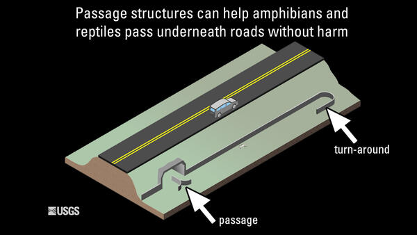
This video shows a California tiger salamander finding its way to an underpass designed to help amphibians and reptiles cross the road safely, with the help of a "turn-around" that helps guide the salamander back in the right direction as it travels away from the underpass.
This video shows a California tiger salamander finding its way to an underpass designed to help amphibians and reptiles cross the road safely, with the help of a "turn-around" that helps guide the salamander back in the right direction as it travels away from the underpass.
A small watershed restoration project proves that land farmed for half a century can be returned to a previous state. In 2002, Mike Osterholm bought 98 acres in northeastern Iowa, most of it annually tilled cropland. The land included the confluence of Duck Creek and Waterloo Creek.
A small watershed restoration project proves that land farmed for half a century can be returned to a previous state. In 2002, Mike Osterholm bought 98 acres in northeastern Iowa, most of it annually tilled cropland. The land included the confluence of Duck Creek and Waterloo Creek.


