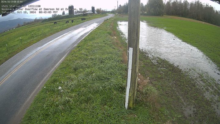
Nooksack River Overflow at Emerson Road at Everson, WA
Nooksack River Overflow at Emerson Road at Everson, WANooksack River Overflow at Emerson Road at Everson, WA. Check out this webcam to see the latest river conditions.

Official websites use .gov
A .gov website belongs to an official government organization in the United States.
Secure .gov websites use HTTPS
A lock () or https:// means you’ve safely connected to the .gov website. Share sensitive information only on official, secure websites.
If you have questions about flood response activities, research, or media inquiries regarding the USGS Washington Water Science Center please contact our Public Affairs Specialist, Sarah Dunn.
The USGS Flood Information page contains an abundance of information including:
Additionally, we've curated flood-related multimedia for Washington State which you may explore below.


Below are photos, videos, webcams, audio, and other multimedia items that relate to flooding in Washington State.

The USGS is developing methods to improve data collection during floods to gain new insight into the rise and fall of flood waters. In the past, the only data left behind after a flood was how high the water got, or the peak of the flood. This video presents the methodology that hydrologists are using to set up a Continuous Slope-area Reach in remote areas that are inaccessible during floods...
Nooksack River Overflow at Emerson Road at Everson, WA. Check out this webcam to see the latest river conditions.
Nooksack River Overflow at Emerson Road at Everson, WA. Check out this webcam to see the latest river conditions.


There are two basic types of floods: flash floods and the more widespread river floods. Flash floods generally cause greater loss of life and river floods generally cause greater loss of property. A flash flood occurs when runoff from excessive rainfall causes a rapid rise in the water height (stage) of a stream or normally-dry channel. Flash floods are more common in areas with a dry climate and...

Flood predictions require several types of data: The amount of rainfall occurring on a real-time basis. The rate of change in river stage on a real-time basis, which can help indicate the severity and immediacy of the threat. Knowledge about the type of storm producing the moisture, such as duration, intensity and areal extent, which can be valuable for determining possible severity of the...

FEMA is the official public source for flood maps for insurance purposes: FEMA’s Flood Map Service Center FEMA’s National Flood Hazard Layer NOAA is responsible for producing flood forecast maps that combine precipitation data with USGS streamflow data: NWS - National Water Prediction Service: River forecasts and long range flood outlook Coastal Inundation Dashboard: Real-time and historical...

The term “1,000-year flood” means that, statistically speaking, a flood of that magnitude (or greater) has a 1 in 1,000 chance of occurring in any given year. In terms of probability, the 1,000-year flood has a 0.1% chance of happening in any given year. These statistical values are based on observed data.

River forecasts (flood forecasts) are made by the National Weather Service - National Water Prediction Service. The overall map on the website uses color designations to give a quick overview of current conditions. A legend and other information can be selected in the right column. From the main map, click on a station to bring up a box which includes a graph showing current information and a...
Below are photos, videos, webcams, audio, and other multimedia items that relate to flooding in Washington State.
The USGS is developing methods to improve data collection during floods to gain new insight into the rise and fall of flood waters. In the past, the only data left behind after a flood was how high the water got, or the peak of the flood. This video presents the methodology that hydrologists are using to set up a Continuous Slope-area Reach in remote areas that are inaccessible during floods...
Nooksack River Overflow at Emerson Road at Everson, WA. Check out this webcam to see the latest river conditions.
Nooksack River Overflow at Emerson Road at Everson, WA. Check out this webcam to see the latest river conditions.
There are two basic types of floods: flash floods and the more widespread river floods. Flash floods generally cause greater loss of life and river floods generally cause greater loss of property. A flash flood occurs when runoff from excessive rainfall causes a rapid rise in the water height (stage) of a stream or normally-dry channel. Flash floods are more common in areas with a dry climate and...
Flood predictions require several types of data: The amount of rainfall occurring on a real-time basis. The rate of change in river stage on a real-time basis, which can help indicate the severity and immediacy of the threat. Knowledge about the type of storm producing the moisture, such as duration, intensity and areal extent, which can be valuable for determining possible severity of the...
FEMA is the official public source for flood maps for insurance purposes: FEMA’s Flood Map Service Center FEMA’s National Flood Hazard Layer NOAA is responsible for producing flood forecast maps that combine precipitation data with USGS streamflow data: NWS - National Water Prediction Service: River forecasts and long range flood outlook Coastal Inundation Dashboard: Real-time and historical...
The term “1,000-year flood” means that, statistically speaking, a flood of that magnitude (or greater) has a 1 in 1,000 chance of occurring in any given year. In terms of probability, the 1,000-year flood has a 0.1% chance of happening in any given year. These statistical values are based on observed data.
River forecasts (flood forecasts) are made by the National Weather Service - National Water Prediction Service. The overall map on the website uses color designations to give a quick overview of current conditions. A legend and other information can be selected in the right column. From the main map, click on a station to bring up a box which includes a graph showing current information and a...