
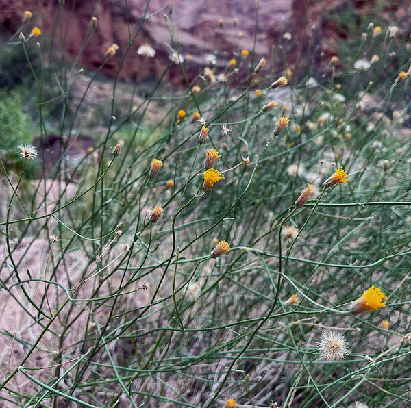
Bebbia juncea, a native plant growing in western Grand Canyon
Bebbia juncea, a native plant growing in western Grand CanyonBebbia juncea, a native plant growing in western Grand Canyon. Photo by Emily Palmquist, USGS.

Official websites use .gov
A .gov website belongs to an official government organization in the United States.
Secure .gov websites use HTTPS
A lock () or https:// means you’ve safely connected to the .gov website. Share sensitive information only on official, secure websites.
Where would we be without plants? They are the basis of the food chain and producers of oxygen - and so much more. From marsh grasses to mangroves, from sagebrush to sunflowers, getting to the root of the biology and ecology of plants is a critical component of USGS research.
Life as we know it wouldn’t be possible without plants. Plants maintain the atmosphere by producing oxygen and absorbing carbon dioxide, help keep our waterways clean, and provide us with food, shelter, and medicine. Plant communities are influenced by soil, terrain, climate, animals, and human activities, so different groups and types of plants are found in different regions of the country. Grassland plants such as the western prairie fringed orchid are found in the Great Plains, while desert plants such as the saguaro cactus are found in the Southwest. Approximately 391,000 species of vascular plants are currently known to science. Explore examples of USGS science on different plant types below.


Healthy plants are the foundation of healthy ecosystems. In an era of global change, our Nation’s forests, grasslands, wetlands, and other critical habitats are facing multiple threats that challenge our ability to maintain these ecosystems and the species that depend on them. USGS science provides the information needed to address these challenges and support healthy, thriving plant communities across the country.
Understanding, monitoring, and predicting threats to plants contributes to the USGS goal of providing science to support the protection, conservation, and enhancement of the Nation’s biodiversity. Through activities such as identifying strategies for controlling invasive cheatgrass, using novel techniques to identify the presence of disease-causing plant pathogens, and informing recovery plans for at-risk species, USGS science is tackling some of the biggest threats facing plants today.
The single biggest threat facing plants today is habitat loss. Changes in land use, such as the encroachment of agriculture or urban development into areas that were once covered by natural vegetation, reduce plant population sizes and alter the ecosystems that plants, animals, and humans rely on. Changes in land use can cause species extinctions, destabilize soil, increase erosion, and reduce water quality. USGS scientists are monitoring changes in land use to understand how they are affecting the plants and wildlife that depend on them. Explore examples of our science below:

Every plant and animal species has a native range where it evolved. When a species exists in a location beyond its natural range, it is considered a “non-native” species in that area. When a non-native species establishes in a new habitat, causing harm to the environment or humans, it becomes “invasive”. The annual estimated economic and health-related costs of invasive species in the U.S. have been reported at more than \$21 billion and adversely affect every state in the country. Invasive plants represent a major threat to global and local biodiversity while also having negative socio-economic and human health impacts. Invasive plants displace native plants, prevent native plant growth, reduce agricultural production, and induce allergies.
Invasive plants such as cheatgrass and buffelgrass have increased fire vulnerability and diminished grazing value across the western U.S. Aquatic invasive plants such as the weed hydrilla and giant fern salvinia are clogging waterways. To help combat these invaders, USGS scientists are using new tools to model the potential spread of high impact invasive species and to support the early detection and rapid response of invasive species before they are able to spread and cause harm. If an invasive plant is already established, USGS science is helping land managers reverse and mitigate the negative impacts these invasions are causing. Explore examples of our science to understand and reduce the threat of invasive plants below:
Visit our Invasive Species webpage to learn more about USGS activities to monitor and respond to the threat of invasive species across the country.

USGS research is addressing numerous diseases in both plants and animals and leading development efforts in advanced tools such as environmental DNA (eDNA) to assist in prevention and early detection. Explore examples of our science on plant diseases and pathogens below:
Climate helps shape ecosystems. Things like average temperatures, humidity, and rainfall determine where plants and animals lives. If a region’s climate changes, the ecosystem changes as well. Climate change poses one of the biggest threats to plants, leading to an increased spread of invasive species, increased vulnerability to insect pests, the loss of native plant species and changes in their distribution. USGS scientists are leading efforts to understand the current and future impacts of climate change on plants. This information helps management agencies identify adaptation strategies and actions that can help support vulnerable plant species in the face of a changing climate. Explore examples of our science below:
As a result of threats such as the spread of invasive species, disease, and climate and land use change, some plant species are in decline or in danger of extinction. The USGS provides management agencies such as the U.S. Fish and Wildlife Agency and National Park Service with scientific information to support conservation decisions for at-risk plant species. Explore examples of our science below:


Ecosystem restoration is the act of rehabilitating a degraded or lost ecosystems through activities such as planting native trees and shrubs and controlling invasive species. To do this, land managers need tools to help get the right plants, in the right place, at the right time for successful restoration. The USGS develops strategies and techniques to understand and facilitate the restoration of native species and habitats that have deteriorated due to threats such as invasive species and climate change. Explore examples of our science below:


Bebbia juncea, a native plant growing in western Grand Canyon. Photo by Emily Palmquist, USGS.
Bebbia juncea, a native plant growing in western Grand Canyon. Photo by Emily Palmquist, USGS.

USGS wetland scientists (GLSC; Ann Arbor, Michigan) collecting plant growth data during an invasive Phragmites australis control experiment. Photo credit: Spenser Widin, USGS.
USGS wetland scientists (GLSC; Ann Arbor, Michigan) collecting plant growth data during an invasive Phragmites australis control experiment. Photo credit: Spenser Widin, USGS.

USGS Director David Applegate along with Associate Director Anne Kinsinger and Dr. Kurt Kowalski listen to Dr. Wes Bickford describe invasive Phragmites australis and the research being done at the Great Lakes Science Center to control it. Photo Credit: Josh Miller (USGS)
USGS Director David Applegate along with Associate Director Anne Kinsinger and Dr. Kurt Kowalski listen to Dr. Wes Bickford describe invasive Phragmites australis and the research being done at the Great Lakes Science Center to control it. Photo Credit: Josh Miller (USGS)

Sam Droege (fore) arrived from Patuxent with plants for the Conte Lab's new pollinator garden. Sam Parker (back) assists with the planting.
Sam Droege (fore) arrived from Patuxent with plants for the Conte Lab's new pollinator garden. Sam Parker (back) assists with the planting.

American Beachgrass (Ammophila breviligulata) is planted on a beach in the town of Aquinnah on Martha's Vineyard, Massachusetts for stabilization.
American Beachgrass (Ammophila breviligulata) is planted on a beach in the town of Aquinnah on Martha's Vineyard, Massachusetts for stabilization.

A saguaro flowering in the desert near Tucson, AZ. Photo courtesy of Daniel Winkler, USGS, SBSC. Taken in spring, 2022.
A saguaro flowering in the desert near Tucson, AZ. Photo courtesy of Daniel Winkler, USGS, SBSC. Taken in spring, 2022.

A bee visits a saguaro flower near Tucson in Saguaro National Park, southern Arizona. Photo courtesy of Daniel Winkler, USGS SBSC.
A bee visits a saguaro flower near Tucson in Saguaro National Park, southern Arizona. Photo courtesy of Daniel Winkler, USGS SBSC.

Biological carbon sequestration is the natural ability of life and ecosystems to store carbon. Forests, peat marshes, and coastal wetlands are particularly good as storing carbon. Carbon can be stored in plant tissue, such as long-lived tree bark or in extensive root systems. Microbes break down plant and animal tissue through decomposition.
Biological carbon sequestration is the natural ability of life and ecosystems to store carbon. Forests, peat marshes, and coastal wetlands are particularly good as storing carbon. Carbon can be stored in plant tissue, such as long-lived tree bark or in extensive root systems. Microbes break down plant and animal tissue through decomposition.

A basic overview of the nitrogen cycle. Red arrows represent the portions of the nitrogen cycle (decomposition and nitrification) that are performed by our laboratory’s microbial culture.
A basic overview of the nitrogen cycle. Red arrows represent the portions of the nitrogen cycle (decomposition and nitrification) that are performed by our laboratory’s microbial culture.
The science items below are a sample of USGS science on plants and do not represent a complete list.


The multimedia items below are a sample of USGS media on plants and do not represent a complete list.
Bebbia juncea, a native plant growing in western Grand Canyon. Photo by Emily Palmquist, USGS.
Bebbia juncea, a native plant growing in western Grand Canyon. Photo by Emily Palmquist, USGS.
USGS wetland scientists (GLSC; Ann Arbor, Michigan) collecting plant growth data during an invasive Phragmites australis control experiment. Photo credit: Spenser Widin, USGS.
USGS wetland scientists (GLSC; Ann Arbor, Michigan) collecting plant growth data during an invasive Phragmites australis control experiment. Photo credit: Spenser Widin, USGS.
USGS Director David Applegate along with Associate Director Anne Kinsinger and Dr. Kurt Kowalski listen to Dr. Wes Bickford describe invasive Phragmites australis and the research being done at the Great Lakes Science Center to control it. Photo Credit: Josh Miller (USGS)
USGS Director David Applegate along with Associate Director Anne Kinsinger and Dr. Kurt Kowalski listen to Dr. Wes Bickford describe invasive Phragmites australis and the research being done at the Great Lakes Science Center to control it. Photo Credit: Josh Miller (USGS)
Sam Droege (fore) arrived from Patuxent with plants for the Conte Lab's new pollinator garden. Sam Parker (back) assists with the planting.
Sam Droege (fore) arrived from Patuxent with plants for the Conte Lab's new pollinator garden. Sam Parker (back) assists with the planting.
American Beachgrass (Ammophila breviligulata) is planted on a beach in the town of Aquinnah on Martha's Vineyard, Massachusetts for stabilization.
American Beachgrass (Ammophila breviligulata) is planted on a beach in the town of Aquinnah on Martha's Vineyard, Massachusetts for stabilization.
A saguaro flowering in the desert near Tucson, AZ. Photo courtesy of Daniel Winkler, USGS, SBSC. Taken in spring, 2022.
A saguaro flowering in the desert near Tucson, AZ. Photo courtesy of Daniel Winkler, USGS, SBSC. Taken in spring, 2022.
A bee visits a saguaro flower near Tucson in Saguaro National Park, southern Arizona. Photo courtesy of Daniel Winkler, USGS SBSC.
A bee visits a saguaro flower near Tucson in Saguaro National Park, southern Arizona. Photo courtesy of Daniel Winkler, USGS SBSC.
Biological carbon sequestration is the natural ability of life and ecosystems to store carbon. Forests, peat marshes, and coastal wetlands are particularly good as storing carbon. Carbon can be stored in plant tissue, such as long-lived tree bark or in extensive root systems. Microbes break down plant and animal tissue through decomposition.
Biological carbon sequestration is the natural ability of life and ecosystems to store carbon. Forests, peat marshes, and coastal wetlands are particularly good as storing carbon. Carbon can be stored in plant tissue, such as long-lived tree bark or in extensive root systems. Microbes break down plant and animal tissue through decomposition.
A basic overview of the nitrogen cycle. Red arrows represent the portions of the nitrogen cycle (decomposition and nitrification) that are performed by our laboratory’s microbial culture.
A basic overview of the nitrogen cycle. Red arrows represent the portions of the nitrogen cycle (decomposition and nitrification) that are performed by our laboratory’s microbial culture.

Thumbnail for "I Am A...Disease Ecologist" whiteboard video.
Thumbnail for "I Am A...Disease Ecologist" whiteboard video.

Tidal freshwater forest transitioning to brackish marsh along the Pamunkey River, Virginia, as low-level salinization kills trees (forming ‘ghost forest’) that are replaced with marsh plants.
Tidal freshwater forest transitioning to brackish marsh along the Pamunkey River, Virginia, as low-level salinization kills trees (forming ‘ghost forest’) that are replaced with marsh plants.

A prairie sunflower (Helianthus petiolaris) stands out from the dry landscape of sand and beach grass at West Beach in Indiana Dunes National Park. Photo credit: Johanna Nifosi, USGS.
A prairie sunflower (Helianthus petiolaris) stands out from the dry landscape of sand and beach grass at West Beach in Indiana Dunes National Park. Photo credit: Johanna Nifosi, USGS.

Hawkmoth flying near milkweed plant in North Dakota. Northern Prairie Wildlife Research Center is monitoring milkweed populations across the Central United States.
Hawkmoth flying near milkweed plant in North Dakota. Northern Prairie Wildlife Research Center is monitoring milkweed populations across the Central United States.

A paddle through wetlands at Fish Point State Game Area in Saginaw Bay on Lake Huron. Photo credit: Wes Bickford, USGS.
A paddle through wetlands at Fish Point State Game Area in Saginaw Bay on Lake Huron. Photo credit: Wes Bickford, USGS.

Connecting powerline rights-of-way vegetation management to improve pollinator habitat. A USGS RAMPS technician samples pollinating insects along the Salt River Project powerline that crosses through Apache-Sitgreaves and Tonto National Forests.
Connecting powerline rights-of-way vegetation management to improve pollinator habitat. A USGS RAMPS technician samples pollinating insects along the Salt River Project powerline that crosses through Apache-Sitgreaves and Tonto National Forests.
The extensive rangelands across the Western United States are threatened by invasive grasses, climate change, and altered fire regimes that can disturb the landscape. The largely semi-arid lands are also important for the survival of species that need undisturbed sagebrush ecosystems to thrive.
The extensive rangelands across the Western United States are threatened by invasive grasses, climate change, and altered fire regimes that can disturb the landscape. The largely semi-arid lands are also important for the survival of species that need undisturbed sagebrush ecosystems to thrive.

Research scientist Lesley DeFalco works on native and invasive annual plant sampling at the site of the Tramp Fire,one of 12 fires for which the USGS and the BLM are implementing landscape scale restoration treatments.
Research scientist Lesley DeFalco works on native and invasive annual plant sampling at the site of the Tramp Fire,one of 12 fires for which the USGS and the BLM are implementing landscape scale restoration treatments.

Three researchers on the summit of Dancing Lady Mountain set up tapes and grids to complete a Global Observation Research Initiative in Alpine Environments network (GLORIA) vegetation survey.
Three researchers on the summit of Dancing Lady Mountain set up tapes and grids to complete a Global Observation Research Initiative in Alpine Environments network (GLORIA) vegetation survey.

Researchers evaluate vegetation during a Global Observation Research Initiative in Alpine (GLORIA) alpine plant survey near the summit of Seward Mountain in Glacier National Park, Montana.
Researchers evaluate vegetation during a Global Observation Research Initiative in Alpine (GLORIA) alpine plant survey near the summit of Seward Mountain in Glacier National Park, Montana.

Researcher evaluates vegetation during a GLORIA alpine plant survey near the summit of Dancing Lady Mountain in Glacier National Park, Montana.
Researcher evaluates vegetation during a GLORIA alpine plant survey near the summit of Dancing Lady Mountain in Glacier National Park, Montana.
The FAQs below are a sample of USGS science on plants and do not represent a complete list.

Under the Endangered Species Act (ESA), plant and animal species may be listed as either endangered or threatened. “Endangered” means a species is in danger of extinction throughout all or a significant portion of its range. “Threatened” means a species is likely to become endangered within the foreseeable future. States have their own ESA-type laws, so species can have different Threatened...

An invasive species is an introduced, nonnative organism (disease, parasite, plant, or animal) that begins to spread or expand its range from the site of its original introduction and that has the potential to cause harm to the environment, the economy, or to human health. A few well-known examples include the unintentional introduction of the West Nile virus, chestnut blight, the South American...

Chinese tallow has been cultivated in nurseries and sold as an ornamental tree used for landscaping; however, it is now classified as a nuisance species in some locations and can no longer be sold. It has separate pollen and seed-bearing flowers, and seeds can be spread by birds and by moving water. Chinese tallow has spread from South Carolina all the way down to Florida, west into Texas, and has...

The invasive Chinese tallow tree has the ability to reach reproductive age in as little as 3 years and to remain productive for at least 60 years. It does not seem to have a preference for disturbed areas over undisturbed areas and can grow in a variety of places. It can also grow in both full sunlight and shade. It is more tolerant of salinity and flooding than quite a few other native species...

Buffelgrass is a perennial grass from Africa that is invasive to the Sonoran Desert of the Southwest United States, where it threatens desert ecosystems by out-competing native plants and altering fire regimes. It has the potential to transform the Sonoran Desert ecosystem from a diverse assemblage of plants to a grassland monoculture. Buffelgrass was brought to Arizona in the 1930s for erosion...

Tamarisk is an invasive shrub or small tree that is found across the American West. Also known as saltcedar, tamarisk favors sites that are inhospitable to native streamside plants because of high salinity, low water availability, and altered streamflow regimes created by dams. Researchers debate the extent of tamarisk’s negative impacts, but this invasive species can and does alter habitat...
Loss of plant diversity is the primary cause of native bee decline. About 30-50% of all native bees are highly specialized, so if the plant they rely on disappears, the bees go away. If the bees disappear, the plant is unable to reproduce and dies out. While some of the plants pollinated by native bees are important food crops, other plants pollinated by native bees are critical for healthy...

Bees feed on and require both nectar and pollen. The nectar is for energy and the pollen provides protein and other nutrients. Most pollen is used by bees as larvae food, but bees also transfer it from plant-to-plant, providing the pollination services needed by plants and nature as a whole. Learn more: USGS Native Bee Inventory and Monitoring Program Bees of the Northeastern U.S.

About 75% of North American plant species require an insect—mostly bees—to move their pollen from one plant to another to effect pollination. Unlike the well-known behavior of the non-native honeybees, there is much that we don’t know about native bees. Many native bees are smaller in size than a grain of rice. Of approximately 4,000 native bee species in the United States, 10% have not been named...

Do you enjoy a hot cup of coffee, a juicy peach, an-apple-a-day, almonds, rich and creamy dates, a handful of plump cashews, or vine-ripened tomatoes? Do you enjoy seeing the native flowers and plants that surround you? If so, you depend on pollinators. Wherever flowering plants flourish, pollinating bees, birds, butterflies, bats and other animals are hard at work, providing vital but often...

Wetlands provide habitat for thousands of species of aquatic and terrestrial plants and animals. Wetlands are valuable for flood protection, water quality improvement, shoreline erosion control, natural products, recreation, and aesthetics. Wetlands are among the most productive habitats on earth providing shelter and nursery areas for commercially and recreationally important animals like fish...

Wetlands are transitional areas, sandwiched between permanently flooded deepwater environments and well-drained uplands, where the water table is usually at or near the surface or the land is covered by shallow water. They include mangroves, marshes (salt, brackish, intermediate, and fresh), swamps, forested wetlands, bogs, wet prairies, prairie potholes, and vernal pools. In general terms...
Where would we be without plants? They are the basis of the food chain and producers of oxygen - and so much more. From marsh grasses to mangroves, from sagebrush to sunflowers, getting to the root of the biology and ecology of plants is a critical component of USGS research.
Life as we know it wouldn’t be possible without plants. Plants maintain the atmosphere by producing oxygen and absorbing carbon dioxide, help keep our waterways clean, and provide us with food, shelter, and medicine. Plant communities are influenced by soil, terrain, climate, animals, and human activities, so different groups and types of plants are found in different regions of the country. Grassland plants such as the western prairie fringed orchid are found in the Great Plains, while desert plants such as the saguaro cactus are found in the Southwest. Approximately 391,000 species of vascular plants are currently known to science. Explore examples of USGS science on different plant types below.
Healthy plants are the foundation of healthy ecosystems. In an era of global change, our Nation’s forests, grasslands, wetlands, and other critical habitats are facing multiple threats that challenge our ability to maintain these ecosystems and the species that depend on them. USGS science provides the information needed to address these challenges and support healthy, thriving plant communities across the country.
Understanding, monitoring, and predicting threats to plants contributes to the USGS goal of providing science to support the protection, conservation, and enhancement of the Nation’s biodiversity. Through activities such as identifying strategies for controlling invasive cheatgrass, using novel techniques to identify the presence of disease-causing plant pathogens, and informing recovery plans for at-risk species, USGS science is tackling some of the biggest threats facing plants today.
The single biggest threat facing plants today is habitat loss. Changes in land use, such as the encroachment of agriculture or urban development into areas that were once covered by natural vegetation, reduce plant population sizes and alter the ecosystems that plants, animals, and humans rely on. Changes in land use can cause species extinctions, destabilize soil, increase erosion, and reduce water quality. USGS scientists are monitoring changes in land use to understand how they are affecting the plants and wildlife that depend on them. Explore examples of our science below:
Every plant and animal species has a native range where it evolved. When a species exists in a location beyond its natural range, it is considered a “non-native” species in that area. When a non-native species establishes in a new habitat, causing harm to the environment or humans, it becomes “invasive”. The annual estimated economic and health-related costs of invasive species in the U.S. have been reported at more than \$21 billion and adversely affect every state in the country. Invasive plants represent a major threat to global and local biodiversity while also having negative socio-economic and human health impacts. Invasive plants displace native plants, prevent native plant growth, reduce agricultural production, and induce allergies.
Invasive plants such as cheatgrass and buffelgrass have increased fire vulnerability and diminished grazing value across the western U.S. Aquatic invasive plants such as the weed hydrilla and giant fern salvinia are clogging waterways. To help combat these invaders, USGS scientists are using new tools to model the potential spread of high impact invasive species and to support the early detection and rapid response of invasive species before they are able to spread and cause harm. If an invasive plant is already established, USGS science is helping land managers reverse and mitigate the negative impacts these invasions are causing. Explore examples of our science to understand and reduce the threat of invasive plants below:
Visit our Invasive Species webpage to learn more about USGS activities to monitor and respond to the threat of invasive species across the country.
USGS research is addressing numerous diseases in both plants and animals and leading development efforts in advanced tools such as environmental DNA (eDNA) to assist in prevention and early detection. Explore examples of our science on plant diseases and pathogens below:
Climate helps shape ecosystems. Things like average temperatures, humidity, and rainfall determine where plants and animals lives. If a region’s climate changes, the ecosystem changes as well. Climate change poses one of the biggest threats to plants, leading to an increased spread of invasive species, increased vulnerability to insect pests, the loss of native plant species and changes in their distribution. USGS scientists are leading efforts to understand the current and future impacts of climate change on plants. This information helps management agencies identify adaptation strategies and actions that can help support vulnerable plant species in the face of a changing climate. Explore examples of our science below:
As a result of threats such as the spread of invasive species, disease, and climate and land use change, some plant species are in decline or in danger of extinction. The USGS provides management agencies such as the U.S. Fish and Wildlife Agency and National Park Service with scientific information to support conservation decisions for at-risk plant species. Explore examples of our science below:
Ecosystem restoration is the act of rehabilitating a degraded or lost ecosystems through activities such as planting native trees and shrubs and controlling invasive species. To do this, land managers need tools to help get the right plants, in the right place, at the right time for successful restoration. The USGS develops strategies and techniques to understand and facilitate the restoration of native species and habitats that have deteriorated due to threats such as invasive species and climate change. Explore examples of our science below:
Bebbia juncea, a native plant growing in western Grand Canyon. Photo by Emily Palmquist, USGS.
Bebbia juncea, a native plant growing in western Grand Canyon. Photo by Emily Palmquist, USGS.
USGS wetland scientists (GLSC; Ann Arbor, Michigan) collecting plant growth data during an invasive Phragmites australis control experiment. Photo credit: Spenser Widin, USGS.
USGS wetland scientists (GLSC; Ann Arbor, Michigan) collecting plant growth data during an invasive Phragmites australis control experiment. Photo credit: Spenser Widin, USGS.
USGS Director David Applegate along with Associate Director Anne Kinsinger and Dr. Kurt Kowalski listen to Dr. Wes Bickford describe invasive Phragmites australis and the research being done at the Great Lakes Science Center to control it. Photo Credit: Josh Miller (USGS)
USGS Director David Applegate along with Associate Director Anne Kinsinger and Dr. Kurt Kowalski listen to Dr. Wes Bickford describe invasive Phragmites australis and the research being done at the Great Lakes Science Center to control it. Photo Credit: Josh Miller (USGS)
Sam Droege (fore) arrived from Patuxent with plants for the Conte Lab's new pollinator garden. Sam Parker (back) assists with the planting.
Sam Droege (fore) arrived from Patuxent with plants for the Conte Lab's new pollinator garden. Sam Parker (back) assists with the planting.
American Beachgrass (Ammophila breviligulata) is planted on a beach in the town of Aquinnah on Martha's Vineyard, Massachusetts for stabilization.
American Beachgrass (Ammophila breviligulata) is planted on a beach in the town of Aquinnah on Martha's Vineyard, Massachusetts for stabilization.
A saguaro flowering in the desert near Tucson, AZ. Photo courtesy of Daniel Winkler, USGS, SBSC. Taken in spring, 2022.
A saguaro flowering in the desert near Tucson, AZ. Photo courtesy of Daniel Winkler, USGS, SBSC. Taken in spring, 2022.
A bee visits a saguaro flower near Tucson in Saguaro National Park, southern Arizona. Photo courtesy of Daniel Winkler, USGS SBSC.
A bee visits a saguaro flower near Tucson in Saguaro National Park, southern Arizona. Photo courtesy of Daniel Winkler, USGS SBSC.
Biological carbon sequestration is the natural ability of life and ecosystems to store carbon. Forests, peat marshes, and coastal wetlands are particularly good as storing carbon. Carbon can be stored in plant tissue, such as long-lived tree bark or in extensive root systems. Microbes break down plant and animal tissue through decomposition.
Biological carbon sequestration is the natural ability of life and ecosystems to store carbon. Forests, peat marshes, and coastal wetlands are particularly good as storing carbon. Carbon can be stored in plant tissue, such as long-lived tree bark or in extensive root systems. Microbes break down plant and animal tissue through decomposition.
A basic overview of the nitrogen cycle. Red arrows represent the portions of the nitrogen cycle (decomposition and nitrification) that are performed by our laboratory’s microbial culture.
A basic overview of the nitrogen cycle. Red arrows represent the portions of the nitrogen cycle (decomposition and nitrification) that are performed by our laboratory’s microbial culture.
The science items below are a sample of USGS science on plants and do not represent a complete list.
The multimedia items below are a sample of USGS media on plants and do not represent a complete list.
Bebbia juncea, a native plant growing in western Grand Canyon. Photo by Emily Palmquist, USGS.
Bebbia juncea, a native plant growing in western Grand Canyon. Photo by Emily Palmquist, USGS.
USGS wetland scientists (GLSC; Ann Arbor, Michigan) collecting plant growth data during an invasive Phragmites australis control experiment. Photo credit: Spenser Widin, USGS.
USGS wetland scientists (GLSC; Ann Arbor, Michigan) collecting plant growth data during an invasive Phragmites australis control experiment. Photo credit: Spenser Widin, USGS.
USGS Director David Applegate along with Associate Director Anne Kinsinger and Dr. Kurt Kowalski listen to Dr. Wes Bickford describe invasive Phragmites australis and the research being done at the Great Lakes Science Center to control it. Photo Credit: Josh Miller (USGS)
USGS Director David Applegate along with Associate Director Anne Kinsinger and Dr. Kurt Kowalski listen to Dr. Wes Bickford describe invasive Phragmites australis and the research being done at the Great Lakes Science Center to control it. Photo Credit: Josh Miller (USGS)
Sam Droege (fore) arrived from Patuxent with plants for the Conte Lab's new pollinator garden. Sam Parker (back) assists with the planting.
Sam Droege (fore) arrived from Patuxent with plants for the Conte Lab's new pollinator garden. Sam Parker (back) assists with the planting.
American Beachgrass (Ammophila breviligulata) is planted on a beach in the town of Aquinnah on Martha's Vineyard, Massachusetts for stabilization.
American Beachgrass (Ammophila breviligulata) is planted on a beach in the town of Aquinnah on Martha's Vineyard, Massachusetts for stabilization.
A saguaro flowering in the desert near Tucson, AZ. Photo courtesy of Daniel Winkler, USGS, SBSC. Taken in spring, 2022.
A saguaro flowering in the desert near Tucson, AZ. Photo courtesy of Daniel Winkler, USGS, SBSC. Taken in spring, 2022.
A bee visits a saguaro flower near Tucson in Saguaro National Park, southern Arizona. Photo courtesy of Daniel Winkler, USGS SBSC.
A bee visits a saguaro flower near Tucson in Saguaro National Park, southern Arizona. Photo courtesy of Daniel Winkler, USGS SBSC.
Biological carbon sequestration is the natural ability of life and ecosystems to store carbon. Forests, peat marshes, and coastal wetlands are particularly good as storing carbon. Carbon can be stored in plant tissue, such as long-lived tree bark or in extensive root systems. Microbes break down plant and animal tissue through decomposition.
Biological carbon sequestration is the natural ability of life and ecosystems to store carbon. Forests, peat marshes, and coastal wetlands are particularly good as storing carbon. Carbon can be stored in plant tissue, such as long-lived tree bark or in extensive root systems. Microbes break down plant and animal tissue through decomposition.
A basic overview of the nitrogen cycle. Red arrows represent the portions of the nitrogen cycle (decomposition and nitrification) that are performed by our laboratory’s microbial culture.
A basic overview of the nitrogen cycle. Red arrows represent the portions of the nitrogen cycle (decomposition and nitrification) that are performed by our laboratory’s microbial culture.
Thumbnail for "I Am A...Disease Ecologist" whiteboard video.
Thumbnail for "I Am A...Disease Ecologist" whiteboard video.
Tidal freshwater forest transitioning to brackish marsh along the Pamunkey River, Virginia, as low-level salinization kills trees (forming ‘ghost forest’) that are replaced with marsh plants.
Tidal freshwater forest transitioning to brackish marsh along the Pamunkey River, Virginia, as low-level salinization kills trees (forming ‘ghost forest’) that are replaced with marsh plants.
A prairie sunflower (Helianthus petiolaris) stands out from the dry landscape of sand and beach grass at West Beach in Indiana Dunes National Park. Photo credit: Johanna Nifosi, USGS.
A prairie sunflower (Helianthus petiolaris) stands out from the dry landscape of sand and beach grass at West Beach in Indiana Dunes National Park. Photo credit: Johanna Nifosi, USGS.
Hawkmoth flying near milkweed plant in North Dakota. Northern Prairie Wildlife Research Center is monitoring milkweed populations across the Central United States.
Hawkmoth flying near milkweed plant in North Dakota. Northern Prairie Wildlife Research Center is monitoring milkweed populations across the Central United States.
A paddle through wetlands at Fish Point State Game Area in Saginaw Bay on Lake Huron. Photo credit: Wes Bickford, USGS.
A paddle through wetlands at Fish Point State Game Area in Saginaw Bay on Lake Huron. Photo credit: Wes Bickford, USGS.
Connecting powerline rights-of-way vegetation management to improve pollinator habitat. A USGS RAMPS technician samples pollinating insects along the Salt River Project powerline that crosses through Apache-Sitgreaves and Tonto National Forests.
Connecting powerline rights-of-way vegetation management to improve pollinator habitat. A USGS RAMPS technician samples pollinating insects along the Salt River Project powerline that crosses through Apache-Sitgreaves and Tonto National Forests.
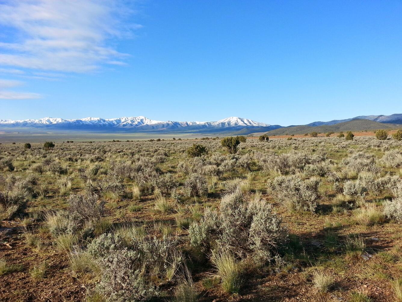
The extensive rangelands across the Western United States are threatened by invasive grasses, climate change, and altered fire regimes that can disturb the landscape. The largely semi-arid lands are also important for the survival of species that need undisturbed sagebrush ecosystems to thrive.
The extensive rangelands across the Western United States are threatened by invasive grasses, climate change, and altered fire regimes that can disturb the landscape. The largely semi-arid lands are also important for the survival of species that need undisturbed sagebrush ecosystems to thrive.
Research scientist Lesley DeFalco works on native and invasive annual plant sampling at the site of the Tramp Fire,one of 12 fires for which the USGS and the BLM are implementing landscape scale restoration treatments.
Research scientist Lesley DeFalco works on native and invasive annual plant sampling at the site of the Tramp Fire,one of 12 fires for which the USGS and the BLM are implementing landscape scale restoration treatments.
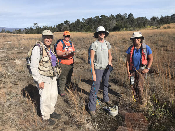
Three researchers on the summit of Dancing Lady Mountain set up tapes and grids to complete a Global Observation Research Initiative in Alpine Environments network (GLORIA) vegetation survey.
Three researchers on the summit of Dancing Lady Mountain set up tapes and grids to complete a Global Observation Research Initiative in Alpine Environments network (GLORIA) vegetation survey.
Researchers evaluate vegetation during a Global Observation Research Initiative in Alpine (GLORIA) alpine plant survey near the summit of Seward Mountain in Glacier National Park, Montana.
Researchers evaluate vegetation during a Global Observation Research Initiative in Alpine (GLORIA) alpine plant survey near the summit of Seward Mountain in Glacier National Park, Montana.
Researcher evaluates vegetation during a GLORIA alpine plant survey near the summit of Dancing Lady Mountain in Glacier National Park, Montana.
Researcher evaluates vegetation during a GLORIA alpine plant survey near the summit of Dancing Lady Mountain in Glacier National Park, Montana.
The FAQs below are a sample of USGS science on plants and do not represent a complete list.
Under the Endangered Species Act (ESA), plant and animal species may be listed as either endangered or threatened. “Endangered” means a species is in danger of extinction throughout all or a significant portion of its range. “Threatened” means a species is likely to become endangered within the foreseeable future. States have their own ESA-type laws, so species can have different Threatened...
An invasive species is an introduced, nonnative organism (disease, parasite, plant, or animal) that begins to spread or expand its range from the site of its original introduction and that has the potential to cause harm to the environment, the economy, or to human health. A few well-known examples include the unintentional introduction of the West Nile virus, chestnut blight, the South American...
Chinese tallow has been cultivated in nurseries and sold as an ornamental tree used for landscaping; however, it is now classified as a nuisance species in some locations and can no longer be sold. It has separate pollen and seed-bearing flowers, and seeds can be spread by birds and by moving water. Chinese tallow has spread from South Carolina all the way down to Florida, west into Texas, and has...
The invasive Chinese tallow tree has the ability to reach reproductive age in as little as 3 years and to remain productive for at least 60 years. It does not seem to have a preference for disturbed areas over undisturbed areas and can grow in a variety of places. It can also grow in both full sunlight and shade. It is more tolerant of salinity and flooding than quite a few other native species...
Buffelgrass is a perennial grass from Africa that is invasive to the Sonoran Desert of the Southwest United States, where it threatens desert ecosystems by out-competing native plants and altering fire regimes. It has the potential to transform the Sonoran Desert ecosystem from a diverse assemblage of plants to a grassland monoculture. Buffelgrass was brought to Arizona in the 1930s for erosion...
Tamarisk is an invasive shrub or small tree that is found across the American West. Also known as saltcedar, tamarisk favors sites that are inhospitable to native streamside plants because of high salinity, low water availability, and altered streamflow regimes created by dams. Researchers debate the extent of tamarisk’s negative impacts, but this invasive species can and does alter habitat...
Loss of plant diversity is the primary cause of native bee decline. About 30-50% of all native bees are highly specialized, so if the plant they rely on disappears, the bees go away. If the bees disappear, the plant is unable to reproduce and dies out. While some of the plants pollinated by native bees are important food crops, other plants pollinated by native bees are critical for healthy...
Bees feed on and require both nectar and pollen. The nectar is for energy and the pollen provides protein and other nutrients. Most pollen is used by bees as larvae food, but bees also transfer it from plant-to-plant, providing the pollination services needed by plants and nature as a whole. Learn more: USGS Native Bee Inventory and Monitoring Program Bees of the Northeastern U.S.
About 75% of North American plant species require an insect—mostly bees—to move their pollen from one plant to another to effect pollination. Unlike the well-known behavior of the non-native honeybees, there is much that we don’t know about native bees. Many native bees are smaller in size than a grain of rice. Of approximately 4,000 native bee species in the United States, 10% have not been named...
Do you enjoy a hot cup of coffee, a juicy peach, an-apple-a-day, almonds, rich and creamy dates, a handful of plump cashews, or vine-ripened tomatoes? Do you enjoy seeing the native flowers and plants that surround you? If so, you depend on pollinators. Wherever flowering plants flourish, pollinating bees, birds, butterflies, bats and other animals are hard at work, providing vital but often...
Wetlands provide habitat for thousands of species of aquatic and terrestrial plants and animals. Wetlands are valuable for flood protection, water quality improvement, shoreline erosion control, natural products, recreation, and aesthetics. Wetlands are among the most productive habitats on earth providing shelter and nursery areas for commercially and recreationally important animals like fish...
Wetlands are transitional areas, sandwiched between permanently flooded deepwater environments and well-drained uplands, where the water table is usually at or near the surface or the land is covered by shallow water. They include mangroves, marshes (salt, brackish, intermediate, and fresh), swamps, forested wetlands, bogs, wet prairies, prairie potholes, and vernal pools. In general terms...

