
The "From Icefield to Ocean Poster" depicts the important linkages between glaciers and the ocean. The product is a result of Alaska Climate Science Center research projects and workshops.
Ocean and Climate
Marine Climate History
Paleoclimate Research
Ecosystems: EXPRESS
Gas Hydrates Project
The Impact of Sea-Level Rise and Climate Change on the Pacific Ocean
Pacific Island Partnership: Adapting Together
Science Explorer: Climate
The USGS works to understand Earth’s history, past climate conditions, and to forecast climate change impacts. The ocean is an amazing repository for Earth’s climatic history. Earth’s ocean and climate are intrinsically connected and heavily influence one another in many ways. The USGS uses ocean geologic records to better understand current and future climate changes and potential impacts.
Media
Sources/Usage: Public Domain. View Media Details
Changing climate influences many aspects of the ocean, from warming surface waters and altering ocean chemistry to affecting ecosystem function and health. The ocean and its circulation patterns are critical drivers of Earth’s climate and weather patterns.
With the ocean covering more than 70% of the Earth, it plays a large role in controlling the planet’s temperature. The ocean absorbs an enormous amount of heat from the sun—in fact, the top few meters alone store as much heat as the Earth’s atmosphere! As water is very good at storing heat, it spreads the heat around the planet through circulating currents driven by temperature and density differences. These global circulation patterns affect our daily weather and influence long-term climate patterns.
A Changing Ocean
As water heats up, it also expands in volume—a process known as thermal expansion—which causes sea levels to rise. As the Earth warms and cools, the volume of the ocean changes, affecting the volume of ice and land areas covered with ocean or ice. These changes can occur abruptly, such as during transitions from glacial to interglacial conditions, or over long periods of time. Learn more about sea level rise research here.
Changes in water temperatures, salinity and other chemical properties, can alter related circulation patterns. Altogether, these changes can also affect the behavior and physiology of many species by having profound impacts on the timing and availability and timing such as changing food webs, of food, reproduction and migratory patterns. Coral bleaching is one way corals respond to warming sea water temperatures.
The ocean also absorbs gases, which can affect its chemical properties. For example, as carbon dioxide in the atmosphere is absorbed by the ocean, it causes the pH to lower in a process called ocean acidification. Ocean acidification can lead to dissolution of the shells and skeletons of many marine organisms—including economically important shellfish in the seafood industry and ecologically important corals that support biodiversity. It can also dissolve carbonate sediment and alter seafloor elevation and form. USGS monitors the effects of ocean acidification on coastal and marine ecosystems to help inform efforts to mitigate these impacts.
Media

Sources/Usage: Public Domain. View Media Details
USGS Ocean and Climate Research
Ocean science is critical to improving the understanding of Earth's inner workings. From remote-sensing to marine geology and paleoclimate analyses, USGS is an important partner with other federal agencies and international experts working to expand our knowledge about Earth's climate history, especially as related to current conditions. This science improves our ability to understand the factors that affect climate change as well as forecast future climate conditions, their potential impacts and how best to mitigate or adapt to them.
With remote-sensing technology, for example, cameras on satellites can make images of temperature shifts in the open ocean or monitor changes in the formation of sea ice at the poles. Remote-sensing also includes sonar systems on ships, which can be used to create images of the ocean floor and uncover clues about past climatic conditions: USGS researchers studying iceberg tracks, or scours, on the Atlantic seafloor found that during the Last Glacial Period 30,000 years ago, icebergs perhaps as tall as the Eiffel Tower drifted south along the Atlantic coast of North America, ferried along by cold-water currents created during periods of catastrophic glacial melting.
The USGS develops and uses innovative methods to measure climatic and oceanic conditions throughout Earth’s history including sea surface and bottom water temperatures, salinity, relative sea level, precipitation patterns, oceanic productivity, and terrestrial inputs to the ocean system. Data on past climatic conditions in the oceans—the study of geologic records known as paleoceanography—can be combined with data on current conditions to try to predict how our ocean will affect Earth’s future climate patterns.
In order to understand the past, USGS scientists analyze “proxies” which serve to indicate past conditions through biological or geological evidence. Some proxies include marine sediment and organisms that secrete their shells from seawater such as plankton, clams, and corals. Proxies for seawater geochemistry reflect the environmental conditions when and where they were formed. These proxies obtained in geologic deposits serve as archives that can be used to reconstruct Earth’s historic conditions so we can better predict what changes might occur in the future.


Sources/Usage: Public Domain. View Media Details
Science

Pacific Islands Climate Adaptation Science Center (PI-CASC): Adapting Together
The Pacific Islands Climate Adaptation Science Center, or PI-CASC (pronounced “pie-cask”), supports regional climate expertise tailored to the unique challenges faced by island communities and ecosystems. PI-CASC serves communities on Hawaiʻi and the U.S.-Affiliated Pacific Islands, supporting resilience and adaptation in the face of climate change.

The Impact of Sea-Level Rise and Climate Change on Pacific Ocean Atolls
Providing basic understanding and specific information on storm-wave inundation of atoll islands that house Department of Defense installations, and assessing the resulting impact of sea-level rise and storm-wave inundation on infrastructure and freshwater availability under a variety of sea-level rise and climatic scenarios.

Paleoclimate Proxies
Paleoclimate proxies are physical, chemical and biological materials preserved within the geologic record (in paleoclimate archives) that can be analyzed and correlated with climate or environmental parameters in the modern world. Scientists combine proxy-based paleoclimate reconstructions with instrumental records (such as thermometer and rain gauge readings) to expand our understanding of...

Paleoclimate Research
Lessons from the Past, Roadmap for the Future The present-day climate of the Earth is influenced by a combination of natural climate variability, increased concentrations of greenhouse gases in the atmosphere since the Industrial Revolution, and changes in land cover (such as conversion from forest to agriculture and back again).

Ecosystems: EXPRESS
The continental shelf and slope offshore California, Oregon, and Washington are home to deep-sea corals, chemosynthetic communities, and other sensitive habitats that could be impacted by the development of energy and mineral resources. The EXPRESS (Expanding Pacific Research and Exploration of Submerged Systems) campaign will map and characterize these special areas to help guide ocean management...
Multimedia

From Icefield to Ocean Poster
The "From Icefield to Ocean Poster" depicts the important linkages between glaciers and the ocean. The product is a result of Alaska Climate Science Center research projects and workshops.

Ridge-to-Reef and Icefield-to-Ocean: Collaborative Research in Extreme Environments
Ridge-to-Reef and Icefield-to-Ocean: Collaborative Research in Extreme EnvironmentsSteep watersheds with dramatic environmental gradients are common features of both the Pacific Islands and Southeast Alaska.
Ridge-to-Reef and Icefield-to-Ocean: Collaborative Research in Extreme Environments
Ridge-to-Reef and Icefield-to-Ocean: Collaborative Research in Extreme EnvironmentsSteep watersheds with dramatic environmental gradients are common features of both the Pacific Islands and Southeast Alaska.

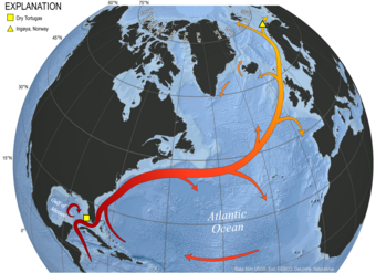
Map of North Atlantic and Gulf Stream
Figure 3. Map of the North Atlantic Ocean illustrating the approximate path of the Gulf Stream / North Atlantic Current system.
Figure 3. Map of the North Atlantic Ocean illustrating the approximate path of the Gulf Stream / North Atlantic Current system.

Adrian Garcia with HyPrCAL laboratory equipment
The USGS Gas Hydrates Project develops and tests new tools to address the critical knowledge gaps identified as scientists analyze hydrate-bearing pressure cores recovered during field programs.
The USGS Gas Hydrates Project develops and tests new tools to address the critical knowledge gaps identified as scientists analyze hydrate-bearing pressure cores recovered during field programs.

HyPrCAL Laboratory
The USGS Gas Hydrates Project manages the standalone Hydrate Pressure Core Analysis Laboratory (HyPrCAL) at the Woods Hole Coastal and Marine Science Center (WHCMSC) to study hydrate-bearing sediments in support of energy resources a
The USGS Gas Hydrates Project manages the standalone Hydrate Pressure Core Analysis Laboratory (HyPrCAL) at the Woods Hole Coastal and Marine Science Center (WHCMSC) to study hydrate-bearing sediments in support of energy resources a

Timing is Everything: Fish, Wildlife, and Timing of Life Events
Timing is Everything: Fish, Wildlife, and Timing of Life EventsTiming is Everything: How Fish and Wildlife are Responding to Climate Change Through Shifts in the Timing of Life Events
Timing is Everything: Fish, Wildlife, and Timing of Life Events
Timing is Everything: Fish, Wildlife, and Timing of Life EventsTiming is Everything: How Fish and Wildlife are Responding to Climate Change Through Shifts in the Timing of Life Events

coral with stony coral tissue loss disease
One of the coral species most susceptible to stony coral tissue loss disease show active lesions of the disease around St. John.
One of the coral species most susceptible to stony coral tissue loss disease show active lesions of the disease around St. John.

Razorbill with Atlantic herring in bill on Seal Island NWR
Razorbill with Atlantic herring in bill on Seal Island NWRRazorbill with Atlantic herring in bill on Seal Island National Wildlife Refuge.
Razorbill with Atlantic herring in bill on Seal Island NWR
Razorbill with Atlantic herring in bill on Seal Island NWRRazorbill with Atlantic herring in bill on Seal Island National Wildlife Refuge.

Sediment Cores Reveal the History of the Pacific Ocean
Sediment Cores Reveal the History of the Pacific OceanUSGS scientist Summer Praetorius of the Geology, Minerals, Energy, & Geophysics (GMEG) Science Center collects samples from an ocean sediment core in the Pacific Ocean Paleoclimatology Lab at Menlo Park, CA. The sediment core is from Tanner Basin, located about 200 miles due west of San Diego in the eastern Pacific Ocean.
Filter Total Items: 29
Pacific Islands Climate Adaptation Science Center (PI-CASC): Adapting Together
The Pacific Islands Climate Adaptation Science Center, or PI-CASC (pronounced “pie-cask”), supports regional climate expertise tailored to the unique challenges faced by island communities and ecosystems. PI-CASC serves communities on Hawaiʻi and the U.S.-Affiliated Pacific Islands, supporting resilience and adaptation in the face of climate change.
The Impact of Sea-Level Rise and Climate Change on Pacific Ocean Atolls
Providing basic understanding and specific information on storm-wave inundation of atoll islands that house Department of Defense installations, and assessing the resulting impact of sea-level rise and storm-wave inundation on infrastructure and freshwater availability under a variety of sea-level rise and climatic scenarios.
Paleoclimate Proxies
Paleoclimate proxies are physical, chemical and biological materials preserved within the geologic record (in paleoclimate archives) that can be analyzed and correlated with climate or environmental parameters in the modern world. Scientists combine proxy-based paleoclimate reconstructions with instrumental records (such as thermometer and rain gauge readings) to expand our understanding of...
Paleoclimate Research
Lessons from the Past, Roadmap for the Future The present-day climate of the Earth is influenced by a combination of natural climate variability, increased concentrations of greenhouse gases in the atmosphere since the Industrial Revolution, and changes in land cover (such as conversion from forest to agriculture and back again).
Ecosystems: EXPRESS
The continental shelf and slope offshore California, Oregon, and Washington are home to deep-sea corals, chemosynthetic communities, and other sensitive habitats that could be impacted by the development of energy and mineral resources. The EXPRESS (Expanding Pacific Research and Exploration of Submerged Systems) campaign will map and characterize these special areas to help guide ocean management...

Land-use Histories
As part of the USGS Coral Reef Project, we are developing new and unique oceanographic and environmental archives from coral skeleton records to better understand the compounding effects of land-use and environmental change on coral reef health.

Coral Response to Land-to-Ocean Freshwater Flux: A Ridge-to-Reef Perspective
Assessments that incorporate areas from land-to-ocean, or “ridge-to-reef", are critical to examine how land-use practices are altering stream discharge and nearshore marine health and productivity. Stream systems in both Alaska and Hawaiʻi are expected to experience changes in water quality associated with changing environmental conditions and increased human-use. Watershed systems...

Ecological and Socio-Cultural Responses to Transplanting Corals to Enhance Reef Resilience Near Oʻahu
Coral reefs are declining worldwide due to a combination of stressors, but climate induced ocean warming is the biggest threat. Warming oceans lead to ‘coral bleaching’ and frequent death, compromising the structure and function of reefs. The increasing frequency and severity of bleaching means that human intervention is needed to support the adaptive capacity of reefs. Most proposed...

Using Cutting-Edge Technology to Assess Coral Reef Bleaching Events and Recovery Rates in Guam and the Commonwealth of the Northern Mariana Islands
Coral reef ecosystems serve as natural coastal defenses, support local island economies, and are important sources of food for coastal communities. However, an increase in coral bleaching events, and the associated declines of coral cover and diversity, are highly likely as sea surface temperatures continue to rise. Multiple coral bleaching events between 2013 and 2017 have already...

Sea-Level Rise and Climate Change Impacts to Reefs
Learn how the USGS studies sea-level rise and climate change impacts to coral reefs.

Examining How Ridge-to-Reef Governance in Palau Can Enhance Coastal Food Security in a Changing Climate
The Republic of Palau, a Freely Associated State of the U.S. and a global leader in ocean conservation, recently implemented the Palau National Marine Sanctuary, which closed 80% of its ocean to fishing. As offshore fish become scarcer in the domestic market, managers have begun to worry about increased harvesting pressure on already overfished nearshore environments. This pressure, in...

Identifying Locations for Coral Reef Climate Resilience
Coral reefs are critical providers of food, economic opportunity, and cultural value in the Pacific Islands. Coral bleaching events, driven by extreme water temperatures, jeopardize reefs’ ability to continue providing these services. Climate change is increasing the frequency and intensity of marine heat waves leading to bleaching events, reducing the amount of time for full recovery...
From Icefield to Ocean Poster
The "From Icefield to Ocean Poster" depicts the important linkages between glaciers and the ocean. The product is a result of Alaska Climate Science Center research projects and workshops.
The "From Icefield to Ocean Poster" depicts the important linkages between glaciers and the ocean. The product is a result of Alaska Climate Science Center research projects and workshops.
Ridge-to-Reef and Icefield-to-Ocean: Collaborative Research in Extreme Environments
Ridge-to-Reef and Icefield-to-Ocean: Collaborative Research in Extreme EnvironmentsSteep watersheds with dramatic environmental gradients are common features of both the Pacific Islands and Southeast Alaska.
Ridge-to-Reef and Icefield-to-Ocean: Collaborative Research in Extreme Environments
Ridge-to-Reef and Icefield-to-Ocean: Collaborative Research in Extreme EnvironmentsSteep watersheds with dramatic environmental gradients are common features of both the Pacific Islands and Southeast Alaska.
Map of North Atlantic and Gulf Stream
Figure 3. Map of the North Atlantic Ocean illustrating the approximate path of the Gulf Stream / North Atlantic Current system.
Figure 3. Map of the North Atlantic Ocean illustrating the approximate path of the Gulf Stream / North Atlantic Current system.
Adrian Garcia with HyPrCAL laboratory equipment
The USGS Gas Hydrates Project develops and tests new tools to address the critical knowledge gaps identified as scientists analyze hydrate-bearing pressure cores recovered during field programs.
The USGS Gas Hydrates Project develops and tests new tools to address the critical knowledge gaps identified as scientists analyze hydrate-bearing pressure cores recovered during field programs.
HyPrCAL Laboratory
The USGS Gas Hydrates Project manages the standalone Hydrate Pressure Core Analysis Laboratory (HyPrCAL) at the Woods Hole Coastal and Marine Science Center (WHCMSC) to study hydrate-bearing sediments in support of energy resources a
The USGS Gas Hydrates Project manages the standalone Hydrate Pressure Core Analysis Laboratory (HyPrCAL) at the Woods Hole Coastal and Marine Science Center (WHCMSC) to study hydrate-bearing sediments in support of energy resources a
Timing is Everything: Fish, Wildlife, and Timing of Life Events
Timing is Everything: Fish, Wildlife, and Timing of Life EventsTiming is Everything: How Fish and Wildlife are Responding to Climate Change Through Shifts in the Timing of Life Events
Timing is Everything: Fish, Wildlife, and Timing of Life Events
Timing is Everything: Fish, Wildlife, and Timing of Life EventsTiming is Everything: How Fish and Wildlife are Responding to Climate Change Through Shifts in the Timing of Life Events
coral with stony coral tissue loss disease
One of the coral species most susceptible to stony coral tissue loss disease show active lesions of the disease around St. John.
One of the coral species most susceptible to stony coral tissue loss disease show active lesions of the disease around St. John.
Razorbill with Atlantic herring in bill on Seal Island NWR
Razorbill with Atlantic herring in bill on Seal Island NWRRazorbill with Atlantic herring in bill on Seal Island National Wildlife Refuge.
Razorbill with Atlantic herring in bill on Seal Island NWR
Razorbill with Atlantic herring in bill on Seal Island NWRRazorbill with Atlantic herring in bill on Seal Island National Wildlife Refuge.
Sediment Cores Reveal the History of the Pacific Ocean
Sediment Cores Reveal the History of the Pacific OceanUSGS scientist Summer Praetorius of the Geology, Minerals, Energy, & Geophysics (GMEG) Science Center collects samples from an ocean sediment core in the Pacific Ocean Paleoclimatology Lab at Menlo Park, CA. The sediment core is from Tanner Basin, located about 200 miles due west of San Diego in the eastern Pacific Ocean.

Geologists Sampling at Scientists Cliffs
Photo shows USGS geologists obtaining microfossil and biomarker samples from the Calvert Formation at Scientists Cliffs.
Photo shows USGS geologists obtaining microfossil and biomarker samples from the Calvert Formation at Scientists Cliffs.

Preparing water samples
Nancy Prouty and a team of water chemistry specialists collected water column samples from several deep-sea locations off Washington, Oregon, and California. Collecting samples from various depths helps build vertical profiles of nutrients, major/minor elements, water isotopes, alkalinity, pH, and dissolved inorganic carbon.
Nancy Prouty and a team of water chemistry specialists collected water column samples from several deep-sea locations off Washington, Oregon, and California. Collecting samples from various depths helps build vertical profiles of nutrients, major/minor elements, water isotopes, alkalinity, pH, and dissolved inorganic carbon.

Overwash Samples Taken After Hurricane Irma, Florida Bay
Overwash Samples Taken After Hurricane Irma, Florida BayA few months after Hurricane Irma hit Florida, a team from the Florence Bascom Geoscience Center visited the Florida Bay area to collect overwash samples and cores from the interior of several playas.

CT images and photos of coral core sections
Computerized tomography (CT) images and respective photographs of coral core showing the high degree of bioerosion and loss of calcium carbonate skeleton due to nutrient-driven bioerosion. (image from Prouty et al., 2017)
Computerized tomography (CT) images and respective photographs of coral core showing the high degree of bioerosion and loss of calcium carbonate skeleton due to nutrient-driven bioerosion. (image from Prouty et al., 2017)

Lauren Toth preparing to drill a coral reef framework core
Lauren Toth preparing to drill a coral reef framework coreLauren Toth preparing to drill a coral reef framework core from Pulaski Shoal, Dry Tortugas National Park.
Lauren Toth preparing to drill a coral reef framework core
Lauren Toth preparing to drill a coral reef framework coreLauren Toth preparing to drill a coral reef framework core from Pulaski Shoal, Dry Tortugas National Park.

SCUBA Diver Collects Corals for Paleoclimate
A USGS SCUBA Diver Collects a Core from a Coral Using a Hydraulic Drilling System in the U.S. Virgin Islands. USGS Image (I. Kuffner).
A USGS SCUBA Diver Collects a Core from a Coral Using a Hydraulic Drilling System in the U.S. Virgin Islands. USGS Image (I. Kuffner).

Multicores collected from the northern Gulf of Mexico
Multicores collected from the northern Gulf of MexicoMulticores collected from the northern Gulf of Mexico while aboard the R/V Pelican in 2013. These cores are sampled at 5 mm increments and used to reconstruct sea surface temperature in the Gulf of Mexico over the past 1000 years.

Deployment of a Gravity Corer
Deployment of a gravity corer aboard USCGC Healy during an expedition to the Chukchi Sea.
Deployment of a gravity corer aboard USCGC Healy during an expedition to the Chukchi Sea.

Diver with a Massive Starlet coral, Dry Tortugas National Park
Diver with a Massive Starlet coral, Dry Tortugas National ParkA USGS diver beside a Massive Starlet (Siderastrea siderea) coral colony in Dry Tortugas National Park. Scientists used a core from this coral to reconstruct ocean temperatures going back to 1837. Photo: USGS, May 2012

Limestone in Miami with indication of sea level during the last interg
Limestone in Miami with indication of sea level during the last intergPaleo-sea level = 7.5 meters (top of shoal) + 1.0 meter (depth for ooids) = 8.5 meters above present
Limestone in Miami with indication of sea level during the last interg
Limestone in Miami with indication of sea level during the last intergPaleo-sea level = 7.5 meters (top of shoal) + 1.0 meter (depth for ooids) = 8.5 meters above present

Paleo-se level at Windley Key, Florida
Paleo-sea level = 5.5 meters + 3.0 meters = 8.5 meters above present
Paleo-sea level = 5.5 meters + 3.0 meters = 8.5 meters above present

Recovering Coral Samples
USGS scientist Nancy Prouty (left) recovers coral samples from ROV SuBastian while British Geological Survey scientist Diana Sahy looks on.
By
Ecosystems Mission Area, Natural Hazards Mission Area, Coastal and Marine Hazards and Resources Program, Pacific Coastal and Marine Science Center, St. Petersburg Coastal and Marine Science Center, Wetland and Aquatic Research Center , Woods Hole Coastal and Marine Science Center, Communications and Publishing

Why are coral reefs in peril and what is being done to protect them? Why are coral reefs in peril and what is being done to protect them?
Coral reefs can be damaged by natural processes, such as storms, but they are increasingly at risk from human activities. Oil spills and pollutants can threaten entire reefs. Excessive nutrients from land sources, such as sewage and agricultural fertilizers, promote the growth of algae that can smother corals. Other organisms harmful to corals, such as crown-of-thorns starfish, multiply when the...

What is the difference between global warming and climate change? What is the difference between global warming and climate change?
Although people tend to use these terms interchangeably, global warming is just one aspect of climate change. “Global warming” refers to the rise in global temperatures due mainly to the increasing concentrations of greenhouse gases in the atmosphere. “Climate change” refers to the increasing changes in the measures of climate over a long period of time – including precipitation, temperature, and...

How can climate change affect natural disasters? How can climate change affect natural disasters?
With increasing global surface temperatures the possibility of more droughts and increased intensity of storms will likely occur. As more water vapor is evaporated into the atmosphere it becomes fuel for more powerful storms to develop. More heat in the atmosphere and warmer ocean surface temperatures can lead to increased wind speeds in tropical storms. Rising sea levels expose higher locations...
The USGS works to understand Earth’s history, past climate conditions, and to forecast climate change impacts. The ocean is an amazing repository for Earth’s climatic history. Earth’s ocean and climate are intrinsically connected and heavily influence one another in many ways. The USGS uses ocean geologic records to better understand current and future climate changes and potential impacts.
Media
Sources/Usage: Public Domain. View Media Details
Changing climate influences many aspects of the ocean, from warming surface waters and altering ocean chemistry to affecting ecosystem function and health. The ocean and its circulation patterns are critical drivers of Earth’s climate and weather patterns.
With the ocean covering more than 70% of the Earth, it plays a large role in controlling the planet’s temperature. The ocean absorbs an enormous amount of heat from the sun—in fact, the top few meters alone store as much heat as the Earth’s atmosphere! As water is very good at storing heat, it spreads the heat around the planet through circulating currents driven by temperature and density differences. These global circulation patterns affect our daily weather and influence long-term climate patterns.
A Changing Ocean
As water heats up, it also expands in volume—a process known as thermal expansion—which causes sea levels to rise. As the Earth warms and cools, the volume of the ocean changes, affecting the volume of ice and land areas covered with ocean or ice. These changes can occur abruptly, such as during transitions from glacial to interglacial conditions, or over long periods of time. Learn more about sea level rise research here.
Changes in water temperatures, salinity and other chemical properties, can alter related circulation patterns. Altogether, these changes can also affect the behavior and physiology of many species by having profound impacts on the timing and availability and timing such as changing food webs, of food, reproduction and migratory patterns. Coral bleaching is one way corals respond to warming sea water temperatures.
The ocean also absorbs gases, which can affect its chemical properties. For example, as carbon dioxide in the atmosphere is absorbed by the ocean, it causes the pH to lower in a process called ocean acidification. Ocean acidification can lead to dissolution of the shells and skeletons of many marine organisms—including economically important shellfish in the seafood industry and ecologically important corals that support biodiversity. It can also dissolve carbonate sediment and alter seafloor elevation and form. USGS monitors the effects of ocean acidification on coastal and marine ecosystems to help inform efforts to mitigate these impacts.
Media
Sources/Usage: Public Domain. View Media Details
USGS Ocean and Climate Research
Ocean science is critical to improving the understanding of Earth's inner workings. From remote-sensing to marine geology and paleoclimate analyses, USGS is an important partner with other federal agencies and international experts working to expand our knowledge about Earth's climate history, especially as related to current conditions. This science improves our ability to understand the factors that affect climate change as well as forecast future climate conditions, their potential impacts and how best to mitigate or adapt to them.
With remote-sensing technology, for example, cameras on satellites can make images of temperature shifts in the open ocean or monitor changes in the formation of sea ice at the poles. Remote-sensing also includes sonar systems on ships, which can be used to create images of the ocean floor and uncover clues about past climatic conditions: USGS researchers studying iceberg tracks, or scours, on the Atlantic seafloor found that during the Last Glacial Period 30,000 years ago, icebergs perhaps as tall as the Eiffel Tower drifted south along the Atlantic coast of North America, ferried along by cold-water currents created during periods of catastrophic glacial melting.
The USGS develops and uses innovative methods to measure climatic and oceanic conditions throughout Earth’s history including sea surface and bottom water temperatures, salinity, relative sea level, precipitation patterns, oceanic productivity, and terrestrial inputs to the ocean system. Data on past climatic conditions in the oceans—the study of geologic records known as paleoceanography—can be combined with data on current conditions to try to predict how our ocean will affect Earth’s future climate patterns.
In order to understand the past, USGS scientists analyze “proxies” which serve to indicate past conditions through biological or geological evidence. Some proxies include marine sediment and organisms that secrete their shells from seawater such as plankton, clams, and corals. Proxies for seawater geochemistry reflect the environmental conditions when and where they were formed. These proxies obtained in geologic deposits serve as archives that can be used to reconstruct Earth’s historic conditions so we can better predict what changes might occur in the future.
Sources/Usage: Public Domain. View Media Details
Science
Pacific Islands Climate Adaptation Science Center (PI-CASC): Adapting Together
The Pacific Islands Climate Adaptation Science Center, or PI-CASC (pronounced “pie-cask”), supports regional climate expertise tailored to the unique challenges faced by island communities and ecosystems. PI-CASC serves communities on Hawaiʻi and the U.S.-Affiliated Pacific Islands, supporting resilience and adaptation in the face of climate change.
The Impact of Sea-Level Rise and Climate Change on Pacific Ocean Atolls
Providing basic understanding and specific information on storm-wave inundation of atoll islands that house Department of Defense installations, and assessing the resulting impact of sea-level rise and storm-wave inundation on infrastructure and freshwater availability under a variety of sea-level rise and climatic scenarios.
Paleoclimate Proxies
Paleoclimate proxies are physical, chemical and biological materials preserved within the geologic record (in paleoclimate archives) that can be analyzed and correlated with climate or environmental parameters in the modern world. Scientists combine proxy-based paleoclimate reconstructions with instrumental records (such as thermometer and rain gauge readings) to expand our understanding of...
Paleoclimate Research
Lessons from the Past, Roadmap for the Future The present-day climate of the Earth is influenced by a combination of natural climate variability, increased concentrations of greenhouse gases in the atmosphere since the Industrial Revolution, and changes in land cover (such as conversion from forest to agriculture and back again).
Ecosystems: EXPRESS
The continental shelf and slope offshore California, Oregon, and Washington are home to deep-sea corals, chemosynthetic communities, and other sensitive habitats that could be impacted by the development of energy and mineral resources. The EXPRESS (Expanding Pacific Research and Exploration of Submerged Systems) campaign will map and characterize these special areas to help guide ocean management...
Multimedia
From Icefield to Ocean Poster
The "From Icefield to Ocean Poster" depicts the important linkages between glaciers and the ocean. The product is a result of Alaska Climate Science Center research projects and workshops.
The "From Icefield to Ocean Poster" depicts the important linkages between glaciers and the ocean. The product is a result of Alaska Climate Science Center research projects and workshops.
Ridge-to-Reef and Icefield-to-Ocean: Collaborative Research in Extreme Environments
Ridge-to-Reef and Icefield-to-Ocean: Collaborative Research in Extreme EnvironmentsSteep watersheds with dramatic environmental gradients are common features of both the Pacific Islands and Southeast Alaska.
Ridge-to-Reef and Icefield-to-Ocean: Collaborative Research in Extreme Environments
Ridge-to-Reef and Icefield-to-Ocean: Collaborative Research in Extreme EnvironmentsSteep watersheds with dramatic environmental gradients are common features of both the Pacific Islands and Southeast Alaska.
Map of North Atlantic and Gulf Stream
Figure 3. Map of the North Atlantic Ocean illustrating the approximate path of the Gulf Stream / North Atlantic Current system.
Figure 3. Map of the North Atlantic Ocean illustrating the approximate path of the Gulf Stream / North Atlantic Current system.
Adrian Garcia with HyPrCAL laboratory equipment
The USGS Gas Hydrates Project develops and tests new tools to address the critical knowledge gaps identified as scientists analyze hydrate-bearing pressure cores recovered during field programs.
The USGS Gas Hydrates Project develops and tests new tools to address the critical knowledge gaps identified as scientists analyze hydrate-bearing pressure cores recovered during field programs.
HyPrCAL Laboratory
The USGS Gas Hydrates Project manages the standalone Hydrate Pressure Core Analysis Laboratory (HyPrCAL) at the Woods Hole Coastal and Marine Science Center (WHCMSC) to study hydrate-bearing sediments in support of energy resources a
The USGS Gas Hydrates Project manages the standalone Hydrate Pressure Core Analysis Laboratory (HyPrCAL) at the Woods Hole Coastal and Marine Science Center (WHCMSC) to study hydrate-bearing sediments in support of energy resources a
Timing is Everything: Fish, Wildlife, and Timing of Life Events
Timing is Everything: Fish, Wildlife, and Timing of Life EventsTiming is Everything: How Fish and Wildlife are Responding to Climate Change Through Shifts in the Timing of Life Events
Timing is Everything: Fish, Wildlife, and Timing of Life Events
Timing is Everything: Fish, Wildlife, and Timing of Life EventsTiming is Everything: How Fish and Wildlife are Responding to Climate Change Through Shifts in the Timing of Life Events
coral with stony coral tissue loss disease
One of the coral species most susceptible to stony coral tissue loss disease show active lesions of the disease around St. John.
One of the coral species most susceptible to stony coral tissue loss disease show active lesions of the disease around St. John.
Razorbill with Atlantic herring in bill on Seal Island NWR
Razorbill with Atlantic herring in bill on Seal Island NWRRazorbill with Atlantic herring in bill on Seal Island National Wildlife Refuge.
Razorbill with Atlantic herring in bill on Seal Island NWR
Razorbill with Atlantic herring in bill on Seal Island NWRRazorbill with Atlantic herring in bill on Seal Island National Wildlife Refuge.
Sediment Cores Reveal the History of the Pacific Ocean
Sediment Cores Reveal the History of the Pacific OceanUSGS scientist Summer Praetorius of the Geology, Minerals, Energy, & Geophysics (GMEG) Science Center collects samples from an ocean sediment core in the Pacific Ocean Paleoclimatology Lab at Menlo Park, CA. The sediment core is from Tanner Basin, located about 200 miles due west of San Diego in the eastern Pacific Ocean.
Sediment Cores Reveal the History of the Pacific Ocean
Sediment Cores Reveal the History of the Pacific OceanUSGS scientist Summer Praetorius of the Geology, Minerals, Energy, & Geophysics (GMEG) Science Center collects samples from an ocean sediment core in the Pacific Ocean Paleoclimatology Lab at Menlo Park, CA. The sediment core is from Tanner Basin, located about 200 miles due west of San Diego in the eastern Pacific Ocean.
Filter Total Items: 29
Pacific Islands Climate Adaptation Science Center (PI-CASC): Adapting Together
The Pacific Islands Climate Adaptation Science Center, or PI-CASC (pronounced “pie-cask”), supports regional climate expertise tailored to the unique challenges faced by island communities and ecosystems. PI-CASC serves communities on Hawaiʻi and the U.S.-Affiliated Pacific Islands, supporting resilience and adaptation in the face of climate change.
The Impact of Sea-Level Rise and Climate Change on Pacific Ocean Atolls
Providing basic understanding and specific information on storm-wave inundation of atoll islands that house Department of Defense installations, and assessing the resulting impact of sea-level rise and storm-wave inundation on infrastructure and freshwater availability under a variety of sea-level rise and climatic scenarios.
Paleoclimate Proxies
Paleoclimate proxies are physical, chemical and biological materials preserved within the geologic record (in paleoclimate archives) that can be analyzed and correlated with climate or environmental parameters in the modern world. Scientists combine proxy-based paleoclimate reconstructions with instrumental records (such as thermometer and rain gauge readings) to expand our understanding of...
Paleoclimate Research
Lessons from the Past, Roadmap for the Future The present-day climate of the Earth is influenced by a combination of natural climate variability, increased concentrations of greenhouse gases in the atmosphere since the Industrial Revolution, and changes in land cover (such as conversion from forest to agriculture and back again).
Ecosystems: EXPRESS
The continental shelf and slope offshore California, Oregon, and Washington are home to deep-sea corals, chemosynthetic communities, and other sensitive habitats that could be impacted by the development of energy and mineral resources. The EXPRESS (Expanding Pacific Research and Exploration of Submerged Systems) campaign will map and characterize these special areas to help guide ocean management...
Land-use Histories
As part of the USGS Coral Reef Project, we are developing new and unique oceanographic and environmental archives from coral skeleton records to better understand the compounding effects of land-use and environmental change on coral reef health.
Coral Response to Land-to-Ocean Freshwater Flux: A Ridge-to-Reef Perspective
Assessments that incorporate areas from land-to-ocean, or “ridge-to-reef", are critical to examine how land-use practices are altering stream discharge and nearshore marine health and productivity. Stream systems in both Alaska and Hawaiʻi are expected to experience changes in water quality associated with changing environmental conditions and increased human-use. Watershed systems...
Ecological and Socio-Cultural Responses to Transplanting Corals to Enhance Reef Resilience Near Oʻahu
Coral reefs are declining worldwide due to a combination of stressors, but climate induced ocean warming is the biggest threat. Warming oceans lead to ‘coral bleaching’ and frequent death, compromising the structure and function of reefs. The increasing frequency and severity of bleaching means that human intervention is needed to support the adaptive capacity of reefs. Most proposed...
Using Cutting-Edge Technology to Assess Coral Reef Bleaching Events and Recovery Rates in Guam and the Commonwealth of the Northern Mariana Islands
Coral reef ecosystems serve as natural coastal defenses, support local island economies, and are important sources of food for coastal communities. However, an increase in coral bleaching events, and the associated declines of coral cover and diversity, are highly likely as sea surface temperatures continue to rise. Multiple coral bleaching events between 2013 and 2017 have already...
Sea-Level Rise and Climate Change Impacts to Reefs
Learn how the USGS studies sea-level rise and climate change impacts to coral reefs.
Examining How Ridge-to-Reef Governance in Palau Can Enhance Coastal Food Security in a Changing Climate
The Republic of Palau, a Freely Associated State of the U.S. and a global leader in ocean conservation, recently implemented the Palau National Marine Sanctuary, which closed 80% of its ocean to fishing. As offshore fish become scarcer in the domestic market, managers have begun to worry about increased harvesting pressure on already overfished nearshore environments. This pressure, in...
Identifying Locations for Coral Reef Climate Resilience
Coral reefs are critical providers of food, economic opportunity, and cultural value in the Pacific Islands. Coral bleaching events, driven by extreme water temperatures, jeopardize reefs’ ability to continue providing these services. Climate change is increasing the frequency and intensity of marine heat waves leading to bleaching events, reducing the amount of time for full recovery...
From Icefield to Ocean Poster
The "From Icefield to Ocean Poster" depicts the important linkages between glaciers and the ocean. The product is a result of Alaska Climate Science Center research projects and workshops.
The "From Icefield to Ocean Poster" depicts the important linkages between glaciers and the ocean. The product is a result of Alaska Climate Science Center research projects and workshops.
Ridge-to-Reef and Icefield-to-Ocean: Collaborative Research in Extreme Environments
Ridge-to-Reef and Icefield-to-Ocean: Collaborative Research in Extreme EnvironmentsSteep watersheds with dramatic environmental gradients are common features of both the Pacific Islands and Southeast Alaska.
Ridge-to-Reef and Icefield-to-Ocean: Collaborative Research in Extreme Environments
Ridge-to-Reef and Icefield-to-Ocean: Collaborative Research in Extreme EnvironmentsSteep watersheds with dramatic environmental gradients are common features of both the Pacific Islands and Southeast Alaska.
Map of North Atlantic and Gulf Stream
Figure 3. Map of the North Atlantic Ocean illustrating the approximate path of the Gulf Stream / North Atlantic Current system.
Figure 3. Map of the North Atlantic Ocean illustrating the approximate path of the Gulf Stream / North Atlantic Current system.
Adrian Garcia with HyPrCAL laboratory equipment
The USGS Gas Hydrates Project develops and tests new tools to address the critical knowledge gaps identified as scientists analyze hydrate-bearing pressure cores recovered during field programs.
The USGS Gas Hydrates Project develops and tests new tools to address the critical knowledge gaps identified as scientists analyze hydrate-bearing pressure cores recovered during field programs.
HyPrCAL Laboratory
The USGS Gas Hydrates Project manages the standalone Hydrate Pressure Core Analysis Laboratory (HyPrCAL) at the Woods Hole Coastal and Marine Science Center (WHCMSC) to study hydrate-bearing sediments in support of energy resources a
The USGS Gas Hydrates Project manages the standalone Hydrate Pressure Core Analysis Laboratory (HyPrCAL) at the Woods Hole Coastal and Marine Science Center (WHCMSC) to study hydrate-bearing sediments in support of energy resources a
Timing is Everything: Fish, Wildlife, and Timing of Life Events
Timing is Everything: Fish, Wildlife, and Timing of Life EventsTiming is Everything: How Fish and Wildlife are Responding to Climate Change Through Shifts in the Timing of Life Events
Timing is Everything: Fish, Wildlife, and Timing of Life Events
Timing is Everything: Fish, Wildlife, and Timing of Life EventsTiming is Everything: How Fish and Wildlife are Responding to Climate Change Through Shifts in the Timing of Life Events
coral with stony coral tissue loss disease
One of the coral species most susceptible to stony coral tissue loss disease show active lesions of the disease around St. John.
One of the coral species most susceptible to stony coral tissue loss disease show active lesions of the disease around St. John.
Razorbill with Atlantic herring in bill on Seal Island NWR
Razorbill with Atlantic herring in bill on Seal Island NWRRazorbill with Atlantic herring in bill on Seal Island National Wildlife Refuge.
Razorbill with Atlantic herring in bill on Seal Island NWR
Razorbill with Atlantic herring in bill on Seal Island NWRRazorbill with Atlantic herring in bill on Seal Island National Wildlife Refuge.
Sediment Cores Reveal the History of the Pacific Ocean
Sediment Cores Reveal the History of the Pacific OceanUSGS scientist Summer Praetorius of the Geology, Minerals, Energy, & Geophysics (GMEG) Science Center collects samples from an ocean sediment core in the Pacific Ocean Paleoclimatology Lab at Menlo Park, CA. The sediment core is from Tanner Basin, located about 200 miles due west of San Diego in the eastern Pacific Ocean.
Sediment Cores Reveal the History of the Pacific Ocean
Sediment Cores Reveal the History of the Pacific OceanUSGS scientist Summer Praetorius of the Geology, Minerals, Energy, & Geophysics (GMEG) Science Center collects samples from an ocean sediment core in the Pacific Ocean Paleoclimatology Lab at Menlo Park, CA. The sediment core is from Tanner Basin, located about 200 miles due west of San Diego in the eastern Pacific Ocean.
Geologists Sampling at Scientists Cliffs
Photo shows USGS geologists obtaining microfossil and biomarker samples from the Calvert Formation at Scientists Cliffs.
Photo shows USGS geologists obtaining microfossil and biomarker samples from the Calvert Formation at Scientists Cliffs.
Preparing water samples
Nancy Prouty and a team of water chemistry specialists collected water column samples from several deep-sea locations off Washington, Oregon, and California. Collecting samples from various depths helps build vertical profiles of nutrients, major/minor elements, water isotopes, alkalinity, pH, and dissolved inorganic carbon.
Nancy Prouty and a team of water chemistry specialists collected water column samples from several deep-sea locations off Washington, Oregon, and California. Collecting samples from various depths helps build vertical profiles of nutrients, major/minor elements, water isotopes, alkalinity, pH, and dissolved inorganic carbon.
Overwash Samples Taken After Hurricane Irma, Florida Bay
Overwash Samples Taken After Hurricane Irma, Florida BayA few months after Hurricane Irma hit Florida, a team from the Florence Bascom Geoscience Center visited the Florida Bay area to collect overwash samples and cores from the interior of several playas.
CT images and photos of coral core sections
Computerized tomography (CT) images and respective photographs of coral core showing the high degree of bioerosion and loss of calcium carbonate skeleton due to nutrient-driven bioerosion. (image from Prouty et al., 2017)
Computerized tomography (CT) images and respective photographs of coral core showing the high degree of bioerosion and loss of calcium carbonate skeleton due to nutrient-driven bioerosion. (image from Prouty et al., 2017)
Lauren Toth preparing to drill a coral reef framework core
Lauren Toth preparing to drill a coral reef framework coreLauren Toth preparing to drill a coral reef framework core from Pulaski Shoal, Dry Tortugas National Park.
Lauren Toth preparing to drill a coral reef framework core
Lauren Toth preparing to drill a coral reef framework coreLauren Toth preparing to drill a coral reef framework core from Pulaski Shoal, Dry Tortugas National Park.
SCUBA Diver Collects Corals for Paleoclimate
A USGS SCUBA Diver Collects a Core from a Coral Using a Hydraulic Drilling System in the U.S. Virgin Islands. USGS Image (I. Kuffner).
A USGS SCUBA Diver Collects a Core from a Coral Using a Hydraulic Drilling System in the U.S. Virgin Islands. USGS Image (I. Kuffner).
Multicores collected from the northern Gulf of Mexico
Multicores collected from the northern Gulf of MexicoMulticores collected from the northern Gulf of Mexico while aboard the R/V Pelican in 2013. These cores are sampled at 5 mm increments and used to reconstruct sea surface temperature in the Gulf of Mexico over the past 1000 years.
Deployment of a Gravity Corer
Deployment of a gravity corer aboard USCGC Healy during an expedition to the Chukchi Sea.
Deployment of a gravity corer aboard USCGC Healy during an expedition to the Chukchi Sea.
Diver with a Massive Starlet coral, Dry Tortugas National Park
Diver with a Massive Starlet coral, Dry Tortugas National ParkA USGS diver beside a Massive Starlet (Siderastrea siderea) coral colony in Dry Tortugas National Park. Scientists used a core from this coral to reconstruct ocean temperatures going back to 1837. Photo: USGS, May 2012
Limestone in Miami with indication of sea level during the last interg
Limestone in Miami with indication of sea level during the last intergPaleo-sea level = 7.5 meters (top of shoal) + 1.0 meter (depth for ooids) = 8.5 meters above present
Limestone in Miami with indication of sea level during the last interg
Limestone in Miami with indication of sea level during the last intergPaleo-sea level = 7.5 meters (top of shoal) + 1.0 meter (depth for ooids) = 8.5 meters above present
Paleo-se level at Windley Key, Florida
Paleo-sea level = 5.5 meters + 3.0 meters = 8.5 meters above present
Paleo-sea level = 5.5 meters + 3.0 meters = 8.5 meters above present
Recovering Coral Samples
USGS scientist Nancy Prouty (left) recovers coral samples from ROV SuBastian while British Geological Survey scientist Diana Sahy looks on.
By
Ecosystems Mission Area, Natural Hazards Mission Area, Coastal and Marine Hazards and Resources Program, Pacific Coastal and Marine Science Center, St. Petersburg Coastal and Marine Science Center, Wetland and Aquatic Research Center , Woods Hole Coastal and Marine Science Center, Communications and Publishing
USGS scientist Nancy Prouty (left) recovers coral samples from ROV SuBastian while British Geological Survey scientist Diana Sahy looks on.
By
Ecosystems Mission Area, Natural Hazards Mission Area, Coastal and Marine Hazards and Resources Program, Pacific Coastal and Marine Science Center, St. Petersburg Coastal and Marine Science Center, Wetland and Aquatic Research Center , Woods Hole Coastal and Marine Science Center, Communications and Publishing
Why are coral reefs in peril and what is being done to protect them? Why are coral reefs in peril and what is being done to protect them?
Coral reefs can be damaged by natural processes, such as storms, but they are increasingly at risk from human activities. Oil spills and pollutants can threaten entire reefs. Excessive nutrients from land sources, such as sewage and agricultural fertilizers, promote the growth of algae that can smother corals. Other organisms harmful to corals, such as crown-of-thorns starfish, multiply when the...
What is the difference between global warming and climate change? What is the difference between global warming and climate change?
Although people tend to use these terms interchangeably, global warming is just one aspect of climate change. “Global warming” refers to the rise in global temperatures due mainly to the increasing concentrations of greenhouse gases in the atmosphere. “Climate change” refers to the increasing changes in the measures of climate over a long period of time – including precipitation, temperature, and...
How can climate change affect natural disasters? How can climate change affect natural disasters?
With increasing global surface temperatures the possibility of more droughts and increased intensity of storms will likely occur. As more water vapor is evaporated into the atmosphere it becomes fuel for more powerful storms to develop. More heat in the atmosphere and warmer ocean surface temperatures can lead to increased wind speeds in tropical storms. Rising sea levels expose higher locations...