
USGS science developed by the Ecosystems Mission Area helps ensure safe and abundant domestic food and water supplies, ensuring all Americans access to livelihoods and traditions that connect generations with each other and the outdoors and strengthen America’s self-reliance. USGS science is used by decision makers at all levels to understand how the quality of America’s food supply is directly connected to the health of America’s lands and water assets, and the fish and wildlife they support.
USGS Ecosystems Science in Support of Economic Growth

Science provided by the USGS Ecosystems Mission Area helps boost America’s economy by providing practical tools to implement cost-effective management and development strategies that supports the Nation’s economic growth and protects our natural heritage.
USGS Ecosystems Science in Support of Public Safety & Security

Science within the USGS Ecosystems Mission Area provides a critical advantage in addressing public safety, infrastructure, and security issues surrounding natural disasters and changing landscapes, strengthening America’s ability to be a hazard ready Nation.
Agriculture
USGS is working with the agricultural industry to identify processes that support a healthy food supply for American consumption including the health of pollinator populations across the Nation. Scientists also assess the risks to those food supplies such as wildlife disease (more than three quarters of livestock diseases are shared with wildlife), chemicals, pathogens, and antibiotic-resistant organisms in the environment. The USGS is on the front lines as the lead federal agency for wildlife disease surveillance and research. USGS scientists are also providing valuable data and decision support tools to farmers and ranchers to help respond to and mitigate costly impacts on agricultural production such as drought and invasive species.
Mitigating Avian Influenza Outbreaks
USGS conducts critical research on highly pathogenic avian influenza, a significant threat to humans, wildlife, domestic poultry, and the agricultural industry. USGS scientists monitor and study avian influenza viruses in wild bird populations, and identify transmission pathways and environmental factors influencing outbreaks and potential risks to commercial poultry operations. This work includes disease surveillance, genetic characterization of viruses, and evaluating the role of migratory birds in spreading highly pathogenic avian influenza (HPAI). By leveraging USGS scientific expertise and partnerships, the USGS plays an essential role in addressing HPAI threats, ensuring sustainable agriculture while protecting public health and biodiversity. This research underscores the value of USGS science in solving challenges with direct economic and societal impacts.
- The findings inform early warning systems and management strategies to mitigate disease outbreaks, helping safeguard over 2 million jobs, \$130 billion in wages, \$660 billion in economic activity and \$54 billion in government revenue from devastating economic losses.
- USGS research also supports agricultural biosecurity by advising policymakers and industry stakeholders on effective preventive measures, such as risk assessment for poultry farms near migratory bird habitats. The high value of this research lies in its ability to reduce disease transmission risks, maintain food security, and protect livelihoods dependent on agriculture.
- USGS used surveillance data from wild birds, environmental reservoirs of the virus, and knowledge of wild bird movement patterns to identify poultry and dairy farms vulnerable to avian influenza infection and is critical to the agricultural sector for cost-effective preparedness and are necessary for strategies to contain outbreaks before they reach the continental United States.

Informing Economical Rangeland Management
USGS science supports the management of rangelands, which generate over \$2 billion in economic output and 32,000 jobs. In 2022, sustainable rangeland management in 11 western states, guided by USGS science, supported approximately \$2.5 billion in beef and veal state export estimates and approximately \$185 million in state export estimates of hides and skins.
- USGS cheatgrass research helps to reduce landscape-scale impacts in the western U.S. In Wyoming alone, cheatgrass infestation reduced the value of agricultural cash rents by an estimated \$32.1 million in 2021. This translates to a direct reduction in landowners’ household income as well as related induced losses from foregone household-to-business spending, including 149 annual jobs, \$6.6 million in labor income, \$13.0 million in value added, and \$24.1 million in output. USGS science informs strategies and approaches for fuels management and herbicide application for invasive grasses that reduces the burn probability that may reduce costs for fire suppression, which costs over $4 billion annually.
- There are approximately 770 million acres of range and pastureland in the U.S., with about 360 million of those being public lands. Many ranchers have an interest in diversifying their incomes streams while still ranching cattle and USGS science is helping some of them do just that. USGS science provides ranchers in the western U.S. with information and decision support to manage drylands to receive carbon payments, which produces value for the economy. This also supports the decarbonizing the West initiative led by the Western Governors Association. Many U.S. ranchers are currently being paid by companies to manage for carbon (including with carbon sequestration) on public lands where they graze their livestock. Price per metric ton tends to be around \$16-20 which means that USGS science could be helping ranchers access as much as an additional over \$7 billion in revenue on public lands alone. USGS scientists are working side-by-side with U.S. ranchers in local and regional communities to better quantify, map, and provide management options for them to receive carbon economic benefits. Also, because the increase of organic carbon in soils has several co-benefits that result in increased plant and forage amount and quality, soil fertility, and the ability of soil to hold water, as well as reduced erosion, the science can help support further value for the economy through its support of practices that improve forage amount and quality for livestock.

Informing Drought Adaptation Strategies
Drought has far-reaching economic and health impacts for people, the agriculture industry, and natural resources. USGS scientists are strengthening drought-monitoring networks by combining historical data with real-time information to forecast future water availability.
- Many drylands in the west are managed for domestic livestock grazing and recreation, which generates billions of dollars of revenue for the federal government and contributes hundreds of millions of dollars to local communities. USGS scientists work with both private ranchers and federal partners – including the Bureau of Land Management and National Park Service – to develop strategies to help land managers adapt to drought and invasive species. USGS research informs DOI managers and ranchers on how the most deleterious impacts of drought and invasives can be avoided through management and restoration. Experiments to understand how forage timing, quality, and quantity are expected to shift in the future, and how threats from invasive plants can be mitigated through proper weed control tactics and landscape restoration are key. This research allows local ranchers to make informed planning decisions about current and future livestock stocking rates and supports economic well-being by helping them make the right investments for future productivity to save money.
- With the Bureau of Reclamation and the Montana Department of Natural Resources and Conservation, USGS scientists reconstructed the Missouri River basin’s hydrologic history going back 1,200 years to determine the extent to which temperature and precipitation influence drought risk and water reliability. This information was then used to predict future drought risk at important management locations throughout the basin, providing a roadmap for future water management strategies under changing water supply conditions.

Supporting Pollinators
Pollinators are invaluable when it comes to national food security and the agricultural economy for local communities by suppressing pest insects, pollinating plants, and spreading seeds. USGS pollinator research helps maintain \$18 billion in pollinator services, which are essential for U.S. agriculture and food security.
- The U.S. Northern Plains support more than one million honeybee colonies which are annually shipped across the country to pollinate crops and provide food security. In 2024, honeybees in the region produced one third of the Nation’s \$377 million honey crop. USGS science has produced ecological information that beekeepers can use to maximize their profits. USGS studies reported that honeybee apiaries surrounded by agriculture crops in which the bees do not forage (low quality) resulted in smaller colonies by the end of the growing season than apiaries set up next to less agriculture and more grasslands (high quality). This could have economic implications; for example, 200 high-quality apiaries could net the operator an additional \$4,100 in colony rentals per apiary worth an additional \$820,000 annually compared to 200 low-end apiaries.


Mitigating the Spread of White-nose Syndrome
White nose syndrome (WNS), a fungal disease that is a major threat to North American bat species. Bat species provide important insect control services to agriculture. USGS scientists and partners found that by naturally suppressing crop pests through predation, bats save U.S. farmers at least $3.7 billion annually (e.g., little brown bats weigh about half an ounce but can eat 1,000 mosquitoes/hour). WNS could result in significant economic losses in the agriculture sector. For example, in south-central Texas an analysis of economic benefits of pest control by bats suggests they provide $74 per acre of private and societal benefits. USGS discovered, characterized, and named the fungus that causes WNS, and developed standard criteria for diagnosing the disease. USGS coordinates a national effort to monitor bat populations and is investigating treatments to slow or halt additional spread of WNS.

Efficient Salmon Monitoring
The 2024 commercial salmon fishery harvest for all species in Alaska was valued at approximately $304 million. By collecting water samples and analyzing traces of DNA left behind by the salmon as they swim upstream, USGS-supported researchers can gather information about salmon abundance without needing to directly observe or handle the fish. Analyzing environmental DNA (eDNA) has the potential to save time and labor and provide a more cost-effective way to monitor salmon in remote locations where there is no established monitoring equipment.

Informing Aquaculture
The northern hard clam, a type of Quahog clam, is an extensively fished and farmed species of shellfish that is eaten both raw and processed into clam chowder. It is the main shellfish aquaculture species of Florida, and in 2020 brought in $14.3 million in sales. The USGS is working with the University of South Florida and the Gulf Shellfish Institute to improve understanding of hard clam populations in Tampa Bay. Researchers are looking at how water chemistry and water temperature affect shell growth and survival, so that managers and the aquaculture industry can understand threats to past, present, and future quahog populations. This information is invaluable to the aquaculture industries, since changing habitat conditions may impose an ecological regime shift across the Gulf Coast region.
Fishing and Hunting
In 2022, 39.9 million people fished and 14.4 million hunted, spending \$144.6 billion in total on fishing and hunting activities. The USGS is providing key insights about optimal management of wildlife species including different harvest strategies to determine which ones would lead to the highest expected net benefits, cost-efficient game and fish monitoring strategies, cost-effective habitat management, customized plans for disease surveillance and harvest strategies.
Healthy Sportfish Populations and Sustainable Fishing

USGS science helps ensure that sportfishing remains strong for the American people by delivering science that supports healthy sportfish populations and sustainable fishing. USGS scientists provide state, Tribal, and federal partners with tools such as environmental DNA, habitat modeling, and fish health diagnostics to monitor populations, identify threats, and respond to changes in water, habitat, and the environment.
USGS has developed a partnership with four interstate fisheries commissions to strengthen delivery of science to resource managers for recreational and commercial fisheries in the Pacific, Atlantic, Gulf, and Great Lakes. This work improves efficiency of research and provides opportunities to work directly with resource managers to supply information.
In North Dakota, fishing generates hundreds of millions of dollars a year. For highly sought-after sportfish such as Yellow Perch and Walleye, water-level changes can have important impacts on their populations. USGS scientists partnering with the North Dakota Fish and Game Department found that when the surface area of Devils Lake, ND increased 240% from 1992-2013, there was a 500% increase in annual angler effort during that same time period. These changes can have economic consequences for surrounding communities for whom angler expenditures are vital. Their methods could also help reduce dependence on the use of expensive and logistically challenging traditional creel surveys for understanding angler effort.

In Montana, fisheries are valued at more than \$900 million per year. Partnering with Montana Fish, Wildlife & Parks, USGS scientists found that the continued loss of trout habitat due to warming waters could result in a loss of nearly \$200 million per year in angling revenue in Montana, or about 30% of its current trout fishing economy. In Alaska, USGS economists have used permit data to estimate demand and values for personal use salmon fishing. The work explores how daily conditions, including weather, sizes of salmon runs, and commercial fishery operation, affect demand.
USGS fish health science underpins management of 80% of salmon fisheries in the West and supports healthy fish populations across the nation for ~40M anglers that invest \$99.4B into the economy. Work from USGS is helping identify the cause of a 2024 crash in Yukon River wild Chinook salmon populations that led to a 7-year moratorium on harvest. Scientists with expertise in disease, physiology, nutrition, and reproduction of salmon are collaborating to identify how overlapping factors may contribute to poor fish stocks, supporting resource managers to improve opportunities for harvest in the future.
Big Game Science
White-tailed deer, mule deer, elk, and moose are central to our country’s big game hunting heritage, with 11.5 million hunters taking 92 million trips and spending 135 million hunter days annually in pursuit of big game. Big game hunting contributes to annual hunter expenditures of \$45.2 billion, a substantial proportion of which supports local economies. Hunting-related funds provide the largest single revenue source for many state natural resource management agencies. Additionally, the captive herd farming industry generates \$7.9 billion in annual economic activity and supports tens of thousands of jobs.
- Chronic Wasting Disease (CWD) has been documented in wild populations in 36 states, and in captive cervid facilities in 22 states and is a leading threat to free-ranging and captive deer populations and the hunting heritage and industries they support. CWD outbreaks impact state hunting and decrease revenues generated by hunting. USGS provides early warning about the possible spread of CWD and strategies to mitigate outbreaks, help States continue to generate revenue from hunting licenses. There are only a limited number of supported ways to manage CWD, creating a challenging decision-making environment where stakeholder preferences must be weighed against available management actions. USGS social scientists have engaged with the CWD management community to more efficiently manage the disease and support difficult decisions. A recent study with USGS scientists showed that removing high numbers of male mule deer reduced the prevalence of CWD in herds.
- USGS scientists and their cooperators work together to understand how large-scale migration patterns may affect big-game, hunter satisfaction, and land-use planning across the western United States. States are readily incorporating USGS big-game migration maps into their own management, conservation planning, or outreach by using the migration maps to identify crossing structures. The U.S. Department of Agriculture has now fully stood up its Migratory Big Game Initiative, which is bringing millions in Farm Bill funding to conserve the private ranchlands that underpin the mapped migrations in Idaho, Montana, and Wyoming. The Bridger-Teton National Forest is incorporating the mapped migrations on into their upcoming Forest Plan revision. The USGS is also studying how big game species like mule deer are at risk due to more frequent and intense droughts that limit access to food during migration by identifying migration corridor habitat that can help mule deer withstand the effects of drought by ensuring freedom of movement to access needed resources.

Supporting the Recreational Waterfowl Industry
Waterfowl in North America provide value in recreation, including bird watching and hunting, and subsistence harvest. In 2023, there was an estimated 1.3 million waterfowl hunters contributing to local economies across America.
- USGS scientists in collaboration with their partners from USFWS have developed techniques to improve efficiency in the management of waterfowl in North America. The rigorous process developed by the team helps natural resource managers implement decisions that maximize hunting opportunities now and in the future. This adaptive management process has been in place for decades and continues to be improved, allowing managers to make optimal decisions in the face of large uncertainty. It has inspired other countries to use a similar process to improve management efficiency.
- USGS science found that if the number of waterfowl were doubled, economic expenditures in the Mississippi Flyway would also double with potentially \$2.9 billion spent annually. However, even a small loss of waterfowl could result in the loss of \$20 million.
- USGS is providing North American Waterfowl Management Plan partners a better understanding of how recreational hunters participate and benefit from waterfowl and migratory birds including how to better support new participants, and the range of preferences existing participants hold.

Invasive Species
Between 1969 and 2020, the recorded total costs of invasives species were \$1.22 trillion and the annual estimated economic and health-related costs of invasive species in the U.S. have been reported at more than \$21 billion. The impacts of invasive species include decreased agricultural production, competition with and predation on native plants and wildlife, impairment of critical water infrastructure, transmission of disease to wildlife and humans, threats to commercial and native fisheries, and reduced hunting, fishing, and other recreational opportunities such as boating and swimming. USGS leads in research and science support to fight invasive species by harnessing scientific expertise to inform treatment methods, locations, effort, and timing by the integration of ecological models with economic tools. Preventing new invasions is the most effective strategy to avoid impacts, and USGS scientists work on tools to stop new introductions to the U.S. (such as global risk assessments) and minimize spread within U.S. borders.
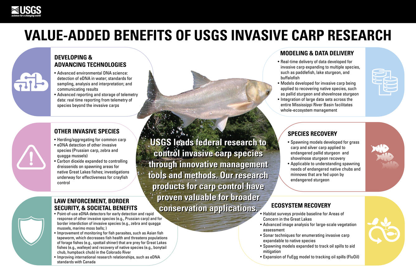
Invasive Carp in the Mississippi River Basin
Bighead, black, grass, and silver carp (invasive carp) escaped into the Mississippi River in the early 1980s. If invasive carp were to enter the Great Lakes they would threaten a \$5.1 billion fishery and the boating industry, which supports 244,000 jobs, \$19 billion in boating sales, \$6.4 billion in personal income, and \$9.2 billion in value added goods and services. USGS science provides the foundation for developing deterrents, pesticides, predictive models for where they spawn, mass harvest techniques and means of evaluating when, where, and how to remove invasive carp to reduce populations where they exist and to prevent them from entering the Great Lakes. Containing invasive carp and reducing their further spread is a goal shared by federal and state natural resource managers, particularly in preventing spread to the Great Lakes. A major part the USGS research on invasive carp has been on using carbon dioxide and underwater sound to develop behavioral deterrents for invasive carp. These technologies are ready to be transferred to managers and are slated to be added to the Brandon Road Interbasin Project. The USGS also works with partners to deliver real-time data to managers and share data across the Mississippi River Basin.

Sea Lamprey in the Great Lakes
The parasitic sea lamprey invaded the Great Lakes in the mid-20th century, devastating valuable native fisheries and coastal economies, valued at \$5.6 billion. The USGS plays a central role in sea lamprey control research by working with the Great Lakes Fishery Commission and State, Federal, and Tribal agencies, and academic institutions to provide science on sea lamprey biology, ecology, and control technologies. The USGS developed a novel trap and electrical-guidance array that can remove 75 percent of invasive sea lamprey from a stream with minimal impacts to nontarget species and stream flow. In addition, USGS scientists registered with the U.S. Environmental Protection Agency the first vertebrate pheromone, which when applied, can increase sea lamprey trap catch by 35 percent.
Surveillance of Invasive Species
The USGS Flood and Storm Tracker of the USGS Nonindigenous Aquatic Species (NAS) database is used by municipalities and resource managers to target surveillance and rapid response actions in areas most likely to be invaded by aquatic invasive species in flood and storms events during a natural disaster. The NAS team has created 20 maps since 2017, using records for more than 1400 non-native aquatic plants and animals as well as storm tide heights, water level, and water flow data collected USGS water scientists during the storms. For example, the preliminary Flood and Storm Tracker map for Hurricane Helene in 2024 indicated 222 possible non-native species had the potential to spread due to storm-related flooding. Many of the records in the NAS database are submitted by citizen scientists; in 2021, a citizen reported an invasive zebra mussel found in an aquarium moss package in a pet store. USGS initiated a nationwide response, pulling together federal, state, and industry partners, which led to the discovery and removal of the invasive species in pet stores in at least 21 stories.
IMAGE: Screenshot of USGS FaST map showing potential spread of alligatorweed to new locations following Hurricane Helene.

Early Detection and Rapid Response of Invasive Species
With the recorded total costs of invasives species estimated at \$1.22 trillion, prevention is the first line of defense. However, even the best prevention efforts will not stop all invaders. When prevention fails, Early Detection and Rapid Response (EDRR) is an efficient and cost-effective part of invasive species management. Under a new National EDRR Framework, the USGS is expanding scientific support to DOI bureaus and other partners to aid in implementation of EDRR efforts and make informed management actions. For example, USGS scientists are developing tools to enhance detection of environmental DNA for invasive mussels, introduced ants, and many other species. The USGS is aiding the development of a surveillance network that includes use of large sets of traditional sampling and eDNA data to evaluate “hotspots” of invasive species introduction vulnerability. USGS led the creation of SIREN, an information management system to support EDRR decision making.
IMAGE: eDNA autosampler is programmed to collect and filter water samples for eDNA analysis every 3 hours on Cherry Creek, MT

Contaminants
Approximately 60 million Americans live in rural areas and rarely know the quality of their drinking water at the tap, which are often from onsite wells, which are not regulated, and treatment is entirely the responsibility of the homeowner. Additionally, approximately 240 million Americans who live in urban and suburban areas utilize water from municipal facilities that is tested regularly for a limited number of chemicals at the point of distribution within the facility. USGS provides information about the processes driving contaminants and pathogens from their sources through aquifers, watersheds, drinking water facilities, and aging distribution infrastructure to homes, and by monitoring complex mixtures of over 400 chemicals and pathogens where human exposure occurs— at the tap.

PFAS
Increasing scientific and public awareness of the widespread distribution of per- and polyfluoroalkyl substances (PFAS) in U.S. drinking-water supplies, aquatic and terrestrial ecosystems, wildlife, and humans has raised many public health and resource management questions. One report by the Centers for Disease Control and Prevention found PFAS in the blood of 97% of Americans. The lasting health impacts of PFAS are difficult to quantify and cost estimates for PFAS treatment and clean-up are estimated to be in the trillions of U.S. dollars. The USGS is actively addressing PFAS contamination and its implications nationwide. The USGS has recently developed the PFAS in Groundwater Interactive Dashboard that presents the probability of occurrence of PFAS in groundwater at the depths of both public and private drinking water supply for the lower 48 States of the U.S. This dashboard has had over 33,000 views within 2 months and updated with new results as they are made available. A second dashboard, the PFAS in Drinking Water Interactive Dashboard was developed to visualize PFAS measurements for tap water samples collected at 716 private and public supplies, nationwide. This dashboard is updated regularly. In the past 1.5 years, this dashboard has been viewed over 32,000 times.

Harmful Algal Blooms
Harmful algal blooms (HABs) can have considerable recreational and economic impacts, disrupting activities like fishing and swimming while also affecting property values. In 2018, USGS estimated a HAB event bloom in Florida resulted in \$5.5 million in lost recreational opportunities and \$2.3 million in potential losses in housing sale prices. The USGS is working on improving methods to measure algal blooms and the toxins they produce, as well as understanding the factors that impact the severity of these blooms and toxin production.
- USGS is evaluating various exposure routes and the potential effects on humans, animals, and aquatic species, developing much needed early warning tools to assist water and land managers and health organizations to avoid and minimize human exposure to HABs. For example, the USGS worked with other federal agencies to support Cyanobacteria Assessment Network (CyAN), a web-based tool utilizing satellite data to identify when HABs blooms may be forming. This early warning tool was designed to help federal, state, tribal, and local partners and allows users to access, download, and provide data to notify users based on specific changes in the color of the water and the possible onset of HABs in more than 2,000 of the largest lakes and reservoirs across the U.S. This innovative system provides a warning up to 2 days earlier than traditional methods, significantly enhancing public health protection against cyanotoxin exposure. For the State of Kansas, the economic value of CyAN is estimated to range between \$565,000 and \$2.3 million annually, underscoring the tool's importance in safeguarding community well-being and supporting informed decision-making regarding water safety.
- Deadly paralytic shellfish poisoning (PSP) toxin proliferates during HABs events off the coast of Alaska. This toxin contaminates locally harvested shellfish, causing paralysis and death if consumed and necessitating costly commercial monitoring. The USGS partnered with the Chugach Regional Resources Commission to form a Tribal harmful algal bloom monitoring network to look for “early warnings” of harmful algal bloom events. This will inform subsistence harvesters, resource managers, and researchers of PSP risk levels at key shellfish harvest sites and will be used to develop subsistence shellfish harvest management plans.
Reducing the Impacts of Contaminants and Pathogens
USGS scientists provide information on toxicants and pathogens that could originate from the growing, raising, and processing/manufacturing of plant and animal products through the environment where exposure can occur. This information is used to understand if there are adverse effects upon exposure and to develop decision tools to protect health.
- Chemical contaminants including pesticides, fertilizers, and heavy metals that may accumulate in soil and water, impacting plant growth and food quality. There are an estimated 5,823,00 dry metric tons of biosolids generated annually in the U.S. Roughly 53% is disposed of via application to farmland at a cost of \$62/ton and USGS research on the composition of this material and influence on agriculture soils, waters used for irrigation or drinking, and food products supports the safe use of biosolids in food production.
- Foodborne illness outbreaks can have significant economic implications for individuals, businesses, and the healthcare system. According to estimates, approximately \$17.6 billion in economic burden is associated with pathogens. Research conducted by USGS investigates the occurrence of pathogens and other contaminants in the environment that could pose risks to food supplies.
- In the \$5.1 billion Great Lakes fishery, USGS science is supporting sustainable fisheries important to DOI, state, and tribal fishery managers, while reducing impacts of invasive species and aquatic pathogens.

Artificial Intelligence in the USGS Ecosystems Mission Area

Economics of Wildland Fire

Key Values of a Century of EESC Science

Helping Secure Our Nation’s Food Supply: The Intersection of Agriculture, Health, and Environment

SBSC: Providing Unbiased Actionable Science & Information to Support Natural Resource Management Needs of the U.S. & Department of the Interior Priorities
Reducing Wildfire Risks with Science

WARC Science in the Gulf of America

Invasive Species We Study: Invasive Carp

Environmental Health: Science to Support Natural Resource Use

Decoding Harmful Algal Blooms: Unraveling the Mystery

Discovering Connections Across America's Lands and Waters
USGS science developed by the Ecosystems Mission Area helps ensure safe and abundant domestic food and water supplies, ensuring all Americans access to livelihoods and traditions that connect generations with each other and the outdoors and strengthen America’s self-reliance. USGS science is used by decision makers at all levels to understand how the quality of America’s food supply is directly connected to the health of America’s lands and water assets, and the fish and wildlife they support.
USGS Ecosystems Science in Support of Economic Growth
Science provided by the USGS Ecosystems Mission Area helps boost America’s economy by providing practical tools to implement cost-effective management and development strategies that supports the Nation’s economic growth and protects our natural heritage.
USGS Ecosystems Science in Support of Public Safety & Security
Science within the USGS Ecosystems Mission Area provides a critical advantage in addressing public safety, infrastructure, and security issues surrounding natural disasters and changing landscapes, strengthening America’s ability to be a hazard ready Nation.
Agriculture
USGS is working with the agricultural industry to identify processes that support a healthy food supply for American consumption including the health of pollinator populations across the Nation. Scientists also assess the risks to those food supplies such as wildlife disease (more than three quarters of livestock diseases are shared with wildlife), chemicals, pathogens, and antibiotic-resistant organisms in the environment. The USGS is on the front lines as the lead federal agency for wildlife disease surveillance and research. USGS scientists are also providing valuable data and decision support tools to farmers and ranchers to help respond to and mitigate costly impacts on agricultural production such as drought and invasive species.
Mitigating Avian Influenza Outbreaks
USGS conducts critical research on highly pathogenic avian influenza, a significant threat to humans, wildlife, domestic poultry, and the agricultural industry. USGS scientists monitor and study avian influenza viruses in wild bird populations, and identify transmission pathways and environmental factors influencing outbreaks and potential risks to commercial poultry operations. This work includes disease surveillance, genetic characterization of viruses, and evaluating the role of migratory birds in spreading highly pathogenic avian influenza (HPAI). By leveraging USGS scientific expertise and partnerships, the USGS plays an essential role in addressing HPAI threats, ensuring sustainable agriculture while protecting public health and biodiversity. This research underscores the value of USGS science in solving challenges with direct economic and societal impacts.
- The findings inform early warning systems and management strategies to mitigate disease outbreaks, helping safeguard over 2 million jobs, \$130 billion in wages, \$660 billion in economic activity and \$54 billion in government revenue from devastating economic losses.
- USGS research also supports agricultural biosecurity by advising policymakers and industry stakeholders on effective preventive measures, such as risk assessment for poultry farms near migratory bird habitats. The high value of this research lies in its ability to reduce disease transmission risks, maintain food security, and protect livelihoods dependent on agriculture.
- USGS used surveillance data from wild birds, environmental reservoirs of the virus, and knowledge of wild bird movement patterns to identify poultry and dairy farms vulnerable to avian influenza infection and is critical to the agricultural sector for cost-effective preparedness and are necessary for strategies to contain outbreaks before they reach the continental United States.
Informing Economical Rangeland Management
USGS science supports the management of rangelands, which generate over \$2 billion in economic output and 32,000 jobs. In 2022, sustainable rangeland management in 11 western states, guided by USGS science, supported approximately \$2.5 billion in beef and veal state export estimates and approximately \$185 million in state export estimates of hides and skins.
- USGS cheatgrass research helps to reduce landscape-scale impacts in the western U.S. In Wyoming alone, cheatgrass infestation reduced the value of agricultural cash rents by an estimated \$32.1 million in 2021. This translates to a direct reduction in landowners’ household income as well as related induced losses from foregone household-to-business spending, including 149 annual jobs, \$6.6 million in labor income, \$13.0 million in value added, and \$24.1 million in output. USGS science informs strategies and approaches for fuels management and herbicide application for invasive grasses that reduces the burn probability that may reduce costs for fire suppression, which costs over $4 billion annually.
- There are approximately 770 million acres of range and pastureland in the U.S., with about 360 million of those being public lands. Many ranchers have an interest in diversifying their incomes streams while still ranching cattle and USGS science is helping some of them do just that. USGS science provides ranchers in the western U.S. with information and decision support to manage drylands to receive carbon payments, which produces value for the economy. This also supports the decarbonizing the West initiative led by the Western Governors Association. Many U.S. ranchers are currently being paid by companies to manage for carbon (including with carbon sequestration) on public lands where they graze their livestock. Price per metric ton tends to be around \$16-20 which means that USGS science could be helping ranchers access as much as an additional over \$7 billion in revenue on public lands alone. USGS scientists are working side-by-side with U.S. ranchers in local and regional communities to better quantify, map, and provide management options for them to receive carbon economic benefits. Also, because the increase of organic carbon in soils has several co-benefits that result in increased plant and forage amount and quality, soil fertility, and the ability of soil to hold water, as well as reduced erosion, the science can help support further value for the economy through its support of practices that improve forage amount and quality for livestock.
Informing Drought Adaptation Strategies
Drought has far-reaching economic and health impacts for people, the agriculture industry, and natural resources. USGS scientists are strengthening drought-monitoring networks by combining historical data with real-time information to forecast future water availability.
- Many drylands in the west are managed for domestic livestock grazing and recreation, which generates billions of dollars of revenue for the federal government and contributes hundreds of millions of dollars to local communities. USGS scientists work with both private ranchers and federal partners – including the Bureau of Land Management and National Park Service – to develop strategies to help land managers adapt to drought and invasive species. USGS research informs DOI managers and ranchers on how the most deleterious impacts of drought and invasives can be avoided through management and restoration. Experiments to understand how forage timing, quality, and quantity are expected to shift in the future, and how threats from invasive plants can be mitigated through proper weed control tactics and landscape restoration are key. This research allows local ranchers to make informed planning decisions about current and future livestock stocking rates and supports economic well-being by helping them make the right investments for future productivity to save money.
- With the Bureau of Reclamation and the Montana Department of Natural Resources and Conservation, USGS scientists reconstructed the Missouri River basin’s hydrologic history going back 1,200 years to determine the extent to which temperature and precipitation influence drought risk and water reliability. This information was then used to predict future drought risk at important management locations throughout the basin, providing a roadmap for future water management strategies under changing water supply conditions.
Supporting Pollinators
Pollinators are invaluable when it comes to national food security and the agricultural economy for local communities by suppressing pest insects, pollinating plants, and spreading seeds. USGS pollinator research helps maintain \$18 billion in pollinator services, which are essential for U.S. agriculture and food security.
- The U.S. Northern Plains support more than one million honeybee colonies which are annually shipped across the country to pollinate crops and provide food security. In 2024, honeybees in the region produced one third of the Nation’s \$377 million honey crop. USGS science has produced ecological information that beekeepers can use to maximize their profits. USGS studies reported that honeybee apiaries surrounded by agriculture crops in which the bees do not forage (low quality) resulted in smaller colonies by the end of the growing season than apiaries set up next to less agriculture and more grasslands (high quality). This could have economic implications; for example, 200 high-quality apiaries could net the operator an additional \$4,100 in colony rentals per apiary worth an additional \$820,000 annually compared to 200 low-end apiaries.
Mitigating the Spread of White-nose Syndrome
White nose syndrome (WNS), a fungal disease that is a major threat to North American bat species. Bat species provide important insect control services to agriculture. USGS scientists and partners found that by naturally suppressing crop pests through predation, bats save U.S. farmers at least $3.7 billion annually (e.g., little brown bats weigh about half an ounce but can eat 1,000 mosquitoes/hour). WNS could result in significant economic losses in the agriculture sector. For example, in south-central Texas an analysis of economic benefits of pest control by bats suggests they provide $74 per acre of private and societal benefits. USGS discovered, characterized, and named the fungus that causes WNS, and developed standard criteria for diagnosing the disease. USGS coordinates a national effort to monitor bat populations and is investigating treatments to slow or halt additional spread of WNS.
Efficient Salmon Monitoring
The 2024 commercial salmon fishery harvest for all species in Alaska was valued at approximately $304 million. By collecting water samples and analyzing traces of DNA left behind by the salmon as they swim upstream, USGS-supported researchers can gather information about salmon abundance without needing to directly observe or handle the fish. Analyzing environmental DNA (eDNA) has the potential to save time and labor and provide a more cost-effective way to monitor salmon in remote locations where there is no established monitoring equipment.
Informing Aquaculture
The northern hard clam, a type of Quahog clam, is an extensively fished and farmed species of shellfish that is eaten both raw and processed into clam chowder. It is the main shellfish aquaculture species of Florida, and in 2020 brought in $14.3 million in sales. The USGS is working with the University of South Florida and the Gulf Shellfish Institute to improve understanding of hard clam populations in Tampa Bay. Researchers are looking at how water chemistry and water temperature affect shell growth and survival, so that managers and the aquaculture industry can understand threats to past, present, and future quahog populations. This information is invaluable to the aquaculture industries, since changing habitat conditions may impose an ecological regime shift across the Gulf Coast region.
Fishing and Hunting
In 2022, 39.9 million people fished and 14.4 million hunted, spending \$144.6 billion in total on fishing and hunting activities. The USGS is providing key insights about optimal management of wildlife species including different harvest strategies to determine which ones would lead to the highest expected net benefits, cost-efficient game and fish monitoring strategies, cost-effective habitat management, customized plans for disease surveillance and harvest strategies.
Healthy Sportfish Populations and Sustainable Fishing
USGS science helps ensure that sportfishing remains strong for the American people by delivering science that supports healthy sportfish populations and sustainable fishing. USGS scientists provide state, Tribal, and federal partners with tools such as environmental DNA, habitat modeling, and fish health diagnostics to monitor populations, identify threats, and respond to changes in water, habitat, and the environment.
USGS has developed a partnership with four interstate fisheries commissions to strengthen delivery of science to resource managers for recreational and commercial fisheries in the Pacific, Atlantic, Gulf, and Great Lakes. This work improves efficiency of research and provides opportunities to work directly with resource managers to supply information.
In North Dakota, fishing generates hundreds of millions of dollars a year. For highly sought-after sportfish such as Yellow Perch and Walleye, water-level changes can have important impacts on their populations. USGS scientists partnering with the North Dakota Fish and Game Department found that when the surface area of Devils Lake, ND increased 240% from 1992-2013, there was a 500% increase in annual angler effort during that same time period. These changes can have economic consequences for surrounding communities for whom angler expenditures are vital. Their methods could also help reduce dependence on the use of expensive and logistically challenging traditional creel surveys for understanding angler effort.
In Montana, fisheries are valued at more than \$900 million per year. Partnering with Montana Fish, Wildlife & Parks, USGS scientists found that the continued loss of trout habitat due to warming waters could result in a loss of nearly \$200 million per year in angling revenue in Montana, or about 30% of its current trout fishing economy. In Alaska, USGS economists have used permit data to estimate demand and values for personal use salmon fishing. The work explores how daily conditions, including weather, sizes of salmon runs, and commercial fishery operation, affect demand.
USGS fish health science underpins management of 80% of salmon fisheries in the West and supports healthy fish populations across the nation for ~40M anglers that invest \$99.4B into the economy. Work from USGS is helping identify the cause of a 2024 crash in Yukon River wild Chinook salmon populations that led to a 7-year moratorium on harvest. Scientists with expertise in disease, physiology, nutrition, and reproduction of salmon are collaborating to identify how overlapping factors may contribute to poor fish stocks, supporting resource managers to improve opportunities for harvest in the future.
Big Game Science
White-tailed deer, mule deer, elk, and moose are central to our country’s big game hunting heritage, with 11.5 million hunters taking 92 million trips and spending 135 million hunter days annually in pursuit of big game. Big game hunting contributes to annual hunter expenditures of \$45.2 billion, a substantial proportion of which supports local economies. Hunting-related funds provide the largest single revenue source for many state natural resource management agencies. Additionally, the captive herd farming industry generates \$7.9 billion in annual economic activity and supports tens of thousands of jobs.
- Chronic Wasting Disease (CWD) has been documented in wild populations in 36 states, and in captive cervid facilities in 22 states and is a leading threat to free-ranging and captive deer populations and the hunting heritage and industries they support. CWD outbreaks impact state hunting and decrease revenues generated by hunting. USGS provides early warning about the possible spread of CWD and strategies to mitigate outbreaks, help States continue to generate revenue from hunting licenses. There are only a limited number of supported ways to manage CWD, creating a challenging decision-making environment where stakeholder preferences must be weighed against available management actions. USGS social scientists have engaged with the CWD management community to more efficiently manage the disease and support difficult decisions. A recent study with USGS scientists showed that removing high numbers of male mule deer reduced the prevalence of CWD in herds.
- USGS scientists and their cooperators work together to understand how large-scale migration patterns may affect big-game, hunter satisfaction, and land-use planning across the western United States. States are readily incorporating USGS big-game migration maps into their own management, conservation planning, or outreach by using the migration maps to identify crossing structures. The U.S. Department of Agriculture has now fully stood up its Migratory Big Game Initiative, which is bringing millions in Farm Bill funding to conserve the private ranchlands that underpin the mapped migrations in Idaho, Montana, and Wyoming. The Bridger-Teton National Forest is incorporating the mapped migrations on into their upcoming Forest Plan revision. The USGS is also studying how big game species like mule deer are at risk due to more frequent and intense droughts that limit access to food during migration by identifying migration corridor habitat that can help mule deer withstand the effects of drought by ensuring freedom of movement to access needed resources.
Supporting the Recreational Waterfowl Industry
Waterfowl in North America provide value in recreation, including bird watching and hunting, and subsistence harvest. In 2023, there was an estimated 1.3 million waterfowl hunters contributing to local economies across America.
- USGS scientists in collaboration with their partners from USFWS have developed techniques to improve efficiency in the management of waterfowl in North America. The rigorous process developed by the team helps natural resource managers implement decisions that maximize hunting opportunities now and in the future. This adaptive management process has been in place for decades and continues to be improved, allowing managers to make optimal decisions in the face of large uncertainty. It has inspired other countries to use a similar process to improve management efficiency.
- USGS science found that if the number of waterfowl were doubled, economic expenditures in the Mississippi Flyway would also double with potentially \$2.9 billion spent annually. However, even a small loss of waterfowl could result in the loss of \$20 million.
- USGS is providing North American Waterfowl Management Plan partners a better understanding of how recreational hunters participate and benefit from waterfowl and migratory birds including how to better support new participants, and the range of preferences existing participants hold.
Invasive Species
Between 1969 and 2020, the recorded total costs of invasives species were \$1.22 trillion and the annual estimated economic and health-related costs of invasive species in the U.S. have been reported at more than \$21 billion. The impacts of invasive species include decreased agricultural production, competition with and predation on native plants and wildlife, impairment of critical water infrastructure, transmission of disease to wildlife and humans, threats to commercial and native fisheries, and reduced hunting, fishing, and other recreational opportunities such as boating and swimming. USGS leads in research and science support to fight invasive species by harnessing scientific expertise to inform treatment methods, locations, effort, and timing by the integration of ecological models with economic tools. Preventing new invasions is the most effective strategy to avoid impacts, and USGS scientists work on tools to stop new introductions to the U.S. (such as global risk assessments) and minimize spread within U.S. borders.
Invasive Carp in the Mississippi River Basin
Bighead, black, grass, and silver carp (invasive carp) escaped into the Mississippi River in the early 1980s. If invasive carp were to enter the Great Lakes they would threaten a \$5.1 billion fishery and the boating industry, which supports 244,000 jobs, \$19 billion in boating sales, \$6.4 billion in personal income, and \$9.2 billion in value added goods and services. USGS science provides the foundation for developing deterrents, pesticides, predictive models for where they spawn, mass harvest techniques and means of evaluating when, where, and how to remove invasive carp to reduce populations where they exist and to prevent them from entering the Great Lakes. Containing invasive carp and reducing their further spread is a goal shared by federal and state natural resource managers, particularly in preventing spread to the Great Lakes. A major part the USGS research on invasive carp has been on using carbon dioxide and underwater sound to develop behavioral deterrents for invasive carp. These technologies are ready to be transferred to managers and are slated to be added to the Brandon Road Interbasin Project. The USGS also works with partners to deliver real-time data to managers and share data across the Mississippi River Basin.
Sea Lamprey in the Great Lakes
The parasitic sea lamprey invaded the Great Lakes in the mid-20th century, devastating valuable native fisheries and coastal economies, valued at \$5.6 billion. The USGS plays a central role in sea lamprey control research by working with the Great Lakes Fishery Commission and State, Federal, and Tribal agencies, and academic institutions to provide science on sea lamprey biology, ecology, and control technologies. The USGS developed a novel trap and electrical-guidance array that can remove 75 percent of invasive sea lamprey from a stream with minimal impacts to nontarget species and stream flow. In addition, USGS scientists registered with the U.S. Environmental Protection Agency the first vertebrate pheromone, which when applied, can increase sea lamprey trap catch by 35 percent.
Surveillance of Invasive Species
The USGS Flood and Storm Tracker of the USGS Nonindigenous Aquatic Species (NAS) database is used by municipalities and resource managers to target surveillance and rapid response actions in areas most likely to be invaded by aquatic invasive species in flood and storms events during a natural disaster. The NAS team has created 20 maps since 2017, using records for more than 1400 non-native aquatic plants and animals as well as storm tide heights, water level, and water flow data collected USGS water scientists during the storms. For example, the preliminary Flood and Storm Tracker map for Hurricane Helene in 2024 indicated 222 possible non-native species had the potential to spread due to storm-related flooding. Many of the records in the NAS database are submitted by citizen scientists; in 2021, a citizen reported an invasive zebra mussel found in an aquarium moss package in a pet store. USGS initiated a nationwide response, pulling together federal, state, and industry partners, which led to the discovery and removal of the invasive species in pet stores in at least 21 stories.
IMAGE: Screenshot of USGS FaST map showing potential spread of alligatorweed to new locations following Hurricane Helene.
Early Detection and Rapid Response of Invasive Species
With the recorded total costs of invasives species estimated at \$1.22 trillion, prevention is the first line of defense. However, even the best prevention efforts will not stop all invaders. When prevention fails, Early Detection and Rapid Response (EDRR) is an efficient and cost-effective part of invasive species management. Under a new National EDRR Framework, the USGS is expanding scientific support to DOI bureaus and other partners to aid in implementation of EDRR efforts and make informed management actions. For example, USGS scientists are developing tools to enhance detection of environmental DNA for invasive mussels, introduced ants, and many other species. The USGS is aiding the development of a surveillance network that includes use of large sets of traditional sampling and eDNA data to evaluate “hotspots” of invasive species introduction vulnerability. USGS led the creation of SIREN, an information management system to support EDRR decision making.
IMAGE: eDNA autosampler is programmed to collect and filter water samples for eDNA analysis every 3 hours on Cherry Creek, MT
Contaminants
Approximately 60 million Americans live in rural areas and rarely know the quality of their drinking water at the tap, which are often from onsite wells, which are not regulated, and treatment is entirely the responsibility of the homeowner. Additionally, approximately 240 million Americans who live in urban and suburban areas utilize water from municipal facilities that is tested regularly for a limited number of chemicals at the point of distribution within the facility. USGS provides information about the processes driving contaminants and pathogens from their sources through aquifers, watersheds, drinking water facilities, and aging distribution infrastructure to homes, and by monitoring complex mixtures of over 400 chemicals and pathogens where human exposure occurs— at the tap.
PFAS
Increasing scientific and public awareness of the widespread distribution of per- and polyfluoroalkyl substances (PFAS) in U.S. drinking-water supplies, aquatic and terrestrial ecosystems, wildlife, and humans has raised many public health and resource management questions. One report by the Centers for Disease Control and Prevention found PFAS in the blood of 97% of Americans. The lasting health impacts of PFAS are difficult to quantify and cost estimates for PFAS treatment and clean-up are estimated to be in the trillions of U.S. dollars. The USGS is actively addressing PFAS contamination and its implications nationwide. The USGS has recently developed the PFAS in Groundwater Interactive Dashboard that presents the probability of occurrence of PFAS in groundwater at the depths of both public and private drinking water supply for the lower 48 States of the U.S. This dashboard has had over 33,000 views within 2 months and updated with new results as they are made available. A second dashboard, the PFAS in Drinking Water Interactive Dashboard was developed to visualize PFAS measurements for tap water samples collected at 716 private and public supplies, nationwide. This dashboard is updated regularly. In the past 1.5 years, this dashboard has been viewed over 32,000 times.
Harmful Algal Blooms
Harmful algal blooms (HABs) can have considerable recreational and economic impacts, disrupting activities like fishing and swimming while also affecting property values. In 2018, USGS estimated a HAB event bloom in Florida resulted in \$5.5 million in lost recreational opportunities and \$2.3 million in potential losses in housing sale prices. The USGS is working on improving methods to measure algal blooms and the toxins they produce, as well as understanding the factors that impact the severity of these blooms and toxin production.
- USGS is evaluating various exposure routes and the potential effects on humans, animals, and aquatic species, developing much needed early warning tools to assist water and land managers and health organizations to avoid and minimize human exposure to HABs. For example, the USGS worked with other federal agencies to support Cyanobacteria Assessment Network (CyAN), a web-based tool utilizing satellite data to identify when HABs blooms may be forming. This early warning tool was designed to help federal, state, tribal, and local partners and allows users to access, download, and provide data to notify users based on specific changes in the color of the water and the possible onset of HABs in more than 2,000 of the largest lakes and reservoirs across the U.S. This innovative system provides a warning up to 2 days earlier than traditional methods, significantly enhancing public health protection against cyanotoxin exposure. For the State of Kansas, the economic value of CyAN is estimated to range between \$565,000 and \$2.3 million annually, underscoring the tool's importance in safeguarding community well-being and supporting informed decision-making regarding water safety.
- Deadly paralytic shellfish poisoning (PSP) toxin proliferates during HABs events off the coast of Alaska. This toxin contaminates locally harvested shellfish, causing paralysis and death if consumed and necessitating costly commercial monitoring. The USGS partnered with the Chugach Regional Resources Commission to form a Tribal harmful algal bloom monitoring network to look for “early warnings” of harmful algal bloom events. This will inform subsistence harvesters, resource managers, and researchers of PSP risk levels at key shellfish harvest sites and will be used to develop subsistence shellfish harvest management plans.
Reducing the Impacts of Contaminants and Pathogens
USGS scientists provide information on toxicants and pathogens that could originate from the growing, raising, and processing/manufacturing of plant and animal products through the environment where exposure can occur. This information is used to understand if there are adverse effects upon exposure and to develop decision tools to protect health.
- Chemical contaminants including pesticides, fertilizers, and heavy metals that may accumulate in soil and water, impacting plant growth and food quality. There are an estimated 5,823,00 dry metric tons of biosolids generated annually in the U.S. Roughly 53% is disposed of via application to farmland at a cost of \$62/ton and USGS research on the composition of this material and influence on agriculture soils, waters used for irrigation or drinking, and food products supports the safe use of biosolids in food production.
- Foodborne illness outbreaks can have significant economic implications for individuals, businesses, and the healthcare system. According to estimates, approximately \$17.6 billion in economic burden is associated with pathogens. Research conducted by USGS investigates the occurrence of pathogens and other contaminants in the environment that could pose risks to food supplies.
- In the \$5.1 billion Great Lakes fishery, USGS science is supporting sustainable fisheries important to DOI, state, and tribal fishery managers, while reducing impacts of invasive species and aquatic pathogens.
Artificial Intelligence in the USGS Ecosystems Mission Area
Economics of Wildland Fire
Key Values of a Century of EESC Science
Helping Secure Our Nation’s Food Supply: The Intersection of Agriculture, Health, and Environment
SBSC: Providing Unbiased Actionable Science & Information to Support Natural Resource Management Needs of the U.S. & Department of the Interior Priorities
Reducing Wildfire Risks with Science
WARC Science in the Gulf of America
Invasive Species We Study: Invasive Carp
Environmental Health: Science to Support Natural Resource Use
Decoding Harmful Algal Blooms: Unraveling the Mystery