Addressing Natural Hazards with Reliable Science
The USGS has critical roles regarding floods, earthquakes, tsunamis, landslides, coastal erosion, volcanic eruptions, wildfires, magnetic storms, and many other threats. Our research provides people with a better understanding of natural hazards and ways to reduce avoidable risks. Founded on detailed observations of Earth’s physical processes, researchers deliver valuable scientific information, such as frequency, magnitude, extent, onset, consequences, and where possible, the time of future hazardous events.
The USGS maintains an expert workforce of scientists and technicians in the earth sciences, hydrology, biology, geography, social and behavioral sciences, and other fields. Our researchers work cooperatively with numerous agencies, research institutions, and organizations in the public and private sectors, across the Nation and worldwide.
Hazard science is used by decision makers to determine whether risk management activities are worthwhile. Moreover, as an agency with the perspective of geologic time, the USGS is uniquely positioned to extend the collective experience of society to prepare for events outside current memory.
Here are a few examples of USGS research focusing on threats in the natural world.


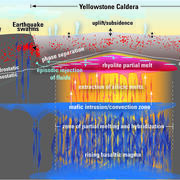
 Yellowstone Volcano")
")