
Advanced Capabilities and Research
Advanced Capabilities and Research
USGS Rapid Deployment Gages (RDGs)
Integration of sUAS into Hydrogeophysical Studies
Binational SPARROW nutrient modeling
A joint USGS and Canadian effort to model phosphorus and nitrogen transport
A joint USGS and Canadian effort to model phosphorus and nitrogen transport
Our most advanced science supporting our mission to provide water-resource monitoring, assessment, modeling, and research to provide information and tools that managers and policymakers can use.
Hydrologic Instrumentation Facility (HIF)
Hydrologic Instrumentation Facility (HIF)

The HIF provides quality hydrologic equipment and instrumentation
Filter Total Items: 112

MODFLOW and Related Programs
MODFLOW is the USGS's modular hydrologic model. MODFLOW is considered an international standard for simulating and predicting groundwater conditions and groundwater/surface-water interactions. MODFLOW 6 is presently the core MODFLOW version distributed by the USGS.

Groundwater-Level Response to Earthquakes
Did you know that earthquakes can cause changes in groundwater levels? Very large earthquakes can even cause water-level fluctuations in some wells thousands of miles away, depending on the local geological conditions around the well.

Karst Aquifers
Karst terrain is created from the dissolution of soluble rocks, principally limestone and dolomite. Karst areas are characterized by distinctive landforms (like springs, caves, sinkholes) and a unique hydrogeology that results in aquifers that are highly productive but extremely vulnerable to contamination.

Integrated Water Science (IWS) Basins
The U.S. Geological Survey is integrating its water science programs to better address the Nation’s greatest water resource challenges. At the heart of this effort are plans to intensively study several Integrated Water Science (IWS) basins—medium-sized watersheds (10,000-20,000 square miles) and underlying aquifers—over the next decade. The IWS basins will represent a wide range of environmental...

Next Generation Water Observing System (NGWOS)
The Next Generation Water Observing System (NGWOS) supports water availability assessments, management, and prediction by enhancing water observations in basins that represent major U.S. hydrologic regions. NGWOS provides high-resolution, real-time data on water quantity, quality, and use, as well as advance the development and application of new sensor technologies and remote sensing methods.

Next Generation Water Observing System: Illinois River Basin
The Next Generation Water Observing System provides high-fidelity, real-time data on water quantity, quality, and use to support modern water prediction and decision-support systems that are necessary for informing water operations on a daily basis and decision-making during water emergencies. The Illinois River Basin provides an opportunity to implement the NGWOS in a system challenged by an...

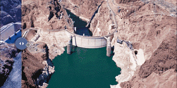
Next Generation Water Observing System: Upper Colorado River Basin
The Next Generation Water Observing System (NGWOS) provides high-fidelity, real-time data on water quantity, quality, and use to support modern prediction and decision-support systems that are necessary for informing water operations on a daily basis and decision-making during water emergencies. The headwaters of the Colorado and Gunnison River Basins provide an opportunity to implement NGWOS in a...

Next Generation Water Observing System: Delaware River Basin
The Next Generation Water Observing System (NGWOS) supports water availability assessments, management, and prediction by enhancing water observations in basins that represent major U.S. hydrologic regions. The Delaware River Basin was the first Integrated Water Science basin selected, providing an opportunity to implement the NGWOS program in a nationally important, complex interstate river...

Principal Aquifers of the United States
This website compiles USGS resources and data related to principal aquifers including Aquifer Basics, principal aquifers maps and GIS data, and the National Aquifer Code Reference List.

Flood Frequency Reports
Flood-frequency analysis provides information about the magnitude and frequency of floods based on records of annual maximum instantaneous peak discharges. Accurate flood-frequency estimates, created using consistent and uniformly applied methods, are a key component of any effective flood risk and management program. This is a list of current USGS flood frequency reports published by state.

Hydrologic Instrumentation Facility (HIF)
The USGS Hydrologic Instrumentation Facility (HIF) supports the water-resource monitoring efforts of USGS scientists and other Federal scientists by providing quality-assured hydrologic equipment and instrumentation support.

Atmospheric Warming, Loss of Snow Cover, and Declining Colorado River Flow
Declining snow cover is playing a key role in decreasing the flow of the Colorado River, “the lifeblood of the Southwest,” by enabling increased evaporation. As the warming continues, increasingly severe water shortages are expected.