
Buildings destroyed during Hurricane Maria in Rincón, Puerto Rico. Photograph taken on August 28, 2021, almost four years after the hurricane.
Coastal Hazards and Resilience
Coastal hazards such as hurricanes, sea-level rise, flooding, erosion, and extreme storms can threaten lives and health, property, and valuable habitats along our nation’s coasts. USGS science, products, and tools provide the Nation with robust and accessible scientific research to help partners anticipate, prepare for, adapt to, and mitigate coastal hazards.
While coastal change is natural, hazards arise when these changes threaten lives or put communities and habitats at risk. Some of these hazards can occur abruptly such as earthquakes, landslides, and tsunamis; or within short periods of time such as hurricanes and extreme storms. Others happen gradually over time like sea-level rise, erosion, or saltwater intrusion into groundwater. The USGS is a leader in natural hazards research and addresses coastal hazards by conducting basic and applied research, developing tools to assess risk, and providing data and information to stakeholders and partners to enhance preparedness.
Tools and Technology for Coastal Resilience
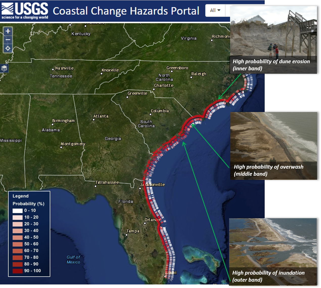
The USGS collection of coastal tools provides information on coastal hazards at scales useful for local communities, regional managers, and decision makers. For example, the USGS Coastal Change Hazards Portal allows users to explore the potential for storm-induced coastal erosion, forecasts of extreme water levels, historical shoreline change, and vulnerability to sea-level rise. These data and products are immensely valuable for assisting communities with efforts to bolster coastal resilience and reduce vulnerability to coastal hazards.


Sources/Usage: Public Domain. View Media Details
Media

Sources/Usage: Public Domain. View Media Details
Hurricane Response
Hurricanes are an example of one type of hazard that can cause significant changes to the coast. When a storm is approaching, USGS activates the Coastal Storm Response team, which is comprised of scientists and technicians with multidisciplinary expertise to share information, forecast impacts, and help communities in the storm’s track prepare for and recover from powerful storms. Take a quiz to learn about the breadth of USGS science that goes into helping storm forecasters, emergency responders, communities, resource managers and other decision-makers prepare for, cope with, and recover from storms.
Media

Sources/Usage: Public Domain. View Media Details
Water and Flooding
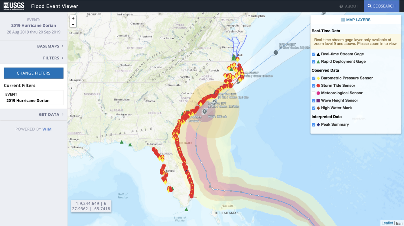
The USGS maintains a nationwide network of permanent water gages to measure and monitor surface water flow, groundwater levels and more. USGS also deploys rapid response water level gages and hurricane storm tide sensors when extreme storms or other hazardous conditions threaten our coast. Data from these sensors are displayed on the USGS Flood Event Viewer. In collaboration with stakeholders, USGS has constructed a national Surge, Wave, and Tide Hydrodynamics (SWaTH) Network that monitors and documents the height, extent, and timing of storm surge. These data are provided to scientists, stakeholders, and the public in real time through the National Water Dashboard.
Media

Sources/Usage: Public Domain. View Media Details
Coastal Geologic Hazards
The nation's coastlines are also vulnerable to more abrupt, interrelated hazards posed by earthquakes, tsunamis, and land-based failures like landslides. USGS studies the processes and effects of earthquakes, landslides, and modern-day and prehistoric tsunamis using a variety of methods. These data are used to generate models, simulations, and probabilities of the likelihood of these hazards with the goal of providing relevant scientific information that can be used to help prevent loss of life, injuries, and property damage.
Other long-term hazardous processes studied by USGS include the seasonal freezing, thawing, and erosion of permafrost coasts that threaten coastal communities and infrastructure in Arctic Alaska.
Media

Sources/Usage: Public Domain. View Media Details
Natural Barriers
While many hazards threaten our coasts, Earth has provided numerous natural structures to protect them such as barrier islands, wetlands, and reefs. For instance, coral reefs act as very effective buffers that break waves and limit flooding in tropical states and U.S. territories. USGS research has quantified the economic benefits of these natural ecosystems, as well as the predicted effects of restoration, which will help inform partners working to protect and conserve coral reefs around the world.
Media

Sources/Usage: Public Domain. View Media Details
Invisible Hazards
Less visible hazards such as toxins, pathogens, saltwater intrusion, and wastewater discharge threaten coastal ecosystems and wildlife as well as the people who live, work, and play along our coasts. These contaminants can enter our coastal waterways through seepage, spills, runoff, or through groundwater discharge. These substances can also become entrained in sediments that can impact ecological health. The USGS monitors water quality, sediments, and living organisms in our coastal regions to track whether contamination has occurred in our waterways to help inform water managers when to treat, close, or otherwise mitigate these hazardous scenarios.
Science

Coastal Climate Impacts
The impacts of climate change and sea-level rise around the Pacific and Arctic Oceans can vary tremendously. Thus far the vast majority of national and international impact assessments and models of coastal climate change have focused on low-relief coastlines that are not near seismically active zones. Furthermore, the degree to which extreme waves and wind will add further stress to coastal...

Dynamic coastlines along the western U.S.
The west coast of the United States is extremely complex and changeable because of tectonic activity, mountain building, and land subsidence. These active environments pose a major challenge for accurately assessing climate change impacts, since models were historically developed for more passive sandy coasts.

Role of Reefs in Coastal Protection
We are combining ocean, engineering, ecologic, social, and economic modeling to provide a high-resolution, rigorous, spatially-explicit valuation of the coastal flood protection benefits provided by coral reefs and the cost effectiveness of reef restoration for enhancing those benefits.

Low-lying areas of tropical Pacific islands
Sea level is rising faster than projected in the western Pacific, so understanding how wave-driven coastal flooding will affect inhabited, low-lying islands—most notably, the familiar ring-shaped atolls—as well as the low-elevation areas of high islands in the Pacific Ocean, is critical for decision-makers in protecting infrastructure or relocating resources and people.

Landscape Response to Disturbance
This project characterizes and measures sediment-related effects of landscape disturbances (such as major storms, drought, or wildfire) and river management. We focus primarily on the U.S. west coast, and our work relates to natural hazards and resource management.
Multimedia

Rincón, Puerto Rico, View 1
Buildings destroyed during Hurricane Maria in Rincón, Puerto Rico. Photograph taken on August 28, 2021, almost four years after the hurricane.

USGS Coastal Change Hazards
The USGS Coastal Change Hazards team works to identify and address the Nation’s coastal change hazards problems. By integrating research, technical capabilities and applications, and stakeholder engagement and communications, the Coastal Change Hazards team develops robust and accessible coastal change assessments, forecasts, and tools that help improve the lives,
The USGS Coastal Change Hazards team works to identify and address the Nation’s coastal change hazards problems. By integrating research, technical capabilities and applications, and stakeholder engagement and communications, the Coastal Change Hazards team develops robust and accessible coastal change assessments, forecasts, and tools that help improve the lives,

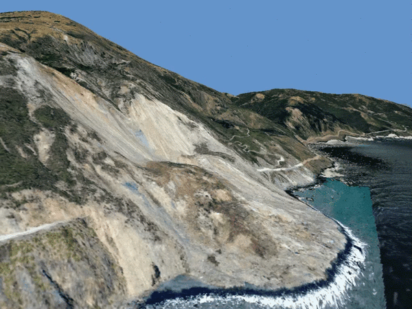
Image of the Week: Mudslide Cuts Through Big Sur Burn Scar
Image of the Week: Mudslide Cuts Through Big Sur Burn ScarA mudslide near the 2020 Dolan Fire's ignition point chopped through a chunk of California's scenic State Highway 1 in late January.
The Dolan Fire began near Big Sur on August 18th, 2020. It scarred nearly 125,000 acres before being fully contained in December.

Portable single-beam echo sounder set-up
Marine engineering technician Pete Dal Ferro sets up a newly acquired, portable, single-beam echo sounder on the San Lorenzo River in Santa Cruz, California. The new device, called CEESCOPE, collects bathymetric (depth) data and also records features of the subsurface.
Marine engineering technician Pete Dal Ferro sets up a newly acquired, portable, single-beam echo sounder on the San Lorenzo River in Santa Cruz, California. The new device, called CEESCOPE, collects bathymetric (depth) data and also records features of the subsurface.

USGS Erosion Simulation Video
This video demonstrates a simulation of how storms can impact sandy coastlines through processes such as erosion. This demonstration is conducted at outreach events by scientists at the St. Petersburg Coastal and Marine Science Center. The activity can also be re-created at home or in the classroom.
This video demonstrates a simulation of how storms can impact sandy coastlines through processes such as erosion. This demonstration is conducted at outreach events by scientists at the St. Petersburg Coastal and Marine Science Center. The activity can also be re-created at home or in the classroom.

How Our Reefs Protect Us: Valuing the Benefits of U.S. Reefs
How Our Reefs Protect Us: Valuing the Benefits of U.S. ReefsThe degradation of coastal habitats, particularly coral reefs, raises risks by increasing the exposure of coastal communities to flooding hazards during storms. The protective services of these natural defenses are not assessed in the same rigorous economic terms as artificial defenses, such as seawalls, and therefore often are not considered in decision-making.

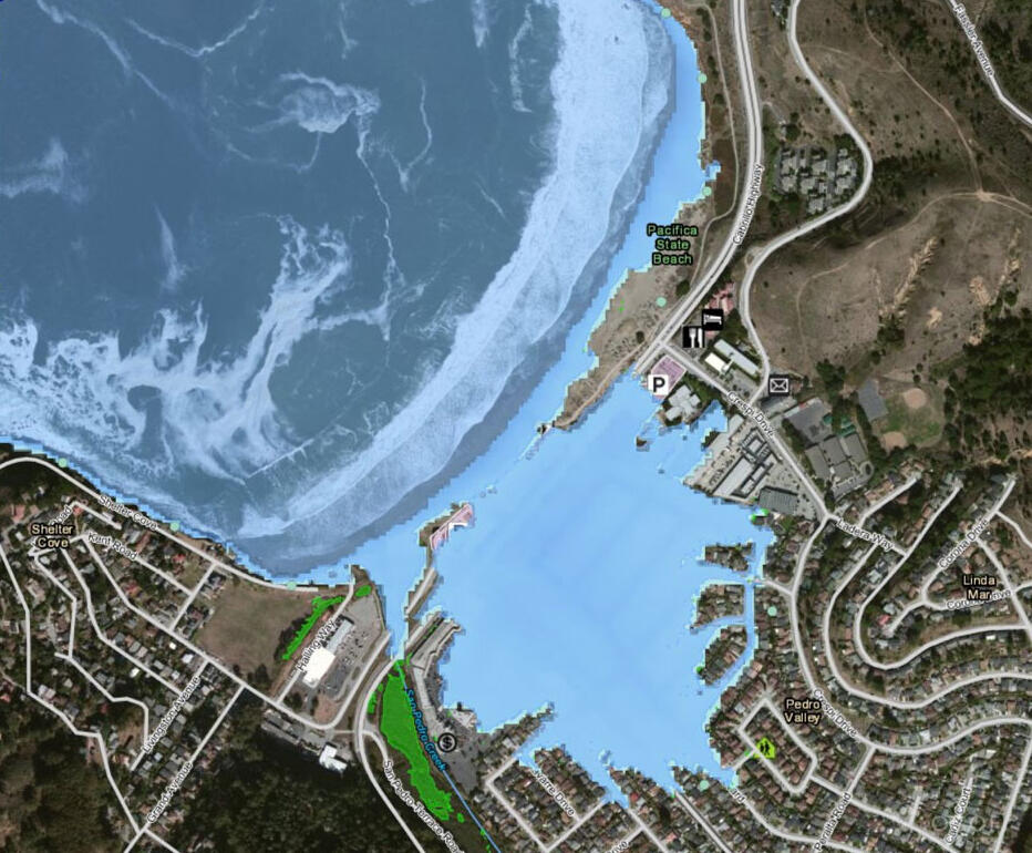
Simulated flooding for 100-year storm event, San Juan
Simulated flooding for 100-year storm event, San JuanMap showing the simulated flooding for a 100-year storm event with (blue) and without (red) coral reefs in San Juan, Puerto Rico. The red area thus represents the area protected by coral reefs.

Whiskey Creek section of Whiskeytown Lake
In the aftermath of the 2018 Carr Fire, northern California, sediment has eroded from burned hillslopes and accumulated in some areas of Whiskeytown Lake. A recent sediment deposit is shown here in the Whiskey Creek section of the lake.
In the aftermath of the 2018 Carr Fire, northern California, sediment has eroded from burned hillslopes and accumulated in some areas of Whiskeytown Lake. A recent sediment deposit is shown here in the Whiskey Creek section of the lake.

Tuolumne watershed landslides
USGS scientists examining landslides in the Tuolumne watershed, California, caused by an extreme rain event in 2018.
USGS scientists examining landslides in the Tuolumne watershed, California, caused by an extreme rain event in 2018.
Filter Total Items: 14
Coastal Climate Impacts
The impacts of climate change and sea-level rise around the Pacific and Arctic Oceans can vary tremendously. Thus far the vast majority of national and international impact assessments and models of coastal climate change have focused on low-relief coastlines that are not near seismically active zones. Furthermore, the degree to which extreme waves and wind will add further stress to coastal...
Dynamic coastlines along the western U.S.
The west coast of the United States is extremely complex and changeable because of tectonic activity, mountain building, and land subsidence. These active environments pose a major challenge for accurately assessing climate change impacts, since models were historically developed for more passive sandy coasts.
Role of Reefs in Coastal Protection
We are combining ocean, engineering, ecologic, social, and economic modeling to provide a high-resolution, rigorous, spatially-explicit valuation of the coastal flood protection benefits provided by coral reefs and the cost effectiveness of reef restoration for enhancing those benefits.
Low-lying areas of tropical Pacific islands
Sea level is rising faster than projected in the western Pacific, so understanding how wave-driven coastal flooding will affect inhabited, low-lying islands—most notably, the familiar ring-shaped atolls—as well as the low-elevation areas of high islands in the Pacific Ocean, is critical for decision-makers in protecting infrastructure or relocating resources and people.
Landscape Response to Disturbance
This project characterizes and measures sediment-related effects of landscape disturbances (such as major storms, drought, or wildfire) and river management. We focus primarily on the U.S. west coast, and our work relates to natural hazards and resource management.

Climate impacts to Arctic coasts
The Arctic region is warming faster than anywhere else in the nation. Understanding the rates and causes of coastal change in Alaska is needed to identify and mitigate hazards that might affect people and animals that call Alaska home.

Climate impacts on Monterey Bay area beaches
For beach towns around Monterey Bay, preserving the beaches by mitigating coastal erosion is vital. Surveys conducted now and regularly in the future will help scientists understand the short- and long-term impacts of climate change, El Niño years, and sea-level rise on a populated and vulnerable coastline.

State of Our Nation's Coast
Discover USGS products, tools, and data with the Coastal Science Navigator! The Coastal Science Navigator serves as a gateway to USGS Coastal Change Hazards resources and assists users in finding products and tools that will meet their specific needs.

Probabilistic Forecasting of Earthquakes, Tsunamis, and Earthquake Effects in the Coastal Zone
The nation's coastlines are vulnerable to the interrelated hazards posed by earthquakes, landslides, and tsunamis. In the marine environment these events often occur in concert, and distant triggers can cause severe local effects, making the issue global in scope. As the population continues to migrate toward the coastlines, the social impacts of these hazards are expected to grow.

Coastal and Marine Geohazards of the U.S. West Coast and Alaska
Coastal and marine geohazards are sudden and extreme events beneath the ocean that threaten coastal populations. These underwater hazards include earthquakes, volcanic eruptions, landslides, and tsunamis. The tectonically active west coast of the Americas is prone to such hazards, as it lies along the boundaries of major tectonic plates that make up the Earth's crust—the North American, Caribbean...

Estuaries and large river deltas in the Pacific Northwest
Essential habitat for wild salmon and other wildlife borders river deltas and estuaries in the Pacific Northwest. These estuaries also support industry, agriculture, and a large human population that’s expected to double by the year 2060, but each could suffer from more severe river floods, higher sea level, and storm surges caused by climate change.

Coastal Change Hazards
Natural processes such as waves, tides, and weather, continually change coastal landscapes. The integrity of coastal homes, businesses, and infrastructure can be threatened by hazards associated with event-driven changes, such as extreme storms and their impacts on beach and dune erosion, or longer-term, cumulative changes associated with coastal and marine processes, such as sea-level rise...
By
Natural Hazards Mission Area, Coastal and Marine Hazards and Resources Program, Pacific Coastal and Marine Science Center, St. Petersburg Coastal and Marine Science Center, Woods Hole Coastal and Marine Science Center, Supplemental Appropriations for Disaster Recovery Activities, Hurricanes, USGS Science in Long Island Sound and its Watershed

Reducing Flood Risks by Restoring Coral Reefs
View audio described version. En español. The increasing risk of flooding along our coasts is driven by climate change, development and habitat loss. Powerful climate-fueled hurricanes such as Irma and Maria in 2017 caused significant damage to coastal communities in Florida and Puerto Rico, not just to infrastructure but to natural barriers such as coral reefs, which help to dissipate wave energy...
Filter Total Items: 36
Rincón, Puerto Rico, View 1
Buildings destroyed during Hurricane Maria in Rincón, Puerto Rico. Photograph taken on August 28, 2021, almost four years after the hurricane.
Buildings destroyed during Hurricane Maria in Rincón, Puerto Rico. Photograph taken on August 28, 2021, almost four years after the hurricane.
USGS Coastal Change Hazards
The USGS Coastal Change Hazards team works to identify and address the Nation’s coastal change hazards problems. By integrating research, technical capabilities and applications, and stakeholder engagement and communications, the Coastal Change Hazards team develops robust and accessible coastal change assessments, forecasts, and tools that help improve the lives,
The USGS Coastal Change Hazards team works to identify and address the Nation’s coastal change hazards problems. By integrating research, technical capabilities and applications, and stakeholder engagement and communications, the Coastal Change Hazards team develops robust and accessible coastal change assessments, forecasts, and tools that help improve the lives,
Image of the Week: Mudslide Cuts Through Big Sur Burn Scar
Image of the Week: Mudslide Cuts Through Big Sur Burn ScarA mudslide near the 2020 Dolan Fire's ignition point chopped through a chunk of California's scenic State Highway 1 in late January.
The Dolan Fire began near Big Sur on August 18th, 2020. It scarred nearly 125,000 acres before being fully contained in December.
Portable single-beam echo sounder set-up
Marine engineering technician Pete Dal Ferro sets up a newly acquired, portable, single-beam echo sounder on the San Lorenzo River in Santa Cruz, California. The new device, called CEESCOPE, collects bathymetric (depth) data and also records features of the subsurface.
Marine engineering technician Pete Dal Ferro sets up a newly acquired, portable, single-beam echo sounder on the San Lorenzo River in Santa Cruz, California. The new device, called CEESCOPE, collects bathymetric (depth) data and also records features of the subsurface.
USGS Erosion Simulation Video
This video demonstrates a simulation of how storms can impact sandy coastlines through processes such as erosion. This demonstration is conducted at outreach events by scientists at the St. Petersburg Coastal and Marine Science Center. The activity can also be re-created at home or in the classroom.
This video demonstrates a simulation of how storms can impact sandy coastlines through processes such as erosion. This demonstration is conducted at outreach events by scientists at the St. Petersburg Coastal and Marine Science Center. The activity can also be re-created at home or in the classroom.
How Our Reefs Protect Us: Valuing the Benefits of U.S. Reefs
How Our Reefs Protect Us: Valuing the Benefits of U.S. ReefsThe degradation of coastal habitats, particularly coral reefs, raises risks by increasing the exposure of coastal communities to flooding hazards during storms. The protective services of these natural defenses are not assessed in the same rigorous economic terms as artificial defenses, such as seawalls, and therefore often are not considered in decision-making.
Simulated flooding for 100-year storm event, San Juan
Simulated flooding for 100-year storm event, San JuanMap showing the simulated flooding for a 100-year storm event with (blue) and without (red) coral reefs in San Juan, Puerto Rico. The red area thus represents the area protected by coral reefs.
Whiskey Creek section of Whiskeytown Lake
In the aftermath of the 2018 Carr Fire, northern California, sediment has eroded from burned hillslopes and accumulated in some areas of Whiskeytown Lake. A recent sediment deposit is shown here in the Whiskey Creek section of the lake.
In the aftermath of the 2018 Carr Fire, northern California, sediment has eroded from burned hillslopes and accumulated in some areas of Whiskeytown Lake. A recent sediment deposit is shown here in the Whiskey Creek section of the lake.
Tuolumne watershed landslides
USGS scientists examining landslides in the Tuolumne watershed, California, caused by an extreme rain event in 2018.
USGS scientists examining landslides in the Tuolumne watershed, California, caused by an extreme rain event in 2018.

USGS Storm-Tide Sensor
USGS storm-tide sensor bolted to a cement jetty on the Atlantic Ocean coast at Fire Island, New York. USGS scientists deployed over 50 sensors along the coast of Maine, New Hampshire, Massachusetts, Rhode Island, Connecticut, New York, New Jersey and Delaware to study a Nor'easter that affected the Northeast in March of 2018.
USGS storm-tide sensor bolted to a cement jetty on the Atlantic Ocean coast at Fire Island, New York. USGS scientists deployed over 50 sensors along the coast of Maine, New Hampshire, Massachusetts, Rhode Island, Connecticut, New York, New Jersey and Delaware to study a Nor'easter that affected the Northeast in March of 2018.
Big Sur Landslide fly around
Big Sur Landslide fly around from May 27, 2017, a preliminary computer animation. The slide created roughly 13 acres of new California land.
Big Sur Landslide fly around from May 27, 2017, a preliminary computer animation. The slide created roughly 13 acres of new California land.

USGS researcher uses GPS-equipped backpack to measure sand elevations
USGS researcher uses GPS-equipped backpack to measure sand elevationsUSGS oceanographer Dan Hoover uses a GPS-equipped backpack to measure sand elevations near the mouth of the San Lorenzo River in Santa Cruz, California, January 12, 2017. Surveys like this make long-term studies of coastal change possible.

Large waves breaking on cliffs in Santa Cruz, California, 02/13/2016
Large waves breaking on cliffs in Santa Cruz, California, 02/13/2016Large waves breaking on cliffs in western Santa Cruz, California, February 13, 2016.
Large waves breaking on cliffs in Santa Cruz, California, 02/13/2016
Large waves breaking on cliffs in Santa Cruz, California, 02/13/2016Large waves breaking on cliffs in western Santa Cruz, California, February 13, 2016.

Santa Cruz coastal erosion
The coastal bluff along East Cliff Drive in Santa Cruz, California are especially vulnerable to rising sea level during big storms. Sometimes even the rip-rap, put in place to protect roadways and homes, cannot protect the bluffs from erosion.
The coastal bluff along East Cliff Drive in Santa Cruz, California are especially vulnerable to rising sea level during big storms. Sometimes even the rip-rap, put in place to protect roadways and homes, cannot protect the bluffs from erosion.

Flooded Coastal Road Santa Cruz County California
Waves flood across a coastal road near Santa Cruz, California.
Waves flood across a coastal road near Santa Cruz, California.

Flood Map, Stinson Beach
Flood maps from Our Coast, Our Future showing Stinson Beach today (slide 1); with a 50-centimeter sea-level rise (slide 2); and when an annual storm strikes in addition to 50-centimeter sea-level rise (slide 3). Green patches are low-lying areas prone to flooding.
Flood maps from Our Coast, Our Future showing Stinson Beach today (slide 1); with a 50-centimeter sea-level rise (slide 2); and when an annual storm strikes in addition to 50-centimeter sea-level rise (slide 3). Green patches are low-lying areas prone to flooding.

Former Secretary of DOI Sally Jewell on field trip to Ocean Beach
Former Secretary of DOI Sally Jewell on field trip to Ocean BeachSecretary Sally Jewell stands on Ocean Beach in San Francisco, where a major part of the road has eroded. USGS research geologist Patrick Barnard (arms crossed) stands at road level, while USGS Office of Communications lead Justin Pressfield takes a photo.

Santa Cruz Main Beach bathymetric survey
USGS scientist Jackson Currie navigates a personal watercraft towards Santa Cruz's Main Beach, to record bathymetric data along a transect.
USGS scientist Jackson Currie navigates a personal watercraft towards Santa Cruz's Main Beach, to record bathymetric data along a transect.

High waves and king tides becoming more frequent in low-lying atolls
High waves and king tides becoming more frequent in low-lying atollsHigh waves coupled with king tides hit the Jable side of Majuro in the Marshall Islands in October 2014, and damaged homes and agriculture—an event that has become more frequent in low-lying atolls.

King tide follows flooding from storm surge
Residents in the northern part of the capital city of Majuro in the Marshall Islands watch as their neighborhood floods with seawater during a king tide. This high tide followed flooding from storm surge earlier that day (March 3, 2014).
Residents in the northern part of the capital city of Majuro in the Marshall Islands watch as their neighborhood floods with seawater during a king tide. This high tide followed flooding from storm surge earlier that day (March 3, 2014).

Overwash event in Marshall Islands
Large swells from the north-northeast with heights up to 5 meters (16 feet) combined with unusually high tides inundated much of the Republic of the Marshall Islands on March 2, 2014.
Large swells from the north-northeast with heights up to 5 meters (16 feet) combined with unusually high tides inundated much of the Republic of the Marshall Islands on March 2, 2014.
Coastal hazards such as hurricanes, sea-level rise, flooding, erosion, and extreme storms can threaten lives and health, property, and valuable habitats along our nation’s coasts. USGS science, products, and tools provide the Nation with robust and accessible scientific research to help partners anticipate, prepare for, adapt to, and mitigate coastal hazards.
While coastal change is natural, hazards arise when these changes threaten lives or put communities and habitats at risk. Some of these hazards can occur abruptly such as earthquakes, landslides, and tsunamis; or within short periods of time such as hurricanes and extreme storms. Others happen gradually over time like sea-level rise, erosion, or saltwater intrusion into groundwater. The USGS is a leader in natural hazards research and addresses coastal hazards by conducting basic and applied research, developing tools to assess risk, and providing data and information to stakeholders and partners to enhance preparedness.
Tools and Technology for Coastal Resilience
The USGS collection of coastal tools provides information on coastal hazards at scales useful for local communities, regional managers, and decision makers. For example, the USGS Coastal Change Hazards Portal allows users to explore the potential for storm-induced coastal erosion, forecasts of extreme water levels, historical shoreline change, and vulnerability to sea-level rise. These data and products are immensely valuable for assisting communities with efforts to bolster coastal resilience and reduce vulnerability to coastal hazards.
Sources/Usage: Public Domain. View Media Details
Media
Sources/Usage: Public Domain. View Media Details
Hurricane Response
Hurricanes are an example of one type of hazard that can cause significant changes to the coast. When a storm is approaching, USGS activates the Coastal Storm Response team, which is comprised of scientists and technicians with multidisciplinary expertise to share information, forecast impacts, and help communities in the storm’s track prepare for and recover from powerful storms. Take a quiz to learn about the breadth of USGS science that goes into helping storm forecasters, emergency responders, communities, resource managers and other decision-makers prepare for, cope with, and recover from storms.
Media
Sources/Usage: Public Domain. View Media Details
Water and Flooding
The USGS maintains a nationwide network of permanent water gages to measure and monitor surface water flow, groundwater levels and more. USGS also deploys rapid response water level gages and hurricane storm tide sensors when extreme storms or other hazardous conditions threaten our coast. Data from these sensors are displayed on the USGS Flood Event Viewer. In collaboration with stakeholders, USGS has constructed a national Surge, Wave, and Tide Hydrodynamics (SWaTH) Network that monitors and documents the height, extent, and timing of storm surge. These data are provided to scientists, stakeholders, and the public in real time through the National Water Dashboard.
Media
Sources/Usage: Public Domain. View Media Details
Coastal Geologic Hazards
The nation's coastlines are also vulnerable to more abrupt, interrelated hazards posed by earthquakes, tsunamis, and land-based failures like landslides. USGS studies the processes and effects of earthquakes, landslides, and modern-day and prehistoric tsunamis using a variety of methods. These data are used to generate models, simulations, and probabilities of the likelihood of these hazards with the goal of providing relevant scientific information that can be used to help prevent loss of life, injuries, and property damage.
Other long-term hazardous processes studied by USGS include the seasonal freezing, thawing, and erosion of permafrost coasts that threaten coastal communities and infrastructure in Arctic Alaska.
Media
Sources/Usage: Public Domain. View Media Details
Natural Barriers
While many hazards threaten our coasts, Earth has provided numerous natural structures to protect them such as barrier islands, wetlands, and reefs. For instance, coral reefs act as very effective buffers that break waves and limit flooding in tropical states and U.S. territories. USGS research has quantified the economic benefits of these natural ecosystems, as well as the predicted effects of restoration, which will help inform partners working to protect and conserve coral reefs around the world.
Media
Sources/Usage: Public Domain. View Media Details
Invisible Hazards
Less visible hazards such as toxins, pathogens, saltwater intrusion, and wastewater discharge threaten coastal ecosystems and wildlife as well as the people who live, work, and play along our coasts. These contaminants can enter our coastal waterways through seepage, spills, runoff, or through groundwater discharge. These substances can also become entrained in sediments that can impact ecological health. The USGS monitors water quality, sediments, and living organisms in our coastal regions to track whether contamination has occurred in our waterways to help inform water managers when to treat, close, or otherwise mitigate these hazardous scenarios.
Science
Coastal Climate Impacts
The impacts of climate change and sea-level rise around the Pacific and Arctic Oceans can vary tremendously. Thus far the vast majority of national and international impact assessments and models of coastal climate change have focused on low-relief coastlines that are not near seismically active zones. Furthermore, the degree to which extreme waves and wind will add further stress to coastal...
Dynamic coastlines along the western U.S.
The west coast of the United States is extremely complex and changeable because of tectonic activity, mountain building, and land subsidence. These active environments pose a major challenge for accurately assessing climate change impacts, since models were historically developed for more passive sandy coasts.
Role of Reefs in Coastal Protection
We are combining ocean, engineering, ecologic, social, and economic modeling to provide a high-resolution, rigorous, spatially-explicit valuation of the coastal flood protection benefits provided by coral reefs and the cost effectiveness of reef restoration for enhancing those benefits.
Low-lying areas of tropical Pacific islands
Sea level is rising faster than projected in the western Pacific, so understanding how wave-driven coastal flooding will affect inhabited, low-lying islands—most notably, the familiar ring-shaped atolls—as well as the low-elevation areas of high islands in the Pacific Ocean, is critical for decision-makers in protecting infrastructure or relocating resources and people.
Landscape Response to Disturbance
This project characterizes and measures sediment-related effects of landscape disturbances (such as major storms, drought, or wildfire) and river management. We focus primarily on the U.S. west coast, and our work relates to natural hazards and resource management.
Multimedia
Rincón, Puerto Rico, View 1
Buildings destroyed during Hurricane Maria in Rincón, Puerto Rico. Photograph taken on August 28, 2021, almost four years after the hurricane.
Buildings destroyed during Hurricane Maria in Rincón, Puerto Rico. Photograph taken on August 28, 2021, almost four years after the hurricane.
USGS Coastal Change Hazards
The USGS Coastal Change Hazards team works to identify and address the Nation’s coastal change hazards problems. By integrating research, technical capabilities and applications, and stakeholder engagement and communications, the Coastal Change Hazards team develops robust and accessible coastal change assessments, forecasts, and tools that help improve the lives,
The USGS Coastal Change Hazards team works to identify and address the Nation’s coastal change hazards problems. By integrating research, technical capabilities and applications, and stakeholder engagement and communications, the Coastal Change Hazards team develops robust and accessible coastal change assessments, forecasts, and tools that help improve the lives,
Image of the Week: Mudslide Cuts Through Big Sur Burn Scar
Image of the Week: Mudslide Cuts Through Big Sur Burn ScarA mudslide near the 2020 Dolan Fire's ignition point chopped through a chunk of California's scenic State Highway 1 in late January.
The Dolan Fire began near Big Sur on August 18th, 2020. It scarred nearly 125,000 acres before being fully contained in December.
Image of the Week: Mudslide Cuts Through Big Sur Burn Scar
Image of the Week: Mudslide Cuts Through Big Sur Burn ScarA mudslide near the 2020 Dolan Fire's ignition point chopped through a chunk of California's scenic State Highway 1 in late January.
The Dolan Fire began near Big Sur on August 18th, 2020. It scarred nearly 125,000 acres before being fully contained in December.
Portable single-beam echo sounder set-up
Marine engineering technician Pete Dal Ferro sets up a newly acquired, portable, single-beam echo sounder on the San Lorenzo River in Santa Cruz, California. The new device, called CEESCOPE, collects bathymetric (depth) data and also records features of the subsurface.
Marine engineering technician Pete Dal Ferro sets up a newly acquired, portable, single-beam echo sounder on the San Lorenzo River in Santa Cruz, California. The new device, called CEESCOPE, collects bathymetric (depth) data and also records features of the subsurface.
USGS Erosion Simulation Video
This video demonstrates a simulation of how storms can impact sandy coastlines through processes such as erosion. This demonstration is conducted at outreach events by scientists at the St. Petersburg Coastal and Marine Science Center. The activity can also be re-created at home or in the classroom.
This video demonstrates a simulation of how storms can impact sandy coastlines through processes such as erosion. This demonstration is conducted at outreach events by scientists at the St. Petersburg Coastal and Marine Science Center. The activity can also be re-created at home or in the classroom.
How Our Reefs Protect Us: Valuing the Benefits of U.S. Reefs
How Our Reefs Protect Us: Valuing the Benefits of U.S. ReefsThe degradation of coastal habitats, particularly coral reefs, raises risks by increasing the exposure of coastal communities to flooding hazards during storms. The protective services of these natural defenses are not assessed in the same rigorous economic terms as artificial defenses, such as seawalls, and therefore often are not considered in decision-making.
How Our Reefs Protect Us: Valuing the Benefits of U.S. Reefs
How Our Reefs Protect Us: Valuing the Benefits of U.S. ReefsThe degradation of coastal habitats, particularly coral reefs, raises risks by increasing the exposure of coastal communities to flooding hazards during storms. The protective services of these natural defenses are not assessed in the same rigorous economic terms as artificial defenses, such as seawalls, and therefore often are not considered in decision-making.
Simulated flooding for 100-year storm event, San Juan
Simulated flooding for 100-year storm event, San JuanMap showing the simulated flooding for a 100-year storm event with (blue) and without (red) coral reefs in San Juan, Puerto Rico. The red area thus represents the area protected by coral reefs.
Simulated flooding for 100-year storm event, San Juan
Simulated flooding for 100-year storm event, San JuanMap showing the simulated flooding for a 100-year storm event with (blue) and without (red) coral reefs in San Juan, Puerto Rico. The red area thus represents the area protected by coral reefs.
Whiskey Creek section of Whiskeytown Lake
In the aftermath of the 2018 Carr Fire, northern California, sediment has eroded from burned hillslopes and accumulated in some areas of Whiskeytown Lake. A recent sediment deposit is shown here in the Whiskey Creek section of the lake.
In the aftermath of the 2018 Carr Fire, northern California, sediment has eroded from burned hillslopes and accumulated in some areas of Whiskeytown Lake. A recent sediment deposit is shown here in the Whiskey Creek section of the lake.
Tuolumne watershed landslides
USGS scientists examining landslides in the Tuolumne watershed, California, caused by an extreme rain event in 2018.
USGS scientists examining landslides in the Tuolumne watershed, California, caused by an extreme rain event in 2018.
Filter Total Items: 14
Coastal Climate Impacts
The impacts of climate change and sea-level rise around the Pacific and Arctic Oceans can vary tremendously. Thus far the vast majority of national and international impact assessments and models of coastal climate change have focused on low-relief coastlines that are not near seismically active zones. Furthermore, the degree to which extreme waves and wind will add further stress to coastal...
Dynamic coastlines along the western U.S.
The west coast of the United States is extremely complex and changeable because of tectonic activity, mountain building, and land subsidence. These active environments pose a major challenge for accurately assessing climate change impacts, since models were historically developed for more passive sandy coasts.
Role of Reefs in Coastal Protection
We are combining ocean, engineering, ecologic, social, and economic modeling to provide a high-resolution, rigorous, spatially-explicit valuation of the coastal flood protection benefits provided by coral reefs and the cost effectiveness of reef restoration for enhancing those benefits.
Low-lying areas of tropical Pacific islands
Sea level is rising faster than projected in the western Pacific, so understanding how wave-driven coastal flooding will affect inhabited, low-lying islands—most notably, the familiar ring-shaped atolls—as well as the low-elevation areas of high islands in the Pacific Ocean, is critical for decision-makers in protecting infrastructure or relocating resources and people.
Landscape Response to Disturbance
This project characterizes and measures sediment-related effects of landscape disturbances (such as major storms, drought, or wildfire) and river management. We focus primarily on the U.S. west coast, and our work relates to natural hazards and resource management.
Climate impacts to Arctic coasts
The Arctic region is warming faster than anywhere else in the nation. Understanding the rates and causes of coastal change in Alaska is needed to identify and mitigate hazards that might affect people and animals that call Alaska home.
Climate impacts on Monterey Bay area beaches
For beach towns around Monterey Bay, preserving the beaches by mitigating coastal erosion is vital. Surveys conducted now and regularly in the future will help scientists understand the short- and long-term impacts of climate change, El Niño years, and sea-level rise on a populated and vulnerable coastline.
State of Our Nation's Coast
Discover USGS products, tools, and data with the Coastal Science Navigator! The Coastal Science Navigator serves as a gateway to USGS Coastal Change Hazards resources and assists users in finding products and tools that will meet their specific needs.
Probabilistic Forecasting of Earthquakes, Tsunamis, and Earthquake Effects in the Coastal Zone
The nation's coastlines are vulnerable to the interrelated hazards posed by earthquakes, landslides, and tsunamis. In the marine environment these events often occur in concert, and distant triggers can cause severe local effects, making the issue global in scope. As the population continues to migrate toward the coastlines, the social impacts of these hazards are expected to grow.
Coastal and Marine Geohazards of the U.S. West Coast and Alaska
Coastal and marine geohazards are sudden and extreme events beneath the ocean that threaten coastal populations. These underwater hazards include earthquakes, volcanic eruptions, landslides, and tsunamis. The tectonically active west coast of the Americas is prone to such hazards, as it lies along the boundaries of major tectonic plates that make up the Earth's crust—the North American, Caribbean...
Estuaries and large river deltas in the Pacific Northwest
Essential habitat for wild salmon and other wildlife borders river deltas and estuaries in the Pacific Northwest. These estuaries also support industry, agriculture, and a large human population that’s expected to double by the year 2060, but each could suffer from more severe river floods, higher sea level, and storm surges caused by climate change.
Coastal Change Hazards
Natural processes such as waves, tides, and weather, continually change coastal landscapes. The integrity of coastal homes, businesses, and infrastructure can be threatened by hazards associated with event-driven changes, such as extreme storms and their impacts on beach and dune erosion, or longer-term, cumulative changes associated with coastal and marine processes, such as sea-level rise...
By
Natural Hazards Mission Area, Coastal and Marine Hazards and Resources Program, Pacific Coastal and Marine Science Center, St. Petersburg Coastal and Marine Science Center, Woods Hole Coastal and Marine Science Center, Supplemental Appropriations for Disaster Recovery Activities, Hurricanes, USGS Science in Long Island Sound and its Watershed
Reducing Flood Risks by Restoring Coral Reefs
View audio described version. En español. The increasing risk of flooding along our coasts is driven by climate change, development and habitat loss. Powerful climate-fueled hurricanes such as Irma and Maria in 2017 caused significant damage to coastal communities in Florida and Puerto Rico, not just to infrastructure but to natural barriers such as coral reefs, which help to dissipate wave energy...
Filter Total Items: 36
Rincón, Puerto Rico, View 1
Buildings destroyed during Hurricane Maria in Rincón, Puerto Rico. Photograph taken on August 28, 2021, almost four years after the hurricane.
Buildings destroyed during Hurricane Maria in Rincón, Puerto Rico. Photograph taken on August 28, 2021, almost four years after the hurricane.
USGS Coastal Change Hazards
The USGS Coastal Change Hazards team works to identify and address the Nation’s coastal change hazards problems. By integrating research, technical capabilities and applications, and stakeholder engagement and communications, the Coastal Change Hazards team develops robust and accessible coastal change assessments, forecasts, and tools that help improve the lives,
The USGS Coastal Change Hazards team works to identify and address the Nation’s coastal change hazards problems. By integrating research, technical capabilities and applications, and stakeholder engagement and communications, the Coastal Change Hazards team develops robust and accessible coastal change assessments, forecasts, and tools that help improve the lives,
Image of the Week: Mudslide Cuts Through Big Sur Burn Scar
Image of the Week: Mudslide Cuts Through Big Sur Burn ScarA mudslide near the 2020 Dolan Fire's ignition point chopped through a chunk of California's scenic State Highway 1 in late January.
The Dolan Fire began near Big Sur on August 18th, 2020. It scarred nearly 125,000 acres before being fully contained in December.
Image of the Week: Mudslide Cuts Through Big Sur Burn Scar
Image of the Week: Mudslide Cuts Through Big Sur Burn ScarA mudslide near the 2020 Dolan Fire's ignition point chopped through a chunk of California's scenic State Highway 1 in late January.
The Dolan Fire began near Big Sur on August 18th, 2020. It scarred nearly 125,000 acres before being fully contained in December.
Portable single-beam echo sounder set-up
Marine engineering technician Pete Dal Ferro sets up a newly acquired, portable, single-beam echo sounder on the San Lorenzo River in Santa Cruz, California. The new device, called CEESCOPE, collects bathymetric (depth) data and also records features of the subsurface.
Marine engineering technician Pete Dal Ferro sets up a newly acquired, portable, single-beam echo sounder on the San Lorenzo River in Santa Cruz, California. The new device, called CEESCOPE, collects bathymetric (depth) data and also records features of the subsurface.
USGS Erosion Simulation Video
This video demonstrates a simulation of how storms can impact sandy coastlines through processes such as erosion. This demonstration is conducted at outreach events by scientists at the St. Petersburg Coastal and Marine Science Center. The activity can also be re-created at home or in the classroom.
This video demonstrates a simulation of how storms can impact sandy coastlines through processes such as erosion. This demonstration is conducted at outreach events by scientists at the St. Petersburg Coastal and Marine Science Center. The activity can also be re-created at home or in the classroom.
How Our Reefs Protect Us: Valuing the Benefits of U.S. Reefs
How Our Reefs Protect Us: Valuing the Benefits of U.S. ReefsThe degradation of coastal habitats, particularly coral reefs, raises risks by increasing the exposure of coastal communities to flooding hazards during storms. The protective services of these natural defenses are not assessed in the same rigorous economic terms as artificial defenses, such as seawalls, and therefore often are not considered in decision-making.
How Our Reefs Protect Us: Valuing the Benefits of U.S. Reefs
How Our Reefs Protect Us: Valuing the Benefits of U.S. ReefsThe degradation of coastal habitats, particularly coral reefs, raises risks by increasing the exposure of coastal communities to flooding hazards during storms. The protective services of these natural defenses are not assessed in the same rigorous economic terms as artificial defenses, such as seawalls, and therefore often are not considered in decision-making.
Simulated flooding for 100-year storm event, San Juan
Simulated flooding for 100-year storm event, San JuanMap showing the simulated flooding for a 100-year storm event with (blue) and without (red) coral reefs in San Juan, Puerto Rico. The red area thus represents the area protected by coral reefs.
Simulated flooding for 100-year storm event, San Juan
Simulated flooding for 100-year storm event, San JuanMap showing the simulated flooding for a 100-year storm event with (blue) and without (red) coral reefs in San Juan, Puerto Rico. The red area thus represents the area protected by coral reefs.
Whiskey Creek section of Whiskeytown Lake
In the aftermath of the 2018 Carr Fire, northern California, sediment has eroded from burned hillslopes and accumulated in some areas of Whiskeytown Lake. A recent sediment deposit is shown here in the Whiskey Creek section of the lake.
In the aftermath of the 2018 Carr Fire, northern California, sediment has eroded from burned hillslopes and accumulated in some areas of Whiskeytown Lake. A recent sediment deposit is shown here in the Whiskey Creek section of the lake.
Tuolumne watershed landslides
USGS scientists examining landslides in the Tuolumne watershed, California, caused by an extreme rain event in 2018.
USGS scientists examining landslides in the Tuolumne watershed, California, caused by an extreme rain event in 2018.
USGS Storm-Tide Sensor
USGS storm-tide sensor bolted to a cement jetty on the Atlantic Ocean coast at Fire Island, New York. USGS scientists deployed over 50 sensors along the coast of Maine, New Hampshire, Massachusetts, Rhode Island, Connecticut, New York, New Jersey and Delaware to study a Nor'easter that affected the Northeast in March of 2018.
USGS storm-tide sensor bolted to a cement jetty on the Atlantic Ocean coast at Fire Island, New York. USGS scientists deployed over 50 sensors along the coast of Maine, New Hampshire, Massachusetts, Rhode Island, Connecticut, New York, New Jersey and Delaware to study a Nor'easter that affected the Northeast in March of 2018.
Big Sur Landslide fly around
Big Sur Landslide fly around from May 27, 2017, a preliminary computer animation. The slide created roughly 13 acres of new California land.
Big Sur Landslide fly around from May 27, 2017, a preliminary computer animation. The slide created roughly 13 acres of new California land.
USGS researcher uses GPS-equipped backpack to measure sand elevations
USGS researcher uses GPS-equipped backpack to measure sand elevationsUSGS oceanographer Dan Hoover uses a GPS-equipped backpack to measure sand elevations near the mouth of the San Lorenzo River in Santa Cruz, California, January 12, 2017. Surveys like this make long-term studies of coastal change possible.
Large waves breaking on cliffs in Santa Cruz, California, 02/13/2016
Large waves breaking on cliffs in Santa Cruz, California, 02/13/2016Large waves breaking on cliffs in western Santa Cruz, California, February 13, 2016.
Large waves breaking on cliffs in Santa Cruz, California, 02/13/2016
Large waves breaking on cliffs in Santa Cruz, California, 02/13/2016Large waves breaking on cliffs in western Santa Cruz, California, February 13, 2016.
Santa Cruz coastal erosion
The coastal bluff along East Cliff Drive in Santa Cruz, California are especially vulnerable to rising sea level during big storms. Sometimes even the rip-rap, put in place to protect roadways and homes, cannot protect the bluffs from erosion.
The coastal bluff along East Cliff Drive in Santa Cruz, California are especially vulnerable to rising sea level during big storms. Sometimes even the rip-rap, put in place to protect roadways and homes, cannot protect the bluffs from erosion.
Flooded Coastal Road Santa Cruz County California
Waves flood across a coastal road near Santa Cruz, California.
Waves flood across a coastal road near Santa Cruz, California.
Flood Map, Stinson Beach
Flood maps from Our Coast, Our Future showing Stinson Beach today (slide 1); with a 50-centimeter sea-level rise (slide 2); and when an annual storm strikes in addition to 50-centimeter sea-level rise (slide 3). Green patches are low-lying areas prone to flooding.
Flood maps from Our Coast, Our Future showing Stinson Beach today (slide 1); with a 50-centimeter sea-level rise (slide 2); and when an annual storm strikes in addition to 50-centimeter sea-level rise (slide 3). Green patches are low-lying areas prone to flooding.
Former Secretary of DOI Sally Jewell on field trip to Ocean Beach
Former Secretary of DOI Sally Jewell on field trip to Ocean BeachSecretary Sally Jewell stands on Ocean Beach in San Francisco, where a major part of the road has eroded. USGS research geologist Patrick Barnard (arms crossed) stands at road level, while USGS Office of Communications lead Justin Pressfield takes a photo.
Santa Cruz Main Beach bathymetric survey
USGS scientist Jackson Currie navigates a personal watercraft towards Santa Cruz's Main Beach, to record bathymetric data along a transect.
USGS scientist Jackson Currie navigates a personal watercraft towards Santa Cruz's Main Beach, to record bathymetric data along a transect.
High waves and king tides becoming more frequent in low-lying atolls
High waves and king tides becoming more frequent in low-lying atollsHigh waves coupled with king tides hit the Jable side of Majuro in the Marshall Islands in October 2014, and damaged homes and agriculture—an event that has become more frequent in low-lying atolls.
King tide follows flooding from storm surge
Residents in the northern part of the capital city of Majuro in the Marshall Islands watch as their neighborhood floods with seawater during a king tide. This high tide followed flooding from storm surge earlier that day (March 3, 2014).
Residents in the northern part of the capital city of Majuro in the Marshall Islands watch as their neighborhood floods with seawater during a king tide. This high tide followed flooding from storm surge earlier that day (March 3, 2014).
Overwash event in Marshall Islands
Large swells from the north-northeast with heights up to 5 meters (16 feet) combined with unusually high tides inundated much of the Republic of the Marshall Islands on March 2, 2014.
Large swells from the north-northeast with heights up to 5 meters (16 feet) combined with unusually high tides inundated much of the Republic of the Marshall Islands on March 2, 2014.