
USGS Chesapeake Bay Science Accomplishments for 2025
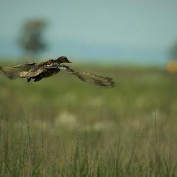
The Chesapeake Bay watershed is home to 18 million people and some of America’s most treasured natural resources – lands, waters, and wildlife that support a strong economy and cherished outdoor traditions, such as hunting and fishing. From local organizations to federal agencies, partners throughout the watershed are working to protect these resources. These partners rely on our unbiased, gold standard science to make informed decisions and streamline conservation actions. By monitoring rivers, measuring streamflow, and assessing populations of prized fish and waterfowl, we provide the data and insights managers need to protect the resources people love.
Selected Accomplishments from 2025
Central to our mission is communicating decision-ready science to help partners better manage lands, water, and wildlife in the Chesapeake Bay watershed. Below are six science topics from 2025 that were used to inform management decisions and advance Department of the Interior priorities. Click the hyperlinks below to explore how our science supports these efforts.
Looking ahead, we will continue advancing these and other priority topics to meet the evolving needs of partners working throughout the Chesapeake Bay.

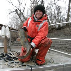
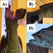
We are studying the impacts of invasive catfish
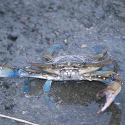
The recent expansion of invasive blue and flathead catfish in the Chesapeake Bay and its major rivers threatens the region’s economically important fisheries and treasured natural resources. We are working in partnership with states, academic institutions, and other federal agencies to understand the extent and size of catfish populations, their impact on valuable native species such as blue crabs and striped bass, and their risks to public health. This science provides fishery managers with the critical information they need to evaluate the cost, feasibility, and effectiveness of strategies to control these invasive species.

We released high-resolution land and water mapping data to inform local decisions
Our detailed data show how lands are used, how those uses are changing over time, and where waterways, including the smallest streams, are located. State and local partners rely on these foundational data to target conservation efforts and make local land-use planning decisions. With detailed maps of streams and agricultural, urban, and forested lands, managers can make informed decisions that best serve their local communities.

We are delivering science that supports clean water and farm biosecurity
Farmers in the Chesapeake Bay watershed provide food security, support the economy, and are important conservation partners. Many farmers are using conservation practices to provide clean water for their families, communities, and livestock. By monitoring the amount and quality of water in local streams, we help farmers and resource managers plan effective conservation practices. In addition, we are studying factors affecting the transmission of avian influenza to protect domestic poultry populations and safeguard the economic vitality of Chesapeake Bay farms.

We are providing key insights to help managers protect priority fish species
Native freshwater fish like brook trout are culturally significant and vital to the region’s economy outdoor traditions. Responding to requests from fishery managers, we are studying factors affecting the health of freshwater fish. This past year, we sampled rivers for a chemical compound found in rubber tires that is known to harm or kill some native fish species. These insights provide fishery managers with critical information to protect priority fish species.

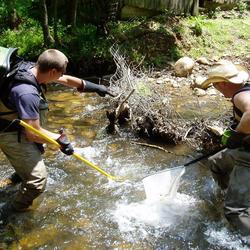
We are monitoring streamflow and water quality in rivers throughout the watershed
We measure streamflow data from over 500 Chesapeake Bay river stations, providing critical data that help emergency managers protect communities and respond to floods and droughts. At over 100 stations, we are working with partners to monitor nutrient and sediment loads, data that help managers meet clean-water goals. By monitoring the health of rivers, we are delivering watershed-wide insights that guide effective conservation activities.

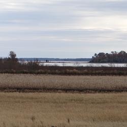
We are using field measurements and geospatial tools to guide marsh restoration needs
Salt marshes provide important benefits such as protecting coastal communities from floods and providing hunting and fishing grounds. Throughout the watershed, managers are working to safeguard these vulnerable systems. We support these efforts through efforts such as estimating marsh lifespans and identifying future restoration needs. Our data help managers evaluate marsh conditions and prioritize management actions.

Learn More About USGS Chesapeake Bay Studies
Chesapeake Bay Home Page
Science Strategy Video
Sign up for Newsletter
Avian Influenza Spread, Prevalence and Persistence
Prioritizing marsh restoration needs throughout Chesapeake Bay
EESC Makes an Impact: Enhancing Recreational & Commercial Fishing

Key considerations to accurately predict tidal marsh longevity

Key Values of a Century of EESC Science
Invasive flathead catfish now top predators in Susquehanna River in Pennsylvania
A regional assessment of fish health in the Chesapeake Bay watershed
EESC Makes an Impact: Restoring the Chesapeake Bay Watershed
Applying Multiple Tools to Inform Management of Per- and Polyfluoroalkyl Substances (PFAS) in the Potomac River Watershed

Artificial Intelligence in the USGS Ecosystems Mission Area

Informing Freshwater Management Strategies in the Chesapeake Bay Watershed by Using Observational Data and Expert Knowledge to Identify Influential Stressors

Pennsylvania and the Chesapeake Bay Watershed
The Chesapeake Bay watershed is home to 18 million people and some of America’s most treasured natural resources – lands, waters, and wildlife that support a strong economy and cherished outdoor traditions, such as hunting and fishing. From local organizations to federal agencies, partners throughout the watershed are working to protect these resources. These partners rely on our unbiased, gold standard science to make informed decisions and streamline conservation actions. By monitoring rivers, measuring streamflow, and assessing populations of prized fish and waterfowl, we provide the data and insights managers need to protect the resources people love.
Selected Accomplishments from 2025
Central to our mission is communicating decision-ready science to help partners better manage lands, water, and wildlife in the Chesapeake Bay watershed. Below are six science topics from 2025 that were used to inform management decisions and advance Department of the Interior priorities. Click the hyperlinks below to explore how our science supports these efforts.
Looking ahead, we will continue advancing these and other priority topics to meet the evolving needs of partners working throughout the Chesapeake Bay.
We are studying the impacts of invasive catfish
The recent expansion of invasive blue and flathead catfish in the Chesapeake Bay and its major rivers threatens the region’s economically important fisheries and treasured natural resources. We are working in partnership with states, academic institutions, and other federal agencies to understand the extent and size of catfish populations, their impact on valuable native species such as blue crabs and striped bass, and their risks to public health. This science provides fishery managers with the critical information they need to evaluate the cost, feasibility, and effectiveness of strategies to control these invasive species.
We released high-resolution land and water mapping data to inform local decisions
Our detailed data show how lands are used, how those uses are changing over time, and where waterways, including the smallest streams, are located. State and local partners rely on these foundational data to target conservation efforts and make local land-use planning decisions. With detailed maps of streams and agricultural, urban, and forested lands, managers can make informed decisions that best serve their local communities.
We are delivering science that supports clean water and farm biosecurity
Farmers in the Chesapeake Bay watershed provide food security, support the economy, and are important conservation partners. Many farmers are using conservation practices to provide clean water for their families, communities, and livestock. By monitoring the amount and quality of water in local streams, we help farmers and resource managers plan effective conservation practices. In addition, we are studying factors affecting the transmission of avian influenza to protect domestic poultry populations and safeguard the economic vitality of Chesapeake Bay farms.
We are providing key insights to help managers protect priority fish species
Native freshwater fish like brook trout are culturally significant and vital to the region’s economy outdoor traditions. Responding to requests from fishery managers, we are studying factors affecting the health of freshwater fish. This past year, we sampled rivers for a chemical compound found in rubber tires that is known to harm or kill some native fish species. These insights provide fishery managers with critical information to protect priority fish species.
We are monitoring streamflow and water quality in rivers throughout the watershed
We measure streamflow data from over 500 Chesapeake Bay river stations, providing critical data that help emergency managers protect communities and respond to floods and droughts. At over 100 stations, we are working with partners to monitor nutrient and sediment loads, data that help managers meet clean-water goals. By monitoring the health of rivers, we are delivering watershed-wide insights that guide effective conservation activities.
We are using field measurements and geospatial tools to guide marsh restoration needs
Salt marshes provide important benefits such as protecting coastal communities from floods and providing hunting and fishing grounds. Throughout the watershed, managers are working to safeguard these vulnerable systems. We support these efforts through efforts such as estimating marsh lifespans and identifying future restoration needs. Our data help managers evaluate marsh conditions and prioritize management actions.
Learn More About USGS Chesapeake Bay Studies
Chesapeake Bay Home Page
Science Strategy Video
Sign up for Newsletter
Avian Influenza Spread, Prevalence and Persistence
Prioritizing marsh restoration needs throughout Chesapeake Bay
EESC Makes an Impact: Enhancing Recreational & Commercial Fishing
Key considerations to accurately predict tidal marsh longevity
Key Values of a Century of EESC Science
Invasive flathead catfish now top predators in Susquehanna River in Pennsylvania
A regional assessment of fish health in the Chesapeake Bay watershed
EESC Makes an Impact: Restoring the Chesapeake Bay Watershed
Applying Multiple Tools to Inform Management of Per- and Polyfluoroalkyl Substances (PFAS) in the Potomac River Watershed
Artificial Intelligence in the USGS Ecosystems Mission Area
Informing Freshwater Management Strategies in the Chesapeake Bay Watershed by Using Observational Data and Expert Knowledge to Identify Influential Stressors