
Landslide Hazards Seminar
Subglacial discharge drives seasonal motion of the Barry Arm Landslide, Prince William Sound, Alaska
May 27, 2026
Multi-site evaluation of a postfire debris-flow runout forecast method
January 28, 2026
Investigating the potential for volcanic island flank collapse and tsunami generation within the Pacific and Indian Oceans
March 18, 2026
The USGS Landslide Hazards Seminar is a speaker series that brings together landslide researchers, academics, students, applied scientists, and others to share their work in a long format. Topics range from deep dives into numerical models to broad overviews of landslide hazards of a state. The 50-minute presentations are presented live on regular Wednesdays at 2:00 PM Mountain Time.
July 8, 2026 - Mirna Kassem, University of California at Berkeley & Stanford University
Watershed-Scale Coupled Hydrological and Hillslope Stability Modeling of Rainfall-Induced Landslides
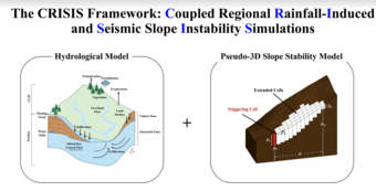
Landslides remain a major global hazard, with thousands of events each year posing significant impacts to human life, infrastructure, and ecosystems. While advanced constitutive models enable detailed slope-stability analyses at the single-hillslope scale, a critical gap persists in assessing landslide hazards at the community scale. Existing regional-scale models often struggle to balance physical rigor, predictive accuracy, and computational efficiency. They rely either on empirical approaches with limited physical basis or on mechanistic formulations that rely on major simplifying assumptions.
This study presents CRISIS (Coupled Regional Rainfall-Induced and Seismic Slope Instability Simulations), a physics-based regional landslide prediction framework. It couples a pseudo-3D slope-stability formulation with a transient three-dimensional groundwater flow model. CRISIS operates in back-analysis and forward-prediction modes, integrating multi-scale topographic, geotechnical, hydraulic, and hydrological data.
Back-analysis of both failed and stable slopes from prior events generates high-resolution spatial estimates of shear strength. These estimates are iteratively refined and used for forward prediction of landslide location, size, depth, and timing under future triggering events. Results reveal a strong geospatial connection between hillslope location and dominant failure mechanisms, emphasizing that landslide initiation is inherently geospatial and governed by coupled surface–subsurface processes.
Application of the framework to Hurricane Maria in Puerto Rico, where over 70,000 landslides were triggered, demonstrates close agreement between predicted and observed landslide locations, sizes, and timing. The broader vision of this work is to advance regional characterization, assessment, and mitigation of cascading hazards through data-model integration.
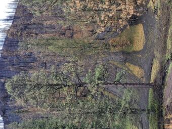
June 17, 2026 - Jessica Ball and Alicia Hotovec-Ellis, USGS
Why the mud flows: Non-eruptive debris flows at Mount Shasta
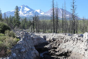
A currently quiescent stratovolcano, Mount Shasta, California, still poses a significant hazard to nearby communities thanks to impactful non-eruptive debris flows that can occur throughout the year. In this work, we have built a more complete record of debris flow occurrence using monitoring campaigns and research into historical newspaper records; analyze debris flow frequency and triggering in the context of regional weather and climate patterns; and forecast the future of debris flow hazards at Mount Shasta. This topic is timely because of its relevance to the ongoing efforts to create up-to-date, usable, and relevant hazards assessments at United States Volcanoes, as well as a need expressed by local land managers for debris flow data. Ultimately, this work will not only enhance our understanding of debris flow occurrence at Mount Shasta, but will also aid stakeholders in land planning, hazard mitigation, and preparedness.
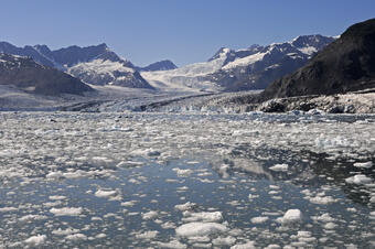
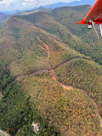
May 27, 2026 - Helen Dow, USGS
Subglacial discharge drives seasonal motion of the Barry Arm Landslide, Prince William Sound, Alaska
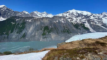
We investigated meteorological controls on seasonal deep-seated motion of the Barry Arm landslide, a ~500 Mm³ slope instability with tsunamigenic potential in Prince William Sound, Alaska. Using ground-based synthetic aperture radar, we identified periods of deep-seated displacement, and combined airborne ice-penetrating radar with a glacier melt model driven by local meteorological data to evaluate the role of Cascade Glacier, which covers much of the area contributing groundwater to the landslide. We show that an over-deepened section of Cascade Glacier adjacent to the most active part of the landslide likely acts as a transient reservoir that routes meltwater to the landslide and that deep-seated landslide motion initiated only when modeled glacier discharge exceeded a distinct threshold.
May 20, 2026 - Dr. Danielle Lindsay, Earth Sciences New Zealand
Earthquake Triggering of Slow-Moving Landslides in Northern California: Insights from 14-day L-band InSAR Time Series Analysis

We quantify slow-moving landslide kinematics across northern California using a 14-day L-band ALOS-2 ScanSAR InSAR time series. After systematically extracting and cleaning the displacement time series, we analyze deformation of 437 landslides across a ∼300 x 400 km area and group time series by relative velocity changes to identify anomalously fast motions. We test associations with external drivers (PGA, precipitation) and landslide attributes (slope, aspect ratio, area). Shaking from the 2022 event shows the strongest association with faster sliding rates. For slides that experienced higher PGA and increased velocities, a piecewise model yields recovery to within ~10% of pre-event rates in ~1.3 years. Using two earthquakes of similar magnitude and location, we demonstrate that rupture dynamics shape the spatial distribution of triggering and supply rare regional constraints on onset and recovery.
May 13, 2026 - Andrew Graber, USGS
Updating methods for postfire debris-flow hazard assessment
For more than a decade, the U.S. Geological Survey (USGS) has provided stakeholders and land managers with postfire debris-flow hazard information to assist them in considering important questions about postfire debris flows, such as “Where will they happen?”, “When will they happen?”, or “How big will they be?” Alongside assessing postfire debris-flow hazards for hundreds of burned areas to date, USGS and partners have identified additional aspects of these hazards that are not well addressed by existing predictive frameworks, such as developing rainfall thresholds for partially recovered conditions, or considering how susceptibility to postfire debris flows might be modified by regional differences in topography or rainfall climatology. This talk will discuss recent work to address these challenges by 1) developing a new method to track the evolution of debris-flow likelihood and rainfall thresholds with time and recovery after fire, and 2) calibrating new regional models to improve prediction of debris-flow likelihood and rainfall thresholds across the western United States.
April 29, 2026 - Dr. Wei-an Chao, National Yang Ming Chiao Tung University
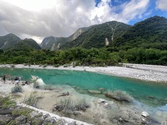
Seismic Monitoring of the Geohazard Chain Following the Matai'an Landslide and Subsequent Landslide Dam Breach
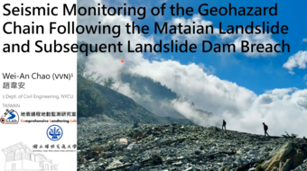
The 2025 Matai’an landslide in eastern Taiwan represents the largest landslide event ever recorded in the region and initiated a cascading hazard sequence involving landslide-dam formation and repeated dam-breach floods. In this talk, I will demonstrate how seismic observations and remote sensing can be integrated to track landslide processes from pre-failure deformation to post-failure hazard evolution. I will also present a seismic-based monitoring framework capable of detecting landslides in near real time, estimating their size, and identifying landslide-dam formation, providing a practical approach for early warning of downstream flood hazards.
April 15, 2026 - Brian Yanites, Indiana University, Bloomington
Cascading River Hazards from Seismic and Tropical Cyclone Triggered Landslides in Taiwan
This talk focuses on cascading river hazards in Taiwan generated by landslides triggered by earthquakes and tropical cyclones. Drawing on case studies from Typhoon Morakot and the 2024 Hualien earthquake, I explore how sediment pulses move through river systems, reshaping channels and sustaining hazard long after the initial event. Together, these examples show how extreme events can produce lasting and evolving impacts in steep landscapes.
March 18, 2026 - Dan O'Hara, USGS
Investigating the potential for volcanic island flank collapse and tsunami generation within the Pacific and Indian Oceans
Volcanic edifice flank collapses are low-frequency, high-magnitude events that can rapidly mobilize tens of km3 of material and transport it large distances (>10 km) from the edifice. In ocean basins, these failures induce secondary hazards through the generation of tsunamis that can impact both neighboring and distal coastlines. These high-risk, far-reaching events have historically generated significant damage and loss of life, such as the 1792 collapse of the Mayuyama dome (Japan) that led to ~15,000 fatalities, and recently the 2018 collapse of Anak Krakatau (Indonesia) that resulted in ~440 deaths. Globally, there are 400–800 oceanic and coastal volcanic edifices with the potential for future collapses and associated tsunamis. Although previous studies have evaluated edifice collapse potential at both single volcanoes and over entire arcs, a global assessment of the edifices that are most capable of producing a tsunami-generating collapse is incomplete, in part because of remote locations and lack of detailed investigations.
Building on previous studies, we develop a multi-component weighting procedure to rank the potential for edifice flank collapse and tsunami generation using three criteria: 1) edifice morphology; 2) satellite-derived estimations on the extent of hydrothermal alteration; and 3) 3D slope-stability analysis of potential collapses. We test this approach on oceanic and coastal volcanic edifices from the Marianas, Aleutians, Indonesia, and Philippines. After describing the results and relative ranking of edifices with the highest potential for collapse, we discuss implications for future tsunami hazard assessment.
March 11, 2026 - PJ Zrelak, University of Oregon and University of Edinburgh
Decoding Granular States: Using granular mechanics to link observations to internal dynamics of geophysical systems
Granular materials compose some of the most complex natural systems on Earth, governing the dynamics of hillslope creep, rock avalanches, landslides, debris flows, and concentrated pyroclastic density currents. Despite their prevalence, the mechanics of these granular systems remain highly enigmatic. To link external observations to internal states, we utilize particle-resolved numerical methods. By simulating both gravity-driven and fluid-destabilized granular beds, we track the fundamental grain-scale processes that govern macroscopic failure. We find that the entire lifespan of a granular flow—from the static state through yielding, fluidization, and final arrest—can be continuously mapped using two distinct probes: one isolating boundary stress fluctuations, and another measuring internal kinematic and structural evolution. We then validate this internal volumetric probe using optical Particle Image Velocimetry (PIV) data from scaled laboratory experiments, demonstrating how these numerical insights may be directly applied to remote geophysical monitoring.
February 18, 2026 - Erin Jensen, USGS
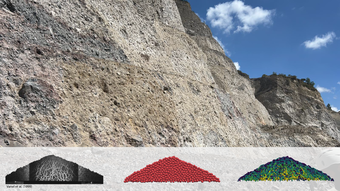
A quantitative evaluation of basal surface shapes to estimate bedrock landslide volumes
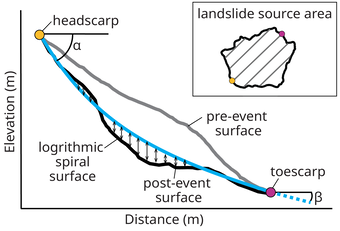
This talk will examine the use of logarithmic spirals and planar or bi-planar geometries to estimate failure surface shapes and volumes of previously documented bedrock landslides. We present an inventory of large rock slides and rock avalanches for which pre- and post-event topography data are available, examine failure surface shapes using post-event topographic data, and evaluate the suitability of different geometries for approximating bedrock landslide failure surfaces and volumes.
February 11, 2026 - Al Handwerger, NASA Jet Propulsion Laboratory
Landslide Detection, Monitoring, and Research Using OPERA Data
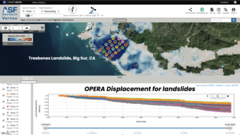
This presentation introduces NASA’s Observational Products for End-Users from Remote Sensing Analysis (OPERA) project and its suite of freely available satellite-derived products. The talk will provide an overview of the OPERA project and products, then demonstrate how these products can be used for landslide detection, monitoring, and scientific research. Examples highlight how OPERA observations enable identification of active landslides, characterization of spatial patterns of motion, and tracking of temporal changes relevant to landslides.
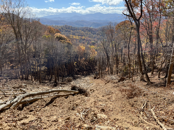
January 28, 2026 - Katy Barnhart, U.S. Geological Survey
Multi-site evaluation of a postfire debris-flow runout forecast method

Postfire debris flows pose a hazard to human life, property, and infrastructure when they travel from steep source areas to urbanized alluvial fans or other developed areas. Existing methods for rapid (< 1 week) postfire debris-flow hazard assessment document the increase in the likelihood and size of debris flows as the magnitude of high-intensity rain necessary to initiate debris flows increases but do not indicate the extent of downstream debris-flow runout. Although many models for the simulation of debris-flow motion are available, there is no established approach for using these models to delineate locations susceptible to postfire debris-flow runout that (1) is feasible to use at the spatial scale of an entire fire; (2) is appropriate for runout onto unconfined areas; (3) reproduces observed relations between runout and rainfall intensity; and (4) characterizes inherent uncertainty in runout, even without spatiotemporally variable rainfall. We propose and evaluate a method for generating postfire debris-flow runout hazard maps that has all the above qualities. Selection of case studies prioritized events triggered by a range of rainfall intensities, locations within and outside of southern California, and observed runout onto unconfined topography. Qualitative and quantitative assessment of performance for four events indicate that simulation results broadly match observations albeit with some discrepancies at a scale larger than structure or land parcel level (approximately 20-m by 20-m). The method may be used to identify potentially hazardous areas immediately following a fire and to provide approximate runout forecasts when a storm is imminent.
January 21, 2026 - Mario Ernesto Reyes Martínez, Observatory of Hazards and Natural Resources of the Ministry of Environment of El Salvador
Landslide susceptibility mapping in El Salvador
This presentation shows the preliminary results of a landslide susceptibility model developed for El Salvador. The model was created as part of a collaboration between the Ministry of Environment and Natural Resources of El Salvador and the U.S. Geological Survey (USGS). The XGBoost algorithm was used to build a statistical model to predict landslide occurrence, using slope units as the mapping units. The results show good agreement between the model predictions and the dataset used for validation. This model is expected to support improved landslide risk management in El Salvador.
November 19, 2025 - Seulgi Moon, UCLA
Deep critical zone controls on shallow landslides
Shallow landslides typically involving just the soil mantle constitute both a primary process driving landscape evolution and a significant geologic hazard. Theory for and empirical documentation of shallow landslides generally assumes that the elevated pore pressures that destabilize soils arise from runoff just within the soil. In many landscapes, however, it has been recognized that groundwater emerging from underlying weathered bedrock can generate destabilizing pore pressures. Here, we develop a coupled hydrologic and slope stability model that explicitly explores how a conductive bedrock weathering zone guides storm runoff and localizes shallow landslides across a watershed. Our findings suggest that first-order variations of deep CZ can provide physical explanations for variations observed in the susceptibility, magnitude, and timing of shallow landslides, and that CZ structure may be inferred from patterns and timing of landsliding.
September 24, 2025 - Marisa C. Palucis, Dartmouth College
Landslide and debris flow response to past and present climate change in the Canadian Arctics
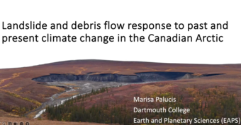
Arctic landscapes are among the most vulnerable on Earth to climate change, largely due to the rapid degradation of permafrost. In steeper bedrock-dominated terrains, warming permafrost can lead to increased sediment production via mass wasting events and amplify the delivery of sediment to channels and lakes. However, there is a fundamental lack of data on current rates of sediment production and transport in Arctic watersheds, especially those still responding to post-glacial perturbations, making it impossible to predict the responses and rates of sediment transport processes under future climate change. In this talk, I will present findings from a field-based study of the Black Mountain catchment in the Aklavik Range (Canada). This site was chosen due to the presence of an alluvial fan that post-dates the retreat of the Laurentide Ice Sheet (LIS), providing a closed system where we can consider how both paraglacial and periglacial mass flow processes have influenced physical weathering and transport rates through time.
September 17, 2025 - Jacob Woodard, U.S. Geological Survey
Tools for more reliable regional landslide risk reduction products
Regional-scale (>500 km2) landslide risk reduction models often suffer from their reliance on difficult-to-obtain data, such as inventories of past landslide locations or geomechanical properties of the hillslopes. However, over regional scales, these data are often sparse, inconsistent, and nonrepresentative, which can lead to biased model outputs. In this talk, I will present two recent studies that help overcome these challenges. First, I will share a method of assessing shallow landslide susceptibility based on a morphometric analysis of the landscape’s topography. Despite having no knowledge of past landslide locations, the morphometric approach can better characterize landslide potential over contrasting data-driven models that are generally used for assessing regional-scale landslide susceptibility. Second, I will present a Bayesian statistical comparison of common metrics used to predict rainfall-triggered landsliding across disparate regions of the United States. I will show that parsimonious leaky-bucket models, whose only inputs are a drainage constant and estimates of precipitation, can better distinguish landslide-triggering rainfall from non-landslide-triggering rainfall compared to traditional rainfall metrics or more complex models. The leaky-bucket model had the best performance across vastly different environments within the United States, suggesting that it may be used universally to enhance regional-scale landslide risk reduction efforts.
August 27, 2025 - Josh Roering, University of Oregon
Bedrock ledges, colluvial wedges, and ridgetop water towers: Characterizing the 2023 Wrangell landslide to inform landslide assessment in Southeast Alaska, USA
In the past decade, several fatal landslides have impacted Southeast Alaska, highlighting the need to advance our understanding of regional geomorphic and atmospheric controls on triggering events and runout behavior. A large and long runout landslide on Wrangell Island, with area in the top 0.5% of >14,760 slides mapped in the Tongass National Forest, initiated during an atmospheric river event in November 2023 and traveled >1 km downslope, causing six fatalities. We used field observations, sequential airborne lidar, geotechnical analyses, and climate data to characterize the geomorphic, hydrologic, and atmospheric conditions contributing to the landslide. Rainfall intensities recorded at the Wrangell airport were modest (~1-yr recurrence interval), but rapid snowmelt and drainage from a ridgetop wetland may have contributed to rapid saturation of the landslide. Although strong winds were recorded, we did not observe extensive windthrow, which may downgrade its contribution to slope failure. The landslide mobilized a steep, thick (>4 m) wedge of colluvium that accumulated below a resistant bedrock ledge and entrained additional colluvial deposits as it traveled downslope across cliff-bench topography. The substantial entrainment resulted in an unusually large width, extensive runout, and low depositional slope as the landslide terminated in the coastal environment. Our results suggest that the sequencing of rain- and snow-dominated storms, geologic controls on post-glacial colluvium production and accumulation, and ridgetop hydrology contributed to landslide initiation and mobility. Advances in post-glacial landscape evolution models, frequent lidar acquisition, and additional climate data are needed to inform regional landslide hazard assessment.
August 13, 2025 - Adam Booth, Portland State University
Permafrost and structural controls on Holocene bedrock landslide occurrence around Eyjafjörður, north-central Iceland
As glaciers recede and expose mountain slopes that were previously covered by ice, dramatic changes in the forces acting on those slopes occur. Those changing forces can trigger large bedrock landslides, which are potentially hazardous to humans and also play a role in sculpting landscapes over longer geologic time scales. Although changing conditions and their connection to landslides can be monitored in real-time at some locations, it is challenging to determine the mechanisms responsible for generating prehistoric landslides. In this study, we mapped and analyzed 676 landslides in north-central Iceland that occurred after the Icelandic Ice Sheet retreated and exposed the underlying land surface beginning about 13,000 years ago. Landslides did not occur randomly across the landscape; they instead clustered near zones of weaker rocks and near the margins of high elevation permafrost zones. In addition, about 90% of the landslides likely occurred several thousand years after the ice sheet retreated, during a time in which permafrost was rapidly degrading under warmer temperatures. These results imply that thawing permafrost was an important trigger of large landslides in the past and may become an important trigger again as ongoing warming and permafrost degradation in Iceland continues
July 30, 2025 - Arthur Merschat, U.S. Geological Survey
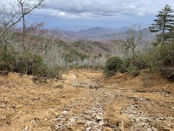
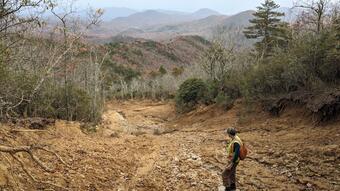
Field observations of landslides from Hurricane Helene in the Blue Ridge of northwestern North Carolina and northeastern Tennessee
Hurricane Helene devastated western North Carolina and parts of surrounding Tennessee and Virginia. A stalled front over the Blue Ridge prior to landfall of the hurricane resulted in cumulative rainfall totals of 20–30 inches from Sept. 25–27, 2024. This triggered numerous landslides and devastating flooding, and has changed the landscape of the Blue Ridge and mountain communities. This mapping and assessment of the landslides was conducted as part of the USGS Landslide Assessments, Situational Awareness and Event Response Research (LASER) and in cooperation with the North Carolina Geological Survey Landslide Hazard Program. Mapping efforts focused on the northernmost area heavily impacted from the storm: parts of Watauga, Avery, and Ashe County, NC, and parts of Johnson County, TN. Initial observational descriptions of the landslides are presented. Landslides mapped are separated into three type occurrences, hyperconcentrated earth flows, debris flows, and modified slope failures. Earth flows occurred on steep grassed slopes and consisted of soil with a mixture of vegetated clumps, saprolite, and rock. The landslide tracks were 10–338 m long, and scarp widths of 10–30 m that often cut down 1–2 m to bedrock. Earth flows often occurred in clusters, and some merged down slope. Debris flows had longer tracks, 96–1085 m, and consisted of a mixture of soil, rock, trees, vegetation, and other debris. Head scarps were 10–114 m wide and cut down through 1–3 m of colluvium to bedrock. Bedrock structures controlling the failures included joints, fractures, and foliation. Seven debris flows on Howards Creek initiated on steep slopes with aspect and slope close to the orientation of the foliation in bedrock (330/20–40° NE). Modified slope failures included landslides that initiated on road cuts, road embankments, steep cut slopes, and other slopes modified by construction (e.g., failed drainages or septic fields). Although the slope modification was important to initiate these slides, some localized along preexisting bedrock (saprolite) structures. Collectively, the impact of landslides from Hurricane Helene highlights the importance of basic geologic mapping and landslide assessment to build robust datasets to better understand and model the occurrence of landslides and strengthen our planning and rebuilding of mountain communities.
July 16, 2025 - Will Struble, University of Houston
Debris-flow dominated landscapes: morphologic proxies for long-term uplift and erosion rates?
Fluvial channel steepness and hilltop curvature are commonly used as proxies for erosion rate in equilibrium landscapes, but they become less reliable in rocky steeplands dominated by debris flows. We explore an alternative metric—Adf, the drainage area at which valleys transition from slope-invariant to fluvial power-law slope-area scaling—and show that it correlates with erosion rates in several regions. Combining field data with a landform evolution model, we demonstrate that Adf provides insight into where debris-flow processes dominate, and we constrain a physically meaningful debris-flow incision law that offers new insight into how steep landscapes evolve under varying climatic and tectonic conditions.
June 25, 2025 - Noah Finnegan, University of California, Santa Cruz
Insights into the frictional rheology and hydrology of a rock slope instability from in-situ monitoring near Columbia Glacier, Prince William Sound, Alaska
Since 2023 we have instrumented a large, creeping bedrock landslide near the calving face of Columbia glacier in Prince William Sound, Alaska. With an eye towards better mitigating the hazards associated with large rock slope instabilities in coastal Alaska, I will highlight some of what we have learned about the mechanical and hydrological behavior of this landslide from our instrumentation
June 11, 2025 - Hunter Jimenez, University of Washington
Probabilistic Landslide Hazard Assessment of the 2023 Türkiye–Syria Earthquake and Subsequent Atmospheric River
On February 6, 2023, a Mw 7.8 and Mw 7.5 earthquake doublet struck along the East Anatolian Fault Zone in Türkiye, triggering over 3,600 coseismic landslides. Roughly a month later, a rare atmospheric river event delivered up to 183 mm of rainfall in just 20 hours to the earthquake impacted region. This extreme precipitation induced additional landslides, debris flows, and flooding.
In our research, we conduct a probabilistic landslide hazard assessment using the open-source Landlab earth surface modeling library, integrating both seismic and climatic drivers. The model incorporates earthquake legacy effects, representing post-seismic slope weakening, and simulates shallow landslide susceptibility using a Monte Carlo implementation of the infinite slope stability theorem informed by remote sensing datasets.
I will present three key analyses: (1) modeling hydrologic response to the AR event and mapping landslide probability with and without earthquake legacy effects; (2) examining how the sequence and combination of extreme events alter landslide hazard; and (3) demonstrating how using historic climate data can effectively replicate post-seismic landslide hazard maps that use real-time data, offering an approach for seasonal hazard forecasting in tectonically active and climate-sensitive regions.
May 28, 2025 - Jean Dixon, Montana State University
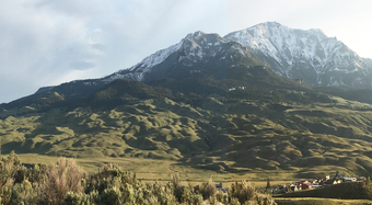
Landslides at the Northern Edge of Yellowstone -- Where, When, and Why?
May 21, 2025 - Dual presentation
Francis Rengers, U.S. Geological Survey
Debris Flow Deposition: Where and Why?
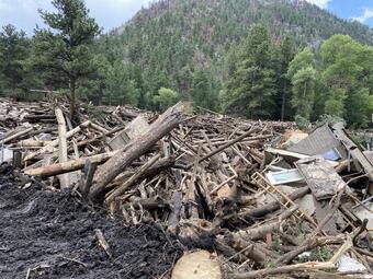
Creating an accurate appraisal of debris flow hazards in burned areas is dependent upon correctly predicting the total volume of sediment that will be transported in potential debris flows. This study focuses on a post-wildfire debris flow in the Black Hollow watershed (17 km2), which burned in the 2020 Cameron Peak wildfire. The debris flow on 20 July 2021 resulted in four fatalities and a large fish kill that wiped out the trout population for 100 km downstream in the Cache La Poudre River. We examined the in-channel sediment dynamics using airborne lidar data collected in August/September 2020 and again in August 2021. Field and lidar data suggest that the vast majority of sediment was supplied from in-channel erosion; however, local patches of hillslope showed signs of extensive rilling. In addition, the lidar-derived channel elevation difference reveals zones of alternating erosion and deposition, such that the net sediment volume reaching the watershed outlet was a fraction of the total volume that was eroded and internally deposited. We identified two primary mechanisms controlling transitions between erosion and deposition in the channel: channel widening and large wood jams. Moreover, field observations combined with lidar differencing suggest that the debris flow discharge downstream may have been amplified by a temporary wooden dam that formed and subsequently broke during the rainstorm. This case study contributes to the larger goal of more accurately predicting the volume of sediment that can be expected at the outlet of burned watersheds by accounting for potential in-channel storage mechanisms.
Georgie Bennett, University of Exeter
Landslide-channel feedbacks amplify channel widening during floods
Channel widening is a major hazard during floods, particularly in confined mountainous catchments. However, channel widening during floods is not well understood and not always explained by hydraulic variables alone. Floods in mountainous regions often coincide with landslides triggered by heavy rainfall, yet landslide-channel interactions during a flood event are not well known or documented. Here we demonstrate with an example from the Great Colorado Flood in 2013, a 1000 year precipitation event, how landslide-channel feedbacks can substantially amplify channel widening and flood risk. We use a combination of DEM differencing, field analysis, and multiphase flow modeling to document landslide-channel interaction during the flood event in which sediment delivered by landslides temporarily dammed the channel before failing and generating substantial channel widening. We propose that such landslide-flood interactions will become increasingly important to account for in flood hazard assessment as flooding and landsliding both increase with extreme rainfall under climate change.
Bennett, G.L., Panici, D., Rengers, F.K. et al. Landslide-channel feedbacks amplify channel widening during floods. npj Nat. Hazards 2, 7 (2025). https://doi.org/10.1038/s44304-025-00059-6”
May 14, 2025, Philip Prince, Appalachian Landslide Consultants
Melting mountainsides: The debris flows and "blowouts" of Hurricane Helene
Extreme rainfall (up to ~75 cm) prior to and during the passage of Hurricane Helene’s remnants generated catastrophic landslide activity in the rough topography of the southern Appalachian Blue Ridge. Due to saturated hillslope conditions, debris flow and “blowout” (flow-slide) landslides predominated during this extreme precipitation event, with substantial loss of life and property damage resulting from slide material entering populated areas. Both debris flows and blowouts mobilized colluvium stored on slopes, with debris flows transporting substantial volumes of colluvial soil well downslope and into the drainage network. Non- or minimally-erosive “blowout” slides, though less volumetrically significant, were observed to be highly mobile and potentially hazardous despite mobilizing less colluvial soil over shorter distances. Debris flows and blowouts initiated on both natural and modified slopes, with embankment failures representing a significant source of debris flow initiation during the event. Field work by Appalachian Landslide Consultants personnel has provided additional understanding of details of debris flow and blowout initiation and downslope movement, including potential influences of bedrock lithology and structure and associated soil type on initiation and mobility of fluidized slides. Comparison of detailed post-event aerial photography to pre-existing LiDAR imagery offers further insight into the hillslope settings of debris flow and blowout initiation. These data will generate useful inputs for ongoing modeling efforts to support regional preparedness, with debris flow (or blowout) runout modeling representing a particularly important direction of study necessary to mitigating impacts of future events.
April 30, 2025, Jennifer Bauer, Appalachian Landslide Consultants
Landslide Maps as a Life-Saving Tool - using Helene-triggered landslides to increase understanding and awareness
On September 26-27, 2024, a Predecessor Rainfall Event, followed by the remnants of Hurricane Helene, passed over the southern Appalachians. Heavy rainfall was concentrated along the high peaks of the Blue Ridge Escarpment and other high-elevation ranges in western North Carolina (WNC). After the storm passed and communications began to be reestablished, geologists with Appalachian Landslide Consultants, PLLC (ALC) began responding to requests for landslide evaluations in WNC. Through these requests from the NC Geological Survey, county Emergency Management, the NC Department of Transportation, as well as private individuals, geologists began to collect empirical observations from the dozens of slope movements visited. The majority of these are classified as debris flows, debris blowouts, or debris or weathered rock slides. These features occur on non-constructed slopes, as well as on constructed cut or fill embankment slopes. Surface and groundwater played a large role in their initiation, as observed by surface overwash and erosion patterns as well as groundwater “macropore” features. Several of these features occurred where landslides have happened in the past, once again reminding us that past events may inform where future events may occur. Many occurred within modeled landslide susceptibility areas.
April 23, 2025, Lauren Schaefer and Ben Mirus, U.S. Geological Survey
Widespread landslides across southern Appalachia following Hurricane Helene: emergency response, initial observations, and historical context
Between the 23rd–27th of September 2024, antecedent rain followed by Hurricane Helene produced widespread flooding and landsliding across southern Appalachia, resulting in one of the most damaging weather events in the region’s history. The back-to-back storms produced observed rainfall accumulations of up to 848 mm and hurricane-force winds gusting over 200 kilometers per hour in western North Carolina, eastern Tennessee, and southwestern Virginia. The resulting regional flooding, landslides, and tree blowdown caused over 100 fatalities, damaged or destroyed critical infrastructure and thousands of structures, and severed connectivity across the region. Together with state, federal, and local partners, the U.S. Geological Survey activated their landslide emergency response team to coordinate rapid remote, aerial, and field mapping of landslides and impacts, hazard modeling and assessments, daily situational reports, and development of educational and outreach materials. These efforts provided timely information to aid emergency response, and initial observations highlight strong aspect and topographic controls as well as the importance of total rainfall accumulation on landslide initiation. Subsequent post-event investigations suggest that further research is needed to understand spatial clustering of landslide initiation, controls on landslide and debris flow runout, discrepancies between preliminary mapping and hazard models, and how to more effectively inform at-risk populations about potential landslide impacts.
April 16, 2025, Sean LaHusen, U.S. Geological Survey
Geologic Controls on Deep-Seated Landslides

The frequency and scale of landslides in a region are determined by both external forcing and inherent, site-specific susceptibility. During potential triggering events like earthquakes, prolonged periods of elevated pore water pressure, or slope debuttressing, the geotechnical properties of the bedrock ultimately govern whether a hillslope fails as a deep-seated landslide and influence the landslide failure style and kinematics. Although mapped geology is regularly used as a predictor variable for landslide susceptibility models, it is often insufficient in characterizing the nuanced ways in which lithology, stratigraphy, and discontinuities interact to determine how slopes fail in landscapes underlain by heterogenous, fractured bedrock. Using case studies in the Pacific Northwest U.S. and Alaska, I hope to demonstrate that by incorporating more detailed geologic information into regional landslide assessments, we can develop a more complete understanding of the controls on landslide volume, location, and failure style.
April 9, 2025, Guo Yu, Desert Research Institute
Wildfire Continuum Flood Frequency Analysis

Moderate- to high-severity wildfire can abruptly alter watershed properties, which intensifies extreme hydrologic responses such as debris flow and flooding. Understanding the frequency and severity of such compound wildfire-flood hazards is of growing importance, particularly in wildfire-prone regions. However, standard statistical flood frequency analysis approaches are ill-suited to examining this issue because wildfire-affected peak flow observations are limited in number and violate the assumption of independent and identically distributed events. In this study, we propose a process-based framework to derive flood frequency that accounts for the range of possible flood responses to a continuum of watershed conditions, from the pre-wildfire conditions to the perturbed state immediately after a wildfire to the post-wildfire recovery conditions
March 26, 2025, Carie-Ann Hancock, BGC Engineering
Contributing factors for landslides triggered by the November 2021 atmospheric river in British Columbia, Canada

More than a thousand geohazards were triggered by the mid-November 2021 atmospheric river in southern BC, Canada. We examined the contributing role of forest disturbances from wildfires, logging, and resource roads on the location of landslides. Geohazards occurred more frequently in burned areas and along forest harvesting resource roads, providing point sources of sediment that entered mainstem rivers. Geohazard mapping and lidar change detection revealed that bank erosion and lateral instability often occurred downstream of these mapped sediment sources.
March 19, 2025, Sergio Sepúlveda, Simon Fraser University
Understanding large rock slides in deglaciated valleys in the Central and Patagonian Andes

The effects of deglaciation on the slope stability of glacial valleys have increasing importance in the context of climate change, with a role on the susceptibility to large-volume rock slides or rock avalanches and catastrophic cascading geohazards. In this talk, we review case studies in the Central and Patagonian Andes of Chile, including two fatal historic events (Parraguirre 1987 and Santa Lucia 2017), and other older and active landslides in which the effects of deglaciation are proposed to be major control in the instability of the rock slopes. This work uses 2D and 3D geotechnical numerical modeling approaches, combined with remote sensing and structural analyses, to improve understanding of how stress state changes linked to deglaciation induce rock damage and progressive failure mechanisms, in combination with lithological or structural controls and climatic triggers. The results provide meaningful information towards a better understanding of the behavior of rock slopes under paraglacial conditions, which are of critical importance for the design of monitoring and detection tools for geohazard assessment strategies in remote, high-mountain areas along the Andean range and other Cordilleran settings.
March 12, 2025, Paul Morgan, The University of Washington, Seattle
The damability function: A probabilistic approach to regional landslide dam susceptibility analysis applied to the Oregon Coast Range, USA

Landslides can dam rivers and require rapid response to mitigate catastrophic outburst floods. In this talk I will describe what landslide dams are including a few recent examples, and present a workflow to map landslide dam formation susceptibility at a regional scale. We define a probabilistic function that combines river valley width and landslide volume to efficiently determine the likelihood of a landslide dam or ‘damability’. We combine damability values with landslide susceptibility to find landslide dam susceptibility. We verify and apply our approach to the Oregon Coast Range, USA and find high susceptibility in river headwaters and generally steeper terrain, which in this case correlates with more resistant lithologies. We also estimate volumes of the potential dammed lakes and find that most rivers with high dam susceptibility are less likely to impound large lakes, because they have low drainage areas. However, widespread susceptibility, and the critical potential impacts from exceptionally large landslides, suggest this hazard should be considered in the Pacific Northwest. The damability function workflow can readily ingest new data and can be applied more broadly to assess future landslide dam hazards.
February 19, 2025, Yuankun Xu, University of California, Berkeley
Remote sensing and hydromechanical characterization of landslides

Yuankun Xu presents his research on landslides, focusing on how surface processes can be better understood using a combination of remote sensing, GPS, field instrumentation, and numerical modeling. His talk emphasizes the importance of integrating multiple methods to analyze landslide mechanics and hydrology, with specific case studies to demonstrate how surface movements correlate with subsurface hydromechanical processes.
February 12, 2025, Liam Toney, U.S. Geological Survey
Seismic and atmospheric acoustic waves reveal the dynamics of a large rock–ice avalanche in Denali National Park

In September 2023, a large rock–ice avalanche occurred in Denali National Park at Peters Dome, just 12 km from the summit of Denali. This landslide was well-recorded by Alaska’s robust geophysical sensor network, and it was reconnoitered by park staff on a fixed-wing flight the following day. In this talk, I’ll introduce seismology and infrasound (low-frequency atmospheric acoustics) as landslide monitoring tools. I’ll present the well-constrained Denali event as a showcase for the variety and quality of information we can rapidly and remotely obtain from these wiggles. I’ll conclude with some discussion of how seismology and infrasound might further contribute to future rapid landslide responses and ongoing monitoring efforts.
January 29, 2025, Jan Blahůt , Czech Academy of Sciences
When Rocks Heat Up: The Impact of Temperature on Rock Properties

This presentation discusses how temperature changes affect the properties of rocks and what that means for slope stability. It specifically looks at how wildfires in Czechia have altered rock properties. Additionally, it includes findings from research in Yosemite that investigates effects in a much cooler temperature range.
January 15, 2025, Colleen Murphy, U.S. Geological Survey
Impacts of increasing precipitation variability on landslide triggering in the San Francisco Bay Area (California, USA) due to climate change

Generation of sufficient soil pore-water pressure to trigger failure of rainfall-induced landslides depends on the combination of antecedent soil moisture and the intensity and duration of infiltrating rainfall during the triggering storm. Precipitation extremes and volatility are both projected to intensify in the future due to climate change, particularly in California (USA), which already experiences considerable interannual variability relative to the rest of the country as well as distinct seasonality. The effects of these changes on rainfall-induced landslides are not straightforward. Nominally, increasing precipitation intensities lead to more landslides, however above a certain threshold the efficacy will decrease as precipitation gets diverted from infiltration to runoff due to infiltration excess. Additionally, antecedent soil moisture conditions are likely to be affected by rising temperatures and changes in the timing and sequencing of storms relative to present. Here we explore the potential effects of these changes on landslide activity in the San Francisco Bay area using an ensemble of downscaled climate projections coupled to a 1-D hydrological model of transient, variably saturated flow in a 2-layer system. We first calibrate the model to site-specific groundwater observations and identify landslide days based on empirical hydrological thresholds. We then apply the model chain to historical and future (1950-2100) climate projections to assess changes in the characteristics and frequency of landslide triggering conditions due to the interplay of intensifying precipitation, rising temperatures, and changes in the frequency and timing of precipitation events. For shallow landslides, we project an increase in the frequency of both extreme landslide years and years with no landslide days at all, as well as a small increase the average annual number of landslide days overall.
November 20, 2024, Maryn Sanders, University of Oregon, and David Sousa, Oregon State University
Controls on post-fire debris flows in Oregon

Wildfire often amplifies the likelihood and magnitude of debris flows in steep terrain. In arid climates (e.g. US Mountain West and Southwest), post-fire debris flows typically occur during the first rains following fire, suggesting that rainfall-driven erosion is a strong control on in-channel preconditioning and triggering of these hazards. However, in the humid and forested steeplands of the Pacific Northwest, there is an apparent lag between cessation of burning and debris flow occurrence that suggests controls differ from drier climates. Preliminary results suggest that post-fire debris flows in Western Oregon are associated with the delayed triggering of shallow landslides and in-channel bed failures years after burning. David and Maryn are working to evaluate the spatiotemporal controls on post-fire debris-flow initiation and their impact on transportation infrastructure. Their respective research focuses on the physical characterization of root strength following wildfire and quantification of fire-related debris flow erosion relative to the long-term evolution of the Columbia River Gorge, OR.
November 13, 2024, Jonathan King, U.S. Geological Survey
Building an operational framework for postfire debris-flow hazard assessments

Recently burned landscapes are often at elevated risk for debris-flows. To address this, the USGS releases over 50 postfire debris-flow hazard assessments each year, and these assessments are used by stakeholders, emergency managers, and the public to inform postfire response. In this talk, we will discuss recent efforts to modernize the operational framework for producing these assessments. Previously, the USGS relied on a collection of research codes, but these were not open source, were prone to breaking, and struggled to handle assessments for large fires. In the last year, we have converted these research codes to a collection of open-source software tools designed for a variety of users and use cases. These include the “pfdf” Python library, the “wildcat” assessment tool, and the USGS’s in-house operational codebase. We’ll provide a brief introduction to each of these tools, and then discuss future planned developments for the operational framework.
October 9, 2024, Chuxuan Li, UCLA
Use of WRF-Hydro to identify landslide-susceptible areas at regional scales

Landslide-triggering weather systems often operate on expansive spatial scales, causing widespread landsliding activity. Diverse landslide-conditioning factors, such as wildfires, antecedent soil moisture, and snowpack, within these weather systems' extensive footprints, along with complex dynamic interactions, make regional landslide susceptibility prediction increasingly challenging and in need of multidisciplinary approaches. Here, I argue that regional hydrometeorology, which integrates atmospheric, hydrologic, and geomorphic processes, is key to advancing large-scale landslide susceptibility prediction. This presentation introduces a methodological framework for identifying landslide-prone areas at regional scales using physics-based hydrological simulations from WRF-Hydro. It begins by demonstrating WRF-Hydro's ability to simulate landslide-relevant variables, such as soil moisture and streamflow, over a regional domain in California. Next, it presents a case study on numerous postfire debris flows triggered by an atmospheric river along the central Californian coast. Lastly, a case study on widespread landsliding activity caused by the parade of nine atmospheric rivers during the 2022-2023 winter season in California will be presented.
September 18, 2024, Bill Burns, Oregon Department of Geology and Mineral Industry
Using multitemporal lidar to better understand landslide and debris-flow hazards in western Oregon

In 2017, the Eagle Creek fire scorched the western portion of the Oregon side of the Columbia Rive Gorge (CRG). In 2021 and 2022 atmospheric river type storms triggered many post-fire debris flows. The purpose of this research/paper is to evaluate pre- and post-2017 Eagle Creek Fire debris flows in the WCRG (western Columbia River Gorge) study area using multi-temporal bare earth lidar digital elevation model. To understand the difference between pre-fire debris flows and post-fire debris flows in the WCRG, multiple sources of data were collected and analyzed. The primary data sets were field data collected after storms, orthophotos, and the multitemporal lidar data sets used to map the debris flows.
August 21, 2024, Jonathan Perkins, U.S. Geological Survey
Characterizing the scale of regional landslide triggering in California from storm hydrometeorology

Landslides are a global issue that results in deaths and economic losses annually. However, it is not clear how storm severity relates to landslide severity across large regions. Here we develop a method to estimate the footprint of landslide area and compare this to meteorologic estimates of storm severity. We find that total storm strength does not clearly relate to landslide area. Rather, landslide area depends on soil wetness and smaller storm structures that can produce intense rainfall.
August 14, 2024, Philip Prince, Appalachian Landslide Consultants
Blockslides, summit grabens, and collapsing highwalls of the Appalachian Valley and Ridge: Using lidar-derived imagery to reevaluate a thoroughly studied landscape

In the mid-1980s, Art Schultz (USGS, ret.) drew on experiences in the Colorado Front Range to identify numerous large, stratigraphically intact, kilometer-scale bedrock landslides on interbedded sandstone-shale dip slopes in the Virginia Valley and Ridge. The physical scale of the slides, along with the thick forest cover, made slide identification challenging, as slides could easily be mistaken for compressional fold-thrust features detached in shale horizons. As a result, the distribution and extent of blocksliding could not be fully evaluated at the time. Revisiting Valley and Ridge slopes with newly available 1-meter lidar datasets highlights the ubiquity of dip slope failure in the central and southern Appalachian Valley and Ridge, with many slides showing morphological features that imply relative youth. In addition to translational blockslides, lidar-derived imagery reveals numerous sackungen in rugged topography developed on gently dipping, interbedded sandstone-shale ridges. Abandoned late 19th and early 20th century iron mines on intact slopes in the vicinity of large blockslides show deep-seated slope movement almost certainly related to mine excavations. The extent of these movements relative to excavation size suggests that caprock-supported rugged topography in the Valley and Ridge may exist at or near the mechanical limit of weaker strata interbedded within the caprock interval. Lidar-supported investigation of Valley and Ridge bedrock slope movements invites reflection on the interpretive skill of Schultz and collaborators and a reconsideration of how potential slope behavior may impact infrastructure in the region..
July 24, 2024, Brittany Selander, U.S. Geological Survey
Impacts of wildfire on debris-flow hazards in Oregon’s western Cascade Range

In the steep and mountainous environment of western Oregon, debris flows pose a significant threat to property, infrastructure, and life. Wildfire increases the susceptibility of steep slopes to debris flow. The USGS estimates postfire debris-flow likelihood and triggering rainfall thresholds using the M1 postfire debris-flow likelihood model. This model was calibrated with data from southern California, where postfire debris flows typically initiate from distributed runoff and erosion. Due to a lack of available data, the likelihood model has not been tested in western Oregon, or in locations where postfire debris flows initiate via other mechanisms (e.g., shallow landslides or in-channel failures). Using repeat field observations and aerial imagery, we developed two new debris-flow inventories within, and adjacent to, the perimeters of five 2020 wildfires in western Oregon: Archie Creek, Holiday Farm, Beachie Creek, Lionshead, and Riverside. The first inventory focuses on debris flows prior to fires (1995-2020); the second focuses on postfire debris flows (2020-2022). Using these pre- and postfire inventories, we investigate how wildfire alters the initiation and frequency of debris flows. We additionally test the performance of the postfire debris-flow likelihood model. In this talk will summarize what we have learned about postfire debris-flow hazards in Oregon's western Cascade Range.
July 17, 2024, Matthew Morriss, Utah Geological Survey
Insights from the Chaos Canyon landslide, Rocky Mountain National Park

This study investigates the Chaos Canyon landslide that occurred on June 28, 2022, in Rocky Mountain National Park. Wes ought to understand the factors contributing to alpine instabilities in a changing climate. Using satellite data, field observations, and climate analysis, we examined the landslide's movement history, volume, and potential causes. A mix of empirical and model based evidence suggests that permafrost thaw, weakened basal shear zone, and increased pore-fluid pressure from snowmelt led to the collapse. The researchers estimate the volume of displaced material and discuss the implications for future alpine topography in warming climates. Through detailed mapping and SfM models we estimate that ∼1 258 000 ± 150 000 m^3 of material was deposited at the slide toe and ∼1 340 000 ± 133 000 m^3 of material was evacuated from the source area. In a warming climate, landslides like this may be representative of future dynamic alpine topography.
July 10, 2024, Shelby Ahrendt, U.S. Geological Survey
Feedbacks between river meandering and landsliding in northwestern Washington glacial outwash terraces

Landslides that occur in river valleys can be large, highly mobile, and cause cascading downstream hazards associated with landslide dams and elevated flood risk. However, the role of rivers in triggering landslides is not well understood: are there spatial and temporal patterns in river geometry leading up to major landslide events? Additionally, how does river geometry respond to deep-seated landsliding?
This talk investigates river-landslide feedbacks in the Nooksack River in western Washington State where the channel is flanked by landslide-prone glacial terraces that are similar to those that failed in the deadly 2014 Oso landslide. We show that landsliding and river meandering can be dynamically coupled: deep-seated landslides can “push” the river away from the floodplain margin, creating a new up- or downstream river meander. This new meander erodes the adjacent terrace, triggering a secondary landslide. This conceptual model has ramifications for improving hazard management in river corridors as well as informing fundamental understandings of the river-hillslope interface in landscape evolution..
June 26, 2024, Paul Burgess, California Geological Survey
CGS response to landsliding during the 2023 – 2024 winter storm season in California

From mid November 2023 until late March 2024, sixteen atmospheric river events impacted California, resulting in water year-to-date precipitation accumulations varying from more than 200 to 300% above average across selected areas of the state. Similar to the 2022 – 2023 winter storm season, California experienced historic flooding and multi-modal landslide activity that damaged transportation infrastructure, homes, property, and threatened life-safety and economic welfare across the state. California Geological Survey (CGS) staff worked to provide situational awareness of statewide landslide hazards to the State Geologist through partnership with various government and community sources. CGS leveraged its Reported Landslides Database (RLD) mapping tools for desktop and field surveying to rapidly identify areas of observed landslide impacts. The RLD mapping team identified more than 600 landslides, resulting in deployment of field teams to provide further assistance to hardest hit areas. CGS utilized these data to guide ongoing support of partner agency response to landslide hazards statewide.
This talk will explore how the RLD can be applied as a tool before during and after landslide response work, and also highlight some particularly notable landslide events that occurred in California this past winter.
June 12, 2024, Ben Mirus, U.S. Geological Survey
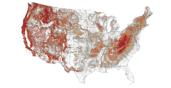
Parsimonious landslide susceptibility modeling at continental scales: a new high-resolution national landslides map

Landslide susceptibility maps are a fundamental tool for risk reduction. We used the USGS's landslide inventory compilation (N=613,724), high-resolution 3DEP digital elevation model (~10-m), and high-performance computing resources (YETI), to develop a new nation-wide susceptibility map for the Continental U.S., Hawaii, Alaska, and Puerto Rico. We used a parsimonious slope-relief threshold approach to distinguish between areas with some landslide potential from those with none, then down-sample our results to a 90-meter grid to account for uncertainty in the DEM, landslide position, and other factors. In addition to our rigorous 70/30 split-sample calibration and evaluation with multiple iterations, an independent validation with four statewide inventories (N=172,367) further reinforces the robustness of our threshold model, but also highlights spatially variable performance. Therefore, we propose a novel approach to susceptibility classification using the concentration of landslide-prone terrain within each down-sampled grid. While landslides are possible within any cells containing susceptible terrain, those with the highest concentration capture the majority of landslides. Our new map is more accurate than prior models; it also provides a transparent and flexible approach to susceptibility classification for implementing different tolerances for landslide risk reduction.
May 15, 2024, Seth Moran, U.S. Geological Survey
The Mount Rainier Lahar Detection System: Risk mitigation for an unlikely, but potentially catastrophic, hazard

Of all the volcanic hazards associated with Mount Rainier, large lahars pose the greatest risk to communities downstream of the volcano—more than 90,000 people live in areas that could be impacted by a future large lahar. Most lahars have been associated with eruptions except for the ~1507 A.D. landslide-initiated Electron Mudflow, for which no evidence of an associated eruption has been found. Recent studies show that the western flank of Mount Rainier could produce future non-eruptive landslides and associated large lahars down the Puyallup and/or Tahoma Creek drainages, potentially reaching nearby small towns within 5-10 minutes and larger communities within 60 minutes.
The Mount Rainier Lahar Detection System (RLDS) is part of a risk-mitigation strategy pursued by a group of local, State, and Federal agencies since 1998. It consists of several components: 1) a real-time network of tens of seismometers, infrasound arrays, tripwires, webcams, and other instruments located on the flanks of the volcano and along vulnerable drainages operated and upgraded periodically by the U.S. Geological Survey (USGS) Cascades Volcano Observatory (CVO) and the Pacific Northwest Seismic Network; 2) an automated detection system, designed and maintained by CVO, that triggers alarms in two separate county- and State-run 24/7 emergency operations centers; and 3) a set of protocols and inter-agency agreements among CVO, Pierce County (Washington) Department of Emergency Management, and the Washington State Emergency Management Division that delineate each agency’s detection, alerting, and/or warning responsibilities, protocols that are reviewed and tested periodically.
This presentation will give a broad overview of the history and current status of the RLDS, including some of the challenges we have faced in achieving operational objectives.
May 8, 2024, Drake Singleton, U.S. Geological Survey
Submarine slope failures associated with the 1964 M9.2 Great Alaska Earthquake in the fjords of southcentral Alaska

The March 27, 1964, Mw 9.2 Great Alaska Earthquake produced strong ground motions across coastal southcentral Alaska. In the fjords of Prince William Sound (PWS), which overlie the 1964 epicenter and rupture area, intense shaking generated widespread destabilization and failure of submerged fjord sediments. Some of these slope failures in turn generated devastating tsunamis that impacted several coastal communities. While sediments in some fjords failed in 1964, others did not, suggesting that a complex interplay between basin physiography, sediment accumulation, and shaking intensity determines the degree of instability that develops within each local fjord depositional system. This talk will highlight observations from a dataset of high-resolution Chirp sub-bottom profiles and shallow gravity cores recently collected across the fjords of southcentral Alaska. Using this dataset, we investigate factors that contributed to observed variations in the 1964 deposit character with the goal of quantifying the relationships between seismic parameters (i.e., shaking intensity), the sedimentary response (i.e., total volume remobilized and thickness of the resulting deposit), and the potential for a particular slide to generate a tsunami.
April 24, 2024, Catherine Pennington and Roxanne Ciurean, British Geological Survey
Stability in motion: an overview of interdisciplinary landslide research at the British Geological Survey

Overview of landslide research at the British Geological Survey.
April 10, 2024, Pukar Amatya, U.S. Geological Survey
Accuracy assessment of rapid response landslide maps generated using open-source tools during the August 2021 Haiti earthquake

A singular heavy rainfall event or earthquake can trigger hundreds to thousands of landslides. The first and most important information that on-the-ground disaster responders need following a major landslide event is information on the location and extent of landslides. Typically, the most used method for rapid landslide identification is manual mapping, a technique that is limiting in space and time. Recent availability of very high-resolution optical imagery and advancement in image processing technologies have significantly improved our ability to map landslides automatically. On August 14, 2021, a Mw 7.2 earthquake struck the Tiburon Peninsula of western Haiti triggering thousands of landslides. Three days after the earthquake on August 17, 2021, Tropical Storm Grace crossed shallow waters offshore of southern Haiti triggering more landslides worsening the situation. In the aftermath of these events, several organizations with disaster response capabilities or programs activated to provide information on the location of landslides to first responders on the ground. The 2021 Haiti event provided a unique opportunity to test different automated landslide detection methods that utilized both SAR and optical data in a rapid response scenario where rapid situational awareness was critical. As the methods used are highly replicable, I will be presenting on the landslide rapid response products released by the organizations, detection methods, accuracy quantification and guidelines on how some of the shortcomings encountered in this effort might be addressed in the future.
March 20, 2024, Sabrina Martinez, U.S. Geological Survey
Variations in population exposure to landslides within the United States

The 2021 National Landslide Preparedness Act directs the United States Department of the Interior to identify and understand hazards and societal risks posed by landslides across the country. However, a consistent and nationwide understanding of the societal risk posed by landslides does not exist. We attempt to fill this gap by characterizing exposure to landslides across the country using gridded 90-meter resolution landslide susceptibility and population models. The susceptibility model describes where landslides are more and less likely to occur. The LandScan USA population models estimate the number of people in a particular area. Results reveal regional variations in population exposure, such as the disparity in both the total number of people and the proportion of populations exposed to landsliding in different regions. In California, for example, a high number of people are exposed to landslides (> 8 million), but this number comprises only a small proportion of the total population of the entire state (< 30%). In contrast, in West Virginia and Puerto Rico, a low number of people are exposed (< 2 million each), but the proportion of people exposed within the state and territory is relatively high (> 60% and 45% respectively). This example illustrates the utility of a consistent and nationwide understanding of landslide exposure. Decision makers, for example, can use exposure information to inform resource allocation for landslide risk-reduction efforts (e.g., targeted risk communication). Additionally, the information can guide more detailed geologic and demographic investigations in regions where significant societal impacts from landslide events are likely.
March 13, 2024, Lisa Luna, U.S. Geological Survey
Global rainfall thresholds for urban landslides

By 2050, 68% of people are projected to live in urban areas. As cities grow into steeper terrain, residents are increasingly exposed to hazards like rainfall-triggered landslides. Landslide early warning systems can help reduce this risk, but so far, few cities have established such systems. One barrier to doing so is lack of sufficient landslide inventory data to estimate rainfall thresholds for warning. In this talk, I will describe our efforts to estimate a global rainfall threshold for urban landslides and to learn how variable rainfall thresholds are between cities. Using a multi-level regression model and a new compilation of thousands of urban landslides reported in cities worldwide, we find that landslides were triggered under surprisingly similar rainfall conditions in most cities, despite contrasting environmental and economic characteristics. Furthermore, we show that one-third of landslides occurred during moderate storms, not only during extreme rainfall, and that urban landslides occurred at lower rainfall intensities than previously proposed global thresholds. Our results suggest that regional landslide early warning systems should consider differences between rural and urban areas and that cities with limited landslide inventory data may be able to use thresholds from other cities to inform warning efforts.
February 14, 2024, Sara Vallejo-Bernal, University of Potsdam
Atmospheric rivers cause the majority of precipitation-induced landslides in Western North America

By 2050, 68% of people are projected to live in urban areas. As cities grow into steeper terrain, residents are increasingly exposed to hazards like rainfall-triggered landslides. Landslide early warning systems can help reduce this risk, but so far, few cities have established such systems. One barrier to doing so is lack of sufficient landslide inventory data to estimate rainfall thresholds for warning. In this talk, I will describe our efforts to estimate a global rainfall threshold for urban landslides and to learn how variable rainfall thresholds are between cities. Using a multi-level regression model and a new compilation of thousands of urban landslides reported in cities worldwide, we find that landslides were triggered under surprisingly similar rainfall conditions in most cities, despite contrasting environmental and economic characteristics. Furthermore, we show that one-third of landslides occurred during moderate storms, not only during extreme rainfall, and that urban landslides occurred at lower rainfall intensities than previously proposed global thresholds. Our results suggest that regional landslide early warning systems should consider differences between rural and urban areas and that cities with limited landslide inventory data may be able to use thresholds from other cities to inform warning efforts.
February 21, 2024, Matt Thomas, U.S. Geological Survey and Nina Oakley, California Geological Survey
Rainfall intensification amplifies exposure of American Southwest to conditions that trigger postfire debris flows

Short-duration, high-intensity rainfall can initiate deadly and destructive debris flows after wildfire. Methods to estimate the conditions that can trigger debris flows exist and guidance to determine how often those thresholds will be exceeded under the present climate are available. However, the limited spatiotemporal resolution of climate models has hampered efforts to characterize how rainfall intensification driven by global warming may affect debris-flow hazard. We use dynamically downscaled (3.75-kilometer), convection-permitting simulations of short-duration (15-minute) rainfall to evaluate threshold exceedance for late 21st-century climate scenarios in the American Southwest. We observe significant increases in the frequency and magnitude of exceedances for regions dominated by cool- and warm-season rainfall. We also observe an increased frequency of exceedance in regions where postfire debris flows have not been documented and communities are unaccustomed to the hazard. Our findings can inform planning efforts to increase resiliency to debris flows under a changing climate.
January 17, 2024, Kate Allstadt, U.S. Geological Survey
The Many Mysteries of the 2022 Chaos Canyon landslide in Rocky Mountain National Park

On 28 June 2022, ~2 million m3 of ice-rich debris mobilized from the southeast flank of Hallett Peak in Rocky Mountain National Park. The material slid rapidly for about 245 m into Chaos Canyon, a popular bouldering destination, stopping as it reached a relict rock glacier composed of massive boulders that fills the valley floor. Several climbers were bouldering near the toe of the landslide when it occurred. The group narrowly escaped and caught parts of the event on video, resulting in substantial nationwide media coverage. In this talk, I will detail a multifacted investigation in which we used eyewitness accounts, field and remote sensing techniques, historic climate data, and seismic recordings to unravel the mysteries of this unusual landslide and the events leading up to it. Direct observations of melting blocks of icy debris in the landslide deposits coupled with decades of slope deformation patterns correlated with warming temperatures strongly suggest permafrost degradation was the likely culprit. The main failure sequence itself was also relatively complex, with deformation starting earlier in the day and culminating in 3 energetic episodes of sliding. The slower deformation of the first energetic episode transitioned suddenly into the main and most energetic sliding episode immediately following a distant (~36 km) M1.4-equivalent reservoir construction blast. This raises interesting questions of whether the blast was a “red herring” or whether the very minor levels of shaking could have influenced the behavior of a marginally unstable landslide already in motion.
January 10, 2024, Alex Strouth, BGC Engineering
Landslide risk evaluation: tools and tips for risky decisions

When a landslide is recognized to be life-threatening, difficult decisions follow. Like, should the house be evacuated? Is the community safe enough? How much should be invested in mitigation? For the past two decades, we have been applying a quantitative risk management framework to inform these types of decisions. We’ve learned that landslide risk management requires practitioners to navigate through many options, nuances, and pitfalls, as they seek to balance competing (and often contradictory) objectives. This presentation will provide an overview of what we have learned along the way, including tools, tips, and lessons related to each of the three aspects that are balanced in a landslide risk evaluation: the risk estimate, perceptions of tolerable risk, and options for risk control.
2023 Seminars
2022 Seminars
2021 Seminars
| DATE | SPEAKER | AFFILIATION | TITLE (click to view video) |
|---|---|---|---|
| 12/08/2021 | Jennifer Bauer | Appalachian Landslide Consultants | Landslide science - One consultant’s role in connecting research with the public |
| 11/17/2021 | Jeremy Lancaster | California Geological Survey | Landslide case studies across California’s diverse terrain |
| 11/10/2021 | Annette Patton | University of Oregon | Climate change and landslides in subpolar Alaska: Less ice, more water |
| 10/27/2021 | Greg Stock | U.S. National Park Service | Pace of rockfalls and cliff retreat in Yosemite Valley since the Last Glacial Maximum |
| 10/20/2021 | Andrew Graber | Colorado School of Mines | Evaluating rockfall frequency from natural slopes at multiple timescales using multiple timescales – Examples fro Glenwood Canyon, CO |
| 9/29/2021 | Denny Capps | U.S. National Park Service | Infrastructure on ice – when your road rides on an accelerating rock glacier |
| 09/22/2021 | Erich Peitzcsh | U.S. Geological Survey | Snow avalanches: A hazard and driver of landscape change |
| 09/15/2021 | Paul Santi | Colorado School of Mines | Water and sediment supply requirements for post-wildfire debris flows in the western United States |
| 09/08/2021 | Richard Giraud | Utah Geological Survey | Utah landslides — Types, problems, and risk reduction |
| 08/25/2021 | Kevin Schmidt | U.S. Geological Survey | Active landsliding and rock strength controls along the Big Sur Coast, California |
| 08/18/2021 | Francis Ashland | U.S. Geological Survey | Widespread landslides during the 2018 wet year in Pittsburgh: The impact of extreme winter storms on subsurface hydrologic conditions and the resulting reduction of the critical rainfall threshold |
| 08/11/2021 | Helen Delano | Pennsylvania Geological Survey | Pennsylvania landslides, Pittsburgh and beyond: A 40-year perspective |
| 07/28/2021 | Kirk Townsend | University of Michigan | The contribution of rock-mass strength to topographic form and post-wildfire erosion: Insights from the western Transverse Ranges, southern California |
| 07/21/2021 | Kate Mickelson | Washington Geological Survey | Washington Geological Survey’s Landslide Hazard Program |
| 07/14/2021 | Katy Barnhart | U.S. Geological Survey | Preliminary assessment of the wave generating potential from landslides at Barry Arm, Prince William Sound, Alaska |
| 06/30/2021 | Jon Perkins | U.S. Geological Survey | How can vadose zone hydrology influence the timing and dynamic range of seasonal landslide deformation? A case study from northern California’s Oak Ridge earthflow |
| 06/23/2021 | Matt Thomas | U.S. Geological Survey | Postwildfire soil-hydraulic recovery and the persistence of debris flow hazards |
| 06/16/2021 | Bill Burns | Oregon Dept. of Geology & Mineral Industries | Fire and debris-flow hazards in Oregon: ETART (BAER) and GEER - Initial post-fire debris flow observations |
| 06/09/2021 | Corey Froese | BGC Engineering | Management of large rock slope hazards: Two decades of learnings |
| 05/26/2021 | Jason Kean | U.S. Geological Survey | Forecasting the frequency and magnitude of postfire debris flows across southern California...and maybe beyond |
| 05/12/2021 | Scott McCoy | University of Nevada Reno | Rainfall-intensity thresholds for post-wildfire debris-flow initiation vary with climatology of peak rainfall intensity |
| 04/28/2021 | Adam Booth | Portland State University | Landslide-forest feedbacks in the United States' largest forest carbon reservoir: southeast Alaska |
| 04/21/2021 | Noah Finnegan | University of California Santa Cruz | Deformational processes governing frictional sliding in a large, slow-moving landslide |
| 04/14/2021 | James Guilinger | University of California Riverside | A nested scale analysis of postfire sediment source and transport dynamics across the 2018 Holy Fire burn scar, Santa Ana Mountains, CA |
| 03/31/2021 | Ingrid Tomac | University of California San Diego | Rainwater droplet impact dynamics on hydrophobic sand surface and mudflow onset mechanism |
| 03/24/2021 | Jeff Moore | University of Utah | Slope stability vibrometry: In-situ seismic vibration measurements for slope stability characterization and monitoring |
| 03/17/2021 | Stephanie Kampf | Colorado State University Fort Collins | Post-fire erosion model comparisons at hillslope to watershed scale |
| 03/10/2021 | Richard Iverson | U.S. Geological Survey | Landslide disparities, flume discoveries, and Oso despair |
| 02/24/2021 | Katy Barnhart, Ryan Jones, Matt Thomas | U.S. Geological Survey | Meet the Mendenhalls |
| 02/17/2021 | Netra Regmi | Oklahoma Geological Survey | Characteristics of shallow landslides in eastern Oklahoma and western Arkansas |
| 02/10/2021 | Jonathan Warrick | U.S. Geological Survey | Coastal landslides (and other changes) through the lens of SfM photogrammetry |
| 01/27/2021 | Alex Handwerger | University of California Los Angeles, Jet Propulsion Laboratory | Landslide identification using synthetic aperture radar change detection on the Google Earth Engine |
| 01/20/2021 | Kate Allstadt | U.S. Geological Survey | Documenting and modeling landslides and liquefaction triggered by recent US earthquakes |
| 01/13/2021 | Melissa Ward Jones | University of Alaska Fairbanks | Recent retrogressive thaw slumping activity in the Canadian high Arctic |
2020 Seminars
| 11/18/2020 | Colton Conroy | Columbia University | Modeling entrainment of bed sediment by debris flows and water floods |
| 10/28/2020 | Jeff Prancevic | U.S. Geological Survey | The relative importance of landslides and soil creep for eroding steep soil-mantled hillslopes |
| 10/21/2020 | Luke McGuire, Ann Youberg | University of Arizona, Arizona Geological Survey | Post-wildfire debris flow hazards: Insights from recovering burned areas in the Southwestern US |
| 10/14/2020 | Sean LaHusen | U.S. Geological Survey | Deep-seated landslide susceptibility and triggering in the Oregon Coast Range |
| 09/30/2020 | Benjamin Campforts | University of Colorado Boulder | How landslides alter sediment dynamics: Answers from HyLands, a large-scale landscape evolution model |
| 09/23/2020 | Margaret Darrow | University of Alaska Fairbanks | Impacts of permafrost slope stability on infrastructure in Arctic Alaska |
| 09/16/2020 | Matt Crawford | Kentucky Geological Survey | Landslide susceptibility and risk in eastern Kentucky |
| 09/09/2020 | William Medwedeff | University of Michigan | What controls weathering and hillslope strength in a tectonically active environment? Lessons from geotechnical observations in central Nepal |
| 08/26/2020 | Don Lindsay | California Geological Survey | A systematic approach to evaluating and prescribing post-fire triggering thresholds in the second year after wildfire |
| 08/19/2020 | Ben Mirus | U.S. Geological Survey | Landslides across the United States: Occurrence, susceptibility, and data limitations |
| 08/12/2020 | Hig Brentwood | Ground Truth Trekking | Questions raised by the Barry Arm landslides in Alaska |
| 07/29/2020 | Nina Oakley | Center for Western Weather & Water Extremes | Extreme precipitation research and tools at the Center for Western Weather and Water Extremes (CW3E) |
| 07/22/2020 | Corey Scheip | North Carolina State University | HazMapper: A global open-source natural hazard mapping application in Google Earth Engine |
| 07/15/2020 | Thomas Rapstine | U.S. Geological Survey | Towards airborne measurements of ground displacement |
| 07/08/2020 | Erin Bessette- Kirton | University of Utah | Slope stability vibration monitoring at Courthouse Mesa, Utah |
| 06/24/2020 | Arnaud Temme | Kansas State University | How do past landslides matter? |
| 06/17/2020 | Paul Burgess | California Geological Survey | Soil slip, shallow landslide, and debris flow activity in San Diego County, early April, 2020 |
| 06/10/2020 | Sabrina Martinez, Liam Toney | U.S. Geological Survey | Semi-automatic landslide detection in Puerto Rico and rock-ice avalanche dynamics in Alaska |
| 06/03/2020 | Eli Orland | National Aeronautics and Space Administration | Deep Learning to forecast soil moisture conditions on landslide-prone hillslopes |
| 05/20/2020 | Dalia Kirschbaum | National Aeronautics and Space Administration | Remote sensing of landslide hazard: A multi-scale, multi- modal approach |
| 05/13/2020 | Bill Schulz, Kenneth Hughes | U.S. Geological Survey, University of Puerto Rico Mayagüez | Factors contributing to hurricane-induced landslides in Puerto Rico: Implications for hazards and sediment mobilization |
| 05/06/2020 | Stephen Slaughter, Jeff Coe | U.S. Geological Survey | USGS landslide mission to Chile: Initial motivations, March 2020 travel log, and future plans |
| 04/22/2020 | Brian Collins | U.S. Geological Survey | Linking mesoscale meteorology with extreme landscape response |
| 04/15/2020 | Francis Ashland, Sabrina Martinez | U.S. Geological Survey | Landslide response efforts in Vicksburg, Mississippi |
| 04/08/2020 | Francis Rengers | U.S. Geological Survey | Controls on debris-flow initiation during an exceptional rainstorm in southern New Mexico |
| 04/01/2020 | Jaime Kostelnik | U.S. Geological Survey | Developing a post-wildfire debris-flow event database and web page |
| 03/11/2020 | Bill Schulz | U.S. Geological Survey | Using a dense seismic array to determine structure and site effects of the Two Towers Earthflow in northern California |
| 02/19/2020 | Lauren Schaefer | Colorado School of Mines | Estimating physical and mechanical rock properties through reflectance spectroscopy |