
ShakeAlert Is Not Earthquake Prediction. Cartoon showing that the earthquake has already started when the ShakeAlert message is distributed.
Alerts, Forecasting, and Notifications
Volcano Updates
Volcano observatories issue updates and other types of notifications as activity warrants.
Volcano observatories issue updates and other types of notifications as activity warrants.
Earthquake Notification Service
Receive automated notification emails when earthquakes happen in your area.
Receive automated notification emails when earthquakes happen in your area.
Time is critical in a disaster. Every second matters. Knowing where hazards are and being able to alert people before they occur can save lives. The USGS has numerous systems in place to notify people of risk or impending dangerous conditions associated with natural hazards.
Living in Harm's Way
Theoretically, disasters could be avoided if people didn’t live in hazardous areas. However, realistically, that is impossible. Because no matter where people live, some form of natural hazard will likely threaten them at some point. Whether it is an earthquake, wildfire, flood, hurricane, eruption, or something else, Earth tends to throw people into harm’s way regardless of what we do. So, the best we can do is be prepared, and with the help of some innovative technologies, possibly get alerted of an impending threat.
Learn how USGS works with partners, emergency planners, and managers to provide hazard data alerts, forecasts, and monitoring and notification systems. From earthquakes to harmful algal blooms, USGS scientists are on the cutting edge in understanding when, where, and what we need to do to avoid loss.
Alerts
From wildfires to flooding to earthquake early warnings, USGS helps provide warnings in time to get ready and get out of harm’s way. You and your family can subscribe to many of them.
WaterAlert
WaterAlert
ShakeAlert® Earthquake Early Warning
ShakeAlert® Earthquake Early Warning
Alaska Harmful Algal Bloom Network
Alaska Harmful Algal Bloom Network
Volcano Updates
Volcano Updates
Notifications
In addition to monitoring, USGS actively works to notify people about possible threats. By raising awareness people can plan, act, and avoid threats from natural hazards. A few extra seconds can afford people time to act, whether this is evacuating or dropping, covering, and holding on.
Earthquakes Notification Service
Earthquakes Notification Service
Volcano Notification Service
Volcano Notification Service
WaterNow
WaterNow
Forecasting
In other cases, community alerts, forecasting, and drills give people critical time to prepare or avoid the disaster.
Postfire Debris Flows
Postfire Debris Flows
Aftershock Forecast
Aftershock Forecast
Fire Danger Forecast
Fire Danger Forecast
Forecasting Coastal Change
Forecasting Coastal Change
Informational Services
The USGS brings a range of expertise to observing potential threats in our Nation’s land, air, and water. Here are a few examples of real-time data we distribute free of charge.
Latest Earthquakes
Latest Earthquakes
Wildfire Conditions
Wildfire Conditions
National Water Dashboard
National Water Dashboard
Current Volcano Activity
Current Volcano Activity
Citizen Science Observations
Citizen science allows you to contribute to science no matter where you are. Whether by asking questions, reporting observations, or collecting data, you and other members of the public can use your talents to help advance scientific knowledge.
Did You Feel It?
Did You Feel It?
Report Volcanic Ash - Alaska
Report Volcanic Ash - Alaska
Report Nonindigenous Aquatic Species
Report Nonindigenous Aquatic Species
WHISPers Wildlife Disease Reporting
WHISPers Wildlife Disease Reporting
Science

Earthquake Early Warning - Overview
USGS is actively pursuing research in earthquake early warning.

Earthquake Early Warning – Fine-Tuning for Best Alerts
Release Date: OCTOBER 8, 2019 The goal of an earthquake early warning (EEW) system is to provide an alert to people and automatic systems after an earthquake begins but before the shaking reaches their location. As the USGS and its partners are developing an EEW system, called ShakeAlert®, for the West Coast, the benefits, costs, capabilities, and limitations are being investigated. Two recent...

The Nonindigenous Aquatic Species Alert Risk Mapper (ARM)
The Nonindigenous Aquatic Species (NAS) program has developed a new tool, the NAS Alert Risk Mapper (ARM), to characterize waterbodies in the conterminous U.S. and Hawaii at potential risk of invasion from a new nonindigenous species sighting.

ShakeAlert
The USGS ShakeAlert Earthquake Early Warning System uses earthquake science and technology to detect significant earthquakes quickly so that alerts can reach many people before shaking arrives. The seconds to tens of seconds of advance warning can allow people and systems to take actions to protect life and property from destructive shaking.

National Alert Risk Mapper for Nonindigenous Aquatic Species
The Nonindigenous Aquatic Species (NAS) Database and Alert System (https://nas.er.usgs.gov/default.aspx) provides a framework for the rapid dissemination of new invasions as they are incorporated into the NAS Database. The system notifies registered users of new sightings of >1,330 non-native aquatic species as part of national-scale early detection and rapid response systems (EDRR), and...
Multimedia
ShakeAlert Earthquake Early Warning
ShakeAlert Is Not Earthquake Prediction. Cartoon showing that the earthquake has already started when the ShakeAlert message is distributed.

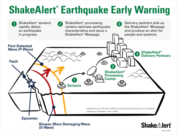
ShakeAlert 3 Basic Steps
ShakeAlert 3 Basic Steps: Sensor Networks to processing center to users.
ShakeAlert 3 Basic Steps: Sensor Networks to processing center to users.

U.S. River Conditions, Water Year 2021
This is an animation showing the changing conditions of USGS streamgages from October 1, 2020 to September 30, 2021. The river conditions shown range from the driest condition seen at a gage (red open circles) to the wettest (blue closed circles). A purple outer ring around a gage indicates it is flooding.
This is an animation showing the changing conditions of USGS streamgages from October 1, 2020 to September 30, 2021. The river conditions shown range from the driest condition seen at a gage (red open circles) to the wettest (blue closed circles). A purple outer ring around a gage indicates it is flooding.
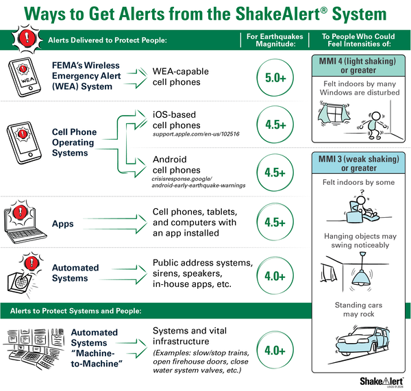
Alert Thresholds for ShakeAlert
Alert Delivery Thresholds used by ShakeAlert partners - The USGS issues ShakeAlert Messages but delivery of alerts will come by other public and private means (internet, radio, television, cellular), including Wireless Emergency Alerts (WEA) delivered by FEMA’s Integrated Public Alert and Warning System (IPAWS).
Alert Delivery Thresholds used by ShakeAlert partners - The USGS issues ShakeAlert Messages but delivery of alerts will come by other public and private means (internet, radio, television, cellular), including Wireless Emergency Alerts (WEA) delivered by FEMA’s Integrated Public Alert and Warning System (IPAWS).

Lava Flow Forecasting and Remote Sensing During 2018 Kīlauea Eruption
Lava Flow Forecasting and Remote Sensing During 2018 Kīlauea EruptionTalk by Hannah Dietterich–Alaska Volcano Observatory geologist. Talk originally presented at the American Geophysical Union Fall Meeting 2020.
Lava Flow Forecasting and Remote Sensing During 2018 Kīlauea Eruption
Lava Flow Forecasting and Remote Sensing During 2018 Kīlauea EruptionTalk by Hannah Dietterich–Alaska Volcano Observatory geologist. Talk originally presented at the American Geophysical Union Fall Meeting 2020.

USGS Studies Harmful Algal Blooms in New York
USGS scientists are studying water-quality conditions and harmful algal blooms—known as HABs—in Owasco, Seneca and Skaneateles lakes in New York. The USGS monitoring effort will provide a better understanding of HAB growth and severity and allow for near instantaneous detection of changing water-quality conditions that might be indicative of HAB development.
USGS scientists are studying water-quality conditions and harmful algal blooms—known as HABs—in Owasco, Seneca and Skaneateles lakes in New York. The USGS monitoring effort will provide a better understanding of HAB growth and severity and allow for near instantaneous detection of changing water-quality conditions that might be indicative of HAB development.
ShakeAlert Drop-Cover-Hold On Badge
ShakeAlert Drop-Cover-Hold On Badge
ShakeAlert Drop-Cover-Hold On Badge
Earthquake Early Warning - Overview
USGS is actively pursuing research in earthquake early warning.
Earthquake Early Warning – Fine-Tuning for Best Alerts
Release Date: OCTOBER 8, 2019 The goal of an earthquake early warning (EEW) system is to provide an alert to people and automatic systems after an earthquake begins but before the shaking reaches their location. As the USGS and its partners are developing an EEW system, called ShakeAlert®, for the West Coast, the benefits, costs, capabilities, and limitations are being investigated. Two recent...
The Nonindigenous Aquatic Species Alert Risk Mapper (ARM)
The Nonindigenous Aquatic Species (NAS) program has developed a new tool, the NAS Alert Risk Mapper (ARM), to characterize waterbodies in the conterminous U.S. and Hawaii at potential risk of invasion from a new nonindigenous species sighting.
ShakeAlert
The USGS ShakeAlert Earthquake Early Warning System uses earthquake science and technology to detect significant earthquakes quickly so that alerts can reach many people before shaking arrives. The seconds to tens of seconds of advance warning can allow people and systems to take actions to protect life and property from destructive shaking.
National Alert Risk Mapper for Nonindigenous Aquatic Species
The Nonindigenous Aquatic Species (NAS) Database and Alert System (https://nas.er.usgs.gov/default.aspx) provides a framework for the rapid dissemination of new invasions as they are incorporated into the NAS Database. The system notifies registered users of new sightings of >1,330 non-native aquatic species as part of national-scale early detection and rapid response systems (EDRR), and...

Volcano Notification Service (VNS)
The Volcano Notification Service (VNS) is a free service that sends you notification emails about volcanic activity happening at US monitored volcanoes.

Assessing Seasonal Wildfire Forecasting Methods in Alaska
In Alaska, increased wildfire activity has been linked to warming temperatures. Summers with extreme wildfire activity threaten life and property, clog the air with smoke, and challenge the state’s wildland firefighters. While the largest fires are often started by lightning and burn in remote areas, these fires require significant resources to fight when they threaten life and property.
Operational Earthquake Forecasting – Implementing a Real-Time System for California
It is well know that every earthquake can spawn others (e.g., as aftershocks), and that such triggered events can be large and damaging, as recently demonstrated by L’Aquila, Italy and Christchurch, New Zealand earthquakes. In spite of being an explicit USGS strategic-action priority (http://pubs.usgs.gov/of/2012/1088; page 32), the USGS currently lacks an automated system with which to...

ShakeAlert Infographic: Detect, Deliver, Protect
A ShakeAlert Message is an early warning from a network system that detects significant earthquakes quickly enough so that alerts can be delivered to people and automated systems potentially seconds before shaking arrives. ShakeAlert Messages are a product of the Advanced National Seismic System (ANSS). ShakeAlert can protect people and infrastructure by triggering automatic actions like slowing...
ShakeAlert Earthquake Early Warning
ShakeAlert Is Not Earthquake Prediction. Cartoon showing that the earthquake has already started when the ShakeAlert message is distributed.
ShakeAlert Is Not Earthquake Prediction. Cartoon showing that the earthquake has already started when the ShakeAlert message is distributed.
ShakeAlert 3 Basic Steps
ShakeAlert 3 Basic Steps: Sensor Networks to processing center to users.
ShakeAlert 3 Basic Steps: Sensor Networks to processing center to users.
U.S. River Conditions, Water Year 2021
This is an animation showing the changing conditions of USGS streamgages from October 1, 2020 to September 30, 2021. The river conditions shown range from the driest condition seen at a gage (red open circles) to the wettest (blue closed circles). A purple outer ring around a gage indicates it is flooding.
This is an animation showing the changing conditions of USGS streamgages from October 1, 2020 to September 30, 2021. The river conditions shown range from the driest condition seen at a gage (red open circles) to the wettest (blue closed circles). A purple outer ring around a gage indicates it is flooding.
Alert Thresholds for ShakeAlert
Alert Delivery Thresholds used by ShakeAlert partners - The USGS issues ShakeAlert Messages but delivery of alerts will come by other public and private means (internet, radio, television, cellular), including Wireless Emergency Alerts (WEA) delivered by FEMA’s Integrated Public Alert and Warning System (IPAWS).
Alert Delivery Thresholds used by ShakeAlert partners - The USGS issues ShakeAlert Messages but delivery of alerts will come by other public and private means (internet, radio, television, cellular), including Wireless Emergency Alerts (WEA) delivered by FEMA’s Integrated Public Alert and Warning System (IPAWS).
Lava Flow Forecasting and Remote Sensing During 2018 Kīlauea Eruption
Lava Flow Forecasting and Remote Sensing During 2018 Kīlauea EruptionTalk by Hannah Dietterich–Alaska Volcano Observatory geologist. Talk originally presented at the American Geophysical Union Fall Meeting 2020.
Lava Flow Forecasting and Remote Sensing During 2018 Kīlauea Eruption
Lava Flow Forecasting and Remote Sensing During 2018 Kīlauea EruptionTalk by Hannah Dietterich–Alaska Volcano Observatory geologist. Talk originally presented at the American Geophysical Union Fall Meeting 2020.
USGS Studies Harmful Algal Blooms in New York
USGS scientists are studying water-quality conditions and harmful algal blooms—known as HABs—in Owasco, Seneca and Skaneateles lakes in New York. The USGS monitoring effort will provide a better understanding of HAB growth and severity and allow for near instantaneous detection of changing water-quality conditions that might be indicative of HAB development.
USGS scientists are studying water-quality conditions and harmful algal blooms—known as HABs—in Owasco, Seneca and Skaneateles lakes in New York. The USGS monitoring effort will provide a better understanding of HAB growth and severity and allow for near instantaneous detection of changing water-quality conditions that might be indicative of HAB development.
ShakeAlert Drop-Cover-Hold On Badge
ShakeAlert Drop-Cover-Hold On Badge
ShakeAlert Drop-Cover-Hold On Badge

Why is it important to monitor volcanoes? Why is it important to monitor volcanoes?
There are 161 potentially active volcanoes in the United States. According to a 2018 USGS assessment, 57 volcanoes are a high threat or very high threat to public safety. Many of these volcanoes have erupted in the recent past and will erupt again in the foreseeable future. As populations increase, areas near volcanoes are being developed and aviation routes are increasing. As a result, more...

How can I obtain river forecasts (flood forecasts)? How can I obtain river forecasts (flood forecasts)?
River forecasts (flood forecasts) are made by the National Weather Service - National Water Prediction Service. The overall map on the website uses color designations to give a quick overview of current conditions. A legend and other information can be selected in the right column. From the main map, click on a station to bring up a box which includes a graph showing current information and a...

Why is elevation data so important to forecasting hurricane impact? Why is elevation data so important to forecasting hurricane impact?
The fundamental lesson of Hurricane Sandy in 2012 (and prior catastrophic storms and hurricanes) was that storm vulnerability is first and foremost a consequence of elevation. The height at which infrastructure, resources, and communities sit in relation to average tides and water levels, storm waves, surge, and flood waters determines their exposure to overwhelmingly powerful damaging forces...

What is the difference between earthquake early warning, earthquake forecasts, earthquake probabilities, and earthquake prediction? What is the difference between earthquake early warning, earthquake forecasts, earthquake probabilities, and earthquake prediction?
The USGS uses these four terms to refer to four different things. Early warning is a notification that is issued after an earthquake starts. Probabilities and forecasts are comparable to climate probabilities and weather forecasts, while predictions are more like statements of when, where, and how large, which is not yet possible for earthquakes. Here are more detailed descriptions of each...

Can the National Seismic Hazard Maps be used as an earthquake forecast tool for the near future? Can the National Seismic Hazard Maps be used as an earthquake forecast tool for the near future?
Not really. The USGS Seismic Hazard Maps website and the Unified Hazard Tool (for building custom maps) are designed to display the probability of different events that might occur in a several-year to several-decade period. The model bases all probability estimates on the average rate of earthquakes over long periods of time. As you shorten the time window, you should expect greater and greater...

How are floods predicted? How are floods predicted?
Flood predictions require several types of data: The amount of rainfall occurring on a real-time basis. The rate of change in river stage on a real-time basis, which can help indicate the severity and immediacy of the threat. Knowledge about the type of storm producing the moisture, such as duration, intensity and areal extent, which can be valuable for determining possible severity of the...
Can you predict earthquakes? Can you predict earthquakes?
No. Neither the USGS nor any other scientists have ever predicted a major earthquake. We do not know how, and we do not expect to know how any time in the foreseeable future. USGS scientists can only calculate the probability that a significant earthquake will occur ( shown on our hazard mapping) in a specific area within a certain number of years. An earthquake prediction must define 3 elements...

Can animals predict earthquakes? Can animals predict earthquakes?
The earliest reference we have to unusual animal behavior prior to a significant earthquake is from Greece in 373 BC. Rats, weasels, snakes, and centipedes reportedly left their homes and headed for safety several days before a destructive earthquake. Anecdotal evidence abounds of animals, fish, birds, reptiles, and insects exhibiting strange behavior anywhere from weeks to seconds before an...
How do I sign up for the ShakeAlert® Earthquake Early Warning System? How do I sign up for the ShakeAlert® Earthquake Early Warning System?
How do I sign up to receive ShakeAlert®-powered Alerts on my phone? Provider Type Apple Store Google Play Link States USGS/FEMA Wireless Emergency Alerts N/A FEMA | WEA CA/OR/WA MyShake TM Mobile App Y/Y MyShake CA/OR/WA Google Android Operating System N/A Google CA/OR/WA Alert San Diego with ShakeReadySD Mobile App Y/Y Alert San Diego CA The USGS issues ShakeAlert ® Messages but alert delivery...

Is there a way to get alerts about streamflow conditions? Is there a way to get alerts about streamflow conditions?
Yes! The U.S. Geological Survey WaterAlert service provides notifications to your email or phone for changes in water conditions based on thresholds you choose.

Can I get on a list to receive an email message when there is an earthquake? How do I sign up for earthquake notifications? Are there any Feeds I can subscribe to? Can I get on a list to receive an email message when there is an earthquake? How do I sign up for earthquake notifications? Are there any Feeds I can subscribe to?
Please go to the USGS Earthquake Notification Services (ENS) to sign up for free emails or text messages to your phone. Use the default settings or customize ENS to fit your needs. Also check out the many different Earthquake Feeds. ENS is NOT an earthquake early warning system. Messages issued by ENS will almost always arrive after you would feel any shaking. Learn more: How do I sign up for...

How quickly is earthquake information posted to the USGS website and sent out via the Earthquake Notification Service (ENS) and other feeds? How quickly is earthquake information posted to the USGS website and sent out via the Earthquake Notification Service (ENS) and other feeds?
USGS earthquake information mechanisms are all triggered by the same system, so they all receive the information at the same time. The time it takes for the system to receive the information primarily depends on the size and location of the earthquake: An earthquake in California is processed and posted to the system in 2.5 minutes (on average). This is because our seismic network is very...
Time is critical in a disaster. Every second matters. Knowing where hazards are and being able to alert people before they occur can save lives. The USGS has numerous systems in place to notify people of risk or impending dangerous conditions associated with natural hazards.
Living in Harm's Way
Theoretically, disasters could be avoided if people didn’t live in hazardous areas. However, realistically, that is impossible. Because no matter where people live, some form of natural hazard will likely threaten them at some point. Whether it is an earthquake, wildfire, flood, hurricane, eruption, or something else, Earth tends to throw people into harm’s way regardless of what we do. So, the best we can do is be prepared, and with the help of some innovative technologies, possibly get alerted of an impending threat.
Learn how USGS works with partners, emergency planners, and managers to provide hazard data alerts, forecasts, and monitoring and notification systems. From earthquakes to harmful algal blooms, USGS scientists are on the cutting edge in understanding when, where, and what we need to do to avoid loss.
Alerts
From wildfires to flooding to earthquake early warnings, USGS helps provide warnings in time to get ready and get out of harm’s way. You and your family can subscribe to many of them.
WaterAlert
WaterAlert
ShakeAlert® Earthquake Early Warning
ShakeAlert® Earthquake Early Warning
Alaska Harmful Algal Bloom Network
Alaska Harmful Algal Bloom Network
Volcano Updates
Volcano Updates
Notifications
In addition to monitoring, USGS actively works to notify people about possible threats. By raising awareness people can plan, act, and avoid threats from natural hazards. A few extra seconds can afford people time to act, whether this is evacuating or dropping, covering, and holding on.
Earthquakes Notification Service
Earthquakes Notification Service
Volcano Notification Service
Volcano Notification Service
WaterNow
WaterNow
Forecasting
In other cases, community alerts, forecasting, and drills give people critical time to prepare or avoid the disaster.
Postfire Debris Flows
Postfire Debris Flows
Aftershock Forecast
Aftershock Forecast
Fire Danger Forecast
Fire Danger Forecast
Forecasting Coastal Change
Forecasting Coastal Change
Informational Services
The USGS brings a range of expertise to observing potential threats in our Nation’s land, air, and water. Here are a few examples of real-time data we distribute free of charge.
Latest Earthquakes
Latest Earthquakes
Wildfire Conditions
Wildfire Conditions
National Water Dashboard
National Water Dashboard
Current Volcano Activity
Current Volcano Activity
Citizen Science Observations
Citizen science allows you to contribute to science no matter where you are. Whether by asking questions, reporting observations, or collecting data, you and other members of the public can use your talents to help advance scientific knowledge.
Did You Feel It?
Did You Feel It?
Report Volcanic Ash - Alaska
Report Volcanic Ash - Alaska
Report Nonindigenous Aquatic Species
Report Nonindigenous Aquatic Species
WHISPers Wildlife Disease Reporting
WHISPers Wildlife Disease Reporting
Science
Earthquake Early Warning - Overview
USGS is actively pursuing research in earthquake early warning.
Earthquake Early Warning – Fine-Tuning for Best Alerts
Release Date: OCTOBER 8, 2019 The goal of an earthquake early warning (EEW) system is to provide an alert to people and automatic systems after an earthquake begins but before the shaking reaches their location. As the USGS and its partners are developing an EEW system, called ShakeAlert®, for the West Coast, the benefits, costs, capabilities, and limitations are being investigated. Two recent...
The Nonindigenous Aquatic Species Alert Risk Mapper (ARM)
The Nonindigenous Aquatic Species (NAS) program has developed a new tool, the NAS Alert Risk Mapper (ARM), to characterize waterbodies in the conterminous U.S. and Hawaii at potential risk of invasion from a new nonindigenous species sighting.
ShakeAlert
The USGS ShakeAlert Earthquake Early Warning System uses earthquake science and technology to detect significant earthquakes quickly so that alerts can reach many people before shaking arrives. The seconds to tens of seconds of advance warning can allow people and systems to take actions to protect life and property from destructive shaking.
National Alert Risk Mapper for Nonindigenous Aquatic Species
The Nonindigenous Aquatic Species (NAS) Database and Alert System (https://nas.er.usgs.gov/default.aspx) provides a framework for the rapid dissemination of new invasions as they are incorporated into the NAS Database. The system notifies registered users of new sightings of >1,330 non-native aquatic species as part of national-scale early detection and rapid response systems (EDRR), and...
Multimedia
ShakeAlert Earthquake Early Warning
ShakeAlert Is Not Earthquake Prediction. Cartoon showing that the earthquake has already started when the ShakeAlert message is distributed.
ShakeAlert Is Not Earthquake Prediction. Cartoon showing that the earthquake has already started when the ShakeAlert message is distributed.
ShakeAlert 3 Basic Steps
ShakeAlert 3 Basic Steps: Sensor Networks to processing center to users.
ShakeAlert 3 Basic Steps: Sensor Networks to processing center to users.
U.S. River Conditions, Water Year 2021
This is an animation showing the changing conditions of USGS streamgages from October 1, 2020 to September 30, 2021. The river conditions shown range from the driest condition seen at a gage (red open circles) to the wettest (blue closed circles). A purple outer ring around a gage indicates it is flooding.
This is an animation showing the changing conditions of USGS streamgages from October 1, 2020 to September 30, 2021. The river conditions shown range from the driest condition seen at a gage (red open circles) to the wettest (blue closed circles). A purple outer ring around a gage indicates it is flooding.
Alert Thresholds for ShakeAlert
Alert Delivery Thresholds used by ShakeAlert partners - The USGS issues ShakeAlert Messages but delivery of alerts will come by other public and private means (internet, radio, television, cellular), including Wireless Emergency Alerts (WEA) delivered by FEMA’s Integrated Public Alert and Warning System (IPAWS).
Alert Delivery Thresholds used by ShakeAlert partners - The USGS issues ShakeAlert Messages but delivery of alerts will come by other public and private means (internet, radio, television, cellular), including Wireless Emergency Alerts (WEA) delivered by FEMA’s Integrated Public Alert and Warning System (IPAWS).
Lava Flow Forecasting and Remote Sensing During 2018 Kīlauea Eruption
Lava Flow Forecasting and Remote Sensing During 2018 Kīlauea EruptionTalk by Hannah Dietterich–Alaska Volcano Observatory geologist. Talk originally presented at the American Geophysical Union Fall Meeting 2020.
Lava Flow Forecasting and Remote Sensing During 2018 Kīlauea Eruption
Lava Flow Forecasting and Remote Sensing During 2018 Kīlauea EruptionTalk by Hannah Dietterich–Alaska Volcano Observatory geologist. Talk originally presented at the American Geophysical Union Fall Meeting 2020.
USGS Studies Harmful Algal Blooms in New York
USGS scientists are studying water-quality conditions and harmful algal blooms—known as HABs—in Owasco, Seneca and Skaneateles lakes in New York. The USGS monitoring effort will provide a better understanding of HAB growth and severity and allow for near instantaneous detection of changing water-quality conditions that might be indicative of HAB development.
USGS scientists are studying water-quality conditions and harmful algal blooms—known as HABs—in Owasco, Seneca and Skaneateles lakes in New York. The USGS monitoring effort will provide a better understanding of HAB growth and severity and allow for near instantaneous detection of changing water-quality conditions that might be indicative of HAB development.
ShakeAlert Drop-Cover-Hold On Badge
ShakeAlert Drop-Cover-Hold On Badge
ShakeAlert Drop-Cover-Hold On Badge
Earthquake Early Warning - Overview
USGS is actively pursuing research in earthquake early warning.
Earthquake Early Warning – Fine-Tuning for Best Alerts
Release Date: OCTOBER 8, 2019 The goal of an earthquake early warning (EEW) system is to provide an alert to people and automatic systems after an earthquake begins but before the shaking reaches their location. As the USGS and its partners are developing an EEW system, called ShakeAlert®, for the West Coast, the benefits, costs, capabilities, and limitations are being investigated. Two recent...
The Nonindigenous Aquatic Species Alert Risk Mapper (ARM)
The Nonindigenous Aquatic Species (NAS) program has developed a new tool, the NAS Alert Risk Mapper (ARM), to characterize waterbodies in the conterminous U.S. and Hawaii at potential risk of invasion from a new nonindigenous species sighting.
ShakeAlert
The USGS ShakeAlert Earthquake Early Warning System uses earthquake science and technology to detect significant earthquakes quickly so that alerts can reach many people before shaking arrives. The seconds to tens of seconds of advance warning can allow people and systems to take actions to protect life and property from destructive shaking.
National Alert Risk Mapper for Nonindigenous Aquatic Species
The Nonindigenous Aquatic Species (NAS) Database and Alert System (https://nas.er.usgs.gov/default.aspx) provides a framework for the rapid dissemination of new invasions as they are incorporated into the NAS Database. The system notifies registered users of new sightings of >1,330 non-native aquatic species as part of national-scale early detection and rapid response systems (EDRR), and...
Volcano Notification Service (VNS)
The Volcano Notification Service (VNS) is a free service that sends you notification emails about volcanic activity happening at US monitored volcanoes.
Assessing Seasonal Wildfire Forecasting Methods in Alaska
In Alaska, increased wildfire activity has been linked to warming temperatures. Summers with extreme wildfire activity threaten life and property, clog the air with smoke, and challenge the state’s wildland firefighters. While the largest fires are often started by lightning and burn in remote areas, these fires require significant resources to fight when they threaten life and property.
Operational Earthquake Forecasting – Implementing a Real-Time System for California
It is well know that every earthquake can spawn others (e.g., as aftershocks), and that such triggered events can be large and damaging, as recently demonstrated by L’Aquila, Italy and Christchurch, New Zealand earthquakes. In spite of being an explicit USGS strategic-action priority (http://pubs.usgs.gov/of/2012/1088; page 32), the USGS currently lacks an automated system with which to...
ShakeAlert Infographic: Detect, Deliver, Protect
A ShakeAlert Message is an early warning from a network system that detects significant earthquakes quickly enough so that alerts can be delivered to people and automated systems potentially seconds before shaking arrives. ShakeAlert Messages are a product of the Advanced National Seismic System (ANSS). ShakeAlert can protect people and infrastructure by triggering automatic actions like slowing...
ShakeAlert Earthquake Early Warning
ShakeAlert Is Not Earthquake Prediction. Cartoon showing that the earthquake has already started when the ShakeAlert message is distributed.
ShakeAlert Is Not Earthquake Prediction. Cartoon showing that the earthquake has already started when the ShakeAlert message is distributed.
ShakeAlert 3 Basic Steps
ShakeAlert 3 Basic Steps: Sensor Networks to processing center to users.
ShakeAlert 3 Basic Steps: Sensor Networks to processing center to users.
U.S. River Conditions, Water Year 2021
This is an animation showing the changing conditions of USGS streamgages from October 1, 2020 to September 30, 2021. The river conditions shown range from the driest condition seen at a gage (red open circles) to the wettest (blue closed circles). A purple outer ring around a gage indicates it is flooding.
This is an animation showing the changing conditions of USGS streamgages from October 1, 2020 to September 30, 2021. The river conditions shown range from the driest condition seen at a gage (red open circles) to the wettest (blue closed circles). A purple outer ring around a gage indicates it is flooding.
Alert Thresholds for ShakeAlert
Alert Delivery Thresholds used by ShakeAlert partners - The USGS issues ShakeAlert Messages but delivery of alerts will come by other public and private means (internet, radio, television, cellular), including Wireless Emergency Alerts (WEA) delivered by FEMA’s Integrated Public Alert and Warning System (IPAWS).
Alert Delivery Thresholds used by ShakeAlert partners - The USGS issues ShakeAlert Messages but delivery of alerts will come by other public and private means (internet, radio, television, cellular), including Wireless Emergency Alerts (WEA) delivered by FEMA’s Integrated Public Alert and Warning System (IPAWS).
Lava Flow Forecasting and Remote Sensing During 2018 Kīlauea Eruption
Lava Flow Forecasting and Remote Sensing During 2018 Kīlauea EruptionTalk by Hannah Dietterich–Alaska Volcano Observatory geologist. Talk originally presented at the American Geophysical Union Fall Meeting 2020.
Lava Flow Forecasting and Remote Sensing During 2018 Kīlauea Eruption
Lava Flow Forecasting and Remote Sensing During 2018 Kīlauea EruptionTalk by Hannah Dietterich–Alaska Volcano Observatory geologist. Talk originally presented at the American Geophysical Union Fall Meeting 2020.
USGS Studies Harmful Algal Blooms in New York
USGS scientists are studying water-quality conditions and harmful algal blooms—known as HABs—in Owasco, Seneca and Skaneateles lakes in New York. The USGS monitoring effort will provide a better understanding of HAB growth and severity and allow for near instantaneous detection of changing water-quality conditions that might be indicative of HAB development.
USGS scientists are studying water-quality conditions and harmful algal blooms—known as HABs—in Owasco, Seneca and Skaneateles lakes in New York. The USGS monitoring effort will provide a better understanding of HAB growth and severity and allow for near instantaneous detection of changing water-quality conditions that might be indicative of HAB development.
ShakeAlert Drop-Cover-Hold On Badge
ShakeAlert Drop-Cover-Hold On Badge
ShakeAlert Drop-Cover-Hold On Badge
Why is it important to monitor volcanoes? Why is it important to monitor volcanoes?
There are 161 potentially active volcanoes in the United States. According to a 2018 USGS assessment, 57 volcanoes are a high threat or very high threat to public safety. Many of these volcanoes have erupted in the recent past and will erupt again in the foreseeable future. As populations increase, areas near volcanoes are being developed and aviation routes are increasing. As a result, more...
How can I obtain river forecasts (flood forecasts)? How can I obtain river forecasts (flood forecasts)?
River forecasts (flood forecasts) are made by the National Weather Service - National Water Prediction Service. The overall map on the website uses color designations to give a quick overview of current conditions. A legend and other information can be selected in the right column. From the main map, click on a station to bring up a box which includes a graph showing current information and a...
Why is elevation data so important to forecasting hurricane impact? Why is elevation data so important to forecasting hurricane impact?
The fundamental lesson of Hurricane Sandy in 2012 (and prior catastrophic storms and hurricanes) was that storm vulnerability is first and foremost a consequence of elevation. The height at which infrastructure, resources, and communities sit in relation to average tides and water levels, storm waves, surge, and flood waters determines their exposure to overwhelmingly powerful damaging forces...
What is the difference between earthquake early warning, earthquake forecasts, earthquake probabilities, and earthquake prediction? What is the difference between earthquake early warning, earthquake forecasts, earthquake probabilities, and earthquake prediction?
The USGS uses these four terms to refer to four different things. Early warning is a notification that is issued after an earthquake starts. Probabilities and forecasts are comparable to climate probabilities and weather forecasts, while predictions are more like statements of when, where, and how large, which is not yet possible for earthquakes. Here are more detailed descriptions of each...
Can the National Seismic Hazard Maps be used as an earthquake forecast tool for the near future? Can the National Seismic Hazard Maps be used as an earthquake forecast tool for the near future?
Not really. The USGS Seismic Hazard Maps website and the Unified Hazard Tool (for building custom maps) are designed to display the probability of different events that might occur in a several-year to several-decade period. The model bases all probability estimates on the average rate of earthquakes over long periods of time. As you shorten the time window, you should expect greater and greater...
How are floods predicted? How are floods predicted?
Flood predictions require several types of data: The amount of rainfall occurring on a real-time basis. The rate of change in river stage on a real-time basis, which can help indicate the severity and immediacy of the threat. Knowledge about the type of storm producing the moisture, such as duration, intensity and areal extent, which can be valuable for determining possible severity of the...
Can you predict earthquakes? Can you predict earthquakes?
No. Neither the USGS nor any other scientists have ever predicted a major earthquake. We do not know how, and we do not expect to know how any time in the foreseeable future. USGS scientists can only calculate the probability that a significant earthquake will occur ( shown on our hazard mapping) in a specific area within a certain number of years. An earthquake prediction must define 3 elements...
Can animals predict earthquakes? Can animals predict earthquakes?
The earliest reference we have to unusual animal behavior prior to a significant earthquake is from Greece in 373 BC. Rats, weasels, snakes, and centipedes reportedly left their homes and headed for safety several days before a destructive earthquake. Anecdotal evidence abounds of animals, fish, birds, reptiles, and insects exhibiting strange behavior anywhere from weeks to seconds before an...
How do I sign up for the ShakeAlert® Earthquake Early Warning System? How do I sign up for the ShakeAlert® Earthquake Early Warning System?
How do I sign up to receive ShakeAlert®-powered Alerts on my phone? Provider Type Apple Store Google Play Link States USGS/FEMA Wireless Emergency Alerts N/A FEMA | WEA CA/OR/WA MyShake TM Mobile App Y/Y MyShake CA/OR/WA Google Android Operating System N/A Google CA/OR/WA Alert San Diego with ShakeReadySD Mobile App Y/Y Alert San Diego CA The USGS issues ShakeAlert ® Messages but alert delivery...
Is there a way to get alerts about streamflow conditions? Is there a way to get alerts about streamflow conditions?
Yes! The U.S. Geological Survey WaterAlert service provides notifications to your email or phone for changes in water conditions based on thresholds you choose.
Can I get on a list to receive an email message when there is an earthquake? How do I sign up for earthquake notifications? Are there any Feeds I can subscribe to? Can I get on a list to receive an email message when there is an earthquake? How do I sign up for earthquake notifications? Are there any Feeds I can subscribe to?
Please go to the USGS Earthquake Notification Services (ENS) to sign up for free emails or text messages to your phone. Use the default settings or customize ENS to fit your needs. Also check out the many different Earthquake Feeds. ENS is NOT an earthquake early warning system. Messages issued by ENS will almost always arrive after you would feel any shaking. Learn more: How do I sign up for...
How quickly is earthquake information posted to the USGS website and sent out via the Earthquake Notification Service (ENS) and other feeds? How quickly is earthquake information posted to the USGS website and sent out via the Earthquake Notification Service (ENS) and other feeds?
USGS earthquake information mechanisms are all triggered by the same system, so they all receive the information at the same time. The time it takes for the system to receive the information primarily depends on the size and location of the earthquake: An earthquake in California is processed and posted to the system in 2.5 minutes (on average). This is because our seismic network is very...